CFHC Talkback For News Story #108:
Newest Talkback: 10:43 PM 09-21 EDT

Tropical Storm Watches... TD#13 Forms in East Atlantic
10:54 AM EDT - 21 September 2000

5PM Update:
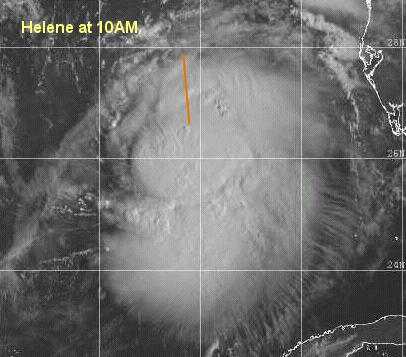
Hurricane Watches are up from Florida/Alabama Border to the mouth of the Alucilla River to the east. Helene has a chance of becoming a minimal hurricane before landfall. Right now the center is nearly exposed, so it's holding on. However, I still think it may strengthen. In any case, this is another big rain bringer. TD#13 hasn't strengthened any yet.

Busy again. Tropical Depression #13 forms in the east Atlantic.

It should track generally westward for the moment and eventually turn north. If in two days or so it doesn't turn north then a more westward track is possible.

Tropical Storm Helene has prompted Tropical Storm Warnings from the mouth of the Pearl River to the mouth of the Aucilla river. It could become a strong Tropical Storm before landfall, and a minimal hurricane is not out of the question either.

More to come later...

Helene

Comments or Questions? Everyone is invited to use it. Use the comment button by the story Headline.

Joseph Johnston's Mobile Alabama Webcam (Hosted on CFHC)

NRL Monterey Marine Meteorology Division Forecast Track of Active Systems (Good Forecast Track Graphic and Satellite Photos)
Map with nearly all model projected tracks plotted for Helene. And TD#13 From Michael Bryson.
Crown Weather Services Tropical Update (Includes Map with multiple forecast model tracks)
Snonut's Hurricane Reports
Satellite images at: [Visible] (visible -- Daytime Only) [Infrared] (infrared), and [Water Vapor] (water vapor)
Loops: Visible Loop - Infrared Loop - Water Vapor Loop
NASA GHCC Interactive Satellite images at:
[NAtl visible] (visible -- Daytime Only) [NAtl infrared] (infrared), and [NAtl water vapor] (water vapor)--Nasa source.
Ocean Surface Winds Derived from the SeaWinds Scatterometer (Experimental)
Tormenta.net Español -- Gran información sobre huracanes aquí.

Some Forecast models: (NGM, AVN, MRF, ECMWF, ETA)
DoD weather models (NOGAPS, AVN, MRF)
AVN, ECMWF, GFDL, NOGAPS, UKMET

- [mac]


Show All Comments | Show Next 18 Comments

Displaying Talkbacks #1 - #18 (of 39 total)

helene-future track (#1)
Posted by:
Doug Spangler Location: sarasota
Posted On 12:37PM 21-Sep-2000 with id (RPTNQTTNQNTQ*)


Once again, if we follow the theorey that these systems seem to follow the moisture flow, an approach that held up fairly well last weekend, then everybody in the bigbend fo Florida should pay attention..the WV loop is showing a definite eastward push...the moisture that was pushing n into Texas is now moving east..between it and Helene is some slightly drier air also moving east, no appreciable moisture is moving n into Apalachee bay-west area...my guess is more eastward on future track from here on out. This is a situation where the upper level flow is definite w-e while the low level steerin currents are still s-n. Doesn't make for favorable conditions for further strengthening. EDS.

helene-future track (#2)
Posted by:
Doug Spangler Location: sarasota
Posted On 12:38PM 21-Sep-2000 with id (RPTNQTTNQNTQ*)


Once again, if we follow the theorey that these systems seem to follow the moisture flow, an approach that held up fairly well last weekend, then everybody in the bigbend fo Florida should pay attention..the WV loop is showing a definite eastward push...the moisture that was pushing n into Texas is now moving east..between it and Helene is some slightly drier air also moving east, no appreciable moisture is moving n into Apalachee bay-west area...my guess is more eastward on future track from here on out. This is a situation where the upper level flow is definite w-e while the low level steerin currents are still s-n. Doesn't make for favorable conditions for further strengthening. EDS.

That is Exactly What I said Earlier This Morning! (#3)
Posted by:
Colleen Location: Lakeland, Florida
Posted On 12:56PM 21-Sep-2000 with id (RPUNQXXNQYYNTX*)


Glad someone else noticed that also!

A house divided (#4)
Posted by: Steve H
Posted On 01:03PM 21-Sep-2000 with id (QSRNRRXNWPNQX*)


Appears that the circulation and the convection are parting company. Circulation heading NNW/Convection heading NE. We'll see if they get back together, but it looks like this storm could weaken. cheers!

Good Observations Steve (#5)
Posted by:
Frank Location: Biloxi MS
Posted On 01:28PM 21-Sep-2000 with id (QRNQSNRTXNT*)


Latest vis sat pix indicates LLC still heading nnw while convections is getting sheared to ne... IMO system is struggling and until it starts building some convection on the west side, which probably won't happen, this thing is going to remain weak..

Doubt it (#6)
Posted by: L.T. (
http://www.ssd.noaa.gov/SAB/TROP/DATA/img/GMEXIR4.html) Location: Pensacola, FL
Posted On 01:30PM 21-Sep-2000 with id (RPUNQXXNRPPNRY*)


Looks well rounded and organzied to me, I don't see AT ALL what you all are talking about, its moving clearly NNW.

LT... (#7)
Posted by:
Frank Location: Biloxi MS
Posted On 01:41PM 21-Sep-2000 with id (QRNQSNRTXNQR*)


LT, The sat pix you reference doesn't give a very good picture of the LLC... which must be stacked with the MCL for strengthing, and also needs high pressure aloft for this thing to vent.. I agree with you that the system is moving nnw but its obvious the MLC is getting sheared and its not stacking well at all ...try this loop

http://kauai.nrlmry.navy.mil/sat-bin/tc_home

L.T. (#8)
Posted by:
Colleen Location: Lakeland, Florida
Posted On 01:42PM 21-Sep-2000 with id (RPUNQXXNQYYNSV*)


Next time TWC is on, take a good look at the water vapor imagery. It's very obvious that the winds are pushing against the LLCC, which is why there is no heavy banding on the western side of the system. If you are looking at it and trying to see the llcc in the middle, you are looking in the wrong place. There is a lot of dry air to the west of this system, which is why the above posts are saying what they are saying.

Relocated Coordinates (#9)
Posted by:
Colleen Location: Lakeland, Florida
Posted On 01:44PM 21-Sep-2000 with id (RPUNQXXNQYYNSV*)


Found the following info:

TPNT KGWC 211625

A. TROPICAL STORM HELENE

B. 21/1437Z (115)

C. 26.3N/1

D. 87.0W/5

E. THREE/DMSP

F. T2.5/2.5/D1.0 18HRS -21/1115Z-

G. WX5548/17881/DLS-TS-EIR-MI/D


20/ PBO XPSD LLCC ON 85H DATA. LLCC IS CLEARLY INDICATED BY WHITE

BANDS ON SSMI IMAGERY.


Well (#10)
Posted by: L.T. (
http://www.ssd.noaa.gov/SAB/TROP/DATA/img/GMEXIR4.html) Location: Pensacola, FL
Posted On 01:50PM 21-Sep-2000 with id (QURNQVSNRPQNQXY*)


Looks better than it EVER has.

Florida Bound (#11)
Posted by: Tom
Posted On 01:53PM 21-Sep-2000 with id (QSRNRRXNWPNQX*)


With those coordinates (26.3/87.0)its further south and east then @ 11:00, whats going on.

MLCC Moving East? (#12)
Posted by: StormHound (
http://www.stormhound.homestead.com) Location: O-Town
Posted On 01:55PM 21-Sep-2000 with id (QRNSUNQWNR*)


I agree with Colleen and Steve H. If you look at the I/R images, which generally show mid-level action, the system is clearly squashed on the West side. This would indicate the mid-level is being pushed west, while the low-level still seems to be generally moving north.

T#'s (#13)
Posted by:
Colleen Location: Lakeland, Florida
Posted On 02:00PM 21-Sep-2000 with id (RPUNQXXNQYYNSV*)


I think what those T #'s mean is exactly what said: the westerly shear is pushing it more to the south and east, while the llcc move more to the north.

As far as the track and intensity go, I have about as much faith in them as I do in letting my cat drive my car on I-75.


Stormhound (#14)
Posted by:
Colleen Location: Lakeland, Florida
Posted On 02:03PM 21-Sep-2000 with id (RPUNQXXNQYYNSV*)


Did you mean it is being pushed east? You said west...

LT...yes, the system does look organized, but on the EASTERN side, not the WESTERN side. I am not trying to be argumentative, but I don't think you are looking in the right place for the llcc.

Even on the latest Visible pictures you can see the MLC being pushed east. Sorry to disagree with you on this one, but I have to.

Colleen

Well (#15)
Posted by: L.T. (
http://www.ssd.noaa.gov/SAB/TROP/DATA/img/GMEXIR4.html) Location: Pensacola, FL
Posted On 02:13PM 21-Sep-2000 with id (QURNQVSNQYWNRPY*)


I Agree but the thing is down to 999mb, its pressure is dropping and its still gaining, I'm worried, the track is right over my area, sorry if I'm upbeat but that happens when I'm threatened!!

L.T. (#16)
Posted by:
Colleen Location: Lakeland, Florida
Posted On 02:21PM 21-Sep-2000 with id (RPUNQXXNQYYNUQ*)


I understand, just went through it last week, so you don't have to apologize. Of course you would be worried, we all should be. Now they are saying it should level off, so hopefully, it won't get any stronger; although, I have to tell you, my confidence is lower than ever this year with guidance on these stupid storms. Wish it would just snow a lot!!! Colleen

Recon Report (#17)
Posted by:
Colleen Location: Lakeland, Florida
Posted On 02:42PM 21-Sep-2000 with id (RPUNQXXNQYYNUQ*)


Please tell me if these numbers do not match the T#'s I posted above:

000
URNT12 KNHC 211708
VORTEX DATA MESSAGE
A. 21/1708Z
B. 26 DEG 53 MIN N
87 DEG 03 MIN W
C. NA
D. 35 KT
E. 213 DEG 16 NM
F. 285 DEG 41 KT
G. 216 DEG 13 NM
H. EXTRAP 999 MB
I. 24 C/ 304 M
J. 27 C/ 305 M
K. 24 C/ NA
L. NA
M. NA
N. 1345 /01
O. 0.6/2 NM
P. AF967 0612A INVEST OB 16
MAX FL WIND 58 KT N QUAD 1329Z. SLP EXTRAP FROM 1500FT.

I am sure I have this mixed up again. Thanksfor your help.

Yes Colleen (#18)
Posted by: StormHound (
http://www.stormhound.homestead.com) Location: O-Town
Posted On 02:44PM 21-Sep-2000 with id (QRNSUNQWNR*)


Yes, sorry, I meant to say East. What I meant was that the West side is pushed in, meaning its being pushed to the East.

Which means (#19)
Posted by: L.T. (
http://www.ssd.noaa.gov/SAB/TROP/DATA/img/GMEXIR4.html) Location: Pensacola, FL
Posted On 02:46PM 21-Sep-2000 with id (QURNQVSNQYWNRPV*)


The East side of the storm is strongest, its going in around Ft. Walton, FL. All the Models have it going in around there.


Show All Comments | Show Next 18 Comments


Return to Central Florida Hurricane Center Main Page