CFHC Talkback For News Story #39:
Newest Talkback: 09:24 PM 06-05 EDT

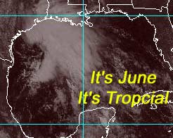
Tropical Depression Forming in Gulf of Mexico
11:46 AM EDT - 05 June 2001

I may be wrong about the first named system timeframe. We'll most likely have one in June... and early at that... like today. It's possible we have a tropical storm or depression in the Northwest Gulf of Mexico. It's moving slowly toward the Texas and Louisiana coastlines.

This morning some organization has occurred, and we may have our first tropical depression of the season this afternoon. It may even be a storm. Any comments on this early action?

June???


Joe Bastardi's season predictions should be up today.

The Weather Channel's Storm week focuses on Hurricanes tonight at 9PM EDT.

Satellite images at: [Visible] (visible -- Daytime Only) [Infrared] (infrared), and [Water Vapor] (water vapor)
Loops: Visible Loop - Infrared Loop - Water Vapor Loop
NASA GHCC Interactive Satellite images at:
[NAtl visible] (visible -- Daytime Only) [NAtl infrared] (infrared), and [NAtl water vapor] (water vapor)--Nasa source.
Defiant Visible Infrared More...
Some Forecast models: (NGM, AVN, MRF, ECMWF, ETA)
DoD weather models (NOGAPS, AVN, MRF)
AVN, ECMWF, GFDL, NOGAPS, UKMET

- [mac]


Show All Comments

Displaying Talkbacks #1 - #18 (of 18 total)

Soon to be TD 1 (#1)
Posted by: Alex K
Posted On 12:38PM 05-Jun-2001 with id (VSNTRNQTTNXU*)


I believe that the most probable prediction is that it will become a depression early this afternoon. However, unless it stalls, I think it is a bit unlikely that it will become a TS. That is, unless it is already one because of higher than expected winds. Like I said before, I believe this is unprobable.

Possible TS (#2)
Posted by:
Richard Byett (http://www.stormwarn2000.com) Location: Gloucester, England
Posted On 01:12PM 05-Jun-2001 with id (RQSNQRRNQPWNQUW*)


As i have previously said, i beleive we would have an early season storm, and it looks like i may be correct. Recent obbs indicated from an oil rig, sustained winds as high as 50 mph, and gusts to 60. Granted these reading were taken at several hundred feet, but with a little more organisation this system will probably become a TS, if it is not already. I would not be surprised to see TS watches, even TS WARNINGS up for parts f the Texas, Louisianna coast within the next few hours, especially if the recon flight indicates further strengthening.

Any way, i will be posting back shortly :)


nothing really..... (#3)
Posted by:
gary Location: jacksonville
Posted On 01:30PM 05-Jun-2001 with id (RPUNQURNVUNR*)


It doesn't really matter if its a tropical storm or just a depression. I am just happy to see something worthwhile to talk about on the screen.
I really hope that the system comes to Florida and just pours on us, maybe that will help us get rid of this drought. Any thoughts on this turning towards Florida?

T1.5 (#4)
Posted by: Gary (
http://†) Location: Hernando Beach fl.
Posted On 01:31PM 05-Jun-2001 with id (RPYNTNTQNRRT*)


TPNT KGWC 051709

A. DISTURBANCE IN THE GULF OF MEXICO

B. 05/1513Z (39)

C. 27.4N/3

D. 94.8W/1

E. FIVE/DMSP

F. T1.5/1.5/INIT OBS -05/1315Z-

G. WX5548/21512/DLS-TS-EIR-MI/D


49S/ PBO PRTLY XPSD LLCC ON 85H DATA AND OLS IMAGERY. WESTERN

HALF OF LLCC APPEARS WEAK ON 85H DATA.


H. CENTER WAS 0.5 DEGREES WEST OF NADIR.


I take it that was the Recon info? n/m (#5)
Posted by:
Colleen Location: Lakeland
Posted On 02:14PM 05-Jun-2001 with id (VTNQRNQPRNSW*)


Thanks for the update....

Reforming (#6)
Posted by: cajun
Posted On 02:26PM 05-Jun-2001 with id (QRNTPNRWNRRT*)


Is it just me or is this thing reforming further south

recon info (#7)
Posted by: Alex K
Posted On 02:34PM 05-Jun-2001 with id (VSNTRNQTSNRTW*)


Does anyone know if the hurricane hunters found a closed circulation? Thanks

To Colleen (#8)
Posted by: Gary (
http://†) Location: Hernando Beach fl.
Posted On 02:35PM 05-Jun-2001 with id (RPYNTNQWNRSY*)


My post was not recon. It was Dvorak satellite estimate of tropical storm intensity. A 1.5 is 25knots and not a storm yet but close.

Thanks, Gary! and to Alex (#9)
Posted by:
Colleen Location: Lakeland
Posted On 02:40PM 05-Jun-2001 with id (VTNQRNQPRNSW*)


Thank you, Gary....wouldn't 25 knts just be 2mph short of a TS? A weak one, albeit....but one anyway..

Alex...I do not believe they found a closed circulation center..I would think we'll know by 4 or 5pm...or earlier what they are going to classify this as...my bet is TS Allison, but then again...I'm not a gambling person!!! Colleen


thank you (#10)
Posted by: Alex K
Posted On 02:43PM 05-Jun-2001 with id (VSNTRNQTSNRTW*)


Thank you Coleen for informing me. I bet it will be upgraded at 4 pm central time, also.

Tropical Storm Allison Forms (#11)
Posted by:
Mark Location: Ft Myers Fla
Posted On 02:59PM 05-Jun-2001 with id (QRNWWNQWWNUQ*)


At 2pm the NHC has upgraded the gulf system to a tropical storm Allison with winds of 60 mph. Tropical storm warnings have been posted along the Texas Louisana coast for winds and rains to move in over the next 12 hours. Here we go folks!!

Tropical Storm Allison Forms (#12)
Posted by:
Mark Location: Ft Myers Fla
Posted On 03:00PM 05-Jun-2001 with id (QRNWWNQWWNUQ*)


At 2pm the NHC has upgraded the gulf system to a tropical storm Allison with winds of 60 mph. Tropical storm warnings have been posted along the Texas Louisana coast for winds and rains to move in over the next 12 hours. Here we go folks!!

Boy....Only 5 Days into the Season! (#13)
Posted by:
Colleen Location: Lakeland
Posted On 03:11PM 05-Jun-2001 with id (VTNQRNQPRNUQ*)


I should have made a bet...darn....I'll be interested to see the track after landfall....

ALLISON (#14)
Posted by: scottsvb (
http://communities.msn.com/HURRICANEUPDATECENTER) Location: tampa
Posted On 03:26PM 05-Jun-2001 with id (QRNWWNQTSNQWY*)


T.S ALLISON HAS FORMED THIS AFTERNOON.
As I predicted on a earlier topic I saw
1 TD or TS this month and a few smaller
swirls that wont be classified.
Allison actually orginated in the eastern
pacific just south of Mexico. The mid level
winds carried her into the Bay of Campeache
and the western gulf as a mid level low and
a tropical pacific surge of moisture.
Allison is very close to land and should come
onshore near the TX,LA coast this evening.
Winds will hold around 60mph in the squalls and
rainfall amounts from now thru weds near2-6
inches. She will not be tropical by tomorrow.
Her rainfall will very slowly move east and north
over the next few days.
Winds should not be a problem with her making
landfall, but small tornados are possible thru
Weds. No threat to anyone east of New Orleans.
check out my website with all tropical NHC,NWS
weather models and discussions and this website
for more details.. SVB

Colleen (#15)
Posted by: Bill Location: TLH
Posted On 04:33PM 05-Jun-2001 with id (RPTNQQPNRQTNYT*)


Hi Colleen-

25 kts= about 28-29 mph, or 10-11 mph short of TS status..34 kts is 39 mph, TS status.

I didn't see an answer to your question, so there ya go.

It's going to be a very interesting season!

Allison (#16)
Posted by:
Rick Davis (http://www.flhurricane.com/rad/) Location: St. Petersburg FL
Posted On 04:36PM 05-Jun-2001 with id (RTNYRNQYSNQQW*)


Now the season is underway !!

Joy (#17)
Posted by:
Mike C. (http://flhurricane.com) Location: Orlando, FL
Posted On 04:39PM 05-Jun-2001 with id (RPYNQUVNRTPNVR*)


Well beyond mispelling tropical in the sat photo, the automation barfed on the first system. I was at work so I couldn't do all to much to fix it, but I managed to kick it a little into working. Since I won't be around until late tonight the update will have to be from John.

Allison is a surprise to me.

convection left behind (#18)
Posted by: j
Posted On 05:24PM 05-Jun-2001 with id (QVTNQQQNYSNQSR*)


What are the chances of a new center forming, after the original center makes landfall, in the convection left behind?


Show All Comments


Return to Central Florida Hurricane Center Main Page