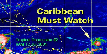
CFHC Talkback For News Story #55:
Newest Talkback: 07:08 PM 07-14 EDT

More on TD#2
09:58 AM EDT - 12 July 2001

Tropical Depression #2 is looking a litte different this morning, a little more concentrated and more tropical looking. I expect to see Barry today.

For it's future, it now appears as if it will head to the Eastern Leeward islands an a minor system. Many models have it entering and staying in the Caribbean. Climatology isn't favorible for it, and if it does creep north it'll have to deal with the mountains of Hispaniola.

It won't get much chance to strengthen over that Island. There is enough to suggest it could reach minor hurricane strength, so folks will need to watch.

Persistence again will be paramount. Beyond that, it still could effect Florida in some way next week if the stalled out front does not itself. But if it does go through the caribbean and Hispaniola it won't have enough to recover. In any case, the Caribbean needs to watch this one very closely for right now, and we may later depending on what path this thing takes. It probably won't touch us at all, but the chance is still there so I mention it.

TD#2! Barry later?


What about the models? The GFDL continues to want to toss this system in the trash, but moves it slowly toward the Caribbean. The MRF keeps it in the Caribbean and mostly south of the islands. The others all do various tricks with it, but climatology is a major factor in that. This is an early cape verde style system, and it has a lot going against it.

Watch!

Caribbean Hurricane Page - Updates from the various Caribbean Islands.

NRL Monterey Marine Meteorology Division Forecast Track of Active Systems (Good Forecast Track Graphic and Satellite Photos)

NASA GHCC Interactive Satellite images at:
[NAtl visible] (visible -- Daytime Only) [NAtl infrared] (infrared), and [NAtl water vapor] (water vapor)--Nasa source.
Defiant Visible Infrared More...
Other commentary at: Mike Anderson's East Coast Tropical Weather Center - Accuweather's Joe Bastardi - SCOTTSVB's Hurricane Update Center - Jim Williams' Hurricane City - Gary Gray's Millennium Weather - Even More on our Links Page

Some Forecast models: (NGM, AVN, MRF, ECMWF, ETA)
DoD weather models (NOGAPS, AVN, MRF)
AVN, ECMWF, GFDL, NOGAPS, UKMET

- [mac]


Show All Comments | Show Previous 21 Comments

Displaying Talkbacks #4 - #24 (of 24 total)

We he hold (#4)
Posted by: Joe Location: St.Petersburg, FL
Posted On 11:15AM 12-Jul-2001 with id (RQVNSNQXRNQPY*)


Thats a big question right now. Theres a chance it will but theres also a chance it won't. Never the less it needs to be watched, not writing this system off any time soon. 11 AM update still holding its same strength at 30 mph, with foward speed increasing a bit up to WNW at 20 mph so its moving. Other good points where brought up in the posts ubove about the western Caribbean and norhtern Gulf. So lots to watch. I was a bit concerned with the north gulf earlier in the week when I found out a front was coming all the to the Gulf Coast. But shear is is strong in both areas. So lots to watch this weekend.

td2 weakening? (#5)
Posted by:
doug Location: tampa
Posted On 12:37PM 12-Jul-2001 with id (VUNSTNVVNQVP*)


Current visible loop suggests that the convection, such as there is in TD 2, is being pushed west faster than the c of c, which may actually be exposed in the last frame. Not conducive for rapid development....the larger mass exiting N from Houndouras is more threatening visually, and visible suggests some rotation there. I agree be vigilant as the atmosphere is volatile right now. EDS.

TD #2 et al continued... (#6)
Posted by: Steve Location: Old Metairie, LA
Posted On 01:34PM 12-Jul-2001 with id (RPXNRTXNRSQNUX*)


Check out the MRF Day #6, 7 8 and 9. It looks like MRF is trying to put in a mid level anticyclonic circulation in the central gulf with an upper low over west-central florida. So early next week may also offer some exicitement as noted by the host.

Steve

Tropics heating up? (#7)
Posted by: Joe Location: St.Petersburg, FL
Posted On 02:41PM 12-Jul-2001 with id (VTNRTTNQNTU*)


Yeah took a look and it did point out a mid level anticyclone in central gulf. With upper low of west central florida. Another thing I find intresting is the convection down by Honduras whats your thoughs on theses features.
Thanks Joe

Cont... (#8)
Posted by: Steve Location: Old Metairie, LA
Posted On 03:55PM 12-Jul-2001 with id (RPXNRTXNRSQNUX*)


I'm not sure what all's going to happen. The satellite photos of the convection near Honduras actually shows outflow unless I'm looking to hard at it. But if I'm not, it definitely appears to be under a dome of high pressure.

Then no one's sure how far that front is going to sink into the Gulf. The best weatherman in New Orleans (Bob Breck) put a caution note on the front for early next week. IMHO, if a low was to form in the Gulf, you guys in peninsular Florida probably have more to watch than we do here in South LA. I would guess that all the model runs that come out tonight (12Z/8E/7C) will start accounting for both of these features.

Steve

Thanks (#9)
Posted by: Joe Location: St.Petersburg, FL
Posted On 04:06PM 12-Jul-2001 with id (RQVNSNQXRNTR*)


Thanks for the info. Of coarse I'am going over to the eastcoast for the week, which for some reason a storm gets going just about every time I leave.

welcome change!!!! (#10)
Posted by:
gary Location: jacksonville
Posted On 04:24PM 12-Jul-2001 with id (RPUNQURNVUNR*)


Finally we have some action brewing!!!! Why don't we have a little survey. We have so many people in jacksonville that do not think a storm will hit no matter how close it gets. How many of you hear this from around florida? Isn't kind of scary to think of what kind of loss of life we will have if one finally does hit and these people don't leave. What are the thoughts out there?

TD#2 NO LONGER (#11)
Posted by: Joe Location: St.Petersburg, FL
Posted On 04:29PM 12-Jul-2001 with id (RQVNSNQXRNTR*)


Well it has become a tropical wave and seems like it may have been killed by the shear and anticyclone to the east. I think regeneration will be slim. Other features are storms in western caribbean and thats about they only thing catching my immediate attention. But shear seems to be great in that area so no big threat as of now.

probably not finished (#12)
Posted by: HankFrank Location: Aiken, SC
Posted On 06:11PM 12-Jul-2001 with id (RPTNQQVNQVNQQX*)


okay, now that td 2 has been declassified, it's one of the better looking tropical waves you'll ever see. i guess that the nhc guys arent seeing the low level wind vectors they want to, but the mid-level circulation is obviously intact, so should there be another convective maximum tonight, this little sucker could totter back over the threshhold of classification. one thing's for sure, it's not going north of the islands now, heading due west for the barbados/martinique area. most of the models track a wave feature along at low latitudes from here on through 72hrs at very least.
anyhow, the central american cluster has decayed, no pressure falls in the region.. nothing overtly suggesting development. have to see if that refires. the models are forecasting some sort of low, possibly lows, to develop in the northeast gulf, or off the south atlantic seaboard over the weekend. every one has a slightly different take, so it's useless to speculate any further, just watch this trough as it settles in.. and see how far south the upper westerlies come to steer whatever might flare. i'd say chances are better than even that we arent done tracking active storms for the week.

Gary's subject cont..... (#13)
Posted by: Steve Location: Old Metairie, LA
Posted On 08:15PM 12-Jul-2001 with id (VSNQWNQWNQXP*)


Gary,

You guys in Jacksonville probably aren't in that great of a threat area. I've been out that way 7 or 8 times (my sister used to live in Maclenny), so this is what I think. In the unlikely event that a major storm would hit your area, everyone west of the St. John's will probably make out okay. Those not near the streams and rivers (i.e. St. George) would probably be okay too. What really helps you guys is the drainage of your sandy soil. Standing water and resultant long-lived floods are unlikely. And correct me if I'm wrong, but only those between the beaches and the St. John would really have to worry about a storm surge.

The other thing that protects Jacksonville is your positioning and climate. Historically, there have been very few major storms that have directly hit NE Florida and the Georgia coast. The only one I've ever experienced was when Fran tracked a couple hundred miles offshore. I watched trees (presumably from the Carribean) wash up in waves along Atlantic and Neptue Beach. It was too rough to swim that day. You also live in a relatively high pressure area for the south. I've often seen readings of 30.45 and higher on a normal day. New Orleans gets that kind of pressure measurement in the middle of winter after a major cold front has passed through and the daytime highs are in the 30's.

Anyway, I understand your problem. More than 50% of residents in the GNO area have never experienced a major storm. We caught the fringe of Andrew, and outside of Juan (85) and Florence (88ish), there haven't been that many powerful storms affect us. I was all of 1 when Hurricane Betsy hit in 1965, and that was a Cat 3. Obviously I don't remember it. But all the old timers think I'm crazy for wanting to experience a real hurricane first hand. I've assured them all that if it kicks my butt, I'm the first one out of town next time, but until I see for myself, I'm like the rest of the rookies - a healthy respect but more of a party attitude. I've got my hatchett, my first aid kit, my flashlights, water, non-perishables and of course, will have that ice cold beer.

Peace,

Steve

We're about to get hit with a line of strong storms... (#14)
Posted by: Steve Location: Old Metairie, LA
Posted On 08:25PM 12-Jul-2001 with id (VSNQWNQWNQXP*)


They've just entered the north end of Lake Pontchartrain from the Northshore and Southern Miss, so we've got some local action moving in. If I get a chance to log on later, I'll give you a report. If these don't die out, it looks like Lotsa [tm] lightning and maybe 1" or so. The line is moving South at 30, and it's about 20 miles north!

Steve

systems (#15)
Posted by: scottsvb (
http://communities.msn.com/HURRICANEUPDATECENTER) Location: tampa
Posted On 09:24PM 12-Jul-2001 with id (QRNWWNQTQNQXY*)


Well I predicted this one correct. I'm
2/2. Braging alittle I know, but anyways
to be serious this had too much dry air
around it and too its N. It shouldnt be
much until maybe early next week when it
gets to the W Carribean.
Also the system there now continues to
have a upper high around it, but its just
coming out of Honduras but still too close
to belieze to form. I give this a 3/10 so
slight chance.
Oh by the way, a movement of a system if
it weakens will move more west or just say
with the low level flow of winds. A system
strengthening usually pulls N due to the
coreallis affect, ( if i remember it word
wise), in any affect this is what happens
in the track. I ridge or trough ahead and
to the NW of the system will also determine
a quicker shift.

Kicking Steve's Butt (#16)
Posted by: Bill Location: Miami
Posted On 12:04AM 13-Jul-2001 with id (QTWNWPNXNQPQ*)


You do not know what you are asking for. I am sure that others have far worse stories than mine to tell, but I have been through four hurricanes that I remember. The first was Donna, at age four, and I have vivid memories of during and after. I also experienced Betsy, Cleo, and the worst of them all, Andrew, all of these in Miami.

You will forget all about your cold beer, and will be down on your knees praying to the God or gods, or whatever you do or do not believe in, when a 140+ mph sustained wind tries to take the roof and walls off the building you are in. It is a sound that can only be experienced, it can't be described. Listen to those old timers, they know what they are talking about.

Bill

JAX (#17)
Posted by: HankFrank Location: Aiken, SC
Posted On 01:37AM 13-Jul-2001 with id (RPTNQQVNQVNWV*)


the only jacksonville that ever gets hit is in north carolina. you can go a lifetime in jacksonville florida and not see a direct hit. the georgia coast is much the same.. strange thing is, not many people live there. most of the barrier islands are national preserve... people decided galveston and miami would make safer places to settle.
the last really bad hurricane to hit the region was in october 1898. several storms hit in the 1800s, but only a couple hit between st augustine and beaufort in the 1900s (1911, 1947, 1979.. none very strong). if you go by 19th century averages, about five more should have hit in the last century... wilmington has been taking a few for the team.

SAY GOODBYE AND GOODLUCK (#18)
Posted by: joe Location: tampa florida
Posted On 06:18AM 13-Jul-2001 with id (RTNYRNRQVNUT*)


Dont think this will make a comeback,not enouff punch to get it going lets try nextweek

Goodbye (#19)
Posted by: Joe Location: St.Petersburg, FL
Posted On 12:23PM 13-Jul-2001 with id (VTNRTTNQNUX*)


There won't be a regeneration with this wave or former TD#2. The only thing to watch will be the Gulf, where a very unusual cool front will make it to the northern and central gulf and back into central florida. Need to keep an eye open...

Kicking My Butt.... (#20)
Posted by: Steve Location: Old Metairie, LA
Posted On 02:06PM 13-Jul-2001 with id (RPXNRTXNRSQNUX*)


Bill,

I should have qualified my post by saying that I'm not sure I want to ride out a 4 and definitely not a 5 in New Orleans. Most of the urban flood models put the City under anywhere between 16 and 25 feet of water. What's worse, is since we live in a bowl, there isn't anywhere to pump the water once it tops the levees to the north, east or west of town.

I suppose I'm lucky that I live on the Metairie "Ridge" which is a towering 3 feet above sea level. Coupled with the fact that my house is another 4 feet above that, that leaves me nothing but a rooftop view of the action. I guess I'd prefer a solid Cat-2 to see firsthand. But with a 4 or 5? I can't even begin to imagine the idea of sustained winds in excess of hurricane strength for 12 or more hours. That's terrifying.

Do you have any specific memories you want to share on any or all of the four storms you mentioned? My earliest memory was of Hurricane Camille (1969). I remember my mom walking me to bed with a hurricane candle and telling me that everything would be fine in the morning. Outside of our temporary loss of power and a few strewn leaves and branches it was. We were about 30 miles west of the edge of devastation. For Andrew, we had sustained winds in the 20's and 30's with some gusts into the 40's and 50's. We picked up a couple of inches of rain.

The most inconvenient storm we had was Frances back in 97 or 98 which dumped copious amounts of rain on the City in a very short time. That storm was centered around Brownsville, but we got caught under several training bands. It was somewhat similar to what happened this year for Allison, but the rain came down much harder in a much shorter period of time. All of the arteries leading out of downtown were flooded, and stalled cars littered the roads.

Steve

RE Jacksonville (#21)
Posted by: JJ
Posted On 02:35PM 13-Jul-2001 with id (RPUNQXXNQYSNQWV*)


NE. FL and GA are also located in a region where hurricanes typically recurve; when they're in the vicinity, they're usually paralleling the coast. The fact that the coast recedes westward, rather than projecting eastward like the Carolinas, is also a factor.

Though some may disagree, I think that the safest place to live on the coast in the whole southeast--if you don't want to deal with tropical cyclones--is the coast from NE FL to the SC border. I'd also say that the TX coast south of Corpus is almost as good.

Memories (#22)
Posted by: Bill
Posted On 07:42PM 13-Jul-2001 with id (QTWNWPNXNQPU*)


Steve,

Yes I do have a few, and some stories my mom told me about the 1935 hurricane, when she was only five.

During Hurricane Donna, we lived in an old Florida frame house with porches all around, and metal shutters. I was not quite four years old, but remember it like it was yesterday. I remember the rain, wind and everything else, hammering on those shutters for a long time. I remember my mom giving me something "to help me sleep", a clear liquid in a big old silver plated spoon, but it didn't work. I also remember my brother, all of 2 years old, crying and crying and pointing at his shoes. He wanted to leave!

We had been down to Flamingo the week before on a family trip. I had left some cherished item (can't remember now, a teddy bear, or something) and my dad decided that we'd go down and try to find it. Big mistake. As we drove further and futher down, the devastation increased. I remember my mom crying. It was really bad. Anyone that knows about Donna knows that the entire tip of the Florida peninsula, which is mostly in Everglades National Park, was flattened. The entire motel was blown clean through. No windows or doors left, and everything that had been in the rooms was inland all scattered among what little was left of the trees, along with dead birds and all kinds of other debris. I can see still see the white of the matresses from the beds in the motel hanging from what was left of the trees, and the motel without any windows or doors.

Another thing I remember was Betsy. I was in elementary school. The weather had already started to get bad, and for some reason they waited to close the school. But it was just after lunchtime, and all the parents were called. We were waiting in the normal pickup area when we started hearing shouts. The teachers herded us all back into the building, but as I looked back out I saw my first tornado. It was tearing large branches from trees, and there was already some debris in it, it headed on away, but they kept us inside until our parents came to get us. If I remember right, that storm was not as bad as others overall when it came to damage in our immeidate neighborhood, unlike Cleo that flattened our entire two acres. What I remember of Cleo was the cleanup. It took a work crew of 5 over a week to clean up the mess of downed trees. And for a kid it was great fun.

I am sure that my early exposure to some really awesome weather is why weather still fascinates me today, and why I like this site.

Bill

Wow (#23)
Posted by: Steve Location: Old Metairie
Posted On 01:14AM 14-Jul-2001 with id (VSNQWNQWNQUX*)


Thanks Bill.

I'm not sure how my interest got piqued, but I do have a theory. My earliest rememberances were all dreams of tornados. Usually small ones - either black or electric. You could catch them, but there would always be more. When I was about 18, I had one where I was floating in the gulf during a mammoth hurricane. A wave picked me up maybe 150 feet and crashed into the LA shore. Fortunately, I woke up :) I haven't had so many in my adult years until this past Monday when I was out of town in Lafayette, LA. I was in NY with my kids and several friends. Large black waterspouts/tornados just kept forming and crashing into the hotel I was in.

Now I don't believe in reincarnation so I figure that something affected my psyche when I was very young. Another odd thing is that the dreams never really are quite nightmares. They're scary, but never turn into nighmares. I suppose it's possible that Betsy for me (17 months) must have meant something. My dad's story was that we had a pretty bad night in Gentilly (NE New Orleans). He took us to the local Catholic School gym 3 blocks away, but it was very hot. My older sister and I threw up, so he brought us back home. The next day, the water backed up into the neighborhood and started to get into the house. A rescue boat/truck picked us up and brought us back to the shelter. She was our last direct hit from a major storm. There are horror stories about clawmarks in ceilings down in St. Bernard Parish and Chalmette (SE of NO) where the water rose very high. There has always been speculation here that the Army Corps of Engineers blew up one of the levees in order to save the city. This has never been substantiated, but many people who heard a massive explosion swear by it. Another early memory was the May after Camille on the Gulf Coast. Biloxi and Ocean Springs was our general destination for weekend vacations back then. It's funny that you mentioned being in Flamingo. I'll never forget the site of the former Flamingo motel in Gulfport. For years, all they had was a fenced off pool with a "Keep Out" sign. It's a place my mom says we used to stay before it was obliterated. But for many years, all we ever had were storms that threatened and then curved away. This includes Georges which tore up coastal MS a couple of years ago. It also includes Opal which caught us in a pressure gradient and gave us sustainted winds between 30 and 50 for several hours - under BLUE SKIES.

Thanks again for passing on some of your stories. They get the blood flowing. I'll tell ya, New Orleans gets really weird when storms approach. It's exciting in an odd way seeing people react. I suppose it's because it's one of those times when everyone is in the same boat. It doesn't matter if you're rich or poor, black or white when nature comes calling. A positive recent sign for N.O. at large was Georges. It was estimated that 2/3 of the Metro area evacuated. This caused tremendous tie-ups on the I-10. It took some people up to 8 hours to get to Baton Rouge which is about 80 miles NW of here. They've since carved out turn around lanes so all but one lane on both sides of the I-10 will head outbound in both directions. This should help as it takes 72 hours to totally evacuate my city. Hurricane Andrew hadn't even hit you guys 72 hours before it hit St. Mary Parish. And there is no way anybody is going to shut down New Orleans when a storm is in the Atlantic or south of Jamaica.

Thanks again,

Steve

Re Dreams (#24)
Posted by: JJ
Posted On 03:08PM 14-Jul-2001 with id (QURNQVSNRPQNRPV*)


I've had several vivid dreams about hurricanes and tornadoes...always during hurricane season, not surprisingly.


Show All Comments | Show Previous 21 Comments


Return to Central Florida Hurricane Center Main Page