Clark
Meteorologist
Reged:
Posts: 1710
Loc:
|
|
11PM
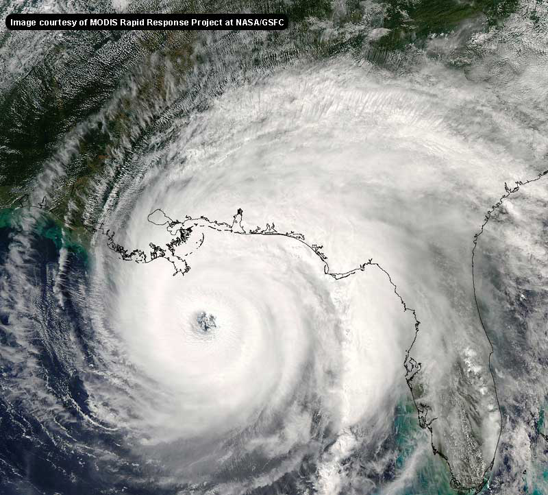
Katrina remains a hurricane, and is now over the Florida Everglades. The current forecast track takes it a little more toward the west and southwest and out into the gulf early tomorrow morning, and then eventually turning north and toward the Florida pnahandle. The cone of error puts it close to the west coast as well, so some rain may be felt for the next few days.

(We and are looking for feedback on maps, let us know here)
It's moved a bit quicker across the state that the earlier forecasts suggested, and further south and west. This will enable the storm to be out over the Gulf quicker, and although the Everglades can't sustain a storm, it can keep it from weakening as rapidly as it would over dry land. That seems to be happening with . If the core holds together until it returns into the Gulf it could reach major hurricane status when it moves back over the water. In fact, even some of the usually more conservative models bring it to major hurricane status when it is back into the Gulf.
Katrina has been one of the more interesting storms to track in quite a while, and probably will remain so over the next few days as attention turns toward the Panhandle and northern Gulf coast.
See more detailed discussions below in the Blogs from Clark, etc.
9PM Update
Katrina remains a hurricane at 9PM, it's center is very close to the National Hurricane Center office, and continues on it's west to west southwest motion.
Power is out across the area, including in Metro Miami.
8PM Update
Strong Tropical Storm/Minimal Hurricane Conditions were felt along the landfall area, including a 90mph wind recording in Miami. One confirmed fatality has occurred on the roads of the area with another unconfirmed fatality being reported so far. The storm is enough inland to start weakening now, and it's showing some signs of that.
Beyond tonight, it may slide a bit more west southwest and emerge back in the Gulf around Naples. After that, it has a pretty good shot at restrengthening and probably bending back toward the Panhandle or Northwestern Florida. The current track would suggest near Apalachicola. It will take some time for to cross the state. Sometime late tomorrow. We'll be watching it all night. Let us know if you are in the affected areas in the Situation Report topic.
7PM Update
Hurricane has made official landfall between North Miami Beach and Hallendale as an 80MPH Category 1 hurricane.
11PM Update
6PM Update

This radar image live
The center of is still just offshore, and amazingly seems to be drifting a bit to the south or stalling, still increasing in strength. This is very interesting situation developing here. Wobbles you usually ignore, but when the center is within 20 miles of land, it's a bit different.

It appears to still be strengthening and slowing even more.
More updates to come soon.
Jim Williams, from Hurricane City and West Palm Beach, will be doing his live audio show likely tomorrow as approaches on hurricanecity. Listen here
Ross from Suncam.tv is streaming video and webcams from the landfall area
Marc Sudduth will likely also be in the area see his live streaming video and audio here
Reply and let us know of other links.
Event Related Links
General Links
Report conditions in your area/read other's reports at this link (registration not required).
StormCarib hurricane reports from observers in the Islands
Caribbean Island Weather Reports
Color Sat of Gulf
RAMSDIS high speed visible Floater of Storms
Emergency Management/County info
Broward County Emergency Management
Palm Beach County emergency managment
Miami-Dade County Emergency Management
State of Florida Division of Emergency Management/floridadisaster.org
Katrina
 
Google Map plot of
Visible Floater Satellite of
Water Vapor Floater of
Visible Satellite Floater of with storm track overlays
Animated model plots of
Spaghetti Model Plot of from Colorado State
Bahamas Radar
Florida Keys Long Range Radar Loop
Miami, FL Long Range Radar
Melbourne, FL Long Range Radar
Forecast Discussions for (Show All Locations):
Miami, Key West, Melbourne
Invest 97L

NRL-Monterey Satellite Data on 97L
METEOSAT-8 imagery over Europe & Africa from the Univ. of Wisconsin
Animated model plots of 97L
Edited by MikeC (Mon Sep 19 2005 03:33 AM)
|
ralphfl
Weather Master
Reged:
Posts: 435
|
|
http://euler.atmos.colostate.edu/~vigh/guidance/atlantic/early2.png
New 18Z runs are out
|
Justin in Miami
Storm Tracker
Reged:
Posts: 269
Loc: Ft. Lauderdale, Florida
|
|
Greetings from Ft. Lauderdale! Does anyone think this will push a higher Category than a 1? Looks like the dry air might save the day down here...things sure are picking up though....sparks on powerlines in my neihborhood....
|
ralphfl
Weather Master
Reged:
Posts: 435
|
|
i dont see it as it is way too close to land to get to Cat 2 but you can't say 100% but unlikely.
|
SirCane
Storm Tracker

Reged:
Posts: 249
Loc: Pensacola, FL
|
|
Notice how these models are shifting to the West now more toward Mobile. Here we go again. , . Now . Why am I not surprised. It's Hurricane Alley here these days in the Mobile/Pensacola region. 
--------------------
Direct Hits:
Hurricane Erin (1995) 100 mph
Hurricane Opal (1995) 115 mph
Hurricane Ivan (2004) 130 mph
Hurricane Dennis (2005) 120 mph
http://www.hardcoreweather.com
|
Wanna-Be-Storm-Chaser
Weather Hobbyist
Reged:
Posts: 90
Loc: Deltona, FL
|
|
One model has it going like , sort of. Not even making it to the gulf. How is this possible?
--------------------
I survived Jeanne, Charley, and Frances
|
Ryan
Storm Tracker

Reged:
Posts: 281
Loc: Long Island, NY / Stuart, FL
|
|
The fsu model plots are interesting. They have going over south florida then riding the west coast of florida thn crossing florida again and exiting by the FL/GA border line. Then if you look at the 120 hours on the models they have invest 97L developing being justt east of Bermuda, then there is a system in its path right between the lesser antilles and the cape verde islands and a little northward, AND a system coming of the African coast. At 120 hours they all look to have a pressure of 1000-1008. Should Be interesting once we are finally done with wether that man another eastern turn back over florida, or Pensacola-Mobile-Gulfport 2nd landfall.
--------------------
2006 Atlantic Season Summary:
Bad, But Not AS Bad.
Life's a Storm, Watch Your Back
|
Clark
Meteorologist
Reged:
Posts: 1710
Loc:
|
|
Don't get down yet...it's just one set of model runs and things can and do change with these storms. As noted before, however, slow variations in forward motion are going to result in pretty big deviations in the track. The trough appears to be well-forecast in terms of when, where, and how strong, leading to the forecast largely becoming one of timing (IMO). Note that unless gets really strong, it'll have a natural tendency as a larger storm to move further nortward than perhaps expected...not a lot, of course, but something to consider if anyone thinks the storm will become a strong/major hurricane.
--------------------
Current Tropical Model Output Plots
(or view them on the main page for any active Atlantic storms!)
|
ralphfl
Weather Master
Reged:
Posts: 435
|
|
Maybe a old model but i see none right now that show that1 The same line as always LINK! would help.
Edited by ralphfl (Thu Aug 25 2005 08:36 PM)
|
Wanna-Be-Storm-Chaser
Weather Hobbyist
Reged:
Posts: 90
Loc: Deltona, FL
|
|
look at the model at the beginning of this thread. There is one track showing that.
--------------------
I survived Jeanne, Charley, and Frances
|
ralphfl
Weather Master
Reged:
Posts: 435
|
|
Clark when is it going to have time to get that? its about to hit land for over a day then when out over the gulf by the time it gets to cat 2 or whatever it will be way north or west already no?
|
ralphfl
Weather Master
Reged:
Posts: 435
|
|
that was a old run from early today.None of the latest models have that in it.Does not mean it cant but none are showing that right now.
|
ralphfl
Weather Master
Reged:
Posts: 435
|
|
http://www.wunderground.com/tropical/at200512.marine.html
5PM coming out At 5 PM EDT...a tropical storm watch has been issued for portions
the Florida West Coast from north of Longboat Key to Anclote Key. A
tropical storm watch remains in effect for the east-central Florida
coast from north of Vero Beach to Titusville... including all of
Merritt Island. A tropical storm watch means that tropical storm
conditions are possible within the watch area... generally within
36 hours.
Hurricane center located near 26.1n 79.9w at 25/2100z
position accurate within 15 nm
|
Susan in Jupiter, FL
Verified CFHC User
Reged:
Posts: 18
|
|
When exactly is it "legally" considered to "make landfall"? Because it sure looks like the western side of the eye wall is on land at this time.
--------------------
Susan in Jupiter, FL Survived:
Andrew, Irene, Charley, Francis,
Ivan, Jeanne, Katrina, Wilma
|
ralphfl
Weather Master
Reged:
Posts: 435
|
|
present movement toward the west or 265 degrees at 5 kt
estimated minimum central pressure 985 mb
eye diameter 10 nm
Max sustained winds 65 kt with gusts to 80 kt.
|
ralphfl
Weather Master
Reged:
Posts: 435
|
|
the new track is a little more west but not much only out to 85 west which is about .5 more then the last which was out to 84.5 so they did not change much but did speed it up some.
|
Ryan
Storm Tracker

Reged:
Posts: 281
Loc: Long Island, NY / Stuart, FL
|
|
it seems as if wants to stop at the cities if shes in town..cities like Ft. Lauderdale, Ft. Meyers, and the if she follows Skeeto's maps Tallahassee, the capital. what do peopel think of my post further up the board about FSU.
--------------------
2006 Atlantic Season Summary:
Bad, But Not AS Bad.
Life's a Storm, Watch Your Back
|
Rick on boat in Mobile
Weather Drama Guru

Reged:
Posts: 161
|
|
and it wouldn't suprise me if she heads a little due south of west. Interestingly, if she stays a bit more south...and exits south of Everglades City...she escapes more land than if north....
which would lead to less weakening, etc...
models should punch somewhat left now....
|
Storm Hunter
Veteran Storm Chaser

Reged:
Posts: 1370
Loc: Panama City Beach, Fl.
|
|
URNT10 KNHC 252036
97779 20304 50253 82700 73200 04024 65701 /5761
RMK AF300 WXWXA 05082520300 OB 01
this plane flew all the way to south fla... and then had computer problems and had to abort at midnight.... looks like they are on a trainning mission....testing equipment near mobile right now.....gettting ready for late friday night? should be in GOM by then
--------------------
www.Stormhunter7.com ***see my flight into Hurricane Ike ***
Wx Data: KFLPANAM23 / CW8771
2012== 23/10/9/5 sys/strms/hurr/majh
|
Clark
Meteorologist
Reged:
Posts: 1710
Loc:
|
|
Rick, if that happens further, then perhaps. But, they've already got the westward motion at a slightly faster speed into their output and have already shifted somewhat west. It still should slow down over Florida -- it is entering a col region and about the only thing moving it right now is inertial momentum and reorganization wobbles -- but given the slightly faster track, the decided to shift the 5p track a bit further to the left. We'll see if this is a trend or not; given the wishy-washy tendency of the models, chances are that it might not be.
--------------------
Current Tropical Model Output Plots
(or view them on the main page for any active Atlantic storms!)
|


 Threaded


