MikeC
Admin
Reged:
Posts: 4544
Loc: Orlando, FL
|
|
8:50PM EDT Update 24 September 2007
96L (The wave in the eastern Atlantic Becomes Tropical Depression 12, after a burst of activity tonight and dvork t numbers (Satellite windspeed estimages) that support it. Advisories should begin at 11PM EDT. It is most likely to never affect land.
More to come at 11PM.
Original Update
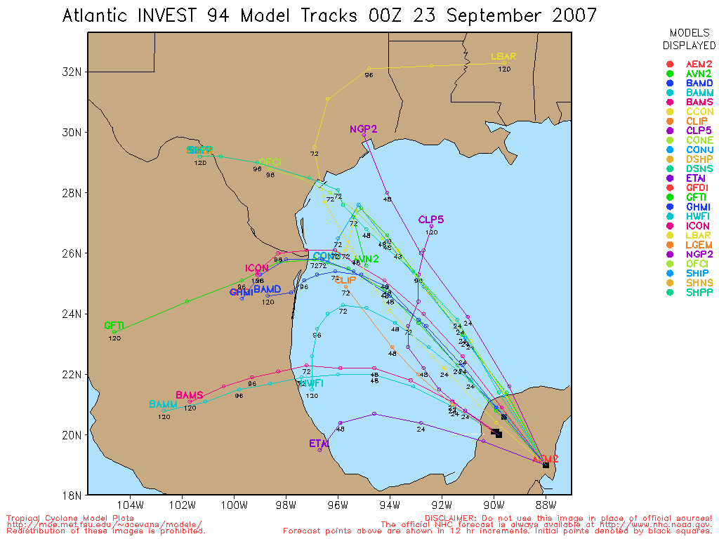
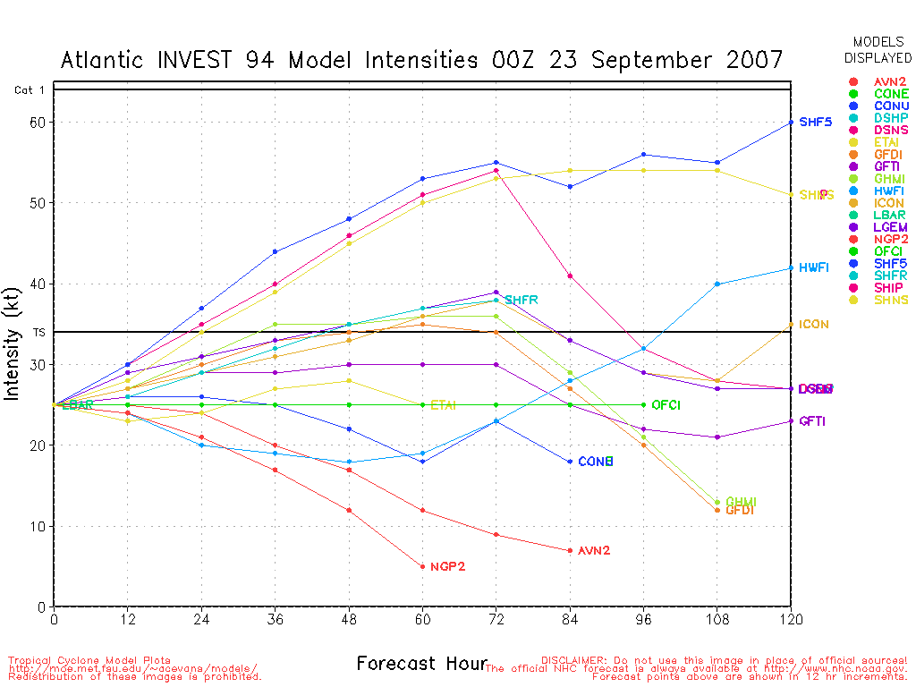
Today two systems are looking better for development, the most immediate concern in the disturbance in the Gulf of Mexico (94L). It may form as early as 5PM tonight into a depression. The current model runs have it moving more westward or even slightly south of due west toward Mexico (not likely for US landfall), and because of the upper air situation, likely no more intense than a Tropical Storm.
96L in the far eastern Atlantic may form tomorrow or the next day as well. Right now it's starting to look better, but the overall circulation remains a bit too broad to be classified.
97L near the Windwards is looking a little better today, but likely won't develop before it gets to the islands, still it must be watched.

Jerry has weakened into a depression and will turn soon.
More to come soon...
Chances for Tropical Development of Disturbance in the Gulf (94L) In Next 2 days (Lounge discussion thread here )
Code:
(forget it) 0 1 2 3 4 5 6 7 8 9 10 (sure thing)

            [--------------*-----]
Chances for Tropical Development of Wave in Far Eastern Atlantic (96L) In Next 2 days (Discussion thread here.)
Code:
(forget it) 0 1 2 3 4 5 6 7 8 9 10 (sure thing)

            [----------*----------]
Chances for Tropical Development of Wave East of the Caribbean (97L) In Next 2 days (Discussion thread here)
Code:
(forget it) 0 1 2 3 4 5 6 7 8 9 10 (sure thing)

            [------*-------------]
Martinique Radar
|
punkyg
Weather Watcher

Reged:
Posts: 44
Loc: sanford, florida
|
|
What what what! i am shocked that yall are only paying attention to the area in the gulf. what about 96L its gonna develop too you know.
|
MikeC
Admin
Reged:
Posts: 4544
Loc: Orlando, FL
|
|
Quote:
What what what! i am shocked that yall are only paying attention to the area in the gulf. what about 96L its gonna develop too you know.
Two things, the one in the Gulf is closer to land, 97L is closer to windwards, 96L may develop tomorrow. It's looking better today, but still a bit too broad a circulation right now (If you look at water vapor satellite loops you can see what I mean). Tomorrow it should be good to be a depression or storm, convection around the center (which is what I'm looking for looks like it may be starting to occur). 96L probably will get sheared up ahead too, which means I don't think it'll become a hurricane at least for a while.
97L is nearing the islands, but isn't looking as good.
The tropics are interesting to watch right now, but there isn't anything all that worrisome about what's going on now.
|
Thunderbird12
Meteorologist
Reged:
Posts: 644
Loc: Oklahoma
|
|
The upper pattern in the Gulf is a little convoluted right now, but it appears that 94L flared up in a narrow zone of difluence aloft (which aids convection) underneath a narrow ridge of high pressure that is sitting between a weakening upper trough over south Texas and a developing upper low over Florida. There is evidence of anticyclonic outflow in the cloud pattern, but it is also still plainly being sheared from the south at some level.
It certainly looks the part of a depression at the moment, but will probably wait to see if it can maintain its current level of organization for awhile (and probably wait for a plane to get in there) before classifying the system. It actually looked better about 1-2 hours ago, but the convection that flared up near the center earlier has died down for the moment.
|
OUSHAWN
Weather Guru
Reged:
Posts: 101
Loc: Clear Lake,Tx
|
|
Actually, I don't think anyone knows where 94L will go. I've seen quite a few models that just want to have it spin around in the GOM for days. The steering currents are extremely weak and that doesn't bold well considering the shear is suppose to lighten up and the water is extremely warm out there. It almost looks like 94L may be trying to reform a new center under the deep convection or something...not sure yet.
Shawn
|
BLTizzle
Verified CFHC User

Reged:
Posts: 13
Loc: Eufaula, AL
|
|
The center of 94L seems to be moving under the convection a little better. Looking at the visible it seems the shear might have picked up a bit based on the way the cloud tops are a big more ragged than earlier. Then again, could be diurnal minimum. It'd be nice to have some stronger steering currents to get a better hold on where its gonna go. The shear's supposed to let up a bit and with no steering currents, there are some models that have it just meandering around.
Convection continues to fire on 97L, but its got some mean shear to deal with shortly. If it can survive that then it might have a chance.
96L looks healthy, as it has for most of its life. Looks like the low might be trying to squirm its way down to the surface at around 9.5N 34W. Right smack dab in the middle of all the convection. Nice blow up of thunderstorms in the region too, so I wouldn't be surprised. Don't think it'll be long before it gets classified if that is indeed happening.
|
Storm Hunter
Veteran Storm Chaser

Reged:
Posts: 1370
Loc: Panama City Beach, Fl.
|
|
looks like they will make one more adv. pkg for Jerry...
per 5pm
TD Jerry Discussion:
SATELLITE IMAGES INDICATE THAT THE CENTER IS NOW NEAR THE SOUTHERN
EDGE OF A SMALL MASS OF DEEP CONVECTION. THEREFORE WE NEED TO
MAINTAIN THE SYSTEM AS A TROPICAL CYCLONE FOR THE TIME BEING.
HOWEVER A STRONG COLD FRONT IS NEARING THE AREA...AND THE
ASSOCIATED VIGOROUS CYCLONE SHOULD ABSORB JERRY IN 12
HOURS OR SO.
--------------------
www.Stormhunter7.com ***see my flight into Hurricane Ike ***
Wx Data: KFLPANAM23 / CW8771
2012== 23/10/9/5 sys/strms/hurr/majh
Edited by Storm Hunter (Mon Sep 24 2007 08:52 PM)
|
cieldumort
Moderator

Reged:
Posts: 2305
Loc: Austin, Tx
|
|
This could be more than slightly interesting. Just refreshed and they had No Names up on all three Invests, starting with 96 as 12L.
edit-
I'll amend that to add that, contrary to what that might normally imply, convection in both 94L and 97L has been weakening with time while hitting the diurnal minimums, and 97 has a date with the Graveyard & shear. Overall, they appear structurally fairly intact, so it will become informative to see if they experience an overnight blossoming of deep convection.
Edited by cieldumort (Tue Sep 25 2007 12:59 AM)
|


 Threaded


