MikeC
Admin
Reged:
Posts: 4544
Loc: Orlando, FL
|
|
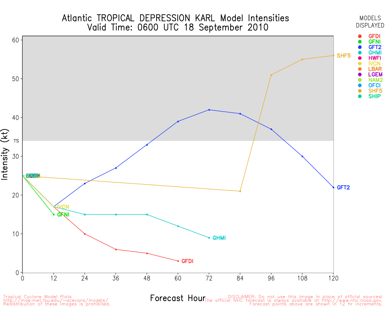
Karl made landfall yesterday afternoon as a weakening hurricane, which probably kept the worst away, it never made it to category four, thankfully. But damage was done around Veracruz.
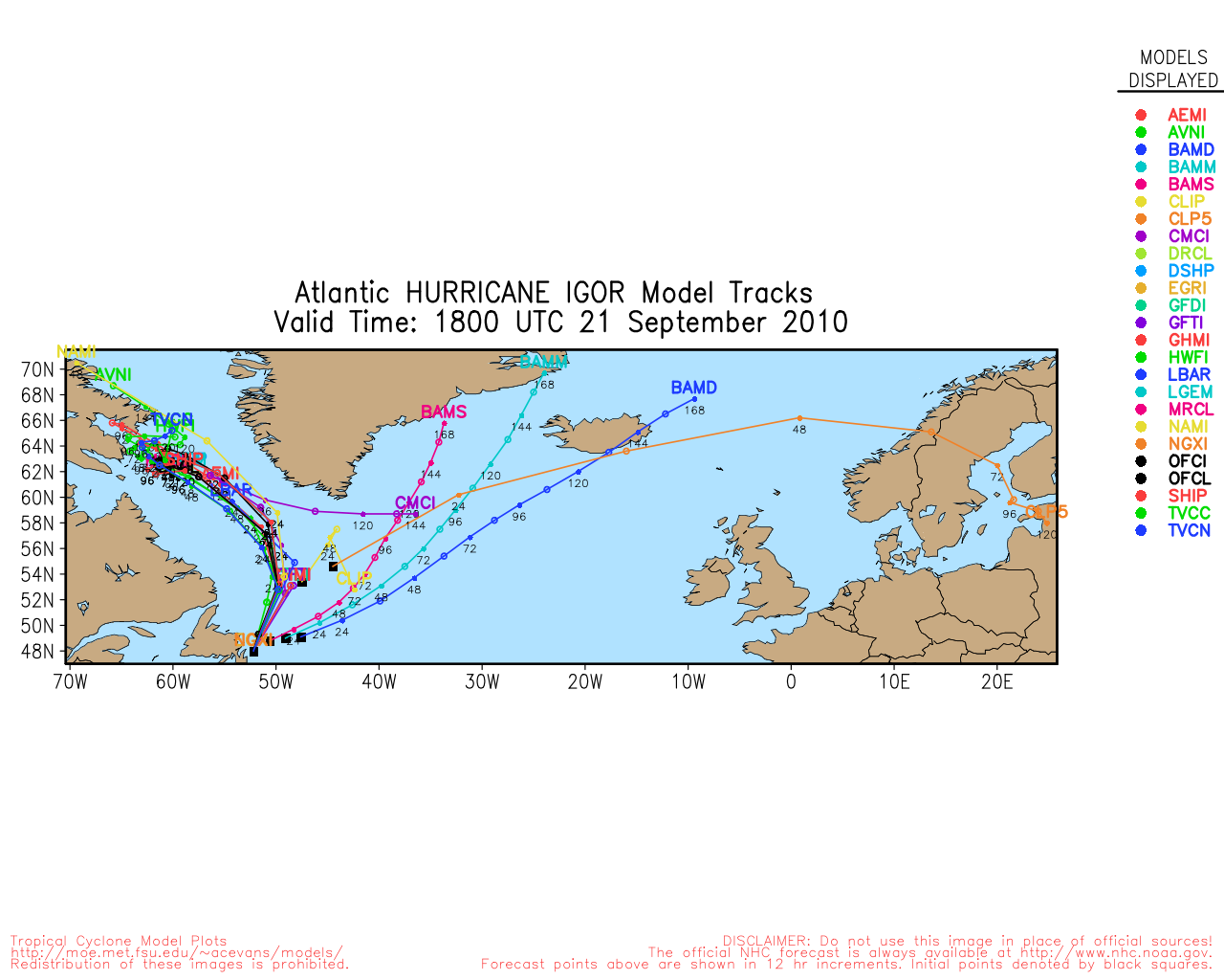
Bermuda may have to deal with a direct hit from Igor Monday, and tomorrow conditions will degrade. Hurricane Warnings are up for the island, and a lot will depend on how close the core of Igor gets, the forecast is within 10 miles of the island, and a lot will depend on when the more easterly motion begins.
Bermuda should prepare for a direct hit from a major hurricane. The last hurricane Bermuda dealt with directly was Fabian in 2003.

The first sign of Igor may be some increased winds late tonight, but nothing bad until late tomorrow into Monday. It means Sunday will be windy all day winds with Igor large size, but the worst of it will be mostly overnight Sunday into Monday.
Most buildings in Bermuda are very well constructed, but storm surge may be an issue in some place.
Surge has the potential to flood large sections of the island. Those in Bermuda should prepare today while the weather is still good enough to work.
Bermuda Radar Recording of Igor Approach (flhurricane)
Mark Sudduth over at hurricanetrack has a video stream from Bermuda
Another live stream from Bermuda
A new wave, in the far eastern Atlantic has been designated 94L and likely will stay out to sea.
Update - 2:45PM CDT, Friday 17 Sept 2010
MAJOR HURRICANE KARL MADE LANDFALL ON THE SOUTHWEST GULF COAST
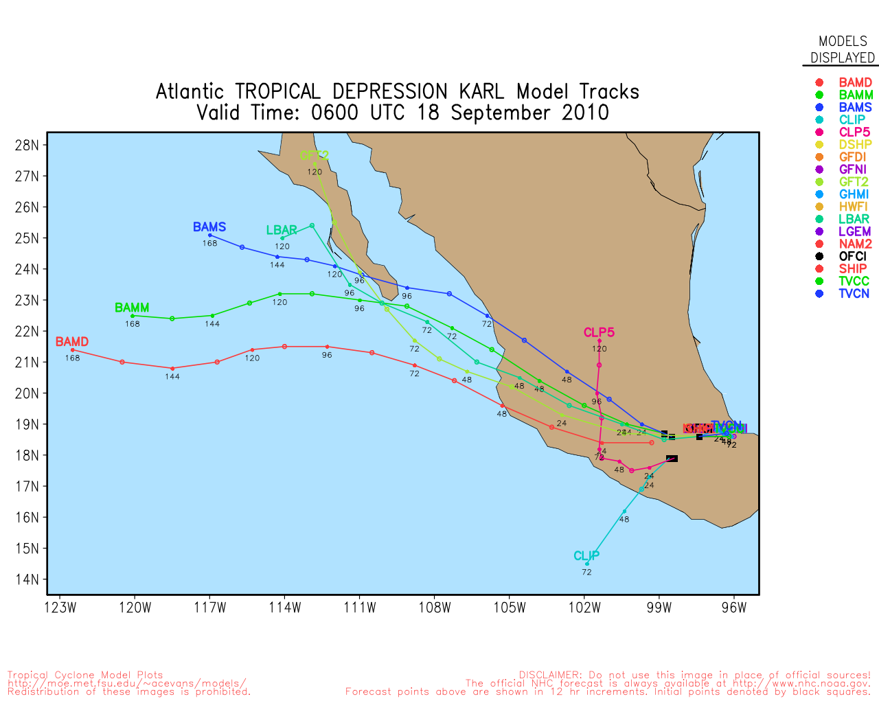
Karl made landfall on the coast of Mexico in the Bay of Campeche at 11:30 AM CDT as a major hurricane, with maximum sustained winds estimated to be 115MPH. As of this time, Karl is still a very dangerous tropical cyclone, and extremely heavy rainfall and flooding are likely now occurring. In addition, potentially deadly storm surge of 12 to 15 feet above normal levels may very well be underway along and near the coast within and to the north of the center.
Update - 5:45AM EDT, Friday 17 Sept 2010
Hurricane Karl was upgraded overnight to a major Hurricane, a category 3, and forecast to strengthen to 140MPH (Cat 4) by tonight. Rapid intesification happened in the Bay of Campeche and now Mexico (and a lot of us) will likely be caught by surprise. Those in coastal areas should evacuate while there is time (and there isn't much). This level of a hurricane was not forecast a few days ago, but a hurricane watch and warning were issued and is why to treat hurricane watches and warnings seriously.
Landfall will be late in the afternoon or early Evening.
Best of luck and prayers to those in that area of Mexico, they are about to get pounded.
The town most in danger from Karl is Laguna Verde, but Karl is large enough to cause problems a good distance away too.
Laguna Verde is home to Mexico's largest nuclear power plant.
Points just north of the landfall will receive the absolute worst of it. Veracruz will likely see some damage, but not the worst. Storm Surge will be a tremendous issue (!2-15 ft at and north of the landfall point).
Veracruz Webcam
Veracruz TV

Meanwhile Hurricane watches are now up for Bermuda as Igor is expected to be very close or over the island late Sunday into Monday morning.
Alvarado, MX Radar Recording of Karl Approach
Update - 11AM EDT, Thursday 16 Sept 2010
Just a short update to note that Karl is now a Hurricane - located about 100 miles west of Campeche, Mexico, moving west at 10 knots. Karl is now forecast to make landfall Friday evening near Poza Rica de Hidalgo, Mexico as a strong Cat II Hurricane - and notes that landfall as a major hurricane is possible.
ED
Weather Conditions at Poza Rica
Weather Conditions at Tampico
Weather Conditions at Veracruz
A HURRICANE WARNING IS IN EFFECT FOR...
* THE COAST OF MEXICO FROM PALMA SOLA TO CABO ROJO
A HURRICANE WATCH IS IN EFFECT FOR...
* THE COAST OF MEXICO NORTH OF CABO ROJO TO LA CRUZ
A TROPICAL STORM WARNING IS IN EFFECT FOR...
* THE COAST OF MEXICO NORTH OF CABO ROJO TO LA CRUZ
* THE COAST OF MEXICO SOUTH OF PALMA SOLA TO VERACRUZ
Original Post - 6AM EDT, Thursday 18 Sept 2010
Tropical Storm Karl is back over water in the Bay of Campeche this morning, and Hurricane Watches are now up from Bara de Nautla south to Palma Sola in Mexico. Karl is Forecast to landfall as a hurricane south of Tampico, but anyone in the watch area should prepare for it. Arrival time is the pre-dawn hours on Saturday.
Igor has completed it's first Eyewall replacement cycle and kept itself a category 4. It has another shot to strengthen before weakening. The forecast track remains dangerously close to Bermuda, so folks there need to probably start preparing for good possibility that there may be core of a very strong hurricane passing near or over the island.

Igor's convection is dragging toward the south, and the north side is a bit weaker looking this morning, but the core remains very strong. Igor will not affect the us mainland directly. Only higher surf and more potential for rip currents. Bermuda is looking more likely that it won't be able to avoid impact.
Julia has weakened some since yesterday, back to a category 2. It will remain out to sea.
Buoy in the path of Igor (will be at closest point in about 24 hours)
Alvarado, MX Radar Recording of Karl Approach
|
JoshuaK
Weather Guru
Reged:
Posts: 159
Loc: Lakeland, FL
|
|
Igor sure is a growing boy. Bermuda is not going to have a fun time in a few days. Karl is looking impressive, looks like he might be trying to build up a small eye. He's a small boy, which depending on where he hits could be good or bad for Mexico, since small systems are perhaps more capable of rapid intensification than larger systems, although the area affected would be less. Julia is losing a lot of convection.
|
Random Chaos
Weather Analyst

Reged:
Posts: 1024
Loc: Maryland
|
|
This just came out:
"RECENT DATA FROM AN AIR FORCE RESERVE RECONNAISSANCE AIRCRAFT
INDICATE THAT TROPICAL STORM KARL HAS MAXIMUM WINDS OF NEAR
65 MPH...100 KM/HR...AND A MINIMUM CENTRAL PRESSURE OF 986 MB...
29.12 IN."
http://www.nhc.noaa.gov/text/refresh/MIATCUAT3+shtml/161158.shtml
|
WeatherNut
Weather Master
Reged:
Posts: 412
Loc: Atlanta, GA
|
|
Looking at the Atlantic:
http://www.ssd.noaa.gov/goes/east/tatl/loop-vis.html
Looks like Julia is barreling towards Igor and should get pretty close if that motion continues. Does the Fugiwara effect cause storms to pivot counter clockwise around a middle point or is it the other way around? At present motion it looks like they will run into each other
--------------------
Born into Cleo (64)...been stuck on em ever since
|
Ed Dunham
Former Meteorologist & CFHC Forum Moderator (Ed Passed Away on May 14, 2017)
Reged:
Posts: 2565
Loc: Melbourne, FL
|
|
From the Glossary on the Fujiwhara Effect:
"The tendency of two nearby tropical cyclones to rotate cyclonically about each other."
Its a rare event in the Atlantic. If two storms get too close, the stronger storm will either shear apart the weaker storm or simply absorb it into a feeder band (Cindy/Emily - 1999) depending on the location of each storm to the other.
If Julia should get too close, the outflow from Igor will weaken it with strong northerly shear.
ED
|
typhoon_tip
Meteorologist
Reged:
Posts: 576
|
|
It truly is awesome to see 3 concurrent hurricanes in the Atlantic Basin with a probable TC SW of the CV area - wow.
|
MikeC
Admin
Reged:
Posts: 4544
Loc: Orlando, FL
|
|
We're recording mexican radar for Karl's approach:
Alvarado, MX Radar Recording of Karl Approach
|
Random Chaos
Weather Analyst
Reged:
Posts: 1024
Loc: Maryland
|
|
Whoa - look at the change in IR in the last 2 hours on Karl! Clearly defined eye visible on IR with very deep convection covering about 60% of the .
Recon is maybe 20-30 minutes out of another eye pass, but UW-CMISS ADT Adjusted T number is up to 5.9, or in other words a storm capable of sustaining 115kt winds, or potentially a maximum strength of a minimal Category 4 storm. Note that this is the theoretical maximum strength, and it takes time for the winds to catch up with structural changes and pressure drops.
I would not be surprised if issued a special advisory following the recon pass given how close to shore Karl is.
|
Storm Hunter
Veteran Storm Chaser

Reged:
Posts: 1370
Loc: Panama City Beach, Fl.
|
|
One of the dropsondes showed 113mph at surface in max rainband close to eye. So pretty much able to call Karl a Major Hurricane with winds of 115mph... Recon appears to be making final pass... due to flight time and fuel... 968mb
--------------------
www.Stormhunter7.com ***see my flight into Hurricane Ike ***
Wx Data: KFLPANAM23 / CW8771
2012== 23/10/9/5 sys/strms/hurr/majh
|
Random Chaos
Weather Analyst
Reged:
Posts: 1024
Loc: Maryland
|
|
2am update is out. Officially still a Cat 2 with 90kt winds. Wonder why they ignored the dropsonde that showed 98kt surface winds?
|
Storm Hunter
Veteran Storm Chaser
Reged:
Posts: 1370
Loc: Panama City Beach, Fl.
|
|
i noticed a couple of dropsondes seem to not give all data.. bad sondes? don't know... looks like they stayed with the SMRF data which showed 105mph surface winds
--------------------
www.Stormhunter7.com ***see my flight into Hurricane Ike ***
Wx Data: KFLPANAM23 / CW8771
2012== 23/10/9/5 sys/strms/hurr/majh
|
BTfromAZ
Weather Hobbyist

Reged:
Posts: 75
Loc: San Francisco/Green Valley, AZ
|
|
Does anyone have any information about the population density and other characteristics of the part of the Mexican coast where Karl is coming ashore? Just from the radar graphic it appears low-lying and vulnerable but I can't tell if there are significant numbers of people there who might be vulnerable. Quite a ways inland there appear to be substantial mountains that will break up the storm, of course, but right at the coast?
|
MikeC
Admin
Reged:
Posts: 4544
Loc: Orlando, FL
|
|
It's fairly highly populated south of the landfall point, there is a large Nuclear Power Station at the projected landfall point.
Karl was forecast to be only a cat one two days ago or so, which means it's likely a lot of Mexicans near there are going to be caught completely off guard. The only thing comparable to this in the US recently was .
In short an EOC nightmare.
|
vineyardsaker
Weather Guru

Reged:
Posts: 150
Loc: New Smyrna Beach, FL
|
|
Quote:
We're recording mexican radar for Karl's approach:
Alvarado, MX Radar Recording of Karl Approach
From this imagery, in particular from the last frame, I get the feeling that there is dry air coming in from the north and that it reached the eye which appears open on one side.
Am I reading this wrong?
Could that be good news for Mexico?
--------------------
Charley(eyewall), Ivan, Jeanne, Dennis, Wilma, Irma, Ian (eyewall), Nicole
|
danielw
Moderator

Reged:
Posts: 3525
Loc: Hattiesburg,MS (31.3N 89.3W)
|
|
Karl's hurricane winds are apparently confined to a small area. Buoy and ship obs are reporting 20-25 mph winds at 38 nm SW of Karl's Eye and roughly the same at 169 nm NE of the Eye.
http://www.ndbc.noaa.gov/radial_search.p...ot=A&time=3
|
danielw
Moderator
Reged:
Posts: 3525
Loc: Hattiesburg,MS (31.3N 89.3W)
|
|
I believe that to be cause by radar attenuation. The heavy rain between the radar and the eye is blocking some or nearly all of the return signal in that area.
Latest image actually shows a higher area of clouds above the highest radar returns.... makes sense to a degree. Higher clouds give more rain.

Edited by danielw (Fri Sep 17 2010 12:53 PM)
|
MikeC
Admin
Reged:
Posts: 4544
Loc: Orlando, FL
|
|
Karl has wobbled a good deal south of the forecast point, bringing Veracruz into more danger.
Karl has a very small core of hurricane winds, so it will be rough for those in the eyewall and relax fairly quickly outwards, still quite a danger to anyone in the warning area.
|
Ed Dunham
Former Meteorologist & CFHC Forum Moderator (Ed Passed Away on May 14, 2017)
Reged:
Posts: 2565
Loc: Melbourne, FL
|
|
Over the past couple of days some of the models indicated more of a west southwest to southwest motion as the high pressure ridge situated well to the north strengthened. Movement over the past few hours has indeed been west southwest and it could be more of a trend rather than a wobble. Landfall is probably going to be just north of Veracruz - but close enough that its going to cause problems in that city.
The only better news is that changes in direction of a developed system tend to disrupt the structure for a short period as the rest of the cyclone attempts to 'catch up' with the change of center direction. This might keep the storm at Cat III rather than Cat IV at landfall - but that will not mean much to the folks living in or near Veracruz who need to immediately seek a safe haven to ride out the storm.
ED
|
danielw
Moderator
Reged:
Posts: 3525
Loc: Hattiesburg,MS (31.3N 89.3W)
|
|
If there is anything that might lessen the blow that the Veracruz area is about to receive is a pressure rise. And that has occured twice this morning. The EYE is 10 miles diameter and that would be somehat akin to Hurricane in 2004. Small Eye and High windspeed in a small area.
Rainfall after the eye passes will be tremendous and that rain will become much greater once Karl begins his trek over the mountains of Mexico.
Tremendous loss of life is a probability. 
URNT12 KNHC 171430 CCA
VORTEX DATA MESSAGE AL132010
A. 17/14:12:40Z
B. 19 deg 27 min N
095 deg 52 min W
C. 700 mb 2798 m
D. 86 kt
E. 323 deg 9 nm
F. 046 deg 97 kt
G. 324 deg 8 nm
H. 969 mb
I. 16 C / 3060 m
J. 16 C / 3026 m
K. 12 C / NA
L. CLOSED
M. C10
N. 1234 / 7
O. 0.02 / 2 nm
P. AF301 0513A KARL OB 14 CCA
MAX OUTBOUND AND MAX FL WIND 118 KT SE QUAD 14:14:40Z
MAX FL TEMP 18 C 325 / 7 NM FROM FL CNTR
|
mikethewreck
Weather Hobbyist

Reged:
Posts: 52
Loc: Treasure Coast FL
|
|
Quote:
It's fairly highly populated south of the landfall point, there is a large Nuclear Power Station at the projected landfall point.
Assuming Karl hits as a Cat 3 storm, Laguna Verde (which as best I can tell by radar is taking a direct or right front quadrant hit) should come through okay. Mexico is a pretty good nuclear plant operator, and nuke power plants are designed to handle more than a Cat 3.
I worked at Turkey Point nuclear plant when Cat 5 Andrew hit (the plant was in the eyewall but thankfully in the left front quadrant). We shut the plant down in advance of the storm to reduce the heat being generated by the reactore core (which makes it easier to keep cool). The safety related equipment that keep the nuclear core cooled in an emergency handled the wind and rain without much difficulty. The NON-safety related equipment (that actually makes the electricity) was not so fortunate and suffered quite a bit of damage. One Turkey Point unit restarted one month after the storm, the second (which also needed to be refueled) took two months. The major storm damage impact was to communications and other support equipment but I hope Laguna Verde learned from our lessons and has more robust systems.
The other post-Andrew impact was that most of the Turkey Point plant staff was effectively homeless and personnel from other plants had to come help us do the repairs since many of us were trying to get our own houses in order. Hopefully the damage to the neighboring communities from the Cat. 3 Karl won't be as bad as our staff experienced in Andrew.
If Laguna Verde takes a right front quadrant hit storm surge could be the most dangerous phenomenon (no big surprise). Nuclear plants on the ocean typically are built at an elevation above any expected storm surge but wind-driven waves can reach good heights. The Andrew storm surge at Turkey Point was relatively low. I fear Laguna Verde may not be so fortunate.
--------------------
Earliest memory Hurricane Cleo!
Went under Hurricane Gloria!
|


 Threaded


