MikeC
Admin
Reged:
Posts: 4544
Loc: Orlando, FL
|
|
7:00AM 18 October 2010
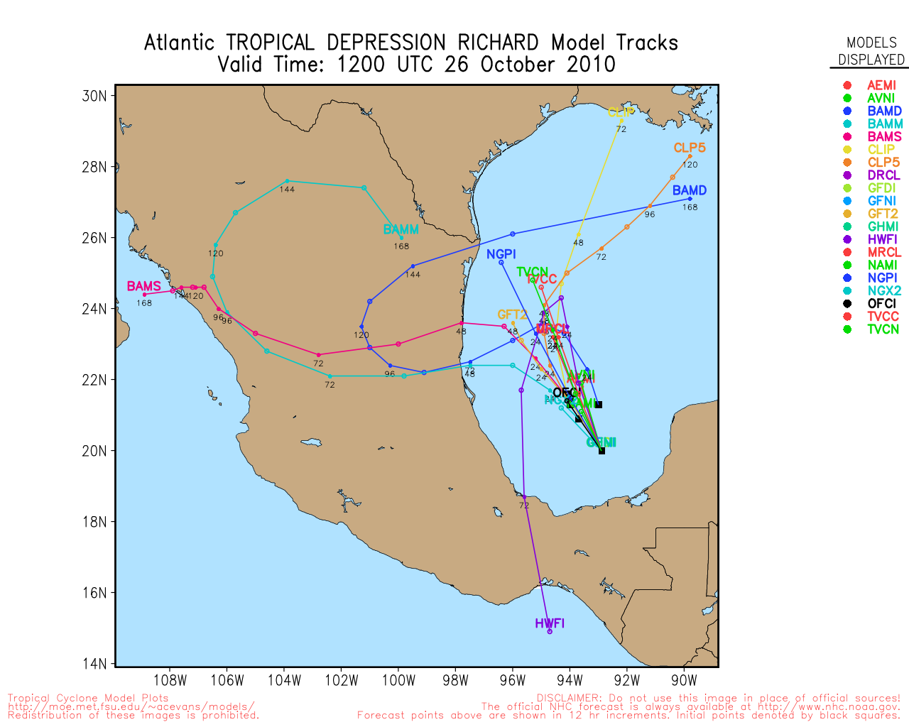
Watching 99L in the west Caribbean, 30% chance of development, may develop this week. Most likely it will move over land before developing.
9:30PM 14 October 2010
Paula is moving due east tonight, staying along the northern coast of Cuba, it will continue to be affected by shear.
Meanwhile another area in the southwest Caribbean will need to be watched for mid-next week. It has a shot to become a large system, but likely to remain in the Caribbean for the time. Those in Nicaragua and Honduras will want to keep a close eye on it.
9:00AM 14 October 2010
Hurricane Paula is moving northeast slowly near the western tip of Cuba, it is expected to remain south of Florida. The Keys and South Florida will see some rain from the system, but not all the much.
Cancun Radar Recording of Paula approach (flhurricane)
12:00PM 13 October 2010
Tropical Storm Watches are now in effect for the Middle and Western Florida Keys. From Craig Key westward including the Dry Tortugas.
Paula is maintaining Category 2 wind speeds and has begun to turn slightly toward the NNE.
7:00AM 13 October 2010 Update
Hurricane Paula is a small, compact hurricane, with hurricane force winds only around 15 miles from the center, because of this and the strong mid level flow over Florida which likely would shear the storm are going to keep the system more of a worry for Western Cuba than the Florida Keys. In fact, any wind there is more likely from the pressure gradient to the north than from Paula itself.
This morning Paula is a good ways east of the Yucatan and Cancun, and they won't see all that much from it because it is such a small storm. It it likely to weaken as it gets further northward today.
On the current forecast track, Paula is likely to stay well south of Florida, enough that Key west may get a little rain from the system, but nothing more as Paula will likely be torn up or kicked back south if it attempted to get to close to Florida. In fact, the entire Gulf of Mexico and Florida is very hostile for tropical systems at the moment.
2:00PM 12 October 2010 Update
Hurricane Paula has been upgraded to a Category 2 hurricane. It is a relatively small hurricane, with strong winds around the center. Recon aircraft was in there recently and found the winds. Forecast on track remains unchanged from earlier.
7:00AM 12 October 2010 Update
Paula was upgraded to hurricane status overnight, but is a bit ragged on satellite presentation. The movement (or lack of) with Paula will likely keep it in the Western Caribbean all week, bringing extended ugly conditions along the eastern Yucatan and Belize.
Odds highly favor it staying out of the Gulf, those in Western Cuba, the Caymans, Belize, and the Yucatan have the most to watch from Paula. The Yucatan is under a hurricane warning. IF Paula gets picked up this week it will likely stay south of the United States, if it were to drift further north it would run smack into very high shear which would likely weaken the system. If it misses the first pickup conditions relax for a bit then pick up again when another front comes along mid next week or so. all this makes it highly unlikely that it will affect Florida.
The cone (well more like big circle) includes parts of south Florida, so it's worth watching, but currently chances are that Florida will not see anything from Paula. And if it did, it likely would be on the weak side.
5:30PM 11 October 2010 Update
Tropical Storm Paula has formed in the western Caribbean.
Hurricane Warnings are up for the Yucatan Mexican coastline from Punta Gruesa northward up to Cancun, including Cozumel.
Paula is expected to strengthen into a hurricane, and in fact is already on it's way with 60MPH winds. (Recon reported.
Those in the warning area will want to prepare.
Tropical storm warnings exist from Limon east in Honduras.
Paula is expected to stay in the general area of the western Caribbean all during the week and will have to be monitored for a while. Those in Western Cuba will want o monitor for changes as well. As of now the likelihood of a direct Florida impact this week or next is very low.
Those in Cancun and Cozumel will want to prepare for possibly prolonged nasty conditions.
Original Update
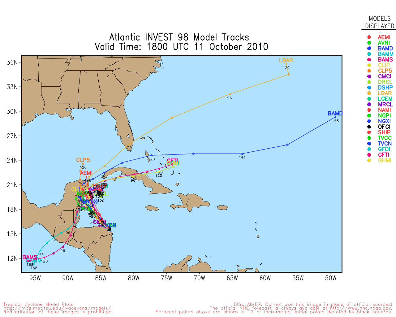
Otto is gone, and we are left with no tropical systems in the Atlantic, but one area in the Western Caribbean (tracked as 98L) that is bringing heavy rainfall to Nicaragua and Honduras now.
The steering currents in the area are almost nonexistent, so this will likely sit in the same general area all week. It is the same story as last week, it will either move into Central America or the Yucatan and rain itself out or meander around, and possibly have new "centers" form and eventually get kicked eastward and out. Tropical Development chances are around 60% today, and tonight or tomorrow still seems most likely for development.
Those in the Yucatan, Belize, Honduras, Nicaragua, Western Cuba, and the Caymans need to watch this system closely. If reformation occurs further north, then the Florida Keys and South Florida will want to watch for a possible "Backdoor" type system, although chances of that are very low right now.
Model tracks are next to useless right now. The most likely scenario is that it stays near Central America and then pushes off east late this week or early next week, and stays south of Florida.
|
MichaelA
Weather Analyst

Reged:
Posts: 944
Loc: Pinellas Park, FL
|
|
Wondering if this will be 2010's last gasp. Getting toward mid-October and cold fronts are beginning to push well into the Gulf of Mexico and down the FL peninsula with the accompanying westerlies and much drier air masses. The potential for subtropical storms remains fair as those fronts wash out over the region, though.
--------------------
Michael
PWS
|
cieldumort
Moderator

Reged:
Posts: 2305
Loc: Austin, Tx
|
|
Invest 98L has more than easily passed the sniff-test IMHO, and has already more than qualified for an official upgrade to TD status. Wind reports in the area do not yet seem to justify a direct upgrade to a named tropical storm, but then, recon is only now en route to the cyclone and available reports are somewhat sparse in the region.
The center of the cyclone looks like it could already be inland over northeastern Honduras, and moving generally west-northwest, so a reemergence over the water is very possible, assuming it is not at this time over water.
In summation, it appears watches and warnings will almost certainly be issued for locations from Honduras to the Yucatan peninsula, and possibly already including western Cuba, in short order, as the cyclone continues to pass either just inland or just offshore central America, with the potential to also drift northwesterly to northerly a bit, should it not continue rolling further west-northwestward into central America to rain itself out, or otherwise become less organized in that region.
Very heavy rain is likely already occurring.
--------------------
Fully vaccinated as of May 2021
(Moderna x2)
|
danielw
Moderator

Reged:
Posts: 3525
Loc: Hattiesburg,MS (31.3N 89.3W)
|
|
RECON is over the NW Caribbean and about 250 miles East of Belize City, Belize.
Currently flying over 18N/ 84 W with flight level winds from the ENE at 5- 10 kts.
|
MichaelA
Weather Analyst
Reged:
Posts: 944
Loc: Pinellas Park, FL
|
|
What is that last image on the sat loops? It says Oct 11 10 1645 UTC, but it simply doesn't fit.
Edit: Still present in the loops, but subsequent images are correct.
--------------------
Michael
PWS
Edited by MichaelA (Mon Oct 11 2010 06:36 PM)
|
Ed Dunham
Former Meteorologist & CFHC Forum Moderator (Ed Passed Away on May 14, 2017)
Reged:
Posts: 2565
Loc: Melbourne, FL
|
|
Initial Vortex message:
URNT12 KNHC 111828
VORTEX DATA MESSAGE AL982010
A. 11/18:11:40Z
B. 15 deg 42 min N
083 deg 45 min W
C. NA
D. 39 kt
E. 314 deg 24 nm
F. 028 deg 46 kt
G. 305 deg 20 nm
H. EXTRAP 1001 mb
I. 22 C / 462 m
J. 23 C / 465 m
K. 6 C / NA
L. NA
M. NA
N. 1234 / 01
O. 0.02 / 1 nm
P. AF300 01HHA INVEST OB 11
MAX FL WIND 48 KT NW QUAD 18:04:20Z
SLP EXTRAP FROM BELOW 1500 FT
FAIR SPIRAL BAND NW AROUND TO NE
OUTBOUND FL WIND 42 KTS NE QUAD 18:15:10Z
|
Ed Dunham
Former Meteorologist & CFHC Forum Moderator (Ed Passed Away on May 14, 2017)
Reged:
Posts: 2565
Loc: Melbourne, FL
|
|
Satellite Floater has been updated to Paula - looks like we'll have TS update at 5PM EDT.
ED
|
Ed Dunham
Former Meteorologist & CFHC Forum Moderator (Ed Passed Away on May 14, 2017)
Reged:
Posts: 2565
Loc: Melbourne, FL
|
|
Second Vortex message - wind speed has increased quite a bit. Pressure now at 1000MB.
URNT12 KNHC 111938
VORTEX DATA MESSAGE AL982010
A. 11/19:24:20Z
B. 15 deg 50 min N
083 deg 51 min W
C. NA
D. 69 kt
E. 297 deg 36 nm
F. 335 deg 50 kt
G. 304 deg 46 nm
H. EXTRAP 1000 mb
I. 23 C / 459 m
J. 23 C / 456 m
K. 7 C / NA
L. NA
M. NA
N. 1234 / 01
O. 0.02 / 1 nm
P. AF300 01HHA INVEST OB 14
MAX OUTBOUND AND MAX FL WIND 77 KT NE QUAD 19:27:50Z
SLP EXTRAP FROM BELOW 1500 FT
MAX FL TEMP 24 C 306 / 13 NM FROM FL CNTR
SPIRAL BAND BETTER ORGANIZED NW AROUND TO NE
INFREQ LTG IN NW QUAD WITH BAND
|
cieldumort
Moderator
Reged:
Posts: 2305
Loc: Austin, Tx
|
|
Highlighting a few key bits of info out of that second vortex message
Estimated (by SFMR or visually) Maximum Surface Wind: 69kts (~ 79.4mph)
Maximum Flight Level Wind: 77kts (~ 88.6mph) in the northeast quadrant at 19:27:50Z
Additional Remarks...
SPIRAL BAND BETTER ORGANIZED NW AROUND TO NE
INFREQ LTG IN NW QUAD WITH BAND
It is worth noting that tropical cyclones that continue intensifying even into landfall, or while scraping a coastline, are often in a phase where should they mostly or fully reemerge back out over open water, rapid intensification may be more likely to commence.
--------------------
Fully vaccinated as of May 2021
(Moderna x2)
|
MichaelA
Weather Analyst
Reged:
Posts: 944
Loc: Pinellas Park, FL
|
|
It's a small storm and the sat presentation is very good. Are we going to go directly to Hurricane Paula, or will play conservative at 5 PM?
--------------------
Michael
PWS
|
CaneTrackerInSoFl
Storm Tracker

Reged:
Posts: 395
Loc: Israel
|
|
Knowing the , they will probably play a little conservative but it should be Paula at 500 since the sat has it as such.
Should most likely have been classified as of last night and I am sure the Post-trop analysis will probably reflect as such.
Could be a dangerous storm if it does not move a lot and keeps the rain coming down on Honduras and Belize.
--------------------
Andrew 1992, Irene 1999, Katrina 2005, Wilma 2005
|
MichaelA
Weather Analyst
Reged:
Posts: 944
Loc: Pinellas Park, FL
|
|
Yeah, not a good situation for an area already saturated from Matthew and Nicole. Of course, if we're looking at a much stronger system than either of those two storms, things could get interesting.
--------------------
Michael
PWS
|
OrlandoDan
Weather Master

Reged:
Posts: 443
Loc: Longwood, FL
|
|
It's official:
satellite imagery...surface observations and data from an Air Force
Reserve hurricane hunter aircraft indicate that the low pressure
area near the coast of Honduras has become a tropical storm...and
an intensifying one at that. In the last couple of hours the
aircraft found a central pressure of 1000 mb and flight-level and
SFMR winds that support an initial intensity of 50 kt...and this
could be a bit conservative. The intensity forecast is above the
SHIPS and lgem guidance given the current intensity trends...and
Paula could reach hurricane status in the next 24 hours. Beyond
that time...Paula may encounter some stronger winds aloft on the
southern edge of the westerlies. The intensity guidance shows
a broad peak from 36 to 72 hours and then slow weakening at days 4
and 5. The official forecast follows this trend and is closest to
the lgem at days 3 through 5.
The initial motion estimate is 315/8 based on aircraft fixes and
earlier estimates of the location of the developing center. Paula
is currently moving around the southwestern side of a subtropical
ridge that extends across the northern Caribbean. Over the next
couple of days...the western edge of the ridge weakens as a broad
deep-layer trough moves east across the southeastern United States.
This should cause the cyclone to turn toward the northwest and
north within 48 hours. After that time...most of the guidance
suggests that the trough will move east and leave the cyclone
behind in an area of weak steering currents over the northwestern
Caribbean. The official forecast shows Paula drifting slowly
eastward at days 3 and 4...with a slow southward motion at day 5.
This forecast is based on a blend of the ...UKMET...and
ECMWF...but confidence is quite low in the details of the track
forecast at this time range.
Based on the forecast...a Hurricane Warning has been issued for
portions of the Yucatan Peninsula.
Forecast positions and Max winds
initial 11/2100z 16.0n 84.0w 50 kt
12hr VT 12/0600z 16.8n 84.8w 55 kt
24hr VT 12/1800z 18.3n 86.2w 65 kt
36hr VT 13/0600z 19.6n 86.6w 70 kt
48hr VT 13/1800z 20.0n 86.4w 70 kt
72hr VT 14/1800z 20.0n 85.5w 70 kt
96hr VT 15/1800z 20.0n 85.0w 65 kt
120hr VT 16/1800z 19.5n 85.0w 65 kt
$$
forecaster Brennan
|
danielw
Moderator
Reged:
Posts: 3525
Loc: Hattiesburg,MS (31.3N 89.3W)
|
|
Recon is nearing the outer bands of Paula at this time.
I'm wondering if the front that is pushing through the Houston, TX area is going to increase it's amplitude enough to pick up Paula and throw a surprise. Just looking at the number of late night severe weather warnings being generated by the front.
|
WeatherNut
Weather Master
Reged:
Posts: 412
Loc: Atlanta, GA
|
|
Looking at the latest MMIC loop from CIMSS, it looks like Paula is about to close off an eyewall
--------------------
Born into Cleo (64)...been stuck on em ever since
|
weathernet
Storm Tracker
Reged:
Posts: 296
Loc: Elsewhere
|
|
Satellite presentation has been pretty impressive all night with -80 tops. Depending on which satellite enhancement one looks at, one could nearly argue the outline of a warm spot and potential developing eye. Other observation is that it would appear that Paula is already moving on a more NNW motion. Any guesses whether we have a vortex message and center fix prior to the 2:00am update? By presentation alone, am going to guess that over the next couple of hours, the plane finds pressures as low as 988mb.
Now that the 0Z is out, am curious as to how Paula was initialized. It would seem to me that it was not quite initialized as a 994mb low, and thus might no be entirely representative of how a deeper system might be impacted by current and near term steering. On another note, it is interesting how the new 0Z model would appear to carry Paula a little farther to the north ( near the lower Keys ) at the point where nearly all steering breaks down.
|
danielw
Moderator
Reged:
Posts: 3525
Loc: Hattiesburg,MS (31.3N 89.3W)
|
|
Observation Time: Tuesday, 5:04Z
Radar Capability: Yes
Aircraft Altitude: Below 10,000 meters
Coordinates: 18.4N 83.7W (View map)
Location: 164 miles (264 km) to the WSW (248°) from George Town, Cayman Islands (GBR).
Turbulence: None
Conditions Along Flight Route: In the clear
Pressure Altitude: 1,520 meters
Flight Level Wind: From 160° at 24 knots (From the SSE at ~ 27.6 mph)
- The above is a spot wind.
- Winds were obtained using doppler radar or inertial systems.
Flight Level Temperature: 18°C
Flight Level Dew Point: 12°C
Weather (within 30 nautical miles): Thunderstorm(s)
850 mb Surface Altitude: 1,519 geopotential meters
Remarks Section - Remarks That Were Decoded...
Surface Wind Speed (likely by SFMR): 13 knots (~ 15.0mph)
Remarks Section - Additional Remarks...
NE Entry Point
|
danielw
Moderator
Reged:
Posts: 3525
Loc: Hattiesburg,MS (31.3N 89.3W)
|
|
URNT12 KNHC 120558 CCA
VORTEX DATA MESSAGE AL182010
A. 12/05:35:30Z
B. 17 deg 13 min N
084 deg 56 min W
C. 850 mb 1362 m
D. 58 kt
E. 038 deg 12 nm
F. 132 deg 58 kt
G. 037 deg 10 nm
H. 991 mb
I. 18 C / 1525 m
J. 21 C / 1521 m
K. 16 C / NA
L. CLOSED
M. C16
N. 12345 / 8
O. 0.02 / 1 nm
P. AF303 0218A PAULA OB 09 CCA
MAX FL WIND 58 KT NE QUAD 05:32:10Z
MAX OUTBOUND FL WIND 48 KT SW QUAD 05:37:10Z
EYEWALL IN EARLY STAGES OF DEVELOPMENT
RADAR PRESENTATION GOOD
|
Bloodstar
Moderator

Reged:
Posts: 462
Loc: Tucson, AZ
|
|
Well, color me surprised, HH have found Peak flight level winds of 93KTs and SFMR of 90KTs along with estimates of 83KTs surface sustained. Oh and a Pressure of 983MB.
Small storms, quick to intensify, quick to fall apart. and I think Paula is well on the way to being a Category 2 storm.
--------------------
M. S. Earth and Atmospheric Sciences, Georgia Tech - May 2020
Brookhaven National Laboratory
U. Arizona PhD Student
Edited by Bloodstar (Tue Oct 12 2010 05:18 PM)
|
cieldumort
Moderator
Reged:
Posts: 2305
Loc: Austin, Tx
|
|
Looks very much as if a bump to Cat 2 would be reasonable. Despite its somewhat pruned satellite appearance, this is still a healthy, intensifying hurricane, internally.
Storm Name: Paula (flight in the North Atlantic basin)
Mission Number: 3
Observation Number: 06
A. Time of Center Fix: 12th day of the month at 17:02:10Z
B. Center Fix Coordinates: 18°41'N 85°49'W (18.6833N 85.8167W) (View map)
B. Center Fix Location: 163 miles (262 km) to the E (85°) from Chetumal, Quintana Roo, México.
C. Minimum Height at Standard Level: 1,291m (4,236ft) at 850mb
D. Estimated (by SFMR or visually) Maximum Surface Wind: 92kts (~ 105.9mph)
E. Location of the Estimated Maximum Surface Wind: 6 nautical miles (7 statute miles) to the ENE (57°) of center fix
F. Maximum Flight Level Wind Inbound: From 137° at 93kts (From the SE at ~ 107.0mph)
G. Location of Maximum Flight Level Wind Inbound: 9 nautical miles (10 statute miles) to the NE (55°) of center fix
H. Minimum Sea Level Pressure: 982mb (29.00 inHg)
I. Maximum Flight Level Temp & Pressure Altitude Outside Eye: 17°C (63°F) at a pressure alt. of 1,524m (5,000ft)
J. Maximum Flight Level Temp & Pressure Altitude Inside Eye: 27°C (81°F) at a pressure alt. of 1,520m (4,987ft)
K. Dewpoint Temp (collected at same location as temp inside eye): 13°C (55°F)
K. Sea Surface Temp (collected at same location as temp inside eye): Not Available
L. Eye Character: Closed Wall
M. Eye Shape & Diameter: Circular with a diameter of 8 nautical miles
N. Fix Determined By: Penetration, Radar, Wind, Pressure and Temperature
N. Fix Level: 850mb
O. Navigation Fix Accuracy: 0.02 nautical miles
O. Meteorological Accuracy: 1 nautical mile
Remarks Section - Remarks That Were Decoded...
Maximum Flight Level Wind: 93kts (~ 107.0mph) in the northeast quadrant at 16:59:10Z
Remarks Section - Additional Remarks...
EYEWALL RAGGED
--------------------
Fully vaccinated as of May 2021
(Moderna x2)
|


 Threaded


