F
Current Radar or Satellite Image

Flhurricane.com - Central Florida Hurricane Center - Tracking Storms since 1995Hurricanes Without the Hype! Since 1995


The 2024 Atlantic Hurricane Season Begins on June 1st and lasts until Nov 30th. NHC Outlooks resume on May 15th..
Days since last H. Landfall - US: Any 237 (Idalia) , Major: 237 (Idalia) Florida - Any: 237 (Idalia) Major: 237 (Idalia)


Archives 2020s >> 2020 News Talkbacks

Pages: 1
MikeCAdministrator
Admin


Reged:
Posts: 4544
Loc: Orlando, FL
Development off South Carolina : Tropical Storm Bertha
      #100956 - Wed May 27 2020 11:43 AM

8:30 AM 27 May 2020 Update
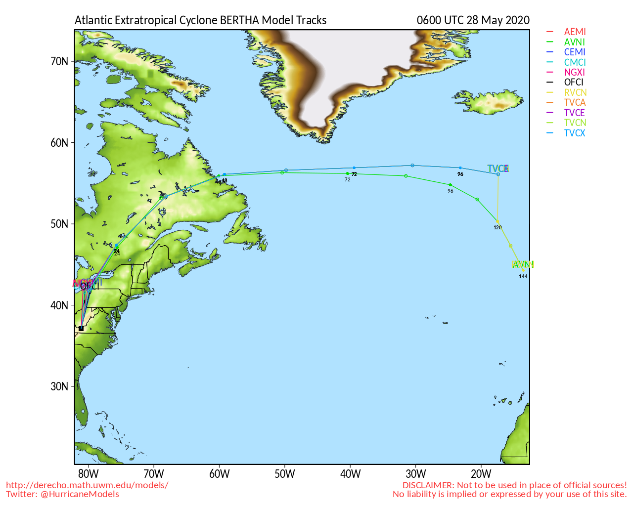
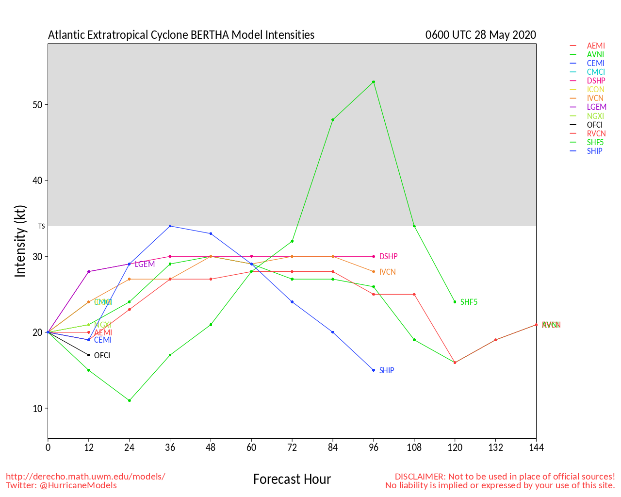
Tropical Storm Bertha Forms offshore of south Carolina.

Tropical Storm Warnings issued for parts of South Carolina. Short lived, and will make landfall later today

A Tropical Storm Warning is in effect for the coast of South Carolina from Edisto Beach to South Santee River.

Original Update

A tropical depression or storm is likely to form just offshore of South Carolina today, before making landfall. Which will have a windy/rainy day. It is not expected to develop more than a minimal tropical storm.


Mid-Atlantic/Carolina Links <html><a href="http://radar.weather.gov/ridge/Conus/southeast_lite_loop.php" onMouseover="ddrivetip('<img src=\'http://radar.weather.gov/ridge/Conus/Loop/southeast_loop.gif\'>');" onMouseout="hideddrivetip();">Southeast Composite Radar Loop</A>

(<a href="http://radar.weather.gov/ridge/Conus/southeast_lite.php" 

onMouseover="ddrivetip('<img src=\'http://radar.weather.gov/ridge/Conus/RadarImg/southeast.gif\>');" onMouseout="hideddrivetip();">Latest Static</a></html>)

<html> <a href="https://radar.weather.gov/ridge/lite/K</html>clx<html>_loop.gif" onMouseover="ddrivetip('<img src=\'https://radar.weather.gov/ridge/lite/K</html>clx<html>_loop.gif\'>');" onMouseout="hideddrivetip();"></html>Charleston, SC Radar<html> Radar Loop</A>

(<a href="https://radar.weather.gov/ridge/lite/K</html>clx<html>_0.gif" onMouseover="ddrivetip('<img src=\'https://radar.weather.gov/ridge/lite/K</html>clx<html>_0.gif\'>');" onMouseout="hideddrivetip();">Latest Static</a>)</html>

<html> <a href="https://radar.weather.gov/ridge/lite/K</html>ltx<html>_loop.gif" onMouseover="ddrivetip('<img src=\'https://radar.weather.gov/ridge/lite/K</html>ltx<html>_loop.gif\'>');" onMouseout="hideddrivetip();"></html>Wilmington, NC Radar<html> Radar Loop</A>

(<a href="https://radar.weather.gov/ridge/lite/K</html>ltx<html>_0.gif" onMouseover="ddrivetip('<img src=\'https://radar.weather.gov/ridge/lite/K</html>ltx<html>_0.gif\'>');" onMouseout="hideddrivetip();">Latest Static</a>)</html>

<html> <a href="https://radar.weather.gov/ridge/lite/K</html>mhx<html>_loop.gif" onMouseover="ddrivetip('<img src=\'https://radar.weather.gov/ridge/lite/K</html>mhx<html>_loop.gif\'>');" onMouseout="hideddrivetip();"></html>Morehead City, NC Radar<html> Radar Loop</A>

(<a href="https://radar.weather.gov/ridge/lite/K</html>mhx<html>_0.gif" onMouseover="ddrivetip('<img src=\'https://radar.weather.gov/ridge/lite/K</html>mhx<html>_0.gif\'>');" onMouseout="hideddrivetip();">Latest Static</a>)</html>

<html> <a href="https://radar.weather.gov/ridge/lite/K</html>akq<html>_loop.gif" onMouseover="ddrivetip('<img src=\'https://radar.weather.gov/ridge/lite/K</html>akq<html>_loop.gif\'>');" onMouseout="hideddrivetip();"></html>Norfolk/Wakefield, VA Radar<html> Radar Loop</A>

(<a href="https://radar.weather.gov/ridge/lite/K</html>akq<html>_0.gif" onMouseover="ddrivetip('<img src=\'https://radar.weather.gov/ridge/lite/K</html>akq<html>_0.gif\'>');" onMouseout="hideddrivetip();">Latest Static</a>)</html> 

Area Forecast Discussions: Charleston, SC - Wilmington, NC - Morehead City, NC - Norfolk/Virginia Beach/Hampton Roads, VA

Power Outage Maps: South Carolina Power Outage Map North Carolina Power Outage Map Virginia Power Outage Map


Post Extras: Print Post   Remind Me!   Notify Moderator  
IsoFlame
Weather Analyst


Reged:
Posts: 295
Loc: One block off the Atlantic Oce...
Re: Development off South Carolina [Re: MikeC]
      #100961 - Wed May 27 2020 12:32 PM

8:30 am: Tropical Storm Bertha (45 mph tracking NW 9 mph) nearing Charleston SC... poised to draw heavy rain bands inland over the Carolinas- areas already saturated by last week's cut-off low..

--------------------
CoCoRaHS Weather Observer (FL-VL-42) & Surf Forecaster: https://www.surf-station.com/north-florida-surf-forecast-3/


Post Extras: Print Post   Remind Me!   Notify Moderator  
EMS
Weather Hobbyist


Reged:
Posts: 55
Loc: St. Petersburg, Florida
Re: Development off South Carolina : Tropical Storm Bertha [Re: MikeC]
      #100962 - Wed May 27 2020 02:10 PM

When was the last time we had a “B” storm before the official start of the season, if ever?

Post Extras: Print Post   Remind Me!   Notify Moderator  
craigm
Storm Tracker


Reged:
Posts: 327
Loc: Palm City, Florida
Re: Development off South Carolina : Tropical Storm Bertha [Re: EMS]
      #100963 - Wed May 27 2020 03:11 PM

Quote:

When was the last time we had a “B” storm before the official start of the season, if ever?


Tropical storm Beryl 5/26/12
On another note - good video here from NOAA's CPC
https://www.youtube.com/watch?v=asD4wtMj73s&feature=youtu.be

--------------------
Why I'm here:
Weather hobbyist


Post Extras: Print Post   Remind Me!   Notify Moderator  
Valandil
Verified CFHC User


Reged:
Posts: 14
Loc: Hamburg, Germany
Re: Development off South Carolina : Tropical Storm Bertha [Re: EMS]
      #100965 - Wed May 27 2020 09:47 PM

Quote:

When was the last time we had a “B” storm before the official start of the season, if ever?


Having two pre-season tropical systems happened a few times in the past, see also https://en.wikipedia.org/wiki/List_of_off-season_Atlantic_hurricanes

Yet, what is unprecedented is that 2020 is the 6th consecutive year with at least one named tropical storm prior to the official start to the season.


Post Extras: Print Post   Remind Me!   Notify Moderator  
Pages: 1


Extra information
0 registered and 0 anonymous users are browsing this forum.

Moderator:  

Print Topic

Forum Permissions
      You cannot start new topics
      You cannot reply to topics
      HTML is disabled
      UBBCode is enabled

Rating:
Topic views: 7626

Rate this topic

Jump to

Note: This is NOT an official page. It is run by weather hobbyists and should not be used as a replacement for official sources. 
CFHC's main servers are currently located at
Hostdime.com in Orlando, FL.
Image Server Network thanks to Mike Potts and Amazon Web Services. If you have static file hosting space that allows dns aliasing contact us to help out! Some Maps Provided by:
Great thanks to all who donated and everyone who uses the site as well. Site designed for 800x600+ resolution
When in doubt, take the word of the National Hurricane Center