MikeC
|
| (Admin) |
| Sat Sep 21 2002 03:12 PM |
|
|
3:30 PM Update
Tropical Depression 13 Will be forming near 10.4N 44.9W (East of the caribbean islands) at 5PM, track expected to strengthen into a storm over the next few days. More later.
Recon reports Isidore's pressure drop to 946 millibars.
3PM Update
Isidore is strengthening, and aircraft recon found evidence of a mesovortex (Tornado-like "mini eyes" within the eyewall of a major storm that tend to cause Andrew scale ground damage). Which suggests we may have a category 4 hurricane in the gulf soon. It has slowed its forward motion. I still think it'll scoot a bit more west, but now I think the chances for a northerly turn are greater now. Still the Entire Gulf, especially LA to Alabama needs to watch. This story is not over by a long shot.
Original Update
Bad puns in topics aside, we now have a Category Three Hurricane moving slowly in the Gulf, near the Yucatan Peninsula, that may be in the Gulf for quite a while.
This is both good and bad, good because upwelling may occur and the environment may change to actually keep Isidore's strength in check or weaken, bad because it's a major hurricane in the Gulf that models are going wild with. So it may not decrease.
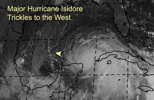
For example, this mornings GFDL model run shows the storm hanging out in the Bay of Campeche. This still makes the strike zone anywhere in the Gulf from Mexico to Florida, and is a little unsettling. Why, some of the other models, which are longer range, have it heading north after a while, and potentially restrengthening again. The length of time this system will wander around will continue to give EM folks around the gulf coast a headache, and everyone else will need to watch it. Mexico to Florida... still. Concentrating on the north central Gulf coasts from tX/LA to FlAL lines. However, if it slides more westward Mexico may get it (Watch the trends). Although I don't think it'll landfall in the Yucatan.
Kyle is a subtropical storm and is also not going anywhere fast. And two more waves in the open Atlantic will have to be watched. As they may near the Caribbean later.
Jim Williams and Barometer bob are doing live Audio shows starting at 8PM and lasting usually to 10 or 11PM all during Isidore's run. Use the link below to check them out.
Havana, Cuba Radar
NRL Monterey Marine Meteorology Division Forecast Track of Active Systems (Good Forecast Track Graphic and Satellite Photos)
NASA GHCC Interactive Satellite images at:
North Atlantic Visible (Daytime Only), Infrared, Water Vapor
Some forecast models:
NGM, AVN, MRF, ETA ECMWF
DoD Weather Models (NOGAPS, AVN, MRF)
AVN, ECMWF, GFDL, MM5, NOGAPS, UKMET
Other commentary at Mike Anderson's East Coast Tropical Weather Center, Robert Lightbown/Crown Weather Tropical Update Accuweather's Joe Bastardi, Hurricane City Weather Audio Broadcast Network - Live Audio from Jim Williams and Barometer Bob , Tropical Weather Watchers.Com (JasonM) Gary Gray's Millennium Weather, Barometer Bob's Hurricane Hollow, Snonut, Ed Dunham and Jason M in our Storm Forum Even more on the links page.
- [mike@flhurricane.com]