MikeC
|
| (Admin) |
| Sun Sep 22 2002 06:03 PM |
|
|
9AM Update
Isidore down to a tropical storm, still meandering over land. I think the threat of a major on the US Coast has gone down, but not far enough to be comfortable. Isidore may never make it back over the open water. I'll wait until the 11AM advisory set to make the next real update.
11PM Update
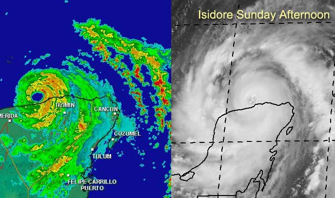
Isidore moved south onto the Yucatan peninsula and is now stalled near Meridia. Dumping tremendous amounts of rain... after plenty of wind and probably storm surge. I believe it has gone as far south as it will. Now it will hang out and eventually move back over the water. I do think it'll restrengthen and head north still.
It has weakened, and may a bit more first.... Still watching and waiting, and still nowhere in the gulf is in the clear yet.
8PM Update
Isidore move totally inland... and is moving southwest. The storm is still strong. A bit of a wildcard was thrown into the forecast. More later...
Original Update
Isidore is jogging a bit south now. But not as west as much, which may make things interesting. It's a borderline Cat 3/4 system, and the hurricane center is keeping it a 3 for now due to being so close to land.
Now it's time to eat a bit of crow and admit it'll probably make landfall briefly (as in very... I doubt the entire eye will make it over) on the Yucatan from the north side. (Rare) Then it's still anyone's guess. Yes Mexico seems more likely now, but it isn't as likely as you may think. It still has one more good shot at getting pulled to the north later. Still isidore will be with us for a bit.
The models are still all over, but my previous guess of landfall between TX/LA and FL/AL borders stands unchanged. All of the gulf still has to remain on alert. I just can't rule anything out at this point. Mexico is a close second to the TX/LA - FL/AL call.
Confidence in any of these models or landfall calls:
code:

forget it) 0 1 2 3 4 5 6 7 8 9 10 (sure thing)

          [--*-------------------]
Ie almost nil.
Keep watch folks, this tracking ride's steepest hill has yet to be climbed.
Too add yet another oddity, the mass of clouds east of Isidore, south of Cuba looks like it may becoming its own entity.
Earlier BillD gave me some animated cancun radar loops from last night you can find them here and also here.
TD#13 is moving almost too quickly for it to develop much soon, and may fall apart a bit, although I think it'll regain itself and become lili sometime tomorrow.
Cancun, Mexico Radar
NRL Monterey Marine Meteorology Division Forecast Track of Active Systems (Good Forecast Track Graphic and Satellite Photos)
NASA GHCC Interactive Satellite images at:
North Atlantic Visible (Daytime Only), Infrared, Water Vapor
Some forecast models:
NGM, AVN, MRF, ETA ECMWF
DoD Weather Models (NOGAPS, AVN, MRF)
AVN, ECMWF, GFDL, MM5, NOGAPS, UKMET
Other commentary at Mike Anderson's East Coast Tropical Weather Center, Robert Lightbown/Crown Weather Tropical Update Accuweather's Joe Bastardi, Hurricane City Weather Audio Broadcast Network - Live Audio from Jim Williams and Barometer Bob , mpittweather , Tropical Weather Watchers.Com (JasonM) Gary Gray's Millennium Weather, Barometer Bob's Hurricane Hollow, Snonut, Ed Dunham and Jason M in our Storm Forum Even more on the links page.
- [mike@flhurricane.com]