CFHC
|
| () |
| Wed Sep 25 2002 12:13 AM |

|
|
|
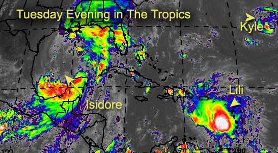
The energy... and core... sapped from Isidore... Will it be a hurricane once more?
Possibly. It has to regain an awful lot of momentum and showers around the core, and the main convection is away from it. The time over the Yucatan really killed the system.
Still TX/LA to AL/FL borders for landfall there, but I'm not expecting more than a cat 1 at the moment, although it could change... watch the system.
Lili is going to fight land a few times, and we may see it go in the Gulf or along the east coast. Apologies today, I've been away most of the time and have yet to go through all the data as of yet.
I hope for more tomorrow. Sorry for the short update today.
Cancun, Mexico Radar
NRL Monterey Marine Meteorology Division Forecast Track of Active Systems (Good Forecast Track Graphic and Satellite Photos)
NASA GHCC Interactive Satellite images at:
North Atlantic Visible (Daytime Only), Infrared, Water Vapor
Some forecast models:
NGM, AVN, MRF, ETA ECMWF
DoD Weather Models (NOGAPS, AVN, MRF)
AVN, ECMWF, GFDL, MM5, NOGAPS, UKMET
Multi-model plots from WREL
Other commentary at Mike Anderson's East Coast Tropical Weather Center, Robert Lightbown/Crown Weather Tropical Update Accuweather's Joe Bastardi, Hurricane City Weather Audio Broadcast Network - Live Audio from Jim Williams and Barometer Bob , mpittweather , Tropical Weather Watchers.Com (JasonM) Gary Gray's Millennium Weather, Barometer Bob's Hurricane Hollow, Snonut, Ed Dunham and Jason M in our Storm Forum Even more on the links page.
- [mac]