CFHC
|
| () |
| Fri Oct 25 2002 01:24 PM |

|
|
|
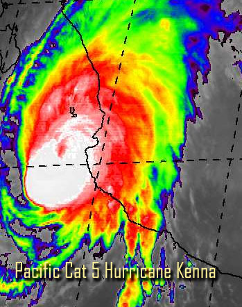
Category 5 eastern Pacific Hurricane Kenna, very impressive earlier, is landfalling on the western mexican coast. It's moving fairly quickly toward it.
We wish the best of luck to those who hopefully prepared on the Mexican West coast.
In the Atlantic, we've got some disturbed weather in the southwest caribbean. I don't expect any more development this month, it's still possible, but I don't expect it.
NRL Monterey Marine Meteorology Division Forecast Track of Active Systems (Good Forecast Track Graphic and Satellite Photos)
NASA GHCC Interactive Satellite images at:
North Atlantic Visible (Daytime Only), Infrared, Water Vapor
Some forecast models:
NGM, AVN, MRF, ETA ECMWF
DoD Weather Models (NOGAPS, AVN, MRF)
AVN, ECMWF, GFDL, MM5, NOGAPS, UKMET
Multi-model plots from WREL
Other commentary at Mike Anderson's East Coast Tropical Weather Center, Robert Lightbown/Crown Weather Tropical Update Accuweather's Joe Bastardi, Hurricane City Weather Audio Broadcast Network - Live Audio from Jim Williams and Barometer Bob , mpittweather , Tropical Weather Watchers.Com (JasonM) Gary Gray's Millennium Weather, Barometer Bob's Hurricane Hollow, Snonut, Ed Dunham and Jason M in our Storm Forum Even more on the links page.
- [mike@flhurricane.com]