MikeC
|
| (Admin) |
| Sat Jul 31 2004 11:54 PM |
|
|
2:30 PM Aug 1 Update: TD 1 Becomes Tropical Storm Alex
We now have our first named system of this season. At 2PM, NHC upgraded TD1 to TS Alex - located about 80 miles SSE of Charleston, South Carolina. Alex is a minimal TS with sustained winds of 35 knots, and it is currently stationary. The NHC still expects Alex to eventually move to the north and northeast so Tropical Storm Warnings remain in effect for the coastal areas of the Carolinas.
Personally, I would have placed the center a lot further to the south based on the main feeder band, but since the storm has about a half dozen areas of low-level circulation, I guess that for the moment, any one of them will do. Coastal residents of Georgia should also keep a close eye on Alex.
ED
10:45 AM Aug 1 Update:
Tropical Storm Warnings are now up from Cape Fear to Cape Hatteral in North Carolina.
10:30 AM Aug 1 Update:
Tropical Depression 1 is looking better this morning, with Dvorak T#s at 2.0. There is a good chance it'll become Tropical Storm Alex today, but due to its proximity to land the likelyhood of it strengthening much more is slip.
However, I do suspect it will be in strengthening mode when it does make landfall. It's center seems to be reforming now, or adjustin itself.
More to come later.
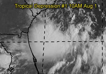
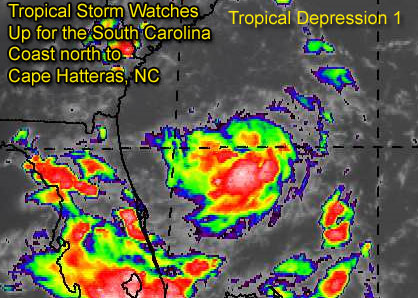
Original Update
Tropical Depression One has formed east of the Florida Peninsula, and is still rather disorganized. It's track takes it northward towards the Carolinas, and because of this, Tropical Storm Watches are out for South Carolina all the way up to Cape Hatteras in North Carolina.
Folks in the area should be aware of it.
The system in the Gulf (90L) is looking very ragged now, and may not form into a depression. But another storm west of the Cape Verde Islands in the far eastern Atlantic may form over the next few days and become our first "cape verde" tracker of the season. We'll keep an eye out on everything.
More updates to come on TD#1...
Event Related Links
Charleston, SC Long Range Radar
Jacksonville, FL Long Range Radar
General Links
Current Aircraft Recon Info
NRL Monterey Marine Meteorology Division Forecast Track of Active Systems (Good Forecast Track Graphic and Satellite Photos)
Check the Storm Forum from time to time for comments on any new developing system.
Follow worldwide SST evolution here:
Global SST Animation
NASA GHCC Interactive Satellite images at:
North Atlantic Visible (Daytime Only), Infrared, Water Vapor
Some forecast models:
NGM, AVN, MRF, ETA ECMWF
AVN, CMC, GFDL, JMA, NOGAPS, UKMET
DoD Weather Models (NOGAPS, AVN, MRF)
Multi-model plots from WREL
Other commentary at Mike Anderson's East Coast Tropical Weather Center, Independentwx.com, Robert Lightbown/Crown Weather Tropical Update Accuweather's Joe Bastardi (now subcriber only unfortunately), Hurricane Alley North Atlantic Page, Cyclomax (Rich B.), Hurricane City , mpittweather , Gary Gray's Millennium Weather, Barometer Bob's Hurricane Hollow, Snonut,
Even more on the links page.