MikeC
|
| (Admin) |
| Tue Sep 14 2004 11:08 AM |
|
|
2PM EDT Update
Hurricane Ivan is holding as a Category 4 storm, and the eye is roughly 40 miles wide now. Intensity is expected to fluctuate and go down a little bit more, the track remains the same.
Jeanne has strengthened a bit this morning, recon has found winds around 50MPH as it approaches Puerto Rico and the Virgin Islands. It has the chance to strengthen a bit more as time goes on. Good luck to those in Puerto Rico like CyclonEye (s2k) and others.
Original Update
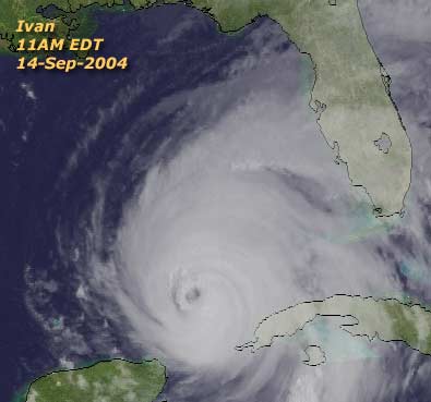
Hurricane Ivan has gone through weakening this morning, with pressures rising and windspeed falling. Ivan's windspeed at 11AM (EDT) was 140MPH, but according to the National Hurricane Center it actually may be slightly less as they were still waiting on a few more recon reports at the time of the advisory.
Errors may be large in this track, folks in the Hurricane Watch area must prepare.


The track remains very similar to the last one this morning so there are no changes there--maybe a little more west. It projects Landfall near the Alabama, Nississippi border, and it looks fairly solid. (Athough all the areas in the Hurricane watch need to prepare, storms are fickle)
(Track Map Thanks to Skeetobite)
Ivan is forecast to weaken some more, but before it arrives it land it will go over a warm eddy in the Gulf and have a chance to restrengthen a bit. Ivan will likely still be a major Hurricane when it makes landfall.
Jeanne is a minimal Tropical Storm over the leeward islands in the Caribbean, Tropical storm warnings are up for other islands in the area. a windy, rainy event for them. After that, models trend it northwest but East of the Bahamas. Not sure on it yet. Time to watch later.
More to come later.
Hurricane Local Statements for Weather Offices in:
All Current Hurricane Local Statements
Tallahassee, FL (Panhandle) - Long Range Radar Loop
Mobile, AL - Long Range Radar Loop
New Orelans, LA - Long Range Radar Loop
San Juan, PR - Long Range Radar Loop
Key West, FL - Long Range Radar Loop
** SITE NOTE ** Although we are working on improving the site hardware and bandwidth (thanks to donations and help from others), we are still using the old system currently, with slight modifications. Therefore the site may go down from time to time, although not for very long. We are continually working on improving the response without removing usefulness. We have new hardware on order and should be in sometime next week.
Those asking for a mailing address for donations should use
Mike Cornelius
804 Omni Blvd
Suite 101
Newport News, VA 23606
Event RelatedLinks
Closeup Animated Visible Satellite of Ivan
Anmated Ivan Visible floater Satellite
Buoy Reports from a buoy near Ivan
Police , fire and rescue scanner audio feeds from Gulf Coast locations
Ivan Models -- This image animated over time
Jeanne Models -- This image animated over time
Ivan Spaghetti Model from Hurricanealley/boatus (Working Link)
Weather Underground Model Plots for Ivan
The Caribbean Hurricane Page - updates from the islands
Caribbean Island Weather Reports
Nice color satellite image
Animated Color Ivan Satellite (With NHC Track Overlay)
(Animated Version)
High Speed Satellite Loops (Click floater)
Forecast Discussions for (Show All Locations):
Tampa. Miami, Key West, Tallahassee.
Melbourne
Gulf of Mexico Water temperatures
General Links
Skeetobite's storm track maps
Current Aircraft Recon Info (Decoded) thanks Londovir
Other Recon Info
Disaster Relief Information
NRL Monterey Marine Meteorology Division Forecast Track of Active Systems (Good Forecast Track Graphic and Satellite Photos)
Check the Storm Forum from time to time for comments on any new developing system.
Follow worldwide SST evolution here:
Global SST Animation
NASA GHCC Interactive Satellite images at:
North Atlantic Visible (Daytime Only), Infrared, Water Vapor
LSU Sat images
Some forecast models:
NGM, AVN, MRF, ETA ECMWF
AVN, CMC, GFDL, JMA, NOGAPS, UKMET
DoD Weather Models (NOGAPS, AVN, MRF)
Multi-model plots from Mid-Atlantic Weather
Other commentary at Independentwx.com, Robert Lightbown/Crown Weather Tropical Update Accuweather's Joe Bastardi (now subcriber only unfortunately), Hurricane Alley North Atlantic Page, HurricaneVille, Cyclomax (Rich B.), Hurricane City , mpittweather , WXRisk, Gary Gray's Millennium Weather, storm2k, Barometer Bob's Hurricane Hollow, Snonut,
Even more on the links page.