CFHC
|
| () |
| Tue Sep 17 2002 05:51 PM |

|
|
|
Tropical Depression #11 forms east of Bermuda and is heading to the North at 8mph. Most likely this system will not strengthen too much and become an extratropical fish spinner.
Tropical Depression #10 is a different story. Ten is keeping everyone on edge with its unknown path and strengthening potential. Ten is moving toward the west-northwest near 6mph and a motion to the west-northwest or northwest is expected during the next 24 hours. Also ten is expected to become a tropical storm within the next 24 hours
NRL Monterey Marine Meteorology Division Forecast Track of Active Systems (Good Forecast Track Graphic and Satellite Photos)
NASA GHCC Interactive Satellite images at:
North Atlantic Visible (Daytime Only), Infrared, Water Vapor
Some forecast models:
NGM, AVN, MRF, ETA ECMWF
DoD Weather Models (NOGAPS, AVN, MRF)
AVN, ECMWF, GFDL, MM5, NOGAPS, UKMET
Other commentary at Mike Anderson's East Coast Tropical Weather Center, Accuweather's Joe Bastardi, Hurricane City, Gary Gray's Millennium Weather, Barometer Bob's Hurricane Hollow, Snonut, Ed Dunham and Jason M in our Storm Forum Even more on the links page.
- [john@flhurricane.com]
| Unregistered User |
| (Unregistered) |
| Tue Sep 17 2002 05:56 PM |
|
|
there is a power house front coming should be no no were to go but n/e south fl if that gulf coast have a nice weekend
| HanKFranK |
| (User) |
| Tue Sep 17 2002 06:27 PM |

|
|
|
hey anon. you havent got a clue. would take a pretty big amplification along the east coast to get this baby to recurve that sharply, and none of the globals have that. most have the storm trying to phase into the shortwave leading the next amplification, as does the official forecast. as a matter of fact, nogaps is playing outlier, it keeps the storm welll south of the amplification, right off NW cuba, builds the ridge back overhead, and turns it WSW into the bay of campeche. i find that more likely than your guess, which is better suited for late season systems.
anyway that nogaps run is the best support i can find for a further west system. if the trough forecast to draw what will be isidore up doesnt get the storm, then the mexico nogaps drive could be on to something.
but, most likely path right now is up into west central or northwestern florida, somewhere.
HF 2221z17september
| Colleen A. |
| (Moderator) |
| Tue Sep 17 2002 06:39 PM |

|
|
|
Ok, I'm confused, HF. Are you saying that you think FL is a target or you think it will get pulled more west? I'm not being a smart alek, just tired today. Thanks...
| HanKFranK |
| (User) |
| Tue Sep 17 2002 07:02 PM |
|
|
|
|
i'm saying it's more likely it will miss the trough entirely and turn west than for the trough to be deep enough to turn it sharply east and only affect south florida.
18z avns have a less dramatic version of nogaps 12z, the system gets to NW cuba and just stalls there for a while, then starts moving wnw. considering avn has the system as a 1008mb low.. and nogaps is only somewhat deeper.. i wouldnt take them that seriously. when the storm is up there friday it will probably be lower than 970mb. the upper trough is more likely to recurve a strong system than a weak one.
HF 2256z17september
| ShawnS |
| (Storm Tracker) |
| Tue Sep 17 2002 07:04 PM |
|
|
I still say west gulf or bust!
| Unregistered User |
| (Unregistered) |
| Tue Sep 17 2002 07:16 PM |
|
|
Wherever he goes, hes gonna be a monster. Did you get a load of the 22:40 IR?? holy cow batman!! Starting to wrap where the recon put it's last fix. Being that the NHC shifted it's track to the right, and the intensity which is starting to occur, I buy the NHC track for the time being. When cyclones develop strongly they want to go poleward unless there is a strong ridge to prevent that, like Mitch and Keith, that got caught under the heat ridge. I don't want to get hit by this one!! GOM you can take him, but you'll have to rebuild. Cheers!! Steve H.
| Rad |
| (Weather Guru) |
| Tue Sep 17 2002 07:40 PM |

|
|
|
TOOO soon to call this one , MUST wait till Thursday , to have a better handle on this tropical entity.
| clyde w. |
| (Storm Tracker) |
| Tue Sep 17 2002 07:47 PM |
|
|
Latest recon put the center at 16.6N and 77.6W, right under the deep convection. The storm is getting better organized, but flight level winds were still only 38kts and pressure still 1006mb.
| 57497479 |
| (Weather Master) |
| Tue Sep 17 2002 07:52 PM |

|
|
|
I'm starting to become very concerned , we have talked for years now about a hurricane hitting central fl and now that it may really come to pass I have to admit that it has me a little distressed. Any hurricane is dangerous but the thought that a majior storm my be headed this way has me sitting on the edge of my seat.
Once it gets into the gulf the ball game starts just don't know what base it will stop on. All kidding aside all of the gulf coast should be on alert for this one, now is the time to do your planning and make sure you have plenty of supplies that you may need for several days.There's a lot that can happen between now and then but you can never be prepared enough , just ask the Andrew survivors.
I just want to say again that you all do a great job keeping us updated on the latest. Toni
| ROB H |
| (Weather Watcher) |
| Tue Sep 17 2002 07:58 PM |

|
|
|
I think the NHC has a good handle on this storm and trust
their forecast thru 72hrs. after that things could get iffy.
If the trough pickes it up its a no brainer, landfall between
sarasota and cedar key, if it misses the trough than it
goes to the big " catchers mitt" known as the big bend
| clyde w. |
| (Storm Tracker) |
| Tue Sep 17 2002 08:00 PM |
|
|
Either way it would be bad news for the gulfcoast of FL.
| Unregistered User |
| (Unregistered) |
| Tue Sep 17 2002 08:17 PM |
|
|
I'm letting you guys have fun with this one. All the local mets are forecasting cooler and milder weather in the Mon-Wed period for New Orleans. Highs in the mid 80's, lows in the upper 60's. A little taste of early fall. I think we're out the tropical woods at least until the end of next week.
Good luck. Buy your water and stock that freezer with a few extra bags of ice now. I have absolutely no call on this system as it's still at least 96 hours away from any known targets. As of now, I'm thinking NC FL then up through the SE and out to sea. Early no-idea prediction would be in the St. George/Appalachacola area with the bulk of the problems between there and Lake City.
Steve
| Unregistered User |
| (Unregistered) |
| Tue Sep 17 2002 08:27 PM |
|
|
A nice ridge has developed, the shear has retreated from the north and from the west...and everything is in place. the LLC is under a mass of heavy convection, the movement is at a good speed....the water temp is perfect....so let's ask ourselves...any reason NOT to expect a major cane out of this?.....i don';t think so...and i am now quite convinced it will hit hard.
Interestingly...when they are super strong..like Gilbert or Hugo...they tend to bee-line...kinda go in a more straight path than anything else....so if this thing blows up into a heavy...look for a fairly predictable straight path or natural curve..
Mobile...cat 5, 210 MPH winds....well, maybe not...but it will definitely be keeping all of us on our seats...
Insurance paid up?
| Unregistered User |
| (Unregistered) |
| Tue Sep 17 2002 08:42 PM |
|
|
Similar to the dvorak technique to predict storm stregth, I have developed something I'd like to call the "anon" technique for predicting where most users will predict the path of a storm. To precisely predict each users prediction, simply place an X at the current LLC, place another over the users home..now get out your ruler and draw a straight line between the two. This will be their prediction
All fun aside, last couple images from this thing look more organized than its been to date. Should be interesting to see which user looses his/her home.
| Unregistered User |
| (Unregistered) |
| Tue Sep 17 2002 09:03 PM |
|
|
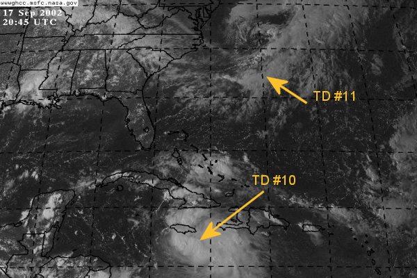
One Comment: TD #11 is labeled incorrectly in the above picture; it's actually further east. One question: If you look at the Hi res IR loops at the NASA site you can still see high cloud elements streaming towards the center of TD #10 from the South West while at the same time you can see the outflow of TD #10 going the other way. Which is higher?
| Ronn |
| (User) |
| Tue Sep 17 2002 09:12 PM |

|
|
|
With a potential landfall looming here on Florida's west coast, I was lured out of hiding to post here at CFHC. It appears that this upcoming weekend will be very interesting for Florida.
This evening's satellite imagery indicates increasing convection in TD 10's western quadrant with heavy activity directly over the surface circulation. While the system is still organizing itself, it is poised for rapid intensification. The upper low over the NW Caribbean continues to distance itself from TD 10 and an upper anticyclone is building overtop the system. Westerlies from an intensifying trough north of Puerto Rico are facilitating excellent ventilation for the depression. Considering these increasingly favorable conditions aloft and warm Caribbean SSTs, strengthening to hurricane status may be in short order after initial organization during the next 12 hours.
The current trough over the southern Plains will have little impact on TD 10. The second trough that will dig into the western Plains on Wednesday will eventually halt westward progress of our storm and turn it north and northeast. I see no reason to differ from TPC's forecast track. The storm will continue to track WNW for another 36-48 hours and will be moving NW as it nears western Cuba in 72 hours. Thereafter, it is just a matter of how sharp of a turn occurs. I am quite confident that this will be an east Gulf storm. I don't foresee any landfall west of 85 W. If anything, the forecast track may be shifted eastward with time. It looks like some part of Florida's west coast will be under the gun in 96 hours. My best bet right now is the SW coast. It will be interesting to see how much SW shear and intruding dry air the trough causes when our storm is in the SE Gulf.
That wlll be it for now.
God Bless,
Ronn
| HanKFranK |
| (User) |
| Tue Sep 17 2002 09:13 PM |
|
|
|
|
i keep hearing 'convection is starting to wrap around the center' and 'i can see the spin' all the time.. yet still we still have a big amorphous system with convection bursting mostly east of the center. the center is still at the eastern edge of the whole mass, below the western side of jamaica. folks really just plot the center from the vortex message (it has been erratically bobbing around south of jamaica all day) and you can see that the storm is still lopsided and disorganized. believe it or not the reason the storm isnt intensifying is BECAUSE of all the convection away west. put it in the wrong place and it starves the center of inflow, if the upward forcing is going on elsewhere. the richest inflow in this case is the low level easterly flow... and where is most of the deep (very deep) convection.. east of the center.
system is still the snowball at the top of the hill. once the convection finally starts to 'wrap' as everybody always claims to see (or at least some bursts west of the center, or directly overhead).. then this thing will start to deepen like crazy.
keep delaying that and the storm misses critical guidance connections.. in other words we get a wandering system that doesnt try to phase in. a massive storm that is a forecasting nightmare.
its very unlikely this storm will continue to avoid deepening indefinitely, but not impossible. i must say though, i have never seen a storm in a better position keep refusing to knock out the one stone that causes the mountain to fall.
HF 0105z18september
| Unregistered User |
| (Unregistered) |
| Tue Sep 17 2002 09:26 PM |
|
|
the storms have a cycle to them, don't they?...I mean..they can only go through a natural cycle of birth....generation...and the maturation phase. I watched a special about them, and the last thing we need is a storm to hit just as it's getting it's act together...like Gilbert. or Camille, ....or Andrew. the longer this delays the development...the greater the likelihood the present path will continue...making it more east than many think....
at any rate...when one thinks about it...the bad area is only gonna be 150 miles wide..max....so if it misses you by just 75 miles...it will be a yawner....they have to pretty much smack ya dead on....
not that i'm wishing for it or anything....just a note...odds are remote it will hit any of us...but odds are real good one of us is gonna experience LIGHTS OUT....!!!!!
keep up the posts...I am learning more and more each season...this is definitely the best site going...wouldn't mind more input from some of you weather novices (like myself)....
still think it will split the gap and enter the gulf a cat 3 or better...and then intensify ....
get the beer on ice....less than a week and it's lights out babeeeeeee...probably Tuesdayish?....
| mbfly |
| (Weather Guru) |
| Tue Sep 17 2002 09:34 PM |
|
|
|
|
Hey Rick ! We got ours here in Mobile last weekend....such that it was. NO way we're gonna get hit twice in a row, much less in the same year ! We're safe this go around. (I hope !)
| Unregistered User |
| (Unregistered) |
| Tue Sep 17 2002 09:43 PM |
|
|
except that a few years ago I dreamt Mobile got hit twice in the same year....
| Unregistered User |
| (Unregistered) |
| Tue Sep 17 2002 09:53 PM |
|
|
Nice to see you share a post. It's been a while since i've heard from you. Hope things are well will you and yours. Storm has the most potential to wreak havoc since....well..Andrew I guess. Say a prayer for us in Florida (are you still here)? we're gonna need it. CHeers!! Steve H.
| JustMe |
| (Weather Guru) |
| Tue Sep 17 2002 09:54 PM |

|
|
|
OK I have read and watched and read and really gotten interested but Kevin have I missed yout latest thoughts?
I really would like to know what the thoughts are re td10 hitting Florida as a Hurricane.
THanks
JustMe
| Unregistered User |
| (Unregistered) |
| Tue Sep 17 2002 09:55 PM |
|
|
It sure looks like the center would be right in the middle of the c shaped black blob in this IR picture doesnt it, remember that recon had repositioned the center further ne than where it was, maybe it has shifted back ne some more? http://www.ssd.noaa.gov/PS/TROP/DATA/RT/FLOAT/IR4/20.jpg
| Unregistered User |
| (Unregistered) |
| Tue Sep 17 2002 09:58 PM |
|
|
never say never year 95 2 storms back to back one was opal these thing play tricks north gulf be ready for that trick if we new were this thing was realy going we would be somewhere else but we will gess for the next 5 days because we love it and one of us will be right pray that its not you
| Joe |
| (Storm Tracker) |
| Tue Sep 17 2002 09:58 PM |
|
|
TD#10 much better organized and best yet. Center looks to be centered right in middle of deep convection. Next update should have this at TS. Looks as though its going to get stronger from here on out.
| Unregistered User |
| (Unregistered) |
| Tue Sep 17 2002 10:02 PM |
|
|
Joe Bastardi says the energy to the west of it....over central america and in the pacific a tad...is inhibiting the energy flow...sort of "competing with" the system for available energy. .well, he said that this morning. the latest loops show that this one is starting to "take over"....any one else see that? I see our little td #10 sucking the energy from the west...and one thing Bastardi said...if any of the energy "masses" take over...watch out!
| WXMAN RICHIE |
| (Weather Master) |
| Tue Sep 17 2002 10:10 PM |

|
|
|
Possible Flooding Over South Florida Late This Week...
Tropical depression number 10 in the western Caribbean Sea south of Jamaica early Tuesday evening is forecast by the National Hurricane Center to move west northwest the next 12 to 24 hours. Rain associated with this system may begin to impact South Florida on Thursday and possibly continue for several days. The rainfall could be excessive and cause widespread flooding over most of South Florida.
| Colleen A. |
| (Moderator) |
| Tue Sep 17 2002 10:10 PM |
|
|
|
|
I just looked at the floater pix posted above....and it looks eerily similar to THIS:
Dvorak Intensity Classification
Check out the 3.5 Dvorak Image. Is it me or what?
| Unregistered User |
| (Unregistered) |
| Tue Sep 17 2002 10:17 PM |
|
|
looks good to me this thing is growing up fast it needs a name
| Unregistered User |
| (Unregistered) |
| Tue Sep 17 2002 10:21 PM |
|
|
Colleen great site, looks like between 2.5 and 3.5 from what i saw , like i said a c shaped blob
| HanKFranK |
| (User) |
| Tue Sep 17 2002 10:22 PM |
|
|
|
|
aite... the convection is going right over the last center fix. unfortunately no telling if the center is there anymore, it's been jig-bobbing in an overall nnw direction since this morning, up towards western jamaica. but, the convection to the east is receding in the last few images.. maybe it will start concentrating more on developing a convective core now? we'll find out when recon gets back.
HF 0216z18september
| Unregistered User |
| (Unregistered) |
| Tue Sep 17 2002 10:26 PM |
|
|
when is next recon
| Unregistered User |
| (Unregistered) |
| Tue Sep 17 2002 10:31 PM |
|
|
So does anyone think this could be like the 1995 year with Erin/Hanna then Opal/Isidore? hmm. makes sense but who knows? guess will have to wait
| Unregistered User |
| (Unregistered) |
| Tue Sep 17 2002 10:36 PM |
|
|
in three days...from the Navy weather site...what is 70 knots?...about a cat 2?
72 HRS, VALID AT:
201800Z1 --- 23.5N0 84.5W7
MAX SUSTAINED WINDS - 070 KT, GUSTS 085 KT
| Unregistered User |
| (Unregistered) |
| Tue Sep 17 2002 10:39 PM |
|
|
78 mph
Category 1.
Multiply knots by 1.12 to get mph
| Unregistered User |
| (Unregistered) |
| Tue Sep 17 2002 10:49 PM |
|
|
No strengthening.
Movement a little more north than west.
Little slower in 72 hour projections.
same path.
| StormHound |
| (Weather Guru) |
| Tue Sep 17 2002 10:55 PM |
|
|
Wow. This is it, ladies and gentlemen. The one for which we have been waiting all season. We may not see another like this, so get all of your wishcasting out now. Since I am in Orlando, I expect Isidore to come up to Tampa Bay, then jump about 100 miles to Orlando, without loosing any strength. I'm not sure how the storm surge is going to make it this far inland, but I'm sure it will.
| Unregistered User |
| (Unregistered) |
| Tue Sep 17 2002 11:03 PM |
|
|
Tropical Depression Ten Advisory Number 8
Statement as of 11:00 PM EDT on September 17, 2002
...Depression nearing tropical storm strength...
at 11 PM...0300 UTC...the government of Jamaica has issued a
Tropical Storm Warning for Jamaica. A Tropical Storm Warning means
that tropical storm conditions are expected within the warning area
within the next 24 hours.
At 11 PM...0300 UTC...the government of the Cayman Islands has
issued a tropical storm watch for the Cayman Islands.
A Hurricane Watch may be required for portions of western Cuba on
Wednesday.
At 11 PM EDT...0300z...the center of Tropical Depression
Ten was located near latitude 16.9 north...longitude 77.9 west or
about 100 miles...165 km...southwest of Kingston Jamaica.
The depression is moving toward the northwest near 7 mph
...11 km/hr...and this motion is expected to continue during the
next 24 hours.
Maximum sustained winds are near 35 mph... 55 km/hr...with higher
gusts. The depression will likely become a tropical storm on
Wednesday. Most of the strongest winds with the depression
are located well to the north and east of the center. If
strengthening occurs...tropical storm force winds could spread over
portions of Jamaica within the next 12 to 24 hours.
Estimated minimum central pressure is 1006 mb...29.71 inches.
Heavy rains are expected to spread over Jamaica over the next 24
hours...and these rains could cause life-threatening flash floods
and mud slides.
Repeating the 11 PM EDT position...16.9 N... 77.9 W. Movement
toward...northwest near 7 mph. Maximum sustained
winds... 35 mph. Minimum central pressure...1006 mb.
For storm information specific to your area...please monitor
products issued by your local weather office.
An intermediate advisory will be issued by the National Hurricane
Center at 2 am EDT followed by the next complete advisory at 5 am
EDT...Wednesday.
Forecaster Avila
| clyde w. |
| (Storm Tracker) |
| Tue Sep 17 2002 11:04 PM |
|
|
How about the GFDL taking it to 939mb just west of the Keys in 4 days. What would that equate to generally in wind speed--strong cat. 3?
A couple of years ago there used to be a lady who posted here, I think her name was Mary, who, every time a storm looked like it might come near Central Florida would shoo something called the "Lakeland Monster" on it. And every time she did it the storm would turn away, or weaken or something...I don't know what the heck she was talking about but we might need her early next week! LOL!
| Unregistered User |
| (Unregistered) |
| Tue Sep 17 2002 11:05 PM |
|
|
Tropical Depression Ten Discussion Number 8
Statement as of 11:00 PM EDT on September 17, 2002
Satellite imagery indicate that the cloud pattern is definitely
becoming better organized. Convection has increased near the center
with developing banding features and the outflow is rapidly
expanding. It appears to be a tropical storm on satellite.
However...an Air Force plane just finished investigating the
depression and found that the minimum pressure has not changed and
it remains about 1006 mb. Max flight level winds are 41 knots
confined to a small area to the northeast of the center.
Therefore...the system is kept at 30 knots. A new plane will be
there at 6 UTC.
IR images still show some patches of cirrus undercutting the outflow
blowing from the southwest. This was confirmed by data from the
dropsondes launched by the NOAA high altitude jet. These winds have
been producing shear. However...most of the numerical models have
been very persistent in developing a 200 mb ridge over the western
Caribbean for the past few days. In fact...latest NCEP global run
has a 200 mb anticyclone over the system in 48 hours...perfect for
strengthening. With such a good upper-level environment and the
fact that the tropical cyclone is heading toward an area of
very high upper-oceanic heat content...strengthening is indicated.
The system is expected to be a hurricane by the time it approaches
western Cuba. The GFDL continues to be aggressive...bringing the
presure to 939 mb just north of western Cuba.
The depression has been moving toward the northwest or 315 degrees
at 5 or 6 knots during the past few hours. Steering currents are
weak but there is enough ridging to keep the cyclone on a general
slow northwest track through 72 hours. Thereafter...steering
currents are forecast to collapse and the cyclone will move very
little over the southeastern Gulf of Mexico or western Cuba. The
official forecast track is in the middle of the ensemble but is
biased toward the latest NCEP Global Model run. The latter makes
the cyclone nearly stationary over western Cuba or the southeastern
Gulf of Mexico in 4 or 5 days.
Forecaster Avila
forecast positions and Max winds
initial 18/0300z 16.9n 77.9w 30 kts
12hr VT 18/1200z 17.5n 78.7w 35 kts
24hr VT 19/0000z 18.9n 80.0w 45 kts
36hr VT 19/1200z 20.0n 81.0w 55 kts
48hr VT 20/0000z 21.5n 82.5w 65 kts
72hr VT 21/0000z 23.0n 84.0w 75 kts
| Unregistered User |
| (Unregistered) |
| Tue Sep 17 2002 11:07 PM |
|
|
I know how the storm surge will make it to Orlando from Tampa Bay, IT will stop by adventure Island and suck all the water from the water park up and then dump it on Orlando in the middle of I-4 on Friday afternoon at 5 pm, right after the construction work signs go up and a 5 car fender bender happens and all the people involved are each waiting for their personal attornies and insurance adjusters to arrive on the scene.
| Unregistered User |
| (Unregistered) |
| Tue Sep 17 2002 11:33 PM |
|
|
Ok, Here I am again. If you want me to I will sic the Lakeland Monster on this storm, keeping it at a mild Cat 1 hurricane that will be just enough of a scare to get a Hurricane Day off for those of us who are fortunate enough to have jobs that let you go home if a hurricane warning has been issued. Of course that would have to be on a Weekday. Not a Saturday or Sunday....
| clyde w. |
| (Storm Tracker) |
| Tue Sep 17 2002 11:33 PM |
|
|
Here in Orlando our local TV mets had differing views on soon to be Isidore. One is already predicting 'hurricane conditions' for the weekend, while another said 'that maybe this whole thing will blow apart and not affect us'. Yeah, gotta love that technically precise forecasting you get here in O-Town. Hey Jason Kelly, any chance you might move down here???
| HanKFranK |
| (User) |
| Tue Sep 17 2002 11:36 PM |
|
|
|
|
next recon is in at 06z. thats 2am eastern. so if you want to stay up all night, ya can get the next vortex message.
nhc is mentioning the storm stopping near western cuba. apparently more of the reliable models have shifted that way. that makes the florida hit more questionable, and brings the nogaps run that turned the storm wsw and sent it to tampico, mexico by the 23rd. since the storm has dawdled so much in the caribbean, that possiblity is opening. have to see if the models start trending to that, or if they just hang it off the coast and wait for another shortwave to flick it into the states. timetable being pushed back, storm probably not landfalling this weekend, unless it REALLY gets itself in gear and makes it far enough north so that it catches the connection. somebody still gets a big hurricane, no matter where it goes, odds are.
HF 0337z18september
| troy2 |
| (Storm Tracker) |
| Tue Sep 17 2002 11:36 PM |
|
|
The Lakeland Monster lives just north of lakeland, In the Green Swamp. He hangs out with Skunk Ape, but lately they have been at odds b/c 'The Lakeland Monster' thinks that GOES 8 rocks while Skunk Ape prefers GOES 10
| clyde w. |
| (Storm Tracker) |
| Tue Sep 17 2002 11:38 PM |
|
|
Mary, one and the same, eh? That always made me laugh...and you made short work of Harvey a couple of years back, remember....heading due east towards Tampa, then went south to Ft. Myers, crossed the state, and moved right back north again. Work that mojo! Oh and yes, I work in a cube farm and get hurricane days, so don't kill it too bad!
| HanKFranK |
| (User) |
| Tue Sep 17 2002 11:41 PM |
|
|
|
|
nhc mentions on the td11 discussion that they found an uncontaminated 35kt low level wind vector on the scatterometer scan, and plenty of 30kt ones. pretty close to being a tropical storm itself. maybe it will as it gets drawn into a baroclinic zone, before running away into the north atlantic. it wouldnt even be a generous call, and would add yet another pissant tropical storm to this year's tally.
HF 0334z18september
| Floridacane |
| (Weather Guru) |
| Tue Sep 17 2002 11:44 PM |

|
|
|
Hey Clyde,
Please let Mary kill this storm. I work in the ER. I don't get hurricane days, I am pre-storm though, so it's not to bad.
| wxman007 |
| (Meteorologist) |
| Wed Sep 18 2002 01:02 AM |
|
|
LOL...make me an offer!
The Guy I replaced here actually just left WFTV, Tom Russell (former weekends)...and one of the morning guys at WESH (Mike O'Lenick) is a college classmate of mine.
| Domino |
| (Weather Guru) |
| Wed Sep 18 2002 01:53 AM |
|
|
There was a single frame in the IR loop at 2:15 utc that appears it may be trying to form an eye of sorts...may just be an anomoly in the frame but fun to look at non-the-less. Wonder what the visible will bring us in the morning....these things need night vision...
| troy2 |
| (Storm Tracker) |
| Wed Sep 18 2002 01:58 AM |
|
|
I saw that! looked like a perfect ring. Just east of that other circular area of high /cold convection. At first i was thinking that the "centers" had unstacked themselves. I am up studying and checking the IR every 1/2 hour so anyone else up we can play like we are wethermen!:)
| troy2 |
| (Storm Tracker) |
| Wed Sep 18 2002 02:02 AM |
|
|
http://www.ssd.noaa.gov/PS/TROP/DATA/RT/watl-ir4-loop.html
shows more of what i saw just east..look at the 03:15 frame
-btw for some reason it is the last 3 frames)
| troy2 |
| (Storm Tracker) |
| Wed Sep 18 2002 02:04 AM |
|
|
TD 10 gets Isidore....
| Domino |
| (Weather Guru) |
| Wed Sep 18 2002 02:07 AM |
|
|
Yea we're looking at the same thing for sure. Glad to see I'm not the only one seeing it. I was also wondering about the storm getting unstacked, but it seems it is just in the process of getting its act really together...That intermediate advisory should have it named for sure.
| troy2 |
| (Storm Tracker) |
| Wed Sep 18 2002 02:09 AM |
|
|
Welcome aboard Domino!
You were right 2am had it as a TS
| Unregistered User |
| (Unregistered) |
| Wed Sep 18 2002 02:10 AM |
|
|
its no eye, its just cloud tops not as high as the surrounding convection. scottsvb
| troy2 |
| (Storm Tracker) |
| Wed Sep 18 2002 02:11 AM |
|
|
scottt, I thought I never slept. You are up as late as me and then again early as me...!
| Domino |
| (Weather Guru) |
| Wed Sep 18 2002 02:13 AM |
|
|
I'll take anyone's word on it before my own, I'm about as green to this as can be. I have been watching the IR all night and seen the same condition off and on, thought I'd throw the idea out. And thanks Troy :-)
| Unregistered User |
| (Unregistered) |
| Wed Sep 18 2002 02:33 AM |
|
|
well florida latest models are all coming around to a major hurricane down the road.........but the direction has been greatly shifted to the west missing the trough. I dont want to change my forcast yet. But if the model runs continue for another 24 hours, then even Texas wont get hit,., it will be a tampico thing. I live in Florida and even though i have a new house, I am the worst luck for getting hit by a hurricane since I love them. Crap Im originally from cleveland and our teams always loss at the end. Blam the direction change on me. Im just bad luck and I been here in tampa since 91, Come to Tampa anyone if you dont want to get hit a a hurricane,,LOL . ok goodnight scottsvb
| Unregistered User |
| (Unregistered) |
| Wed Sep 18 2002 03:14 AM |
|
|
yes us got lucky front will go by high takes over nice week end southeast look out mexico
| Unregistered User |
| (Unregistered) |
| Wed Sep 18 2002 03:35 AM |
|
|
trof behind first trof will pick it up, will be a major hurricane for fla.
| Rich B |
| (British Meteorologist) |
| Wed Sep 18 2002 04:09 AM |
|
|
Ok, CI Numbers on Isidore are also up to 2.5 supporting a 35 knot / 40 mph Tropical Storm. CI Numbers on TD Eleven remain at 1.5, equating to a 30 mph Tropical Depression. Both these sets were issued at 0645 UTC today.
Isidore looks quite impressive on IR Imagery, but visible imagery will probably give a better picture of the storms structure. Interesting to see how the forecast track has been shifted east again, increasing the threat to Florida. However, some models show the system stalling over the SE GOM, which would mean the track could be anyones guess.
Rich B
StormWarn2000
| 57497479 |
| (Weather Master) |
| Wed Sep 18 2002 06:00 AM |
|
|
|
|
OK what happened last night while we were sleeping? Scott said that "IS" had been shifted back to the West and now Rich you are saying back to the East. I realize that it is all in the timing with the trough and the longer it sits down there the chances are that it will not get picked up. Has the computer models really had a chance to get a good fix on this system?
Toni