MikeC
|
| (Admin) |
| Wed Sep 18 2002 11:02 AM |
|
|
Thanks for HankFrank for the buzzphrase of the day "Forecasting Nightmare Deluxe", which describes exactly what's going on with Isidore. Especially on the intensity side.
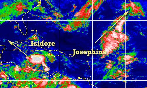
Josephine and Isidore have formed, Isidore in the Caribbean from tropical depression ten, and Josephine from tropical depression eleven in the middle of the Atlantic. Josephine will twirl red snappers, while the Isidore looks like it will be clipping the western tip of Cuba and entering into the gulf. (As of now anyway) . The big wildcard is intensity, and I fear that once (and if) Isidore starts to strengthen it will do so rapidly. Which, with current models, places it in the central Gulf, and anyones guess as to where it may wind up. This is the forecasting nightmare deluxe that we speak of.
Apologies once again as I have been away most of the week and the remainder of it. John has been writing the previous few updates and probably the next few. It will be the weekend before I'm back around.
Anyone in the gulf will want to watch Isidore. .
NRL Monterey Marine Meteorology Division Forecast Track of Active Systems (Good Forecast Track Graphic and Satellite Photos)
NASA GHCC Interactive Satellite images at:
North Atlantic Visible (Daytime Only), Infrared, Water Vapor
Some forecast models:
NGM, AVN, MRF, ETA ECMWF
DoD Weather Models (NOGAPS, AVN, MRF)
AVN, ECMWF, GFDL, MM5, NOGAPS, UKMET
Other commentary at Mike Anderson's East Coast Tropical Weather Center, Accuweather's Joe Bastardi, Hurricane City, Gary Gray's Millennium Weather, Barometer Bob's Hurricane Hollow, Snonut, Ed Dunham and Jason M in our Storm Forum Even more on the links page.
- [mike@flhurricane.com]
| JustMe |
| (Weather Guru) |
| Wed Sep 18 2002 11:29 AM |

|
|
|
Good Morning all
Here is Orlando.. I think the weathermen are holding off not commiting anything to anyone about everything. How can someone tell what to expect? Is there nothing that gives us the odds of what might be come Sunday or Monday re this storm? I have company coming and they sure don't want a hurricane. Thanks for any help.. I haven't had any replies yet when I have said something here. Would love some ideas of odds
| Unregistered User |
| (Unregistered) |
| Wed Sep 18 2002 11:31 AM |
|
|
models,models,models??? can someone explain to me why the models are now more westward in nature. is it because of the slowing down by the storm? when he finally moves again will the models then shift right? i remember they did the same thing early on and then shifted right again. i also noticed that the NHC still has the same 72 hour point as they did 12 hrs ago. can someone explain to me the impact of the troughs or lack of. thanks.
| Unregistered User |
| (Unregistered) |
| Wed Sep 18 2002 11:48 AM |
|
|
Here's a reply for ya. Sorry that you got lost in the shuffle. I think most everyone reads all the posts and probably is as confused as you with Isadore. All the bias in the models have shifted west. That's a BIG surprise for me as I expected the 2nd trof to ensure that Isadore would never be in the picture for any forecast in my area. But things change. Go read Bastardi today as he discusses the possibilities. He speculates that the first two trofs fail to pick up the storm. I figured that the 2nd one provided me shelter. Well chances are it's a 3rd trof - cross polar even brrrrrrrrr - that may end up doing the dirty work. Isidore relative to the 3rd trof next week will then make his decision.
nickd - I've noticed the same thing - left, right, left, right left. You'd think this system was under marching orders from a drill sargeant. Who knows? What we do know is there will likely be a Category 3 storm in the Gulf that could affect anyone from Mexico to Brownsville then from New Iberia to Key West. Rarely is speculation this wide with something this close in. Frankly, I still don't have a call but am hedging my only post on this storm to date from last night when I said LA was out of the woods. My 2002 target was Biloxi/Gulfport, so I guess that may be as good of a place as any 144 hours out.
Speaking of previous forecasts, yours truly, CFHC 'Weather Guru' ended up debunking Gary Gray's forecast pattern for the year, Dr. Bill Gray's numerical forecast for the year, and Joe Bastardi's landfall prediction from Appy to Buras for the year. Not bad for a blowhard amateur
Steve
| JustMe |
| (Weather Guru) |
| Wed Sep 18 2002 11:57 AM |
|
|
|
|
thanks for taking the time to answer.
I appreciate it.. I am attempting to learn all of this info that you all hand out.
thanks again and will watch the weather watchers as they work their way through this one. Looks like it is going to be really interesting.
My newsman just said maybe Flroida again. So who knows..
(laughing out loud) Could be in for some really exciting times more so than Disney or Universal have to offer.
| Unregistered User |
| (Unregistered) |
| Wed Sep 18 2002 12:05 PM |
|
|
Agree Steve, I think the models will shift again, and I have friends who are leaving for Key west Friday night wanting to know what to do!! I just can't justify the west movement. Even with the NOGAPS, it has the storm moving WSW towards mexico with no strong ridge aloft or to the north. I guess it just has it riding the backside of the front west. I cannot agree with some that say Florida is out of the woods, which I read this morning. If anything, it's the logical place for this to go, since if it drifts toward the central GOM it will eventually get picked up by a trough, if not the 2nd the final cold front. But that's my opinion. In terms of real weather, Izzy is moving NW and this motion should continue. The last recon saw a slight shift to the north of NW albeit temporary. OK, bottom line, what do I tell those going to Key West?? Arrggh!! Cheers!! Steve H.
| JustMe |
| (Weather Guru) |
| Wed Sep 18 2002 12:19 PM |
|
|
|
|
Here in Orlando the weather forcaster Glen Richards says he feels that the strom will recurve back to Florida and we will be dealing with it this weekend
Anyone else feel this way ?
| Mike |
| (Weather Watcher) |
| Wed Sep 18 2002 12:20 PM |
|
|
"Izzy" pressure is starting to drop. Down to 1004mb.
| Unregistered User |
| (Unregistered) |
| Wed Sep 18 2002 12:30 PM |
|
|
Though with a storm just a little west of there, they may well have some squally weather. I also doubt the storms turns into the peninsula - at least initially. As to the SW movement, HF posted on that last night. I think it's as likely as a LA-NW FL landfall down the line. What the trofs do (e.g. how far they dig et al) and what their effect is on the Gulf climate will have a huge say. Everything's gonna go back and forth unless the Canadian has been right all along in which case Izzy does hit FL this weekend. It appears to be the current odd model out (must have put on some weight or something
Steve
| Rasvar |
| (Weather Master) |
| Wed Sep 18 2002 12:34 PM |

|
|
|
nickd: There was a little comment in the last discussion about the model shift. Some of it seems to be just becuase the models had more data to injest.
From the discussion:
LARGE-
SCALE MODELS...AIDED BY DATA FROM THE NOAA GULFSTREAM JET MISSION
LAST EVENING...INDICATE THAT THIS RIDGE SHOULD PERSIST THROUGH 72
HR EVEN THOUGH A DEEP-LAYER TROUGH SHOULD APPROACH THE WESTERN
GULF COAST BY 72 HR. THIS PATTERN SHOULD ALLOW ISIDORE TO MOVE
GENERALLY NORTHWESTWARD FOR 48-72 HR...AND THIS IS SUPPORTED BY
ALL TRACK GUIDANCE. THE OFFICIAL FORECAST IS SLIGHTLY TO THE LEFT
OF THE PREVIOUS PACKAGE...AND IS ALONG THE RIGHT SIDE OF THE
GUIDANCE ENVELOPE.
| Unregistered User |
| (Unregistered) |
| Wed Sep 18 2002 12:38 PM |
|
|
i may be off base here but isn't this the only west based model runs in the last 48 hrs...if not more. and remember the NHC is to the right of the guidance package. they did this for a reason. they need to see some consistancy as well. any thoughts?
| wxman007 |
| (Meteorologist) |
| Wed Sep 18 2002 12:38 PM |
|
|
Notice how they ALL shifted west last night? The reason why is better data....the NOAA Gulfstream High Altitude research aircraft was sampling around the storm, and this data finally got put into the models
Not saying the more westerly tracks are right, but the model runs that incorporated that data last year were significantly more accurate.
Looking REALLY interesting...
| Unregistered User |
| (Unregistered) |
| Wed Sep 18 2002 12:41 PM |
|
|
Here is the latest recon data Wind 57knots now.
000
URNT12 KNHC 181110
VORTEX DATA MESSAGE
A. 18/1110Z
B. 17 DEG 39 MIN N
78 DEG 30 MIN W
C. NA
D. 30 KT
E. 325 DEG 019 NM
F. 062 DEG 27 KT
G. 327 DEG 013 NM
H. EXTRAP 1004 MB
I. 22 C/ 427 M
J. 24 C/ 413 M
K. 24 C/ NA
L. NA
M. NA
N. 1345/1
O. 0.2/3 NM
P. AF985 0710A CYCLONE OB 18
MAX FL WIND 57 KT N QUAD 0940Z. SLP EXTRAP FROM 1500FT.
| Unregistered User |
| (Unregistered) |
| Wed Sep 18 2002 12:49 PM |
|
|
thank you mr kelly. whats your thoughts on izzy?
| Unregistered User |
| (Unregistered) |
| Wed Sep 18 2002 12:54 PM |
|
|
The models have gone right, left, right, left, but overall the track really HASN'T changed very much. It still leans toward the tip of Cuba. The thing that has really changed is the slower movement of the storm. This could be the bigger factor, because it may let the storm intensify more. Storms in this location really don't curve back towards Florida until about a month from now. Also, the bigger the storm the straighter the line, usually. Follow the track of Camille, this may be the type of track we will see.
| Unregistered User |
| (Unregistered) |
| Wed Sep 18 2002 01:05 PM |
|
|
6z GFDL puts it in just east of N. Orleans at 108 knots. BTW Just ME didn't Glen Richards say recurve back to Florida Last Night...or was it this morning?? Cheers!! Steve H.
| Bruce |
| (Weather Guru) |
| Wed Sep 18 2002 01:18 PM |
|
|
Does anyone have the URL to the Havana radar link?
| Unregistered User |
| (Unregistered) |
| Wed Sep 18 2002 01:31 PM |
|
|
nhc model shifts back some to the right. it will slow just on west tip of cuba, trof will push back to fla. as high backs to east.
| Unregistered User |
| (Unregistered) |
| Wed Sep 18 2002 01:35 PM |
|
|
where did you get this info?
| Unregistered User |
| (Unregistered) |
| Wed Sep 18 2002 01:48 PM |
|
|
on twc, 72 hour swath of movement moved some to the right. ridge over fla. will stay there maybe to saturday , then front comes into western gulf, as high weakens over fla.
| clyde w. |
| (Storm Tracker) |
| Wed Sep 18 2002 01:49 PM |
|
|
One of the things that Bastardi often talks about is teleconnection (what's happening in the Pacific tends to teleconnect to what will happen in the Atlantic). As a novice, I'm not about to say I follow all of that, but its interesting to see that the TS in the east pac was forecast to move WNW away from the Mexican coast, but instead has moved northwest and is now forecast to move almost due North in time...so it really never followed forecast either...also never strengthened that much, but that probably doesn't relate as directly to Izzy.
| Unregistered User |
| (Unregistered) |
| Wed Sep 18 2002 01:57 PM |
|
|
This mornings path is west of where it was last night not east. All guidance shows it just off the western tip of Cuba in 72hrs. Most show it in the central Gulf thereafter with no recurving to the northeast. The first trough will definitley miss and the second probably will miss. If it does, then all bets are off and Izzy can strike anywhere, but best bets are now on the north central gulf. Looking at past seasons, there is usally a seasonal trend in the paths of storms and this year is directed towards the northern Gulf.
| Colleen A. |
| (Moderator) |
| Wed Sep 18 2002 02:03 PM |

|
|
|
I think that we should stock up on Rolaids immediately. This is going to be a loooonnnnnggggg week/weekend. I would NOT rule out Florida based on one model run, even if they ALL agree. I'm not a met, but even I know enough by now that you cannot rely on a single model run for track guidance. I think that's why the NHC has shifted the track to the west a bit by still is to the right of the "guidance envelope". The longer it sits out there meandering about, the more difficult it will become to predict a landfall with certainty. And..another thing to remember...even though they (the models) have shifted it west a bit, IF it becomes a major hurricane and even just brushes the western coast of Florida, it could still be a very bad weekend. Look what Floyd did to Jax ...and does anyone remember Georges? Here in Lakeland, we had tornadoes all day long, and he was off the coast.
| Unregistered User |
| (Unregistered) |
| Wed Sep 18 2002 02:06 PM |
|
|
ridge weakens over fla. trof moves east it wont move north, upper level winds will be southwest.
| clyde w. |
| (Storm Tracker) |
| Wed Sep 18 2002 02:10 PM |
|
|
Good point Colleen. Models have shifted west, but we need to see some run to run consistency before jumping to any conclusions.
| Bruce |
| (Weather Guru) |
| Wed Sep 18 2002 02:14 PM |
|
|
SAT-TUE...PERIOD COMPLETELY DEPENDENT ON TRACK OF THE TD/TS OR EVEN
HURRICANE BY THIS POINT. THE GFS KEEPS THE H5 RIDGE OVER FL THROUGH
THE WEEKEND AND IS INDICATING A MORE WESTWARD TRACK IN THE EXTENDED
PERIOD. WILL BE INTERESTING TO SEE WHAT NHC HAS TO SAY. IF THE GFS
VERIFIES WILL BEGIN DRYING OUT SUN AS THE SYSTEM MOVE WEST AWAY FROM
THE AREA AND WIND MAY BE LESS OF A FACTOR...BUT SHOULD NOTE UPR
PATTERNS SEEM TO FAVOR THE CEN GULF MORE AND NOT BUYING THE WSW MVMT
OF THE GFS. GIVEN THE HIGH UNCERTAINTY WILL NOT DEVIATE FM THE
CURRENT FORECAST...SHOWING CHC/SCT POPS THRU MON AND WINDY
CONDITIONS OVR THE WEEKEND.
Melbourne forecast
| Unregistered User |
| (Unregistered) |
| Wed Sep 18 2002 02:15 PM |
|
|
colleen your right, plus you have to go with what features are around at the time not with past history. there is a ridge over fla. right now but it may not be there when izzy is there .because hes going so slow, ridge will be gone and trofs will be coming down . mark im in fla. too
| andy1tom |
| (Storm Tracker) |
| Wed Sep 18 2002 02:42 PM |

|
|
|
http://www.net-waves.net/weather/td10.php
If these came out just a couple of hours ago I don't see a whole lot of change in the forecast. Am I missing the boat or is this old info??
| Unregistered User |
| (Unregistered) |
| Wed Sep 18 2002 02:43 PM |
|
|
colleen, starting to get good banding from the southwest. this thing is gonna pop soon. also looks like it may be goin more nnw than northwest. that would change everything, like bastardi said just dont look at models look at whats out there.
| JustMe |
| (Weather Guru) |
| Wed Sep 18 2002 02:51 PM |
|
|
|
|
Heard it on k92 radio this am just prior to my note here
Now I am really confused. Visitors come. go .come. go
We will see tomorrow...
thanks for all the help
| Unregistered User |
| (Unregistered) |
| Wed Sep 18 2002 02:58 PM |
|
|
I've been noticing a more nnw movement, maybe its just my eyes! THOUGHTS???????
Jeanine/Hollywood
| Unregistered User |
| (Unregistered) |
| Wed Sep 18 2002 03:00 PM |
|
|
Watching the morning Sat loops. It appears that movement is NNW rather than wnw. Got a gut feeling that South Florida could be in trouble. Need to wait another day or so before we will know for sure. Great board, keep up the fun discussion.
Steve
South Florida
| scottsvb |
| (Weather Master) |
| Wed Sep 18 2002 03:01 PM |
|
|
i agree with a good call by Hankfrank on seeing the Nogaps was right. Almost all the models including the AVN that i like best next to the Nogaps has it up off cuba by Friday, missing the trough as it lifts out and a weak short wave, then moves it off to the W or even wsw as ridge comes screaming down to the northern gulf, plus with a strong hurricane forcasted to be there a general pick up in speed of around 8 then 12 mph will take shape late sunday into next week. Heading right towards Tampico. Cant say it will make landfall there like I few days back said tampa-Miami as most of us did feel the shortwave trough behind will push it off to the NE. But the system slowed enough to miss the full timing. Remember last Saturday models had it today crossing Cuba and 2 had it ENE of there near the Bahamas. So now to say it will hit Tampico in 6-7 days is like guessing 5/6 numbers in the lotto.
General Conditions show heavy showers and T-storms over Jamaica, reports from Kingston int show S and E parts of the island reporting winds near TS strength in squalls. Latest pressure as of now is 1004mb winds near 45 but could be up to 50 by 11am. Movement has been a wobble to the NW and should at times move NNW and be near G Cayman late tonight and near S end of Cuba Thurs. Should cross the state near 82W later Thurs night into Friday. and meander Saturday moving little as the trough moves out. Should be a hurricane by tomorrow afternoon. After that the models take the system W. Only chance florida has is if Isadora moves more NNW during the next 48 hours and crosses Cuba E of 81 to south of Keywest. Then it might have enough eastward placement to keep it in the eastern Gulf or have it cross florida from later Sunday or early next week. Timing is everything here. I am acknowledging the models more though watching this trough more then Isadore. The N central gulf is in the picture too BUT wont be for many days. If she misses the trough and gets caught by the strong ridge later sunday and monday she will move W. Another trough will come down next week and according to next mid weeks flow will come then out of the W and SW pushing the weakening by then Cat 3 120mph Isadore N then NE into the N central Gulf states as a strong Cat 1. So different possibilities here. Florida folks you need to see a N movement or NNW during the next 2 days then if not a W movement that could go right into the Tampico area by Midweek, or the next trough will catch the storm in the sw gulf and turn it NNE. New 11am says still 45mph. Increase those winds by 80 in the gulf on Saturday. scottsvb hurricaneupdatecenter
| Unregistered User |
| (Unregistered) |
| Wed Sep 18 2002 03:01 PM |
|
|
Statement as of 11:00 am EDT on September 18, 2002
we are in a brief gap between reconnaissance aircraft this
morning...but satellite imagery indicates that Isidore continues to
organize...with the development of a curved band south of the center
and a burst of deep convection very close to the center. The next
aircraft will almost surely find a well-defined center for the first
time and increased winds should follow rather quickly. Conditions
appear conducive for significant strengthening once a well-defined
center develops.
There has been no change to the track forecast or thinking. The
initial motion is 315/6. In the short term...guidance is in good
agreement on a continued northwesterly track. Things get
interesting near the end of the forecast period when a mid-to upper
level trough swings into the northwestern Gulf of Mexico. Timing
will be everything as to whether Isidore has moved far enough into
the Gulf to be picked up by the trough...or left behind. The
current official forecast calls for only very slow motion at the end
of the forecast period. At this point...no portion of the Gulf of
Mexico coastline can be ruled out as a potential ultimate landfall.
Forecaster Franklin
forecast positions and Max winds
initial 18/1500z 17.9n 78.7w 40 kts
12hr VT 19/0000z 18.7n 79.5w 45 kts
24hr VT 19/1200z 19.9n 80.8w 55 kts
36hr VT 20/0000z 21.1n 82.1w 65 kts
48hr VT 20/1200z 22.5n 83.5w 75 kts
72hr VT 21/1200z 23.5n 84.5w 80 kts
| HanKFranK |
| (User) |
| Wed Sep 18 2002 03:03 PM |

|
|
|
this morning.. has the look of a system that will deepen rapidly after the core organization improves just a little more. may in fact be a hurricane this evening... wouldnt mind that since i said it would yesterday morning. to me the intensity forecast is a no brainer.. this will be category 3-4 by the weekend. nothing to stop it. problem is track.
all of those neat recurvature solutions from the weekend were based on the storm already being strong yesterday, already being well ahead of its current position. the slow speed and slow, jumpy intensification have sort of ruined the easy recurvature solution. problem now is, the shortwaves leading the really big high coming down from western canada next week may not be enough to tap the ridge out of the way and give izzy a path. they might just skim by and then leave a mid layer ridge intact across the gulf. the rapid SW movement.. i wont entirely discount. does anyone remember iris last year? the reason it blitzed westward across the caribbean was because a massive longwave and surface high built down over the states and blocked its recurvature. same issue here.. if izzy takes it slow and easy, path ahead may be blocked.. and though i think the westward movement is overdone.. that would surely remove florida from the crosshairs.
so basically.. there are a couple more shortwaves for izzy to latch on to.. after that a big longwave trough will make an impermeable barrier across the gulf unless something unforseen on the subtropical jet flow from the east pacific comes along and nudges izzy back or holds it in place until the 3rd amplification.. bastardi's super cold shot late week.. comes to get it. obviously we're talking over a week away.. by then the storm could have already hit florida early, somehow charged its way into the upper gulf ahead of the longwave (hard to buy that one), turned left and sped into mexico.. or just meandered in the southern gulf like opal.
if isidore was just a day ahead of its movement and intensity, this would be a cut and dry florida landfall. but the storm has waited and may miss the chance to phase in the eastern gulf.. and end up never doing so, or just waiting another week.
HF 1454z18september
| scottsvb |
| (Weather Master) |
| Wed Sep 18 2002 03:31 PM |
|
|
good forcasting again hank.
| Unregistered User |
| (Unregistered) |
| Wed Sep 18 2002 03:40 PM |
|
|
what is the time frame with the troughs? where does izzy have to be to catch them?
| Unregistered User |
| (Unregistered) |
| Wed Sep 18 2002 04:11 PM |
|
|
Timing is everything....absolutely. Interesting that he seems to have a more northerly component during the last 3 hours, more like 320/325...could be temporary, but there seems to be a weakness to the north where it's bulging as it gets organized. Let's see if it stays east of Grand Cayman. If the weakness is to the north (as some of the flow seems to indicate) it may allow him to increase forward speed for a while. All playing into the factor of the timing issue. I wouldn't say the "only chance" for Flrida landfall is if this NNW motion continues; we just don't know that yet Scott. There are many variables. That's not to say Florida is the target, but we don't know the strength of the trough progged to come in over the weekend, and the effect it will have on Isidore with the SW flow ahead of it. This will change 10 times before Friday. I do fear if it goes further north quicker and does target SW Florida, that the notice may to too late to Evacuate if it's a major storm. nail biting time here. Cheers!! Steve H.
| troy2 |
| (Storm Tracker) |
| Wed Sep 18 2002 04:23 PM |
|
|
http://www.ssd.noaa.gov/PS/TROP/DATA/RT/watl-ir4-loop.html
this loop may illustrate what steve mentioned.
Notice the convection aroun dthe Keyes and points further south being 'pushed' north with what seems to be part of this storms environment or a weakness to the ridge or a combo of the two.
Meaning the outflow is pushing convecrtion north and there is not enough ridge to block that stray convection or divert it.
I am probably way off so bare with me!
Still in kindergarten here with regards to my weather schoolage
| Unregistered User |
| (Unregistered) |
| Wed Sep 18 2002 04:38 PM |
|
|
also think bout this could stall just south of cuba, and as trof digs,rapid intensification, and gets tugged north , and roars thru straits and keys and right up the middle of fla.
| scottsvb |
| (Weather Master) |
| Wed Sep 18 2002 04:40 PM |
|
|
Yes a NNW motion will infact be the only chance for a florida landfall. If this does happen then this will bring the system closer to the Fla straits and give it a chance to catch the trough. The trough is strong entering the NW gulf later on Thurs but will weaken over the next 48 hours after that and will lift out Sunday with a ridge over the N Gulf across N florida. We dont know though how strong the ridge will be yet on this. Anyways, Im a met , I would like to see this come to florida. LOL. scottsvb
| Unregistered User |
| (Unregistered) |
| Wed Sep 18 2002 04:53 PM |
|
|
The local feed from the weather channel ran a scrawl an hour or so ago in orange saying that Florida's weather would be effected later this week by Tropical Storm Isidore. This concerns me because usually here in mouse country the merchants will not allow negative weather to be discussed unless you can look out the window and see the rain coming down. I hope that this was just an overzelous bored computer data input operator and not a serious decision. Florida has bogus elections we dont need hurricanes too.
| ShawnS |
| (Storm Tracker) |
| Wed Sep 18 2002 04:54 PM |
|
|
I've said it all along and I will say it ONE more time. It will be a western gulf problem or bust. You people act like this has not been predicted by anyone yet. I said it 2 days ago. I have learned my lesson about paying attention to models. Let's see what happens.
| Unregistered User |
| (Unregistered) |
| Wed Sep 18 2002 04:58 PM |
|
|
I could be seeing things, but watching the Vis Loop it appears that the LLC is relocating about 100 miles to the WNW of Jamaica. My eyes may be playing tricks but it really looks like the center is reforming just south of all the deep convection NW of Jamaica. Anyone else see this?
| Unregistered User |
| (Unregistered) |
| Wed Sep 18 2002 05:03 PM |
|
|
Looking at the WV loop:
http://www.ssd.noaa.gov/PS/TROP/DATA/RT/float-wv-loop.html
It looks like the center of circulation is moving NNW, any thoughts on this.
| Unregistered User |
| (Unregistered) |
| Wed Sep 18 2002 05:12 PM |
|
|
no way to know for sure after 72 hours where this is going. look at it right now its moving more nnw than nw. 72 hour swath has also moved more to the right also. and every degree it moves more north the stronger the threat to the keys and fla. very scary a major hurricane to the keys.
| Unregistered User |
| (Unregistered) |
| Wed Sep 18 2002 05:20 PM |
|
|
yes. like i said earlier its moving mainly north just a little west. that would change everything. and this thing is getting ready to explode. look at what you see, not at what a computer shows.
| Unregistered User |
| (Unregistered) |
| Wed Sep 18 2002 05:22 PM |
|
|
Good posts, very informative. I am a noob to this site, but an avid weather fan in Miami. Can any of you direct me to sites where I can view the individual models, so as to join in the discussion? Thank you.
Also, I haven't seen any comments about the weakening of the storm as it passes Cuba. I took a look at the topography of Cuba last night, and it does appear that if the storm continues NNW, and passes East of Havana, the mountains are much smaller than if it passes west, or further east. In any event, if the NNW trend continues, is it possible the storm will be torn apart in Cuba?
| Unregistered User |
| (Unregistered) |
| Wed Sep 18 2002 05:25 PM |
|
|
I have been trying all morning to see this nnw motion. It looks to me to be moving nw right in line with previous paths predicted by the NHC. Izzy does look like he is getting much stronger. I would not be surprised to see a hurricane by tonight. Still believe this one will become a monster and will be somewhere in the central gulf in 96 hours still moving northwest. I think what you guys are seeing as a northerly turn is simply the expanding of the CDO. If you look, it is expanding westward as well.
| Unregistered User |
| (Unregistered) |
| Wed Sep 18 2002 05:28 PM |
|
|
depending where it crosses and at what forward speed it is going. but sraits and gulfstream are very warm waters!
| Unregistered User |
| (Unregistered) |
| Wed Sep 18 2002 05:29 PM |
|
|
Please note that there is every chance the storm center will miss Miami but the weather system ie RAIN will still affect it and I think its very responsible to advise people that our weather will be affected and isn't hype.
Trust me.. if it goes into the Gulf everyone will go back to the Dolphins and the beach and the Air Conditioned Mall faster than Debby disappated.
But, rather safe than sorry. It isn't heading WNW currently and think their concern was the more NW bearing and look of intensifying via banding.
Bobbi
| Unregistered User |
| (Unregistered) |
| Wed Sep 18 2002 05:30 PM |
|
|
Good comment about nail biting.. I just realized I don't have water and usually I do and usually nothing happens.
Oops.. Bobbi
| Unregistered User |
| (Unregistered) |
| Wed Sep 18 2002 05:31 PM |
|
|
Can be seen in last few frames.
Also, Hanna is off NC, trying for a comeback, very skeletal at the moment.
Stay tuned..Is has a few tricks up his sleeve yet.
IHS,
Bill
| Colleen A. |
| (Moderator) |
| Wed Sep 18 2002 05:33 PM |
|
|
|
|
First to Mary: I saw that too, and you are correct in saying that they usually don't mention that. The fact that they are concerned about the Peace River flooding in Bartow tells a tale in itself. They must be thinking that it will be near enough to our coast line here that we will at the very least get the feeder bands which will directly affect our weather.
Correct me if I am wrong, but didn't the NHC say that EVERYONE from Mexico to Florida should be watching this carefully? That tells me one thing: that THEY are looking for consistency in the runs and they are not getting it. It is indeed just below the Keys in 72 hours, if you plot the coordinates. It also appears that it has taken a jog a bit more to the NNW as it is closer to Jamaica than it was predicted to be BY the models. I believe that would be why the NHC official track is to the RIGHT of the guidance envelope. I have not seen them mention one single time that Florida is out of the woods, and until they do I am not writing this one off.
Another thing: if it is moving at 7mph, it's not the fastest storm I've ever seen but it IS moving. Which means that it will be going SOMEWHERE for at least another day. The strike probablities went up for Key West from 17% to 22%; Tampa from 7% to 10%. If they thought this was going to turn to the west as dramatically as some here think it is, those probabiliies would have gone down, not up. For the time being, until given the all clear by the NHC, all residents along the GOM from Texas to Florida should be watching this thing very carefully. It may go west at some point, but for now the uncertainty is too great to just blow it off. To do so would be foolish and unless someone here is equipped with a crystal ball, I don't think any of us know for certain where it will go.
Timing and position will be the key here. If it moves further north faster, watch out Florida. If it slows down dramatically, everything is up in the air. We don't know the answers to a lot of questions yet, that's for sure. But if it DOES make it's trip to the north quicker, it's going to get messy here in Florida.
| Unregistered User |
| (Unregistered) |
| Wed Sep 18 2002 05:33 PM |
|
|
just saw latest sat. photo and twc said it is moving more to north than nw.
| Unregistered User |
| (Unregistered) |
| Wed Sep 18 2002 05:41 PM |
|
|
I can do a water vapor loop better than so many but I am braindead when it comes to remembering my password for this site (and yes I asked for it to be sent to me... sorry Hurric.. I'm trying)
Anyway...excellent thoughts Steve and someone else a while back on the loops... very interesting set up..in some way Carib storms are more interesting with more possibilities than the usual Cape Verde recurvature questions.
So... here are my thoughts.. and an interesting webcan on Bear Cut that was made by a storm in 1835 with a similar path as Isidore..
http://www.rsmas.miami.edu/media/msc-webcam/
1 Things are about to change.. there is banding and signs of NNW movement though granted this storm stair steps everywhere..
2 Point at which the trof is digging or will soon dig is equal distance with the ULL that has pulled west. Combined with the digging trough behind it which is almost at the same latitude now and still digging as weak Isidore has it caught in the flow.. come on..it is almost stalled which means there are forces battling for its attention. The trough isn't going to stop digging anytime today whereas the ULL is moving further out of the picture.. Those 3 things add up to the storm beginning to move NNW (being conservative here)as a building storm and hitting Cuba dead on as a hurricane or near hurricane strength.
3 If the storm had moved west then there would be more concern for it to bomb ala Gilbert type of storm but on the present path closer to the Cuban coast there will be interaction between Jamaica and Cuba's more moutainous terrain on its NE-N side and that will inhibit it from exploding as some had predicted.
4 Remember earliest runs of this storm because it has followed the early model runs for when it was down in Trinidad doing the Limbo dance
5 Motion with this storm has been a jog more west..than a build up of convection to the NE and then that convection wraps to the north around the cdo which ends up with a smoothed out motion of NW
6 I said Mobile should watch yesterday partly in jest and partly for real because if it were to be pulled into the Gulf I don't see it moving as far west as models today indicated and any time you have a Carib hurricane to your south you SHOULD be watching.
We all should be watching.
Lastly.. I find sometimes storms follow the original models more closely in retrospect than the in between pulls L and R of the track..
Anyone see the AVN today.. usually would count it out but find it possible.
http://www.rsmas.miami.edu/media/msc-webcam/
| Unregistered User |
| (Unregistered) |
| Wed Sep 18 2002 05:49 PM |
|
|
hi colleen, like we have said here before. look at what your eyes see and not what a model says. models can change. i lived in miami in the 60's and this reminds me of cleo and inez. very scary senario for keys especially, a major hurricane going thru there. and as you know only one way out of there. they have to know early to get out from down there.this one could go thru keys and straight up the middle of fla. also sure miss john hope. dont you. mark. sebring, fla.
| Unregistered User |
| (Unregistered) |
| Wed Sep 18 2002 05:54 PM |
|
|
I wish Izzy would hurry up and get an eye so we could end all of the speculation of current movement and be able to easily track him.
| Unregistered User |
| (Unregistered) |
| Wed Sep 18 2002 05:58 PM |
|
|
I agree with ya Colleen. What is the causal factor that takes the storm on a sharp turn to the w, even wsw, after 60-72 hours on the NOGAPS? And anyone else notice that the storm takes a turn to the North on the NOGAPS at 48 hrs., followed by the sharp W turn? Any explanations?
Like you Colleen this one still concerns me. My biggest concern is the strength. I have to say, I am usually very conservative when it comes to Hurricanes bearing down on Florida, as they generally seem to turn away, but in terms of strength....this one makes me nervous. I just have a bad feeling it may indeed explode in intensity...especially if the high pressure builds over it as predicted. These are super-heated waters down there....
| andy1tom |
| (Storm Tracker) |
| Wed Sep 18 2002 05:58 PM |
|
|
|
|
I am in agreement with some earlier posters that it looks like the center is relocating. Almost looks like the system is going to split into two.
| Unregistered User |
| (Unregistered) |
| Wed Sep 18 2002 06:06 PM |
|
|
2 PM advisory has winds now up to 50 mph.
| andy1tom |
| (Storm Tracker) |
| Wed Sep 18 2002 06:06 PM |
|
|
|
|
WTNT35 KNHC 181743
TCPAT5
BULLETIN
TROPICAL STORM ISIDORE INTERMEDIATE ADVISORY NUMBER 10A
NATIONAL WEATHER SERVICE MIAMI FL
2 PM EDT WED SEP 18 2002
...ISIDORE SOAKING JAMAICA...BEGINNING TO STRENGTHEN...
AT 2 PM EDT...1800Z...THE GOVERNMENT OF THE CAYMAN ISLANDS HAS
EXTENDED THE TROPICAL STORM WARNING TO INCLUDE GRAND CAYMAN. A
TROPICAL STORM WARNING IS NOW IN EFFECT FOR ALL OF THE CAYMAN
ISLANDS.
A HURRICANE WATCH REMAINS IN EFFECT FOR WESTERN CUBA...FROM THE
PROVINCES OF VILLA CLARA AND CIENFUEGOS WESTWARD...AND INCLUDING THE
ISLE OF YOUTH.
A TROPICAL STORM WARNING REMAINS IN EFFECT FOR JAMAICA.
AT 2 PM EDT...1800Z...THE CENTER OF TROPICAL STORM ISIDORE WAS
LOCATED NEAR LATITUDE 18.2 NORTH...LONGITUDE 78.9 WEST OR ABOUT 35
MILES ...50 KM...WEST OF THE WESTERN TIP OF JAMAICA. THIS
POSITION IS ALSO ABOUT 175 MILES ...285 KM...EAST-SOUTHEAST OF GRAND
CAYMAN.
ISIDORE IS MOVING TOWARD THE NORTHWEST NEAR 7 MPH
...11 KM/HR...AND THIS MOTION IS EXPECTED TO CONTINUE FOR THE NEXT
24 HOURS. EVEN THOUGH THE CENTER OF ISIDORE WILL BE MOVING AWAY
FROM JAMAICA THIS AFTERNOON...CONDITIONS THERE WILL BE SLOW TO
IMPROVE SINCE MOST OF THE HEAVY RAINS AND WINDS ARE LOCATED TO THE
EAST OF THE CENTER.
MAXIMUM SUSTAINED WINDS ARE NEAR 50 MPH... 80 KM/HR...WITH HIGHER
GUSTS. ISIDORE IS EXPECTED TO STRENGTHEN DURING THE NEXT 24 HOURS.
TROPICAL STORM FORCE WINDS EXTEND OUTWARD UP TO 85 MILES
...140 KM ...MAINLY EAST OF THE CENTER.
ESTIMATED MINIMUM CENTRAL PRESSURE IS 1002 MB...29.59 INCHES. A NEW
AIR FORCE RESERVE UNIT HURRICANE HUNTER AIRCRAFT WILL BE REACHING
THE CENTER OF ISIDORE WITHIN THE NEXT HOUR.
HEAVY RAINS ARE EXPECTED TO CONTINUE OVER JAMAICA DURING THE NEXT 24
HOURS...AND THESE RAINS COULD CAUSE LIFE-THREATENING FLASH FLOODS
AND MUD SLIDES. HEAVY RAINS ARE NOW MOVING INTO THE CAYMAN ISLANDS.
REPEATING THE 2 PM EDT POSITION...18.2 N... 78.9 W. MOVEMENT
TOWARD...NORTHWEST NEAR 7 MPH. MAXIMUM SUSTAINED
WINDS... 50 MPH. MINIMUM CENTRAL PRESSURE...1002 MB.
FOR STORM INFORMATION SPECIFIC TO YOUR AREA...PLEASE MONITOR
PRODUCTS ISSUED BY YOUR LOCAL WEATHER OFFICE.
THE NEXT ADVISORY WILL BE ISSUED BY THE NATIONAL
HURRICANE CENTER AT 5 PM EDT.
FORECASTER FRANKLIN
| Unregistered User |
| (Unregistered) |
| Wed Sep 18 2002 06:10 PM |
|
|
Also notice the motion is indeed NW.
| Jax Chris |
| (Weather Watcher) |
| Wed Sep 18 2002 06:11 PM |
|
|
Brett asked, "Can any of you direct me to sites where I can view the individual models...?" The first post that starts any of these threads has several links at the bottom, under the heading "Some forecast models:". The links here will take you to the AVN, MRF and other models, and the DoD models link will take you to a page where you can request UKMET, NOGAPS and other models. There are also links below those to other discussions, such as Joe Bastardi, who is often mentioned here. There are also many links on the 'Storm Links' link on the navigation bar on the left of the screen.
Hoping I don't get a back-door hit from Isidore...
Jax Chris
| Hurric |
| (Weather Guru) |
| Wed Sep 18 2002 06:13 PM |

|
|
|
Good posts, With a Storm south of Florida with shfting models and slow movement no one should be quick to make any decisions other than to keep monitering and see how it finally unfolds.
There are some people making some very good posts on this board with well thoughtout reasons supporting their thinking on the future of Isadore. These are both interesting to read and educational . I am sure most if not all them would be the first to tell the less experienced and knowledgeable to use their own eyes and to follow the official recomendations.
As pointed out by Bobbi, Colleen and others you dont need a direct hit to have your weather greatly affected. This is especially true with a storm as strong and large as this one looks like it will be.
As for me, I'll be watchin, waitin, and spending to much time,"trying to reason with Hurricane season"
Hurric
| clyde w. |
| (Storm Tracker) |
| Wed Sep 18 2002 06:13 PM |
|
|
Tracking coordinates from 5 a.m. until 2 p.m. shows a 1.0 degree northward movement, and a 0.6 degree westward movement (cumulative). Over the past 9 hours, Izzy has moved more NNW than NW just based on coordinate history.
| andy1tom |
| (Storm Tracker) |
| Wed Sep 18 2002 06:16 PM |
|
|
|
|
http://www.net-waves.net/weather/tropics.php
Brett here is another site that has some tropic info
| Colleen A. |
| (Moderator) |
| Wed Sep 18 2002 06:21 PM |
|
|
|
|
Brett...if the NOGAPS is doing that, then either it knows something we don't or it's completely out to lunch. If ALL the models were doing it, okay. Is it only that one?
Mark..yes, I do miss John Hope and I wish we had more forecasters like Brian Norcross who warned Miami about Andrew. He was the only one that I know of who even went there...and he was right.
Here's a very good indicator of where the storm will make landfall: look for Jim Cantore. Wherever HE is, that's where they go. I don't care if the models said Houston, if he was in the Keys, that's where it would go.
I will be interested to see what RECON reports when they get to the center. This storm is very unnerving to say the least. I've always heard it said (mainly from John Hope and some of the old NHC Directors) that your area is never out of the woods until it passes your lon/lat coordinates. That's when you can breath a sigh of relief.
| andy1tom |
| (Storm Tracker) |
| Wed Sep 18 2002 06:29 PM |
|
|
|
|
but breath quickly because they can do the ol' loopity loop
| Colleen A. |
| (Moderator) |
| Wed Sep 18 2002 06:33 PM |
|
|
|
|
LOL, Andy! Quick wit you have! ;-)
| Unregistered User |
| (Unregistered) |
| Wed Sep 18 2002 06:52 PM |
|
|
andy great site waves.net. izzy getting stronger on every photo banding starting to come in from the nw, around center. on that page a98 e model looks intresting. potential track from nhc moving little more east each one. mark
| andy1tom |
| (Storm Tracker) |
| Wed Sep 18 2002 06:57 PM |
|
|
|
|
looking at the key west radar it appears they are some rain showers on the way. are these outer bands from izzy or from something else? also with a hurricane watch for west cuba do you think t/s watch or warning will be issued for the keys later?
| Kevin |
| (Weather Master) |
| Wed Sep 18 2002 07:01 PM |

|
|
|
First of all, I'd like to tell you all that you need to probably take the models as a very, very fine grain of salt at this point. I have noticed that some models force the storm westward with no ridge above it at all...that's just plain whacked. Doesn't happen too often.
Another thing I urge my fellow Floridians to look at is climatology. How many storms in the past have missed troughs at this time in September while in the GOMEX? Not too many, if any at all. Climatology simply shows that this storm will, in the end, effect Florida. Not wishcasting here, just giving the pure facts. *IF*, and I mean *IF* the trough picks this storm up, it will likely make landfall in the Big Bend area. Subject to change, of course. But given the pretty large size of this storm Central Florida would likely get some hurricane conditions.
If this storm intensifies to a major hurricane...and it likely will...it should move north at 5-10 mph. This brings the possibility of this storm moving north and meeting the trough will no problem. Once again, just another scenario.
My final word: It still looks to me like Florida is the main threat for Florida. Although the chances are somewhat high along the northern GOMEX, the storm should clear just to the east of here. It is going to be a stomach-churning weekend here, but in the end, I think Isidore will be a Florida storm.
Let's see what happens...pressures also starting to fall. Also, any NNW movement could shift the track to the right. I feel that as Isidore begins to develop an eye tomorrow, there will be flucuations to the NNW due to wobbling, common in weak hurricanes. Watch for that.
Kevin
| Unregistered User |
| (Unregistered) |
| Wed Sep 18 2002 07:01 PM |
|
|
We all kind of want and don't want a piece of this action, but there is no NNW movement today. In fact, the change in the official position from the 11am advisory and the 2pm advisory is a slope of 3/12 (1/4) which puts it halfway between WNW and due West - that is for every tenth of a degree it's moved north, it's moved 4 tenths of a degree west. The only reason it looks like a NNW motion is because some of the convection is riding on in from the E and NE potion of the system. A recon is supposed to be there within the hour, so it will be interesting to see if they plot it differently than the NHC has.
Steve
| Kevin |
| (Weather Master) |
| Wed Sep 18 2002 07:03 PM |
|
|
|
|
Andy1Tom: No TS/Hurricane watching and warnings for 48 hours AT LEAST. This is also barring any major center relocation, of course. Like myself and other are saying, this will be a nail-biter of a weekend. We're on pins and needles for now.
| doug |
| (Weather Analyst) |
| Wed Sep 18 2002 07:03 PM |
|
|
for whatever it is worth...IMHO the sat pics confirm a path slightly right of the NW diection and if this does not deviate the storm should impact Cuba east of the Cayman...but we all know how that goes...the environment ahead seems to suggest, at least for now, that upper steering is predominantly from south to north, at least that is the direction the high clouds over extreme western Cuba seem to be blowing...the low level SE fetch around the ridge is supposed to be the dominant steering mechanism for now, but the more northerly movement than the initialization predicted may be because the storm is feeling that S to N upper air push...have to see if that backs off too in the same way the upper low did as that may be related to that feature as well. As I looked at all the models, the ones that have the storm move the quickest take it into west Florida...the others hold it back into the central gulf for a couple of extra days and the it is pushed back NE...only one throws it west into Mexico... the forward motion is fairly deliberate now which favors no quick (72hrs) landfall in US. EDS.
| troy2 |
| (Storm Tracker) |
| Wed Sep 18 2002 07:16 PM |
|
|
11am 17.9n 78.7w
2pm 18.2n 78.9w
just a tad right of NW
| Unregistered User |
| (Unregistered) |
| Wed Sep 18 2002 07:18 PM |
|
|
there has been a nnw movement today just saw it posted here and ive been watching loops and center has moved more nnw than nw recently.
| Unregistered User |
| (Unregistered) |
| Wed Sep 18 2002 07:19 PM |
|
|
slope is 3/2 NNW. 17.9 78.7 to 18.2 78.9. Goes to show what getting coordinates when talking to someone else at the same time does for writing stuff down. I'm a distracted cell-phone talking driver. Pardon that last post which I can't delete since I wasn't logged in to post it. BAH!
My bad.
Steve
| troy2 |
| (Storm Tracker) |
| Wed Sep 18 2002 07:20 PM |
|
|
thats ok steve just owe us al a round on you!
I drink Guinness! and Hey I'll buy the 2nd round!
Troy
| Unregistered User |
| (Unregistered) |
| Wed Sep 18 2002 07:20 PM |
|
|
Delete my No NNW movement post please. Usually I'm pretty careful with this stuff, but uh, I blew it.
Thanks,
Steve
| Steve |
| (Senior Storm Chaser) |
| Wed Sep 18 2002 07:26 PM |

|
|
|
I like Guiness too, but I prefer Harp. Anyway, I wrote down 79.9 instead of 78.9. Someone was in here talking about how the Tyco execs may be locked up tomorrow and I was halfway paying attention to them while trying to get the coordinates. BONEHEAD move.
Steve
| Mike |
| (Weather Watcher) |
| Wed Sep 18 2002 07:27 PM |
|
|
I will buy the third!!!
| Unregistered User |
| (Unregistered) |
| Wed Sep 18 2002 07:29 PM |
|
|
Thanks guys for the good sites and information. I indeed located the models within the first post, and thats where I got the information from NOGAPS. I agree with ya Colleen...my tone was intended to be a bit sarcastic. I really wanted to know what was the "influence" that turned the system West after 72 hours in the nogaps model, since I truly can't figure out why it has it shifting so sharply in that direction.
As for the northward jog, I can't explain that either, although I admit I am not a scientist by trade. Can anyone shed some more light on the competing factors we have here, and more importantly, on the intensity forecasts?
Brett
| Unregistered User |
| (Unregistered) |
| Wed Sep 18 2002 07:29 PM |
|
|
steve its ok, i have noticed it takes awhile even for nhc to state a movement, we have seen in their advisories.
| Unregistered User |
| (Unregistered) |
| Wed Sep 18 2002 07:40 PM |
|
|
man.... this thing is starting to wrap around the west side of it too, east side already has, i think this could be a hurricane even this evening. earlier in nhc discussion they said they might be underestimating the strength forecast, i think the guy was right. gfdl said rapid strengthining down the road .......127+++++ scary! mark
| troy2 |
| (Storm Tracker) |
| Wed Sep 18 2002 07:43 PM |
|
|
looks like forward speed may have increased just a tad
| andy1tom |
| (Storm Tracker) |
| Wed Sep 18 2002 07:44 PM |
|
|
|
|
when should we expect the data from the recon flight??
| Kevin |
| (Weather Master) |
| Wed Sep 18 2002 07:52 PM |
|
|
|
|
I observed three things:
1. I did see a more NNW jog than NW in the last two frames.
2. The forward motion did look a tad faster on the last frame. It sort of looked like the storm "jumped" forward.
3. The worst observation of them all. This baby is really starting to wrap-up. A central dense overcast is evident on the imagery and banding is starting to take place. System also trying to get larger.
Also read new NWS Melbourne discussion. They said we will "at least" see indirect impacts from the storm. I have a feeling that Central Florida will, at the very least, see some strong rainbands from this system. I'm also concerned about northward wobbles as Isidore develops an eye. Looks like this storm is going to be very wobbly.
Just looked at model runs again and I thought, "Yeah right." If you notice all of the models that turn the storm west do so sharply. This is highly unrealistic. Any turn, be it NE or W, will be a a somewhat gentle turn. Still can't believe the models given the itensity of the trough coming down and the possibility of a quicker-moving storm.
Thoughts and comments welcome.
Kevin
| Unregistered User |
| (Unregistered) |
| Wed Sep 18 2002 07:55 PM |
|
|
look at key west weather discussion, high pressure ridge over fla. will weaken and move out, opening the door for the strong trof coming down.
| JustMe |
| (Weather Guru) |
| Wed Sep 18 2002 08:02 PM |
|
|
|
|
Any more ideas about Flroida Yet ?
| Rasvar |
| (Weather Master) |
| Wed Sep 18 2002 08:03 PM |
|
|
|
|
If this sucker is picking up forward speed and going more northerly, I am not too thrilled. To me, the sooner it gets to the Gulf, the better the chance of a recurve into South or Central Florida. I will be watching intently. That is for sure.
| Unregistered User |
| (Unregistered) |
| Wed Sep 18 2002 08:07 PM |
|
|
just me... look at key west weather discussion.
| Unregistered User |
| (Unregistered) |
| Wed Sep 18 2002 08:10 PM |
|
|
I am curious to know if anyone is a meteorologist? Very interesting discussion and it appears the plot is thickening with this storm. Anyone have links where I can see a larger Water Vapor picture/loop than the one at the NHC site?
| Kevin |
| (Weather Master) |
| Wed Sep 18 2002 08:10 PM |
|
|
|
|
If the ridge weakens slowly by Saturday as Key West NWS is forecasting, then it would be highly unlikely for Isidore to keep moving NW like NHC forecasts ( I have a feeling their track may just shift more easterly soon). Combine this with the possibility of a category two/three hurricane at that time and you have a great candidate for a northward movement.
Rasvar: In past couple of hours it does indeed look like the storm has sped up some. This is definitely not good news. As you said, the sooner this bad boy makes it into the GOMEX, the more chance it will swing NE.
Besides, if the a couple models are so intent on a westerly path eventually, then why didn't NHC shift the track closer to the Yucatan Peninsula? Looks like a more eastward adjustment over the next few days.
Kevin
| Unregistered User |
| (Unregistered) |
| Wed Sep 18 2002 08:21 PM |
|
|
Skeeter here, new to the site, you guys are having some good conversations. Why does it seem that NHC is not concerned enough with this storm. Most indications show it being a bad one but they are awful conservative for as close as it is to the Keys and for that matter all of Florida. Where are the pressures dropping out ahead of the storm ? Say out 150 to 250 miles and where are they forecasted to drop ? Thanks again for all the interesting stuff - Chris
| Unregistered User |
| (Unregistered) |
| Wed Sep 18 2002 08:22 PM |
|
|
kevin see where key west said stay tuned. without a ridge over fla. and trof digging down and across the southeast it cant go west.
| Unregistered User |
| (Unregistered) |
| Wed Sep 18 2002 08:24 PM |
|
|
I just took a peek at all of the models....at the moment, not a single one has the storm curving into Florida...one takes it up the west coast of Florida, but far enough away so as not to raise alarm....and one takes it directly onshore east of New Orleans, as a very scary storm....but the rest either leave it in the southern GoMex, or take it into the Yucatan, which is what NoGaps and UKMet do. My question: How often is new data put into these models? As a relatively new person to the models, how much do they change with new data? Seems to me there is quite a divergence on the model runs, but that south florida may be spared. Indeed, I read a report that no flood watches are going to be posted anytime soon, and the original fears of 30 inches of water from this system are dissipating.
| Unregistered User |
| (Unregistered) |
| Wed Sep 18 2002 08:25 PM |
|
|
Justin,
Your Water Vapor Loop, its interactive!
http://wwwghcc.msfc.nasa.gov/GOES/goes8hurrwv.html
Some meteorologist post from time to time. Some remain anonymous.
| WXMAN RICHIE |
| (Weather Master) |
| Wed Sep 18 2002 08:37 PM |

|
|
|
NATIONAL WEATHER SERVICE MIAMI FL
345 PM EDT WED SEP 18 2002
...FLOOD THREAT ALONG SOUTHEAST FLORIDA COAST DECREASES...
TROPICAL STORM ISIDORE IN THE NORTHWEST CARIBBEAN SEA NEAR JAMAICA THIS AFTERNOON IS FORECAST BY THE NATIONAL HURRICANE CENTER TO MOVE
NORTHWEST OVER THE NEXT 3 DAYS INTO THE EXTREME SOUTHEAST GULF OF MEXICO.
AT THIS TIME THERE IS STILL UNCERTAINTY ON HOW ISIDORE WILL IMPACT SOUTH FLORIDA...ESPECIALLY AS CONCERNS RAINFALL FLOODING. HOWEVER...WITH THE CURRENT FORECAST TRACK...THE HEAVIEST RAIN WILL
MOST LIKELY OCCUR ALONG THE SOUTHWEST FLORIDA.
| wxman007 |
| (Meteorologist) |
| Wed Sep 18 2002 08:37 PM |
|
|
Brett,
It depends on the model...
Most models are run based on 00z and 12z data...primarily radiosondes (weather balloons) lanuched at that time. In more recent years, more data such as aircraft reports, surface data, satellite winds, etc, are being incorporated into the model inital analysis. Here is a general guide to run times of various models.
ETA 00z and 12z to 84 hrs, 06 and 18z to 60 hrs.
AVN/GFS 00z to 384 hrs, 12z to 240 hrs, 06 and 18z to 72 hrs
NGM 00z and 12z to 48 hrs
UKMET 00z and 12z to 144 hrs
ECMWF 00z and 12z to 240 hrs
Canadian GEM 00z and 12z to 144 hrs
NOGAPS 00z and 12z to 144 hrs
Then the track models...
GFDL, GFDN upon request, usually at 00, 06, 12, 18Z to 144 hrs
LBAR, BAM's, A98E, SHIPS, ESHIPS, DSHIPS 00z and 12z to 72 hrs.
the RUC is run every hour (hi-res version RUC2) to 12 hrs, or every 3 hrs to 24 hrs.
Every time a model is run, the inital data is changed...so each run is discreet and different.
| clyde w. |
| (Storm Tracker) |
| Wed Sep 18 2002 08:48 PM |
|
|
I think it was me that posted the coordinates showing a NNW movement about 40 posts ago. No harm, no foul! I'm wrong more often than right!
| Unregistered User |
| (Unregistered) |
| Wed Sep 18 2002 08:53 PM |
|
|
Thank you Jason, for shedding some light on the models. I suppose we just need to wait and see what the next runs are, and watch the current track and speed of this Storm. Although I do think at this point Miami is safe, I am not so sure about the rest of Florida. Staying tuned...
Brett
| Unregistered User |
| (Unregistered) |
| Wed Sep 18 2002 08:53 PM |
|
|
Isidore taking on good inflow and outflow and looks to be getting better and better structure wise. Probably not much change to strength at 5 pm. Although a little surprised to see some models pulling this further west? I'am still sticking to FL landfall especially if if it moves quicker.
| Unregistered User |
| (Unregistered) |
| Wed Sep 18 2002 08:54 PM |
|
|
WTNT45 KNHC 182043
TCDAT5
TROPICAL STORM ISIDORE DISCUSSION NUMBER 11
NATIONAL WEATHER SERVICE MIAMI FL
5 PM EDT WED SEP 18 2002
ALTHOUGH THE HURRICANE HUNTER AIRCRAFT DID NOT SEND A VORTEX
MESSAGE...HIGH-DENSITY OBSERVATIONS FROM THE AIRCRAFT INDICATE THAT
THE CENTER OF ISIDORE HAS REFORMED NORTH OF THE PREVIOUS FIX
LOCATION...ROUGHLY WHERE THE DEEPEST CONVECTION WAS OCCURRING
EARLIER THIS AFTERNOON. THE PEAK FLIGHT-LEVEL WIND WAS 59 KT...AND
IS THE BASIS FOR THE ADVISORY INTENSITY OF 50 KT. MOMENTS AGO...THE
AIRCRAFT CONFIRMED THE NORTHERN CENTER WITH A NEW PRESSURE OF 999
MB.
THE INITIAL MOTION IS NOW UNCERTAIN...SINCE I DO NOT KNOW HOW MUCH
OF THE APPARENT TRANSLATION IS MOTION AND HOW MUCH IS REFORMATION.
MY ESTIMATE IS 325/8. I NOTE THAT THE 12Z AVN DID HAVE A SHORT TERM
NORTHWARD JOG PRETTY MUCH IN LINE WITH WHAT IS HAPPENING. THE
RELOCATION HAS FORCED AN ADJUSTMENT IN THE EARLY PART OF THE
FORECAST TRACK...BUT THE OVERALL THINKING IS UNCHANGED. GUIDANCE IS
IN GOOD AGREEMENT ON A NORTHWESTWARD TRACK FOR THE NEXT 48 TO 72
HOURS...WITH A DECREASE IN FORWARD SPEED NEAR THE END OF THE
FORECAST PERIOD.
THERE IS AMPLE HEAT ENERGY BELOW...THE UPPER-LEVEL OUTFLOW PATTERN
LOOKS GOOD...AND WITH A MORE SOLID INNER CORE CIRCULATION
FORMING...ISIDORE SHOULD CONTINUE TO STRENGTHEN...ALTHOUGH THE NEW
TRACK IS CLOSER TO THE CUBAN COAST...AND THIS MIGHT BE A SLIGHT
INHIBITING FACTOR.
IT NOW APPEARS THAT THE MID- TO UPPER-LEVEL TROUGH CURRENTLY MOVING
THROUGH THE CENTRAL U.S. WILL BYPASS ISIDORE...AND THIS LESSENS THE
THREAT TO SOUTH AND CENTRAL FLORIDA. GLOBAL MODELS CUTOFF ANOTHER
MID-LEVEL LOW NEAR BERMUDA AND TAKE IT SOUTHWESTWARD BETWEEN BERMUDA
AND THE BAHAMAS NEAR THE END OF THE FORECAST PERIOD. THE NORTHERLY
FLOW ON THE BACK SIDE OF THIS LOW HELPS TO LEAVE ISIDORE IN A WEAK
STEERING ENVIRONMENT IN THE SOUTHERN GULF OF MEXICO. SPECULATING A
BIT BEYOND THREE DAYS...THERE IS APPARENTLY ENOUGH MODEL RIDGING IN
THE NORTHERN GULF FOR THE UKMET AND AVN TO TAKE ISIDORE SLOWLY
WESTWARD. HOWEVER...IF ISIDORE BECOMES A LARGE AND POWERFUL
HURRICANE...THE ATLANTIC CUTOFF MAY NOT BE AS STRONG OR AS FAR WEST
AS THE MODELS INDICATE...AND THIS COULD MEAN A MORE NORTHERLY...
RATHERLY THAN WESTERLY DRIFT ACROSS THE GULF.
FORECASTER FRANKLIN
FORECAST POSITIONS AND MAX WINDS
INITIAL 18/2100Z 19.0N 78.8W 50 KTS
12HR VT 19/0600Z 20.3N 79.6W 55 KTS
24HR VT 19/1800Z 21.3N 81.1W 60 KTS
36HR VT 20/0600Z 22.4N 82.7W 70 KTS
48HR VT 20/1800Z 23.3N 84.0W 75 KTS
72HR VT 21/1800Z 24.0N 85.0W 85 KTS
| Steve |
| (Senior Storm Chaser) |
| Wed Sep 18 2002 09:00 PM |
|
|
|
|
http://www.wunderground.com/tropical/tracking/at200210_model.html
Good call 50 posts ago Clyde. Again, I'm glad that the Tyco folks are going to jail, but I really prefer studying hurricanes
Models pretty clumped in the 12 and 18z runs if you ask me. Thing is, now that the center has reformed, the next set should be different looking.
Steve
| Unregistered User |
| (Unregistered) |
| Wed Sep 18 2002 09:04 PM |
|
|
I guess that means that the MS coast is in the clear. The models can never agree that well this soon.
| Unregistered User |
| (Unregistered) |
| Wed Sep 18 2002 09:08 PM |
|
|
why did recon not send a vortex message?
| wxman007 |
| (Meteorologist) |
| Wed Sep 18 2002 09:14 PM |
|
|
Just did...
776
URNT12 KNHC 182029
VORTEX DATA MESSAGE
A. 18/2029Z
B. 19 DEG 00 MIN N
78 DEG 43 MIN W
C. NA
D. 30 KT
E. 313 DEG 54 NM
F. 066 DEG 35 KT
G. 305 DEG 011 NM
H. EXTRAP 999 MB
I. 23 C/ 297 M
J. 25 C/ 308 M
K. 23 C/ NA
L. NA
M. NA
N. 12345/1
O. 1 /2 NM
P. AF866 0810A ISIDORE OB 06
MAX FL WIND 59 KT E QUAD 1900Z. SLP EXTRAP FROM 1500FT.
Had a center reformation, so they had some problems finding it.
| Ricreig |
| (User) |
| Wed Sep 18 2002 09:17 PM |
|
|
|
|
In reply to:
I guess that means that the MS coast is in the clear. The models can never agree that well this soon.
...which is precicely why the NHC has advised ALL GOM interests to stay informed
The fact that most models now show Florida in a 'decreasing threat' scenerio is precicely why I am *more* tuned in than ever....that's where I live....
| Unregistered User |
| (Unregistered) |
| Wed Sep 18 2002 09:18 PM |
|
|
778
URNT12 KNHC 182029
VORTEX DATA MESSAGE
A. 18/2029Z
B. 19 DEG 00 MIN N
78 DEG 43 MIN W
C. NA
D. 30 KT
E. 313 DEG 54 NM
F. 066 DEG 35 KT
G. 305 DEG 011 NM
H. EXTRAP 999 MB
I. 23 C/ 297 M
J. 25 C/ 308 M
K. 23 C/ NA
L. NA
M. NA
N. 12345/1
O. 1 /2 NM
P. AF866 0810A ISIDORE OB 06
MAX FL WIND 59 KT E QUAD 1900Z. SLP EXTRAP FROM 1500FT.
| Unregistered User |
| (Unregistered) |
| Wed Sep 18 2002 09:18 PM |
|
|
so, did the center really reform further north, or is is now moving more north--or both?
Misses by storms have been made by a 100 mile jog in the path, hits can be made too. As Steve says, the next model runs will look different. And a stom that was to be 180 miles from Key West, may be only 80 miles to the west now? And a little further east overall....hmmm.
Plus the other big news is the jump from 45 mph to 60 in 3 hours, 4mb drop. Here we go. Coming in closer to Cuba may slow it down.....what if if jumps Cuba?
Jason Kelley, thoughts?
IHS,
Bill
| Unregistered User |
| (Unregistered) |
| Wed Sep 18 2002 09:21 PM |
|
|
are my eyes deceiving me or do I see an eye feature forming right where the center fix was?
| clyde w. |
| (Storm Tracker) |
| Wed Sep 18 2002 09:21 PM |
|
|
A little surprised to not see much of a northward adjustment of the forecast track with the center reformation. However, that was a good 5 p.m. discussion and it seems that NHC has a fair handle on this storm. I'm thinking the storm will landfall Cuba a bit further east of the current forecast track and be somewhat NE of the 72 hour prediction. Basing this on the belief that the storm will intensify more rapidly than forecast and thus move a bit more poleward in that timeframe. After that, I'm not willing to speculate just yet...
| Kevin |
| (Weather Master) |
| Wed Sep 18 2002 09:23 PM |
|
|
|
|
NHC now expects trough to bypass system and there isn't a whole lot I can say about that at this point. True, Isidore has failed to gain enough latitude to be picked up by the trough, and as a consequence, it will likely miss the connection. NHC still has a HUGE error margin area at 72 hours, from Tampa, Florida to west of the Yucatan Peninsula. The only ways Florida could now take a direct hit are:
1. Isidore establishes a sequence of center reformations combined with rapid intensification brings Isidore unexpectedly close to the Florida SW coast. This scenario is possible, and we will have to watch to see if a northerly trend continues.
2. Isidore itensifies to a category 4 or 5 hurricane and dictates its own path by establishing its own steering currents.
Scenario one is possible but not all that likely in my opinion and scenario two is almost completely whacked and nearly impossible at this time.
So, it looks as if this storm will likely not directly hit anywhere in the Florida Peninsula. If Isidore fails to keep moving northward tonight, a storm that was once considered a great threat to Florida (yesterday) becomes a greatly-reduced threat.
I will stress one thing: Until this storm is well north and west of us, don't take your eyes off of it. Mother nature does occasionally pull surprises. It appears that once again a trough (or a lack of one, as in this case) has spared Florida again.
The northern and western GOMEX coasts now face an increasing threat from what could be a very intense storm.
Kevin
| Rich B |
| (British Meteorologist) |
| Wed Sep 18 2002 09:27 PM |
|
|
I would guess the centre actually did reform, rather than head north. I think this because the new location is under deeper more persistent convection. This has been in place most of the day, with most convective activity to the north and east of the previous LLCC. Because of the fact the old LLCC was not under the convection so much, i reckon this was a reformation and not just a straight forward northward motion.
Isidore is gonna have the land mass of Cuba to contend with in the next 36 to 48 hours. I would guess that it will be a good C1 if not a C2 at landfall. The question is how quickly the centre crosses Cuba, and how much effect the land has on the structure of the system. Of course, some weakening is likely, but expect Isidore to still be a hurricane when he leaves the north coast of Cuba. Track after that gets difficult, with a number of schools of thought already mentioned. I think that Isidore may stall out, or become quasi-stationary in the SE GOM, possibly taking a loop. Once steering currents take effect again it will probably carry the storm to the N or NE. I still think we will see a Gulf Coast landfall near where Hanna moved onshore last week as i posted earlier.
Rich B
StormWarn2000
| Steve |
| (Senior Storm Chaser) |
| Wed Sep 18 2002 09:44 PM |
|
|
|
|
I love it when they actually take time to "Discuss" in the discussions. We had a good one with that 11pm Hanna discussion and now a good one with the 5pm Isidore. They answer questions and put ideas out there rather than dictating the game. Thumbs up for some better work out of the TPC this year.
Steve
| Rasvar |
| (Weather Master) |
| Wed Sep 18 2002 09:54 PM |
|
|
|
|
Well, Until I see something matching the forecast, I moving into "show me the vector" mode. This is starting to remind me of the system a couple of years ago across that went across South Florida even though the models said it wouldn't. Until I see that definate motion more NW, I am not buying the decreasing threat to South and Central Florida in the discussion. I'm skeptical of the comment on the AVN. I have yet to see a model forecast a reformation of a center. Plus, I hate it when they say that recon can't find the center very well. There are too many odd things going on here for me to put a lot of faith in this latest advisory. Show me the vector! When Izzy starts to hit it, I will start believing. Until then, I am a skeptic.
| Unregistered User |
| (Unregistered) |
| Wed Sep 18 2002 10:06 PM |
|
|
Rich are u saying that The alabama flordia area may be hit again or the panhandle. Im all for it to but just not a serious hurricane. I have been kinda thinking the same as u the whole time about landfall around the mobile, penscola area.
| Unregistered User |
| (Unregistered) |
| Wed Sep 18 2002 10:15 PM |
|
|
your right rasvar, unless im looking wrong from where it was earlier to now its gone north not a bit west, however it got there. key west weather said a while ago that ridge over fla, would weaken friday. that with trof coming it would make it less likely to go west. also look at where it is now. if it goes nw it gets closer to keys and west coast of fla. than earlier because its farther north than earlier.
| Unregistered User |
| (Unregistered) |
| Wed Sep 18 2002 10:15 PM |
|
|
Looking more and more like a northern Gulf hit! Kind of reminds me of Camille in a way. Time will surely tell, and everyone from Biloxi east should keep an eye on Izzy!
| Colleen A. |
| (Moderator) |
| Wed Sep 18 2002 10:15 PM |
|
|
|
|
You must be referring to Irene.......while Miami was getting pounded, they kept pointing towards Naples/Sarasota. That's where Jim Cantore was, too--in Miami.
I heard on WFLA-Tampa 970 this afternoon at 4pm Jack Beven talking about this storm....he said the models are all split right down the middle....they either recurve it to the west because it misses the front/trough or they take it N and then NE into Florida somewhere. So, according to HIM it's 50/50.
He said a definite track would be difficult to forecast before Friday. I guess that's the "magic day" as to whether it's a hit or a miss.
I also noticed that they did not, as of 5pm, lower the strike probabilities for Key West. They are still at 22%, Tampa went down 1%.
Time will tell the tale.....
| Southern4sure |
| (Weather Guru) |
| Wed Sep 18 2002 10:17 PM |

|
|
|
I have stated from the first, that this was Mobile's major cane. Call it a gut feeling, woman's intuition or whatever, it may not be a direct hit, but VERY close. The only thing Im wondering, if this could be Camille all over again.
Southern
| Ricreig |
| (User) |
| Wed Sep 18 2002 10:28 PM |
|
|
|
|
In reply to:
Poster: Kimmie at work
Subject: Re: And the million dollar question is....
Looking more and more like a northern Gulf hit! Kind of reminds me of Camille in a way. Time will surely tell, and everyone from Biloxi east should keep an eye on Izzy!
I was gonna say that myself, but you beat me to it
To those that *want* a hurricane to come through their area: You don'k now what you are asking for. You should content yourself with predicting its path and intensity, but hoping that path does not impact yourself or your neighbors. Even Cat 1 hurricanes kill people.
| Ricreig |
| (User) |
| Wed Sep 18 2002 10:41 PM |
|
|
|
|
In reply to:
Good point Colleen. Models have shifted west, but we need to see some run to run consistency before jumping to any conclusions.
FWIW, the URL below is a good one to check to see many of the model plots. For about 3 days, most *are* in agreement, but then things change....
http://www.wrel.com/modelmap.htm
| Unregistered User |
| (Unregistered) |
| Wed Sep 18 2002 10:42 PM |
|
|
FYI,
All the local news stations are reporting that South FL..particularly SE FL...will not be impacted by the storm.
| Unregistered User |
| (Unregistered) |
| Wed Sep 18 2002 10:47 PM |
|
|
New votex message. Still moving due north
!URNT12 KNHC 182126
VORTEX DATA MESSAGE
A. 18/2126Z
B. 19 DEG 08 MIN N
78 DEG 50 MIN W
C. 850 MB 1412 M
D. 30 KT
E. 056 DEG 56 NM
F. 166 DEG 51 KT
G. 078 DEG 020 NM
H. EXTRAP 998 MB
I. 16 C/ 1525 M
J. 20 C/ 1535 M
K. 16 C/ NA
L. NA
M. NA
N. 12345/8
O. 1 /1 NM
P. AF866 0810A ISIDORE OB 12
MAX FL WIND 56 KT E QUAD 2047Z. SLP EXTRAP FROM 850MB
| Ricreig |
| (User) |
| Wed Sep 18 2002 10:51 PM |
|
|
|
|
In reply to:
FYI,
All the local news stations are reporting that South FL..particularly SE FL...will not be impacted by the storm.
I don't doubt that at all....meaning I don't doubt the stations are discounting an impact there. I do however, look at the satellite and a map and see that 1) the storm is basically due south of Florida, 2) the storm has tracked more north than predicted earlier (whether due to reformation of the center or actual movement, the result is the same) and 3) as long as it is South of Florida, it *can* still reach any point in that state. The stations don't want to scare tourists away so must pick up on any 'good' news they can with regard to things that will impact tourist travel in that area.
A prudent person will take the models with a grain of salt, but like all of the places that provide/display the models output all say: "Do NOT use this information for planning purposes". It is input to your decision matrix, to be sure, but hurricanes can and do go where they want, not where a TV forecaster says it will or won't.
Be a skeptic, keep abreast of the available information and don't rule out *anything*.
| Jeanine |
| (Weather Watcher) |
| Wed Sep 18 2002 10:54 PM |

|
|
|
I just heard that too! A matter of fact the words I heard were: Its gonna be sunny in So. Fl this weekend IF Izzy behaves! Anyway if thats the case great! I do have a couple of questions:
1. It seems he has lost some of his deep convection the last few loops. Is this do to the relocation of the center further North?
2. And if it was relocated more to the North wouldnt that put it closer to So. FL, or was the track of it possibly being a threat to So. FL only based on the trough picking it up?
Any answers would be greatly appreciated. THANKS
| Unregistered User |
| (Unregistered) |
| Wed Sep 18 2002 11:01 PM |
|
|
sounds like there is a lot of wishcasting! Isidore will go where the good lord wants her to go!!!
| Unregistered User |
| (Unregistered) |
| Wed Sep 18 2002 11:03 PM |
|
|
i admit that i am just another tropical weather hobbyist so i certaintly cannot make scientific forecasts. but i can tell you what i see. what i see from the up close water vapor is if the center had "reformed" to the north it really looks less likely that izzy will reach the western edge of cuba. it looks like it will be much further east exiting right on the keys or slightly west of the keys. here's another thought...since it may be closer to land than originally thought, would this hinder explosive development? for some reason i don't see this becoming a major so quickly. help me please
| Unregistered User |
| (Unregistered) |
| Wed Sep 18 2002 11:04 PM |
|
|
jeanine ive been saying that all day. its been going more nnw than nw. the whole time. every mile it goes north the future threat to fla. increases.also look at latest sat. pic its moving more north than anything.west or nw. fla. is not out of the woods.
| Unregistered User |
| (Unregistered) |
| Wed Sep 18 2002 11:14 PM |
|
|
Northwest Flordia meaning the panhandle? Explain please
| Unregistered User |
| (Unregistered) |
| Wed Sep 18 2002 11:15 PM |
|
|
and think about this keys are around 82 83 long. if goes just a little north of nw it goes right over them.just saw sat. photos its going due north just what i thought i saw.
| Kevin |
| (Weather Master) |
| Wed Sep 18 2002 11:15 PM |
|
|
|
|
Answers to Jeanine's questions:
1. Isidore's convection has been on a slight decreasing trend the past hour or so. However, the organization trend continues. The storm is starting to wrap up significantly with a large feeder band on the east side.
2. The center relocation itself causes a potential increase in a Florida threat. Although this is boost in latitude, it is still not enough for the trough to pick it up. In all fairness, I am actually getting concerned about this relocation that occured. Isidore seems to be showing signs of a NNW or even a N movement. Time will tell if this means anything...but Irene is ripe in the back of my mind.
Kevin
| Floridacane |
| (Weather Guru) |
| Wed Sep 18 2002 11:17 PM |

|
|
|
Florida is not out of the woods yet, neither is anyone on the coast of the GOM. Just like Irene in '99, that was forecasted to go one place and went another. These storms, I believe, have their own will, along with troughs out there, to go where they please. Until "Izzy" makes landfall, I'm not counting anyone out just yet...
| Unregistered User |
| (Unregistered) |
| Wed Sep 18 2002 11:17 PM |
|
|
Admin....I am curious, What storm received the most discussion? I bet this one will be one the most discussed storms in the coming days.
| wxman007 |
| (Meteorologist) |
| Wed Sep 18 2002 11:20 PM |
|
|
First off, if you pose a question to me and I don't respond right away, please excuse that...I'll try to get to anyone who asks me a question, but it's starting to get a little busy around here!
Now, some thoughts....
1) The weaker presentation on the IR sats this evening is almost certainly due to the center reformation. Looking at the data from recon and surrounding obs, the wind field is becoming less broad, and tighter around the center...a promising sign of organization. Likewise, it looks like the pressure drops are beginning, with a 998 from the last fix...winds should begin responding accordingly in the next 8-12 hours. I'll give you even money on a 11pm upgrade to hurricane, almost sure bet on a 5am upgrade if not. This is one of those cases where IR is not the best tool to use, as it is pretty deceiving.
2) Over the short term the models are in amazing agreement, but unfortunately, they have a problem...they are calling for NW motion, and we are seeing more NNW to almost N motion at this time...while normally not a big deal, this has HUGE implications on the eventual forecast track, as the more N and E the entry to the gulf, the more likely a Northern Gulf strike, and the more possible a recurve to the NE towards the peninsula becomes. I'm hearing the all clear being called for the peninsula...I'm not one of those yet. While the likelyhood of a peninsula strike isn't likely, it certainly is possible. Don't let down your guard just yet. Big storms have a strange habit of modifying the near storm environment, creating their own steering currents. From there, there are really three thoughts...1) a SW turn completely missing the trof...(AVN today, NOGAPS yesterday)...I'm flatly thinking this is not a correct solution, and my personal forecast discounts this almost completely. 2) Slippping beneath the trof and slowly meandering NW towards TX, with a possible late recurvature to the NE...maybe...about 45% on this one in my mind. 3) Isadore says to heck with the trof and blows north to the northern Gulf Coast (GFDL and CMC)...55% prob in my mind...not because of the GFDL, but because of the CMC, one of the most underrated model suites out there...has performed quite respectably so far, and has been consistant with this type motion for the last few runs.
My (very early) call? Between New Orleans and Destin by Monday night. Your mileage, however and as always, may vary.
OK...grill me to death now!
| Floridacane |
| (Weather Guru) |
| Wed Sep 18 2002 11:21 PM |
|
|
|
|
Justin..This is the only storm this year worth this much discussion. Everything else has been pretty much eaten up by Mother Nature...LOL
| HanKFranK |
| (User) |
| Wed Sep 18 2002 11:27 PM |
|
|
|
|
storm has deepened but still hasnt stopped stair-stepping nnw. still no rapid intensification.. convection was concentrated earlier, but cdo weakened and is currently reforming. once pressures get below about 994mb the storm should have a strong enough center to keep the convection focused and the intensification steady to rapid. as the nhc does.. expect the stair stepping to stop and a nw track to take hold. late in the forecast period the hurricane should be at least what the nhc predicts, but more likely stronger. after a certain point the outflow from the hurricane will begin to affect the environment around it so strongly that models probably dont have a fix on their strength.. the stall to west option is probably overdone.
i will of course keep updating this as i go along.. not a true ballsy forecast.. but my thoughts are that the storm will be very close to dry tortugas on saturday evening, probably about 75-100 miles west or northwest of the forecast position. expected intensity 125mph/950mb... deepening, and moving slowly nw.
my idea is that there is an unknown lurker variable that models havent decoded yet... i think that there will probably be some kind of pulse of energy from the eastern pacific, or maybe a little disturbance carried under the big amplification that slides by.. and keeps isidore moving more north than west. there may be stalls and jogs westward, but nothing, say, like the recent avn and nogaps runs that have the storm going to the bay of campeche. at some point i do expect isidore to be a category four, with winds 140-150mph.
not willing to go any further than that.
well, noticed something. nothing seems to work better at deflecting hurricanes than hype. the more we get on and talk about the terrible scenarios that could possibly unfold, the more likely they are to hit some third world country or weaken to a mediocre system prior to landfall. so actually i encourage as many calls as possible to hometowns, which seems to be the best protection against them getting hit. you people in mobile and houston who want to think every storm is coming at them know who you are.. call it to ya, thats the best protection money cant buy.
i'd call this one to landfall at st. marks as a 160kt cane but am kinda hoping to miss some school next week and want a drunk senseless hurricane party, so i hereby deem the coastline from cedar key to port st. joe as having a 0% chance of landfall. nope, nothing will EVER go there..
HF tallahassee, fl 2316z18september
| Unregistered User |
| (Unregistered) |
| Wed Sep 18 2002 11:32 PM |
|
|
miami get to the store get the boards get the beer rest of the gulf thank the wish casters it sounds like some people want this thing to hit them this is going to be a big storm next week some people may be in a tint or not here at all one went east one went west one went north one went south hell one went to the moon every at 7.00 mars just dont no is the point this is going to be a bad storm real bad pray not your good luck everyone keep up the good work
| Ricreig |
| (User) |
| Wed Sep 18 2002 11:36 PM |
|
|
|
|
Jason,
I am glad to see a 'real' meterologist actually take a stand in public
As you pointed out, and I observed earlier, this storm is north and east of almost all of the predictions by the NHC and the models, and can easily, given it's current S of Florida location, reach any part of this state. I stopped believing in wishcasting when I wished Camille would miss Biloxi....it did, but not by enough to prevent major damage....
| Unregistered User |
| (Unregistered) |
| Wed Sep 18 2002 11:37 PM |
|
|
Frank....Yikes...if that is true..that track would be the worst for the Big Bend area. The east side of the storm would push water way into Wachula County.
| Kevin |
| (Weather Master) |
| Wed Sep 18 2002 11:43 PM |
|
|
|
|
I'm gonna throw out one alternate possibility that I am beginning to find increasingly likely given the fact that Isidore is "obsessed" with the NNW motion. Here it goes:
Isidore keeps moving NNW overnight, strenthening slowly. Moves quite a bit further east than NHC forecast says (near central Cuba) and weakens some overland. After this, it moves slowly NNW or N along or very near Florida West Coast. Does this as a category one or maybe borderline category two if the landmasses are nice to Izzy.
Heck, it's just a possbility. NHC is either going to live by their forecast or die by it.
Kevin
| ShawnS |
| (Storm Tracker) |
| Wed Sep 18 2002 11:44 PM |
|
|
If I'm reading these posts correctly, it looks like it is everyone in FLORIDA that seems to be shooting off their mouths about how this storm was going towards them. In fact everyone in FLORIDA was running at the mouth about how the models were all over this thing coming their way. They seemed to be believing those models then. Now that the models have shifted a little west and they are saying FLORIDA is not the target all in FLORIDA suddenly have a problem with the models.Seems to me that all of you in FLORIDA are the BIGGEST wishcasters on this site. With all the posts from FLORIDIANS on how this storm was most certainly going to FLORIDA, than going by your little comment about the greatest defense against these systems is wishcasting, than I would say FLORIDA is in the clear. What's up????????
| Unregistered User |
| (Unregistered) |
| Wed Sep 18 2002 11:50 PM |
|
|
eye is developing near 19.3 lat. moving north.
| Unregistered User |
| (Unregistered) |
| Wed Sep 18 2002 11:51 PM |
|
|
Jason Kelly: What are you telling your viewers/listeners?
| Kevin |
| (Weather Master) |
| Wed Sep 18 2002 11:54 PM |
|
|
|
|
Well Shawn, didn't you say that Isidore is a western GOMEX storm or bust? I don't mean to cut you down or anything but you seem to wish every damn storm towards Texas. Sure, maybe HF's 160 knot St. Marks landfall is overdone, but he is just throwing out a possibility.
My minimal cane possibility actually looks pretty feasable at this time. However, I am still favoring the NHC forecast over my other possibility.
Kevin
| Unregistered User |
| (Unregistered) |
| Wed Sep 18 2002 11:57 PM |
|
|
I've been reading the posts and I've seen some comparisons of this system to being another Camille.... I was in Camille, up to 5 feet of stinking muddy nasty storm surge in by house... I live on the beach in Biloxi Ms on Hwy 90. The last storm to impact our area was Georges on Sept 30, 1998... so its certainly possible for a system to get to the northern GOM at this time of the year... It's all about timing ... most of the weather gurus in the area are saying the front will not be that strong and will not affect the system... Heck, reading all the posts it looks like it might not even need a front to go north and affect FL... time will tell...
I don't know where this storm will go... TX to Fl seems reasonable.... If I were to pick a spot the Fl panhandle seems like a reasonable spot... Pen to PC... some models pick the MS coast so that pretty much guarantees our safety from the system...
But it's pretty safe for me to say that this will be NO CAMILLE when it impacts land..... the atmosheric conditions for a hurricane to reach Camille status 200+ mile winds is a rare pheomonom indeed, probably once in a life time or for that matter every 100 years or so... maybe it might reach major hurricane status... hopefully not, but certainly something plausable... but Camille.... I think NOT... Am I worried? Heck no, cause I've been through one, if not the most powerful storms of all time
I've seen 200+ mph winds and 22 feet tidal surges.... and survived...... if it comes .. it comes... do I want it here?
HELL NO.....
But know this, if this thing does reach major hurricane status, I feel sorry for the area near and east of the center... cause if you've never been in one... you just don't have ANY IDEA what you are getting into.... For the non-believers it will make you find religion real fast.....
Frank P
| Unregistered User |
| (Unregistered) |
| Wed Sep 18 2002 11:58 PM |
|
|
look at 19.3 lat.
| Floridacane |
| (Weather Guru) |
| Wed Sep 18 2002 11:59 PM |
|
|
|
|
Here's the deal Shawn. I just stated that no one is out of the threat zone yet, and I'm from Florida. I, like most people in this forum, enjoy hearing everyones "opinion" about where they think this storm is gonna go. If everyone started to write FLORIDA off now, that'll be where it'll go. Just like if we were to write off TEXAS. Everyone has there opinion, so let's just stick together and pray that we're all wrong, and nobody gets hit...I really like that.
| Jeanine |
| (Weather Watcher) |
| Wed Sep 18 2002 11:59 PM |
|
|
|
|
Am I missing something? All of a sudden there is all this talk about people wishcasting! I've read all of the post since I got home and haven't read anything to those effects!
SO WHATS UP?
| wxman007 |
| (Meteorologist) |
| Wed Sep 18 2002 11:59 PM |
|
|
1) If you don't have a hurricane kit made up yet, now is a good time to get your non-perishables together, just in case.
2) Reasonably sure we will have a hurricane in the Gulf in 72 hours.
3) From there be alert...we do have some indications that Isidore could head our way, but several more that don't. It's not time to worry yet, but it is definately time to be paying close attention to developments. Not time to change plans, or start boarding up. but it is time to make sure that you have things in order, as you should throughout hurricane season.
As I told my general manager today "It's not time for you to worry...I'll TELL you when to worry!"
And, no....I am not making my above predictiion of landfall on the air yet, it's too early...but I did use the same forecast reasoning (discounting the SW track...weighting the other two ideas) on the air, in a somewhat more brief fashion.
| Unregistered User |
| (Unregistered) |
| Thu Sep 19 2002 12:05 AM |
|
|
Shawn dont get soooo upset!1st of all if you want a cat.-2 or 3 storm to hit you,then by all means you can have it!!! I dont think the people in Fla. are wish casting--i think we are all very concerned!
| Unregistered User |
| (Unregistered) |
| Thu Sep 19 2002 12:09 AM |
|
|
yes we are.
| Bruce |
| (Weather Guru) |
| Thu Sep 19 2002 12:15 AM |
|
|
I don't see this storm going over the western tip of Cuba. Almost have to start moving WNW. Central Cuba has warnings up now. North Florida I think.
| Unregistered User |
| (Unregistered) |
| Thu Sep 19 2002 12:15 AM |
|
|
Look at the 1700 HR forecast track, then at the 2000 hour position. I bet the 2300 forecast track will shift back to the right...
| ShawnS |
| (Storm Tracker) |
| Thu Sep 19 2002 12:16 AM |
|
|
When I said it would be a western gulf problem I said that because I don't jump on the models like everyone else does. I go by hunches and what has happened in the past. Hell, everyone was all over about how this thing was going to hit Florida before it even became anything. If the models say it's going to Florida than all those in Florida think that it is now written in stone that Florida it will be. I'm smart enough to know that models will always jump on a trough picking a system up when things first get started. I have my own way of predicting where these things will go..... sometimes it is wrong, but sometimes it is right. At least I have enough guts to go out on my own and not hide behind models.If you want to bash me for being to honest about my opinions than go right ahead. BUT, there is NO ONE on this site who should have the nerve to bash me about wishcasting or anything else for that matter. I could go through almost everyone of these posts on this thread and see where someone said " it looks like it is forming an eye" or " Are my eyes playing tricks on me or do I see a movement to the north." That little blip to the nrth means it is certainly coming to Florida. The tracks better all shift back to the east now because for one hour it wobbled to the north. Give me a break. Also, what happened to trusting in the forecasts that the NHC puts out. I got it, that only applies when the NHC says that the storm is headed towards Florida. When they say that it is time to go and get those supplies. How fickle can you get?
| meto |
| (Weather Guru) |
| Thu Sep 19 2002 12:19 AM |
|
|
forcast path will be changed at 11. lyons on weather channel is now saying he thinks it will get closer to trof. than earlier thinking. because of faster motion.
| Unregistered User |
| (Unregistered) |
| Thu Sep 19 2002 12:24 AM |
|
|
i have been reading and posting on this board for two years now. shawn we don't need this soap opera right now. you truly are the ultimate wish-caster here. believe it or not you do the same thing. wobble...must be going north...wobble...it's coming to texas. just chill and lets get back to the topic at hand...Izzy.
| Bruce |
| (Weather Guru) |
| Thu Sep 19 2002 12:24 AM |
|
|
Shawn, If I lived in Key West, I wouldn't be making any boating plans in the near future.
| wxman007 |
| (Meteorologist) |
| Thu Sep 19 2002 12:24 AM |
|
|
More easterly...MUCH more...
Check it out...
18z GFDL...
| ShawnS |
| (Storm Tracker) |
| Thu Sep 19 2002 12:26 AM |
|
|
Here's another example. Steve Lyons says that it will be picked up by the trough and people are going to go with that. Why? Because it would mean Florida is now in the path. Yet, I thought I remember posts on here, many of them to be exact, that were talking about how Mr. Lyons was awful. HMMMMMMMMMM! I guess as long as it is in your favor than go with it.
| meto |
| (Weather Guru) |
| Thu Sep 19 2002 12:27 AM |
|
|
shawn your the one causing trouble in here, i go by what i see not what a computer shows.
| Unregistered User |
| (Unregistered) |
| Thu Sep 19 2002 12:29 AM |
|
|
Easy does it!
| ShawnS |
| (Storm Tracker) |
| Thu Sep 19 2002 12:30 AM |
|
|
WOW!!!! Let's start getting excited about these models again, FLORIDIANS. They are started to switch in your favor. GOODY!!!
| Unregistered User |
| (Unregistered) |
| Thu Sep 19 2002 12:31 AM |
|
|
Shawn-Shawn-shawn--were not playing a football game here--were talking about loss of Llives & Property!! Please dont get to upset at us FLORIDIANS for being concerned!!!!
| bsnyder |
| (Verified CFHC User) |
| Thu Sep 19 2002 12:32 AM |
|
|
Jason,
If that scenario in your link holds true, how many people would end up having to be evacuated along the west coast of Florida? It would be a nightmare!!
Thanks for all the great information on this site! Keeping my fingers crossed that Izzy stays far, far away from us in Tampa!
| meto |
| (Weather Guru) |
| Thu Sep 19 2002 12:34 AM |
|
|
jason thats scary, thats what ive been thinkin.
| troy2 |
| (Storm Tracker) |
| Thu Sep 19 2002 12:36 AM |
|
|
Jason
Is that turn at about 102 h on the new run where theoretically the trough would pick Izzy and stir him nw?
Shawn it just seems like MORE people are hyping Florida or Eastern Gulf b/c more of the posters are from those areas.
Its human nature to Ooh And Awe at the possibilities of a storm heading in your direction . And yes to some extent emotions play a role in what people post. Some may, wether they are conciously or not, "wishcast" .
Its kinda like the wrecks on nascar. You love to see them but hate when someone gets hurt.
Not knocing ya, just sit back and watch the fun of trying to figure out what Izzy will do. Thats what its all about
Troy
| meto |
| (Weather Guru) |
| Thu Sep 19 2002 12:37 AM |
|
|
this aint a game its life and death shawn. chill out.
| wxman007 |
| (Meteorologist) |
| Thu Sep 19 2002 12:41 AM |
|
|
Looks like at that point the trof "releases" Izzy a bit as it is moving away, but inertia and the flow pattern continue a northerly motion...
Now, I'm not saying I'm agreeing with this track...in fact I don't...I posted it for two reasons...
1) Considerable uncertainty is there, and can be expected for quite a while and...
2) To get under Shawn's skin a bit.
| Unregistered User |
| (Unregistered) |
| Thu Sep 19 2002 12:46 AM |
|
|
Oh no. My brither is down from Ohio and we are planning on going to my sister's beach house on Anna Maria on Friday night. I don't want to get caught in an evacuation nightmare. Where is this thing going, for God's sake?
| Unregistered User |
| (Unregistered) |
| Thu Sep 19 2002 12:46 AM |
|
|
Troy2,
Very well said! Lots of truth in what you just said. Hey this is fun thats why we are here.
| Gofins13 |
| (Registered User) |
| Thu Sep 19 2002 12:46 AM |
|
|
Hey---Jason--Thanks a LOT for all of the GREAT input!! The Shift to the East--what does that mean for us FLORIDIANS
| ShawnS |
| (Storm Tracker) |
| Thu Sep 19 2002 12:46 AM |
|
|
Here's the problem. You all's posts don't sound like you are concerned; they sound like you are EXCITED because it looks like it is coming your way. I get it if you are concerned, but make your posts seem like it and not like you are going to throw a party or something. The stronger that it looks like this thing could become leads ya'll to seem more excited, NOT CONCERNED, on each post after that. I've always said that I would like to go through another CAT 1 hurricane, but that is as strong as I want. If there was a CAT 3 coming at us here in Texas I would be getting the you know what out of here. I would certainly be scared to death of losing evrything, which I don't have much to start with, and fearful of what could happen to those even closer to the coast than I am. So, NO,NO,NO I do not want this thing here if it does get to be a major hurricane. Actually, I would rather it somehow find its way out into the open Atlantic and go on its merry way. I just get tired of everyone jumping on my case when I go out on a limb about something, but never want to give me some sort of credit when one of my predictions actually comes true. Just be fair about the whole thing. I certainly give credit where credit is due. Heck, I even give Joe B. credit when he deserves it and I'm certainly not one of his biggest fans.
| Jeanine |
| (Weather Watcher) |
| Thu Sep 19 2002 12:56 AM |
|
|
|
|
Everybody STOP, lets play nice!
| Unregistered User |
| (Unregistered) |
| Thu Sep 19 2002 12:59 AM |
|
|
Yes this is further to the right of the previous GFDL, but is the start of a trend or "honing" in? It's probably too early yet, and I said earlier this will cahnge 10 times before Friday. Everyone from Texas to Tampa needs to monitor this. I've seen the GFDL perform abysmally in the past. BTW, Meto, what did TWC base their reasoning on (Lyons)?? The models in the last run showed the the "trough was not shown as sharp as it did earlier. Was that a bogus run?? This is wide open folks. Yes, I'm in Florida, but we don't know where this is going yet. I'm concerned cause it's quite close to Cuba. Things will change again and again 'til Friday. Then we should have a better idea. I expect it the unexpected, which in the end rarely ever happens. Cheers!! Steve H.
| wxman007 |
| (Meteorologist) |
| Thu Sep 19 2002 12:59 AM |
|
|
(Boy, is my post count going up or what??
All of us are wishcasters. ALL of us. Those of us born with an innate love for the weather have that partcular affliction. Professional mets are the worst wishcasters you can imagine. We spend a good portion of our lives studying the processes that make weather what it is, and we want to observe it, first hand...we can't help ourselves.
However, there is also the human side to all of us. I have no desire to see people displaced from their homes, or to lose a life to a weather system...it absolutely horrifies me. My 2nd year of professional forecasting, a tornadic event occured in my viewing area which caused the loss of 2 lives. I was in a serious state of depression for a while after that...wonderin what I did wrong...blaming myself for not getting the word out more accurately. A very dear friend of mine pointed out that I probably saved a few lives, and that you can't save everyone. That made a huge impact on me, and still drives me to this day...the ability to possibly prevent the loss of life.
So how does one deal with the inate desire to wishcast? Here is what I do...I spend more time looking for reasons why a storm WON'T affect my area as to reasons why it will. Poke holes in your own forecasts....don't be afraid to fail. Follow up your forecasts and find out what you did wrong...post analysis is a powerful tool, because we ALL have certain tendencies which creep into our own personal forecast process. Learn from your mistakes...and don't be afraid to stick your neck out now and then...when you are confident.
I'm a wishcaster...and I probably always will be...but it doesn't necessarily have to be a bad thing.
| Rasvar |
| (Weather Master) |
| Thu Sep 19 2002 01:05 AM |
|
|
|
|
I know I'm not doing any wishcasting. Just wishing it will go away from Florida. I work for an insurance company and a storm like Izzy could take away my job in the long run. I'm just a paranoid skeptic!
| meto |
| (Weather Guru) |
| Thu Sep 19 2002 01:06 AM |
|
|
he based it on that it was farther north than was thought earlier and it is still going 9 to 10 miles an hour. or maybe he saw gfdl run.
| wxman007 |
| (Meteorologist) |
| Thu Sep 19 2002 01:06 AM |
|
|
Perhaps, but let's not jump the gun quite yet....if the AVN, ECMWF, UKMET and NOGAPS start doing the same thing, then that is homing in...this is just one run of a model...it has done well in the past, and horribily on other occasions as well. It simply is another piece of data to look at and evaluate. What we want to look at for the next 2 days or so is not the exact solutions as much as the general trend of all the guidance...is it more east? West? Slower? Faster? and, most importantly, does it look reasonable and jive with what we KNOW is going on currently (what we can direct observe and measure)?
| meto |
| (Weather Guru) |
| Thu Sep 19 2002 01:11 AM |
|
|
jason key west office said earler that ridge over fla. would weaken, wouldnt that play a roll in forecast.
| bsnyder |
| (Verified CFHC User) |
| Thu Sep 19 2002 01:12 AM |
|
|
Weather Channel just said it's anyone's guess where Isadore will go when it gets into the Gulf. Said all eyes from Florida to Texas should keep watch. Does that make you happier, Shawn?
| abyrd |
| (Weather Hobbyist) |
| Thu Sep 19 2002 01:13 AM |
|
|
Four years on the site and I finally registered.
Anyway, wanted to say thank you to Jason for finally letting me feel good about wishcasting.
| ShawnS |
| (Storm Tracker) |
| Thu Sep 19 2002 01:18 AM |
|
|
Very well put! I have calmed down and sorry for getting out of hand. I just get so caught up in these storms and how and why they do the things they do. Following weather has always been a passion for me and I would like to think that I at least know SOMETHING about it. I feel like sometimes I don't know anything and I get a little down. If you have had a hobby for years but you are not good at it than what good is it to have that as your hobby. All I do know is that I have seen storms in the same situation as this one and it has gone both ways. I've seen them blow up into huge hurricanes and I've seen them just totally fall apart. The thing I will do right now is just sit back and wait for this one to decide a trend that it will take and go from there.
| troy2 |
| (Storm Tracker) |
| Thu Sep 19 2002 01:23 AM |
|
|
On a totally different note, or body of water, the 41010 bouy is now reporting wind speed again. So for any future eastern seaboard storms we will have wind speed reports from it.
troy
| StormHound |
| (Weather Guru) |
| Thu Sep 19 2002 01:25 AM |
|
|
I watched as residents were evacuated from the Northern Gulf coastlines as Elena made a beeline north. I watched Elena stall, then a few hours later decide to head directly East. This caused major panic and hurried evacuations on the Western Florida coast. Elena stalled more than 50 miles off the coast. I was some 50 miles inland, and experienced 24 hours of the worst weather I have ever seen. And I have lived in FL all my life, and lived through hurricanes that went directly over my house.
Both times, everyone was certain of the track. Elena finally decided to head back north, and many people were re-evacuated who had recently returned home.
Models and forecasting have improved significantly since then, but not enough. If we had Elena this weekend, no one would be able to tell with any certaintly when, or if, she would turn east. Nor with any certainty when, or if, she would head back north. Had she continued moving a couple more hours at any point, the story would be completely different. We know very little, and pretend to know a lot. We now the weather EXACTLY at one particular spot in every 50 mile area, give or take.
We having varying degrees of knowledge here. But none of us, (no offense Jason) know 1 / 1000th of the knowledge needed to make an accurate forecast of where Izzy will eventually go. We are here to discuss various ideas, and see which ones pan out. This is how we learn as individuals, and as a society. Shawn, you may be right. I'd say HankFrank has as good a chance as you do of being right. Chill. It's ok to disagree. Just don't make it personal. No one else here has.
| Floridacane |
| (Weather Guru) |
| Thu Sep 19 2002 01:27 AM |
|
|
|
|
Shawn,
You're one of my favorite posters on this site. We're all just a bit nervous right now with this storm. I agree with you, give it to the fish, and have an anti-cane party. Keep posting, we all like your opinion no matter what
| StormHound |
| (Weather Guru) |
| Thu Sep 19 2002 01:27 AM |
|
|
My beautiful speech is rendered useless as Shawn has calmed down while I was putting it together. Maybe I'll should save it for whoever is the next person to get too excited.
| clyde w. |
| (Storm Tracker) |
| Thu Sep 19 2002 01:28 AM |
|
|
Fully understood. That's why you have so many posts on here and I have only about 15. At least you have the nerve to throw out a prediction, I'm always reading the site, but just recently have I got the nerve to post much.
Jason, do you think the new GFDL was influenced by the further north initialization for Izzy? It seems that 17.2N vs. 19.0N would greatly impact events 120hr out.
| recmod |
| (Weather Guru) |
| Thu Sep 19 2002 01:29 AM |

|
|
|
Looking at the latest IR loop, the circulation center is quite evident and appears to be nearing 20N, 80W...motion between NNW & NW. The convection is beginning to fire again, with a notable band developing just north of the center. Jamaica is getting another major convective burst right over the island.
Lou....another Floridian closely watching...but not wish-casting.
| Floridacane |
| (Weather Guru) |
| Thu Sep 19 2002 01:30 AM |
|
|
|
|
Very funny Stormhound. We could've used that humor a few many posts ago right Shawn, ha ha!
| StormHound |
| (Weather Guru) |
| Thu Sep 19 2002 01:32 AM |
|
|
The current track of Izzy does seem to be pretty close to the NHC 5pm track. Much more of a NW component. Perhaps the MHC model won't move that much, after all.
| wxman007 |
| (Meteorologist) |
| Thu Sep 19 2002 01:34 AM |
|
|
It's pretty hard to pinpoint a reason why a model solution changes..most often it is a combination of things, and not just one factor...however, keep in mind that not nearly as much NEW data went into the 18z as into the 12z run, so we can narrow down the suspects a bit...I'd say that yes, that certainly played a role.
| Rad |
| (Weather Guru) |
| Thu Sep 19 2002 01:38 AM |

|
|
|
Very well put Jason , Boy everybody is getting tense here . The best thing for everybody to do is to go over there Hurricane list be prepared for the worst, and the unexpected . But just BE PREPARED. Its anybodys GUESS till Friday ,Then I think we will have a better handle on it .
| elvinp |
| (Registered User) |
| Thu Sep 19 2002 01:40 AM |
|
|
I have been lurking for the past 3 days. This site contains so much great information and emotion, I wanted all of you to know how much I appreciate your posts. As a Florida native, I have experienced only a few mild hurricanes. Even Donna did not directly hit Tampa in 1960, but as a kid I remember the downed trees and powerlines and cooking an outdoor grill (with my dad) for several days until the power was restored. It was when I volunteered to help in theSouth
Dade County recovery, after Andrew almost wiped every away, that I understood and appreciated the enormous power of a Cat 5 storm. I want no part of that power. However, I guess I am a wishcaster at heart until I realize that power might hit me, then I get sober very quick. It has been 42 years since Hurricane Donna and although I love to follow them, I don't really want Izzy to visit me. But, if it does I want to be the first one with adequate supplies and protection for my family and neighbors so that we can weather the storm. I want to know I have all the knowledge that I need to protect my family. That is why I really appreciate the knowledge base represented here from the professionals down to the common folks like myself. Thanks, Elvin
| HanKFranK |
| (User) |
| Thu Sep 19 2002 01:40 AM |
|
|
|
|
shawn.. think you might have missed my point. yeah ok you were saying western gulf problem and i was inwardly sort of shaking my head, poking fun at you.. but the whole rant about hyping storms was the real focus of what i wrote. look here, its nothing to get your panties in a wad over:
sort of as a joke i said that predicting a storm would affect ya is probably the surest way to make sure it doesnt. if youve been on this site during the last few years, then you know what i mean. then i said thats why i dont (that is, i DID NOT, as some of you didnt catch that) predict a cat five to cross the coast down in wakulla county... 'cause id like to get some holidays next week (and drink about three cases of beer)... and if i say nothing is coming, it probably will. haha, funny funny, right. really it's whistling in the dark.
anyhow, i've been thinking/saying northwest florida because i've been betting that the synoptic picture and climatology would outweigh the 'lets take the storm into the SE gulf and stall it all week' sort of model braindeath move. florida florida everybody says, sensible or not.. but for me it surely isnt wishcasting. im not even from here.
have to admit i can picture it hitting further west on the gulf coast.. but not in houston, not in texas. just look at the global models and notice how a hurricane couldnt get close.. unless it made some weeklong journey into the BOC and then recurved out at the end of the month. sorry man, but im gonna go with eastern gulf.. just so much easier to buy.
actually, despite my happy go lucky banter.. i'm worried. this thing has lots of potential that i can only hope is never realized.
HF 0134z19september
| Unregistered User |
| (Unregistered) |
| Thu Sep 19 2002 01:40 AM |
|
|
the "eye" is starting to show up at about 19.3n/80.0w on the last few ir frames.
Houstontracker
| Unregistered User |
| (Unregistered) |
| Thu Sep 19 2002 01:45 AM |
|
|
Who thinks Izzy will be upgraded to a Hurricane at the 11pm update?
| Unregistered User |
| (Unregistered) |
| Thu Sep 19 2002 01:46 AM |
|
|
Elvin - yours is one of the most sensible messages I have seen posted on this board over three years of watching.
| Joe |
| (Storm Tracker) |
| Thu Sep 19 2002 01:51 AM |
|
|
Well models maybe flipping back again. GFDL further east of original forecast track...AVN now swings Isidore west than northeast of several days though. I'am little unsure about exact track but NHC may want to push the track east a little on update. None the less should have hurricane by tomorrow.
| ShawnS |
| (Storm Tracker) |
| Thu Sep 19 2002 01:54 AM |
|
|
I'm cool with it,NOW LOL! As Joe B. says, the method to MY madness is I most of the time disagree with the models because they never take into consideration the odd things that can happen with these storms. The problem with that is that that IS these storms..... being so unpredictable! Why go with something that is always saying the predictable thing when you are dealing with some of the most unpredictable forces of nature on earth.
| Frank P |
| (Veteran Storm Chaser) |
| Thu Sep 19 2002 02:01 AM |
|
|
The New Orleans Saints are 2-0 (one game ahead of the Bucs I might add). The USM Golden Eagles are 3-0... If the Saints beat the Bears on Sunday, and USM beats Alabama then they will be a combined 7-0....
Based on this very unbelievable set of events the storm has to hit somewhere between New Orleans and south of Hattiesburg Ms... how could it not.... hehe....
On a more serious note.... If I was on the Fl panhandle and a little eastward I'd start getting my supplies in order.... I just can't see this system going east of MS/AL line... no really good reason other than climatological history and a gut feeling... and I hope I'm right for purely selfish reasons...
| abyrd |
| (Weather Hobbyist) |
| Thu Sep 19 2002 02:04 AM |
|
|
Lyons said there was an eye forming, but did anyone notice that the place he said the eye was forming was west of the eastern most Cayman Island, yet the plot map had the center to the east of the island?
| wxman007 |
| (Meteorologist) |
| Thu Sep 19 2002 02:05 AM |
|
|
No worries mate...
My beloved Crimson Tide should prevail this weekend, keeping you safe and secure from Isidore.
LOL...
| Southern4sure |
| (Weather Guru) |
| Thu Sep 19 2002 02:06 AM |
|
|
|
|
Alabama is on a roll.........gonna kick some USM butt!
Southern
| HanKFranK |
| (User) |
| Thu Sep 19 2002 02:06 AM |
|
|
|
|
tomorrow morning. 5am or 11am advisory. thinking it might cross the island of cuba closer to havana than the official track is showing. going maybe a little faster.
some core convection going.. dont see an eye. just a 'bald spot'. maybe the center is finally getting itself a cdo that will stay put.
HF 0200z19september
| meto |
| (Weather Guru) |
| Thu Sep 19 2002 02:07 AM |
|
|
izzy is much farther north and east than 5 pm forecast. ridge over fla. i think is weak.
| Unregistered User |
| (Unregistered) |
| Thu Sep 19 2002 02:08 AM |
|
|
I would like to suggest that while thinking about the effects, direction and ultimate landfall that everyone consider, that which ever direction it ultimately goes to make landfall, that it still has to pass by Florida. Hanna was North of Central Florida but the south east side had quite a bit of rain and blow off and dumped a lot of rain on us in Central Florida along with some funnel clouds and isolated flash flooding. We got 3 inches of rain at my house in one hour out of one of those rain bands. Just remember, it does not take a direct hit from the eye of the cane in order to "experience" a hurricane. Those rain bands can really have some extreme weather in them and be a hundred miles or so from the Center. I truly don't know any one who would enjoy being in the most intense quadrant of a cat 2 or higher cane unless the person was a very careless risk taker, or started his cane party 9 hours in advance. (JMHO)
| ROB H |
| (Weather Watcher) |
| Thu Sep 19 2002 02:11 AM |

|
|
|
Maybe isidodre wants to come see the buc's kick the rams
butt on mnf, , someone needs to tell him it's sold out
| ShawnS |
| (Storm Tracker) |
| Thu Sep 19 2002 02:13 AM |
|
|
Maybe that's why we were butting heads a bit.........I'm a BIG SOONER FAN.......LOL! I've been a sooner fan all my life because my dad lived in Norman for about 7 years while growing up and he became a huge OU fan. Actually, my grandmother did graduate from OU while my grandfather graduated from Oklahoma A&M, known now as Oklahoma State. The Tide gave us quite a run for our money a couple of weeks ago. Too bad about the probation,though. I think ya'll would have had a great shot at a good bowl game this year.
| Steve |
| (Senior Storm Chaser) |
| Thu Sep 19 2002 02:14 AM |
|
|
|
|
http://www.hurricanealley.net/09Ltrpmdl.html
Actually, I think Izzy wants to see the Rams and Bucs play to a scoreless tie. Maybe that's wishcasting NFL
Steve - 2 and 0 baby!
| Frank P |
| (Veteran Storm Chaser) |
| Thu Sep 19 2002 02:16 AM |
|
|
Now Jason and Southern... I think you guys are wishful gamecasting now...
My how yall are going to be really disappointed come Sunday morning after my Golden Eagles opens up a can of whoop ass on the Tide... which will be certainly quite low after the game... hehe....
Looks to me following IR loop that the overall system continue to move towards the NNW to NW as predicted by the NHC...
| Unregistered User |
| (Unregistered) |
| Thu Sep 19 2002 02:16 AM |
|
|
FYI, Not that this means much anymore but the Miami local stations (some of them b/c it is only 10pm) say the Keys could have some nasty weather from the storm. They still say it will slow to stall in SE Gulf.
| abyrd |
| (Weather Hobbyist) |
| Thu Sep 19 2002 02:17 AM |
|
|
Don't I know that Hanna affected Central Florida.
I was in the stands at Florida Field for hours being pelted by Hanna's rains.
To bad the Gators and the Gatorskins aren't playing as well as the Saints. But as a life-long Central Florida Saint fan, all I have to say is Who Dat!
| Frank P |
| (Veteran Storm Chaser) |
| Thu Sep 19 2002 02:20 AM |
|
|
Saints 2-0
Rams 0-2
Bucs.... a good second place team in the NFC south...
USM 24 Alabama 17... Jason/Southern4sure.... read it and weep...
Hey, a little football to break the ice... we still have a ton of time to track our cane...
| abyrd |
| (Weather Hobbyist) |
| Thu Sep 19 2002 02:20 AM |
|
|
I just can't believe that Southern Mississippi is the top of the list when everyone knows that real SEC football is only played in Florida and where ever the Gators play.
I guess that would be Knoxville this weekend.
| wxman007 |
| (Meteorologist) |
| Thu Sep 19 2002 02:22 AM |
|
|
Great respect for the Sooners...was a good ballgame that broke my heart 2 weeks ago...and my GM is an OU grad, so I have to hear about it for the next 300 days or so...<grumble>
We won't discuss the probation...this is a family message board!
| Joe |
| (Storm Tracker) |
| Thu Sep 19 2002 02:23 AM |
|
|
Well another model turning it more north ,the LBAR.
Go Bucs!
| Frank P |
| (Veteran Storm Chaser) |
| Thu Sep 19 2002 02:24 AM |
|
|
I'm not a big Florida fan but if I was looking for a good football team over there I think I might go a little more south... like maybe in MIAMI.... .hehe
oh maybe you missed that game....LOL
| JustMe |
| (Weather Guru) |
| Thu Sep 19 2002 02:25 AM |
|
|
|
|
where do i find models of the hurricanes ?
i want to see one
thanks
| wxman007 |
| (Meteorologist) |
| Thu Sep 19 2002 02:26 AM |
|
|
Southern always plays us tough...your prediction wouldn't surprise me in the slightest...but I think the boys will be a little upset and hungry after the bashing we took yesterday from the NCAA...
Bama 27 USM 10
| troy2 |
| (Storm Tracker) |
| Thu Sep 19 2002 02:27 AM |
|
|
Its kinda Ironic you mention the Gators when a Hurricane ruined their day
| ShawnS |
| (Storm Tracker) |
| Thu Sep 19 2002 02:27 AM |
|
|
Even being the big sooner fan that I am, I can not deny who I think is the best team in the country, and guess what, their name just happens to be, you guessed it, the HURRICANES. Miami,Fl is the best team, hands down, but has a difficult schedule left. If they could lose one of those tough ones than it will open the door for OU.
| Southern4sure |
| (Weather Guru) |
| Thu Sep 19 2002 02:31 AM |
|
|
|
|
Bama is ready to kick some butt (
Southern
| tom5r |
| (Weather Watcher) |
| Thu Sep 19 2002 02:35 AM |
|
|
Did anybody see the footage from Jamaica on TWC? Towns are flooded and people walking through water up to their waists. What a mess.
| Frank P |
| (Veteran Storm Chaser) |
| Thu Sep 19 2002 02:36 AM |
|
|
WHXX01 KWBC 190016
CHGHUR
DISCLAIMER...NUMERICAL MODELS ARE SUBJECT TO LARGE ERRORS.
PLEASE REFER TO TPC/NHC OFFICIAL FORECASTS FOR TROPICAL CYCLONES.
TROPICAL STORM ISIDORE (AL102002) ON 20020919 0000 UTC
...00 HRS... ...12 HRS... ...24 HRS...
020919 0000 020919 1200 020920 0000
LAT LON LAT LON LAT LON
BAMD 19.4N 79.2W 20.5N 80.5W 21.6N 81.6W
BAMM 19.4N 79.2W 21.0N 80.7W 22.5N 82.1W
A98E 19.4N 79.2W 20.6N 80.1W 21.6N 81.0W
LBAR 19.4N 79.2W 20.6N 80.3W 21.6N 81.5W
SHIP 50KTS 57KTS 63KTS
DSHP 50KTS 57KTS 63KTS
...36 HRS... ...48 HRS... ...72 HRS...
020920 1200 020921 0000 020922 0000
LAT LON LAT LON LAT LON
BAMD 22.5N 82.7W 23.3N 83.5W 24.6N 85.1W
BAMM 23.8N 83.5W 24.8N 84.5W 26.2N 86.7W
A98E 22.4N 81.6W 22.9N 82.3W 23.8N 84.2W
LBAR 22.6N 82.5W 23.3N 83.1W 23.8N 83.2W
SHIP 68KTS 76KTS 85KTS
DSHP 49KTS 62KTS 72KTS
http://twister.sbs.ohio-state.edu/text/tropical/atlantic/models/02091900
You extrapolate this model data and one thing is very evident... the system is basically moving towards the NW. (one has it moving NNW) .. and if it is a very large system as predicted, with significant inertia involved, there may not be anything in the near future that will turn it one way or another... which at the present time does not bode well for the north and north east gulf coast...in addition it going to have to speed up quite a bit to get there from here....
| Frank P |
| (Veteran Storm Chaser) |
| Thu Sep 19 2002 02:39 AM |
|
|
I am so glad that your weather forecasting (which is the best on this site) is SO much better than your football forecasting...
hehe
| Southern4sure |
| (Weather Guru) |
| Thu Sep 19 2002 02:41 AM |
|
|
|
|
lol@FRANK
| Joe |
| (Storm Tracker) |
| Thu Sep 19 2002 02:41 AM |
|
|
Troy sent the AVN link to you.
| joepub1 |
| (Storm Tracker) |
| Thu Sep 19 2002 02:49 AM |
|
|
After reading all the great posts here, I thought I'd join in. Here in Jacksonville,we already have a river that runs the wrong way, a terrible power grid, but a AFC South powerhouse( at 1-1, ain't we all?). I figure if Izzy gets to 25N 85W and gives the panhandle a dirty look, we have problems here. Storms coming by, or from the west give us more trouble than the ones from the east. We havn't taken a direct hit since Dora(class of 64'). This thing is looking pretty darn big.
By the way, if you want to see someone who gets paid to wishcast, go to Stormtrack2002.com and see our local surfer/met. 5-day forecast. Earlier, he showed 50+ MPH winds on Monday. He's mellowed out a little bit now.
joepub1 in JAX
| abyrd |
| (Weather Hobbyist) |
| Thu Sep 19 2002 02:50 AM |
|
|
New statements have Izzy moving slightly north of west.
It's also moved the 72hr forecast further to the west and moving wnw
| troy2 |
| (Storm Tracker) |
| Thu Sep 19 2002 02:50 AM |
|
|
thanks joe!
| Bruce |
| (Weather Guru) |
| Thu Sep 19 2002 02:50 AM |
|
|
Key West long range radar loop starting to pick up storm.
| abyrd |
| (Weather Hobbyist) |
| Thu Sep 19 2002 02:53 AM |
|
|
And the strike possibilities have shot way down for the west coast of Florida.
| ShawnS |
| (Storm Tracker) |
| Thu Sep 19 2002 02:53 AM |
|
|
I'm not wishcasting here, but if you go to the NHC site and look at the their floater it is of our storm. If you look at the loop, it almost looks like it is trying to take a more wnw jog in the last few frames. Of course, we are talking IR here and we all know how that can be nerve wracking trying to get a fix on a direction, but it is all we have until morning. Now I'm doing the same thing I was bashing other people for doing. (HA,HA,HA) I guess it just gets in your system and there isn't anything WE can do about it. I include myself.
| Unregistered User |
| (Unregistered) |
| Thu Sep 19 2002 02:54 AM |
|
|
looks to be moving more wnw, IF that donut hole on the infrared is the center. BTW, also a big USM fan
| Steve |
| (Senior Storm Chaser) |
| Thu Sep 19 2002 02:56 AM |
|
|
|
|
Bob showed a nice color infrared which appears to show Isidore about to wrap up with some serious convection blowing up just north and east of the center. He showed the 5pm Forecast track (NHC) which bee lines to Buras (Mouth of the Mississippi). Of course he said that's good because there's always a deviation from these types of tracks - it's either going east or west of the track. He's leaning more to west of the track and possibly a stall near the Yucatan - but apparently west of 90 (N.O.'s parallel). His thinking is that ultimately it kicks back off to the NE out front of a SW windflow. The whole deal is the front which is expected to hang up south of Shreveport, then pulse again to around Baton Rouge. What happens next is anyone's guess as the front could move through, stall, or wash out. Of course he reminded all viewers that the 4-7 coordinates were +.4 N, + .4 W and that the new ones would be out in 15 minutes. 11 is major advisory time, so the model runs should follow. It will give us insominacs who just can't wait to go Bear hunting Sunday afternoon something to look at.
Steve
| Joe |
| (Storm Tracker) |
| Thu Sep 19 2002 02:56 AM |
|
|
Not much change in 11pm advisory. Winds 60...pressure 998..moving NW at 9.
| meto |
| (Weather Guru) |
| Thu Sep 19 2002 02:57 AM |
|
|
ridge over fla. is getting weaker, thats why its able to go more north. since that move more north today. and its going mainly north tonite. better chance trof will pick it up.
| Frank P |
| (Veteran Storm Chaser) |
| Thu Sep 19 2002 03:01 AM |
|
|
Steve, 11:00 pm probabilities show just a slight increase (2-3%) to the west... now New Orleans is getting them... none are very high but seems like the long term track might just be the northern gulf coast.... I thought I noticed a trend more to the west watching the IR loop but its so hard to tell at times, esp without and eye to track...
Carl/Southern/Jason, I too am a big Bama fan as most of my family from Mobile... Lost to OU was a heart breaker.... still gotta pull for my college that I graduated from...
| clyde w. |
| (Storm Tracker) |
| Thu Sep 19 2002 03:05 AM |
|
|
Sorry I lost the link, but Dr. Avila stated that some of the models, NOGAPS was one of them, "showed the most closed isobars that I have ever seen." He noted that this would likely big a very large storm in the Gulf, I think he meant that literally, not just strength. He also made mention of the GFDL and the Canadian models bringing the system north and closed with a note about being very busy in the next few days. Interesting stuff...for everyone to watch in the Gulf.
'Cept not tonite..I'm going to bed!
| wxman007 |
| (Meteorologist) |
| Thu Sep 19 2002 03:06 AM |
|
|
One quick note about the prob product...the addition of NO and points west doesn't necessarily mean a westward shift of the track, but those cities are just now getting into the 5 day period of the forecast....if the forecast extended out to 7 days, they already would have been there.
Too much is made of the prob product, IMHO.
| Steve |
| (Senior Storm Chaser) |
| Thu Sep 19 2002 03:08 AM |
|
|
|
|
>>ridge over fla. is getting weaker, thats why its able to go more north. since that move more north today. and its going mainly north tonite. better chance trof will pick it up.
Meteo,
It's 7 up and 7 over on the official coordinates from 12 to 3 GMT according to the Weather Underground list of coordinates from the NHC. My math was bad this afternoon, but I think I've got it right this time - heading DUE NW.
Steve
| troy2 |
| (Storm Tracker) |
| Thu Sep 19 2002 03:08 AM |
|
|
Clyde, that was from the 11pm discussion.
| Steve |
| (Senior Storm Chaser) |
| Thu Sep 19 2002 03:12 AM |
|
|
|
|
That was 21p to 3a. Here are the coordinates:
21 GMT 09/18/02 19.0N 78.8W 60 999 Tropical Storm
03 GMT 09/19/02 19.7N 79.5W 60 998 Tropical Storm
| Rasvar |
| (Weather Master) |
| Thu Sep 19 2002 03:15 AM |
|
|
|
|
OK, I'm not quite as skeptical now. Right on forecast track from 5:00 PM for the most part. If it starts the bit more of a WNW, as the track had it, I will feel a little better. Still too soon to let defenses down; but, it was nice to see it on track from a previous advisory.
| Unregistered User |
| (Unregistered) |
| Thu Sep 19 2002 03:25 AM |
|
|
Steve,
I haven't seen Breck in a year or so. Who's the weekend guy on channel 8 these days. Does Breck look worried?
| joepub1 |
| (Storm Tracker) |
| Thu Sep 19 2002 03:36 AM |
|
|
Local forecasters(Jacksonville) are leaning toward northern gulf landfall, but not making any for-sure pred. Saying we will see change in weather no sooner than sat. but more likely sun or mon. They think cold-front will pick it up, take it N, NE into southeast. If it stalls, all bets are off.
| Frank P |
| (Veteran Storm Chaser) |
| Thu Sep 19 2002 03:41 AM |
|
|
MS forecaster just stated that the expected weekend front will not make it to the northern gulf coast as originally forecasted a couple of days ago, and NOT have an effect on Izzy... matter of fact no front is expected to reach the NGC for the next seven days... if this comes to fruition then its a wide open game gang as to where this thing is going...
| Southern4sure |
| (Weather Guru) |
| Thu Sep 19 2002 03:41 AM |
|
|
|
|
stated izzy will continue nw until it reaches the GOM, then start taking a northerly track to the northen gulf coast. Izzy will then turn ne and move out into the altantic. But he stated, anything could happen in the next 5 days.
Makes me want to go HMMMMMMMMMMM
Southern
| Frank P |
| (Veteran Storm Chaser) |
| Thu Sep 19 2002 03:44 AM |
|
|
Southern... I guess Bama will be playing their BOWL game this saturday against the undefeated Golden Eagles... hehe
| Southern4sure |
| (Weather Guru) |
| Thu Sep 19 2002 03:46 AM |
|
|
|
|
yep and will arrive in canoes!
| Unregistered User |
| (Unregistered) |
| Thu Sep 19 2002 03:55 AM |
|
|
Looks like we are out of the woods here in north central FL of any effects from "izzy"......
Shew I can breath.... I was getting a little nervous there for a while. I live on a nursery and am surrounded by sable palm trees in 50 and 100 gallon pots, which im sure would have made great progectiles (sp?)
Thanks all for all the great posts
Regards
BD
Taken from the NWS Jacksonville office
WHY YOU ASK...NO EXTENDED MODEL IS BRING THE TROPICAL SYSTEM
ANYWHERE CLOSE TO NORTH FLORIDA THROUGH 120 HOURS. THE CLOSEST MODEL
FROM LAST NIGHT WAS THE CANADIAN MODEL WHICH HAD AN 84 HOUR
POSITION 8 AM SATURDAY AT 28N 85W OR ABOUT 120 MILES SOUTH OF
APALACHICOLA. THE 12 UTC RUN...THIS MORNING'S...HAD THE CENTER
FURTHER SOUTH AND EAST AT 26.4N 87W CONTINUING THE TREND OF MOVING
THE SYSTEM SOUTH AND WEST OF PREVIOUS FORECASTS. MOST OTHER MODELS
INCLUDING THE GFS (AVN/MRF) MODEL ARE BUILDING A DEEP LEVEL RIDGE
(700-300 MB) OVER NORTHEAST FLORIDA THROUGH THE FORECAST PERIOD AND
THE CENTER IS ACTUALLY OVER JACKSONVILLE ON SATURDAY.
WHILE THERE WILL BE A LOW LEVEL SOUTHEASTERLY GRADIENT FLOW WHICH MAY
CAUSE WINDS OF 15 TO 20 KNOTS OFFSHORE...I SUSPECT WE ARE OVERPLAYING
THE CONVECTION IN OUR EXTENDED FORECAST PACKAGE. ALTHOUGH A SOUTHEAST
FETCH OFF THE OCEAN MAY BE GOOD FOR SOME SHOWERS ALONG THE
IMMEDIATE BEACHES...IF ISIDORE BECOMES A SIGNIFICANT HURRICANE AND
IS CENTERED OVER THE CENTRAL GULF (EARLY NEXT WEEK) WE WILL BE IN THE
SUBSIDENT REGION AROUND THE SYSTEM. THAT COUPLED WITH LOCAL
SUBSIDENCE FROM OUR PROTECTING RIDGE WILL LIKELY BE RESPONSIBLE FOR
SOME BEAUTIFUL BLUE SKIES AND PLEASANT WEATHER.
.JAX...
.GA...NONE.
.FL...NONE.
SANDRIK
| HanKFranK |
| (User) |
| Thu Sep 19 2002 03:57 AM |
|
|
|
|
this is the first thread i've seen pick up eleven pages in under 18 hours...
is this storm getting attention or what?
by the way, late frames before GOES gets its overnight shuteye.. convective core of the system is improved. btw steve from old metairie (ill just say n'awlins steve), those coordinates are estimate, not a vortex fix. i'm not saying theyre wrong, just saying there is some uncertainty when youve got a cdo and no eye. it has been going nnw all day, after all.
ah, alas, not a hurricane today. my tuesday morning call was a bust. let there be great lamentation and mourning.
HF 0351z19september
| Unregistered User |
| (Unregistered) |
| Thu Sep 19 2002 04:05 AM |
|
|
BD, By no means is North cental florida out of the woods. tht was written this afternoon before the 18Z GFDL. Don't let your guard down yet
Steve H/.
| 57497479 |
| (Weather Master) |
| Thu Sep 19 2002 04:05 AM |

|
|
|
11pm discussion also stated that if Isidore deviates any more to the N. then watches or warnings may have to go up for the Fl. Keys.
Who saw the 11p update on TWC with Lyons? Maybe it was just me but I thought that his update was very limited and you could see the flustration on his face tonight. Toni
| Steve |
| (Senior Storm Chaser) |
| Thu Sep 19 2002 04:07 AM |
|
|
|
|
Carl,
He wasn't so much concerned as he was cautious in that there is no immediate threat to us. However, Fox 8 did a little piece on supplies right after. That's a good news segment for anytime during the season. Jeff Baskin is his weekend guy who actually gets the 5 and 6 spots too. Bob does the 9 and special segments from 'the weather office.'
HF,
Yeah, I realize those are estimates, but it's the 'official' estimate since it's provided by the NHC. That's what we and the models have to go on. Considering the previous coordinates had the movement between NNW and N, this is a change. It also appears evident (to me anyway) on the IR fixes. I'm not rushing to get any supplies yet. I've got most of what I need to live on for a couple of weeks except candles, batteries, ice and charcoal. I'll make that call on Saturday morning. Of course I am out of beer. I wouldn't want to run out of elixir of life you know.
Steve
| Unregistered User |
| (Unregistered) |
| Thu Sep 19 2002 04:31 AM |
|
|
To those of you that are wanting a hurricane to come to you, may I suggest you go to it. Trust me, after living through Andrew in Miami, with no air conditioning, power, water, telephone, etc. and having to wait in line for food, gas, and the traffic problems and cerfews, you would rather be just be visiting than to be living in a place devistated by a Hurricane. A hurricane is a force unlike anything else and provides you with an adreneline rush, however, the rush is quickly erased once the storm passes and the clean up begins.
I always wished for a hurricane also, that is until my wish came true.. Be careful what you wish for, you just may get it..
Best regards and happy hunting !!!
| Unregistered User |
| (Unregistered) |
| Thu Sep 19 2002 04:58 AM |
|
|
Has landfall Late Monday.Early Tuesday North of Cedar Key/Suwannee River as a very strong system. A tad east of where the GFDL had it. Hard to see details on GGEM, but it stalled it and had it sitting off Ft. Myers 26N/84W for awhile. Models will change again. Cheers!! Steve H.
| 57497479 |
| (Weather Master) |
| Thu Sep 19 2002 05:06 AM |
|
|
|
|
OK guys consider this... maybe the whole gulf community will be affected by Isidore. When Isidore comes off of Cuba and if he does make a West jog or just stalls out in the central gulf and if it does come to pass what Avila mentioned in the 11p discussion regarding the potiental size of this thing we may all have a little taste of his fury, I mean have you seen the size of this thing on some of the model runs it takes up the whole Gulf After it makes a tour around the gulf we could all at least get some squally weather and rain. Toni
| HanKFranK |
| (User) |
| Thu Sep 19 2002 06:00 AM |
|
|
|
|
only a few of the frames are out, but the new runs have the system tracking further east and north than previous ones. seems to be slowing down in the last couple, out around dry tortugas. hurricane watches for the keys tomorrow, im betting. hypothetical question: what happens if the storm moves into florida coastal waters and then starts to erratically drift, as opposed to off the yucatan? a wetter than normal weekend, perhaps?
the moon is full, tides are at their cyclical max. surge booster.
HF 0554z19september
| Unregistered User |
| (Unregistered) |
| Thu Sep 19 2002 06:22 AM |
|
|
making a late night brief summary here.Isadore will become a very strong hurricane in 72 hours. Currently as forcasted she past SW of jamaica and just E of Grand Cayman, she will become a hurricane later today and make landfall around 81W near mid afternoon.She might briefly go back to TS strength late tonight but will again friday become a hurricane and move NW -NNW to near 24N and 83.5W close to what the 00z nogaps model. Right now its up in the air after this, but this could become now a Cat 4. A strong trough again will swing through the Mississippi valley early next week and could push her again to the N or NNE. Lets wait till she gets to Cuba first,. Any wobble to the N will put Hurricane watches up for the Keys and SW florida. Dont be surprised if Warnings go up for the southern keys. scottsvb
| Domino |
| (Weather Guru) |
| Thu Sep 19 2002 08:01 AM |
|
|
Maybe they should call us the IR wishcasters? Anyway, anyone awake this evening? Nothing too spectacular changing on the IR front that I can see...couple blobs of convection blowing up as it has been doing, just looks like a nice storm. At best I'd say minimal hurricane at 5...but given how liitle has changed I'd lay my bet on it still being a strong TS. Any other thoughts on strength? As for where its going...I'd say somewhere between Cancun and Boston would be the only safe bet right now...but to take a stab at a guess, it keeps heading north and is gonna get itself tied up in southern florida somehow. Sorry that I can't give a better wishcast than that as I'm in Indiana its gonna have to be the strongest CAT 5 on record heading due north at about 500mph to make it to me
| Domino |
| (Weather Guru) |
| Thu Sep 19 2002 09:04 AM |
|
|
Well, given nobody is up I'll talk to myself a bit...5am advisory is out and has it moving wnw and a 65mph TS. Probably will be a hurricane for the intermediate at 8am. Pressure is finally dropping nicely and I'm guessing this is gonna be what kicks the chalk out from under the snowball waiting on top of the hill.
| WXMAN RICHIE |
| (Weather Master) |
| Thu Sep 19 2002 09:34 AM |
|
|
|
|
Storm is strenghthening with a partial eyewall developing and pressure down to 990 mb. Winds will now begin to respond to pressure drop. Direction is more to the WNW and speed has increased a bit. Models are starting to diverge more. Going from west to north to northeast. Storm should start to wrap up now. The big question again today is what direction? Our local mets have basically told S. Fl. that it is all clear. Mentioning only some quickly passing showers and winds no higher than 20-25 mph tonight and Friday. This storm will have to go somewhere since there is no exit out of the gulf. We shall soon see.
| StormHound |
| (Weather Guru) |
| Thu Sep 19 2002 11:26 AM |
|
|
Excellent point, Richie. Someone is going to be affected by a major storm. We all know he's not going to take a due east heading. He's got to hit *somewhere*.
I say hurricane at 11am, as it will take a few hours to respond to the dropping pressure.
| Domino |
| (Weather Guru) |
| Thu Sep 19 2002 11:32 AM |
|
|
Looking at the most recent IR views, I'm sticking with my minimal hurricane at 8am idea. It wasn't looking nearly this good at 5am and it was nearly there then. Wow...look at the time...this night shifter gotta get some rest
| Unregistered User |
| (Unregistered) |
| Thu Sep 19 2002 11:49 AM |
|
|
All over the place. Nogaps is east then Central GOM. GFDL 0z run is landfall near Cedar Key. UKMET is slow and cop a squat on Ft. Myers. MRF is NW then SW towards the BOC. This is soooo tiring. But there are no answers yet. Izzy is intensifying though, and has jogged west. Yeah, previous post was right, someone's gonna gte him!! Cheers Steve H.
| Unregistered User |
| (Unregistered) |
| Thu Sep 19 2002 11:49 AM |
|
|
| Unregistered User |
| (Unregistered) |
| Thu Sep 19 2002 11:49 AM |
|
|
Hope I am not in ground zero...no way out of the gulf....insurance companies are puckering up...they are gonna get theirs...
Camille stalled in the gulf...remember?.....
Our weather channel lamented this would stall in the gulf, since steering currents so small....at that point in time, anyway. Camille stalled just long enough to get it's total act together....then blasted Mississippi with 180+ winds...no one really knows...but a 24 FOOT surge, I think...Pass Christian Mississippi. I wasn't in Mobile at the time, but my wife was, and Mobile had 100 mile per hour winds.
if it stalls, it will reach maximum potential strength...and in the gulf...that is a category 5....
hopefully not a supercane.......
| Unregistered User |
| (Unregistered) |
| Thu Sep 19 2002 11:50 AM |
|
|
FRom TBW (Tampa Bay) early morning disussion:
FOR FRIDAY AND BEYOND...ALL EYES TO THE SOUTH AS EVENTUAL TRACK AND
STRENGTH OF ISIDORE IS THE MAIN WEATHER MAKER FOR THE WEEKEND.
TPC TAKES SYSTEM INTO THE SOUTHEAST GULF IN 48 HOURS...AND FROM
THERE LOTS OF QUESTIONS REMAIN WITH LITTLE HOPE FOR IMMEDIATE
ANSWERS. MODEL SOLUTIONS VARY CONSIDERABLY...WITH AVN/NOGAPS TURNING
SYSTEM WEST AND RUNNING INTO THE SOUTH CENTRAL GULF JUST NORTH OF THE
YUCATAN PENINSULA WHILE 00Z CANADIAN A TERRIBLE SCENARIO OF THE STORM
STALLING AROUND 25N 85W...THEN BEING PULLED NORTH NORTHEAST TOWARDS
THE NATURE COAST LATE IN THE WEEKEND. LATEST GFDL QUITE SIMILAR TO
CANADIAN...WHICH IS AN INCREASING CAUSE OF CONCERN. ETA/NGM ARE
THROWN OUT DUE TO MAJOR DIFFERENCES WITH CURRENT FORECAST TRACK...NOT
TO MENTION ETA HAS STRANGE LOOKING SECONDARY SYSTEM AT 60 HOURS
STRONGER THAN ISIDORE BACK IN THE NORTHWEST CARIBBEAN.
FOR NOW...WILL MAKE A FORECAST LEANING TOWARD A CLOSER APPROACH TO
BE ON THE SAFE SIDE AS TROF DIGGING INTO THE WEST LOOKS VERY STRONG
ON WATER VAPOR...AND UPPER LOW THAT HAS BEEN MOVING STEADILY
WESTWARD AHEAD OF ISIDORE IS BEGINNING TO SLOW DOWN OVER THE
NORTHWEST YUCATAN AND BAY OF CAMPECHE. THIS WILL REQUIRE BEEFING UP
THE WORDING FOR SATURDAY AND SUNDAY TO INCLUDE BREEZY AND LIKELY
INSTEAD OF CHANCE POPS. WILL KEEP LATE SUMMER CLIMO GOING FOR NEXT
WEEK WITH LITTLE CONFIDENCE IN ANY ONE SOLUTION.
MARINE: SIMILAR TO ZONES...WILL BEEF UP WINDS AND SEAS WORDING FOR
THE WEEKEND LEANING TO THE PESSIMISTIC SIDE OF OPTIONS. NEEDLESS
TO SAY...ANYONE THINKING ABOUT VENTURING OUT INTO THE GULF THIS
WEEKEND SHOULD CONSTANTLY UPDATE THEMSELVES ON THE MARINE FORECASTS
AS THEY COULD CHANGE DRASTICALLY DEPENDING ON THE TRACK OF ISIDORE.
The key message here: model divergence is GREATER than it has been. Tampa is usually pretty conservative, I give their comments and MLB considerable weight.
TWT.
IHS,
Bill
| Unregistered User |
| (Unregistered) |
| Thu Sep 19 2002 11:51 AM |
|
|
Skeeter here again. You folks are addicting ! Looked at last few frames of infared minutes ago, also looked at interactive water vapor loops as well. I am going out on a broken limb here and this is my first time posting an opinion so be easy on me. The storm appears to be almost stationary, water vapor is shows almost all the upper flow east of Yucatan beginning to move more to the east. Also starting to see the effects of the trough coming out of Texas. I think Isidore is going to end up hitting the Florida Pennisula, what do you guys think ? Thanks for having me. Chris
| Unregistered User |
| (Unregistered) |
| Thu Sep 19 2002 11:56 AM |
|
|
this doesn't mean much but i greatly respect the man...joe b thinks apalachicola on monday.
| Unregistered User |
| (Unregistered) |
| Thu Sep 19 2002 12:01 PM |
|
|
I'm not paying a whole lot of attention to them today. CMC, NOGAPS and GFDL overplay a threat to Western, Peninsular Florida. Of course when it's considered that these runs are ou there now, but were actually from data at 7pm CDT last night, one can see why they're doing what they're doing. You can just see GreatOne looking at these runs, chewing off his fingertips because he's banned from posting at the Hollow but had been screaming about a Cat 5 hitting Tampa Bay this year. LOL.
Anyway, Isidore has decided on a decidedly WNW-W track for the near term. Change between 2am and 5am (EDT) is .1 north, .9 west. Maybe my math yesterday wasn't off that much
Me? I don't know. Forward speed is there now, but it's moving almost west the last 3 hours and NHC has hedged their track "WNW-NW" for the next 24 hours. The trof really is now digging in more eastward than southerly (progressive trof). At some point, it's got to tug at Izzy ala Opal when the 2nd trof was up in Canada/Montana and started it north toward New Orleans before aiming her at the Panhandle. For the last few days, I was thinking the 2nd trof would miss Isidore completely, but I'm not so sure now. There is a decidedly SW flow across all points west of SE LA and at some point, that's got to make a difference and force a cut to the NNE/NE in almost any scenario except one that would curve it equatorward (new word for those who like poleward). Still too tough to call, but I like my Mississippi bullseye this year. If the European has its way, it's a central gulf storm. I don't like the looks of the 00z European run inasmuch as I'm staring down the barrell of a Category 4 not too far to my SSW.
In any event, unless the NOAA decides to hire Dyno-Gel to take out Isidore, one of us is going to face Category 3 conditions early or mid next week. I hope it's >you< and not me
Should be a nerve wracking 5 days for everyone!
Steve
| JustMe |
| (Weather Guru) |
| Thu Sep 19 2002 12:03 PM |
|
|
|
|
OK
SO this long information means what to me ?
Is it less like.ly to hit Florida or more?
I have company that I need to let know if they should fly or not for the weekend.
Anyone out there with any thoughts?
I thought I knew something about hurricanes however I know now I DONT. Lots of information and I am learning a lot.
Thanks for the info.
| Cycloneye |
| (Storm Tracker) |
| Thu Sep 19 2002 12:09 PM |
|
|
The word is uncertainty because after it emerges in the gulf anything is possible on what track it will take and that is why I dont relie on the models at this time because they are all over the place from going to Mexico to going to the florida penninsula so the best thing I am doing is to watch the reallity of what Isidore is doing at the moment.
| ShawnS |
| (Storm Tracker) |
| Thu Sep 19 2002 12:11 PM |
|
|
This is the most posts on one thread that I have seen since coming to this site.
| Unregistered User |
| (Unregistered) |
| Thu Sep 19 2002 12:12 PM |
|
|
I think Florida is more likely a target than anywhere else. What does it mean for you? That you should buy alcohol and make sure you have whatever provisions you'd need in case hurricane conditions are threatening your area of FL. It also means you shouldn't panic but that you also must pay close attention to what your professional mets and the NHC are telling you. If they say evacuate, evacuate. If they don't, don't. Just don't wait until the last minute to get the supplies that you might need to replenish.
Steve
| Ricreig |
| (User) |
| Thu Sep 19 2002 12:14 PM |
|
|
|
|
In reply to:
Is it less like.ly to hit Florida or more?
I have company that I need to let know if they should fly or not for the weekend.
1) It is 50/50 according to the model and forecaster you ask.
2) Any Florida landfall would likely be on MONDAY, if at all unless the storm does an immediate about face. The longer it moves with a W componant, the more distance it has to make up to come back to Florida, and that translates into time. So, as far as this *Weekend* is concerned, fly if you want but don't make firm plans to stay overnight on Sunday
IHMO
| Unregistered User |
| (Unregistered) |
| Thu Sep 19 2002 12:14 PM |
|
|
yesterday's morning post...interesting..haven't caught the update this morning from him yet...probably putting it together. anyway....he leans to a cat 3 or 4 stalling in the Gulf....waiting for a huge Canadian front coming in to whip it north or north east...
speed of the system and timing all a crap shoot. suffice to say, we will all be watching this....best time of the year, really...we all get to watch our imminent destruction days before it happens...
as he stated...
"weeping and gnashing of teeth"
| Unregistered User |
| (Unregistered) |
| Thu Sep 19 2002 12:31 PM |
|
|
168
URNT12 KNHC 191139
VORTEX DATA MESSAGE
A. 19/1139Z
B. 19 DEG 54 MIN N
80 DEG 55 MIN W
C. 850 MB 1337 M
D. 65 KT
E. 025 DEG 08 NM
F. 134 DEG 56 KT
G. 032 DEG 011 NM
H. EXTRAP 990 MB
I. 17 C/ 1562 M
J. 19 C/ 1561 M
K. 18 C/ NA
L. OPEN SW
M. C12
N. 12345/8
O. .1/1 NM
P. AF980 1010A ISIDORE OB 21
MAX FL WIND 61 KT SE QUAD 0956Z. SLP EXTRAP FROM 850MB.
MAX FL TEMP 23C 296/11 NM FROM CNTR.
| JustMe |
| (Weather Guru) |
| Thu Sep 19 2002 12:38 PM |
|
|
|
|
Thanks for the thoughts.
It is so confusing when they say we are out of the picture
then we are the picture
we are out
we are in
almost like a tennis ball going back and forth
your input really helps.
With all the "expert" in put it is hard to tell what everyone means until they speak layman's English.
Thanks again.
Once this is over I will read about the troughs and the winds and the grf and so on. Next time I will know more about it so I to can know what's being said.
Sue
| Frank P |
| (Veteran Storm Chaser) |
| Thu Sep 19 2002 12:46 PM |
|
|
Recon indicates eye wall developing... moving due west at the moment, could be just a big wobble, moving at 10mph. Should be a cane by 11:00 if not sooner...
this is a big storm in size... so where ever it goes, it's going to affect a large area... the west jog will affect all the models once again so it going to get a lot more confusing with time...
I still favor the FL panhandle but its only based on climatological history.... I don't really have a clue right now...
but ...... I'M WATCHING IT VERY CLOSELY NOW
| Rasvar |
| (Weather Master) |
| Thu Sep 19 2002 12:50 PM |
|
|
|
|
To quote Yogi, "It ain't over till it's over." Until the storm actually hits somewhere. no one is in the clear. As far as this weekend, I'd say have them come on in. It does not seem likely that it will be a problem for Florida during the weekend. I say have them go for it, especially if they have restricted fare tickets. If Izzy gets strong enough and in the right position, it could be an incredibly great weekend weatherwise. Breezy, sunny and beautiful.
| ShawnS |
| (Storm Tracker) |
| Thu Sep 19 2002 12:50 PM |
|
|
Could you provide a link where I could get the recon information. The only problem is that I don't really know how to read it. Is there instuctions also listed on how to read the info from the recon? Thanks!
| Ricreig |
| (User) |
| Thu Sep 19 2002 12:53 PM |
|
|
|
|
In reply to:
almost like a tennis ball going back and forth
your input really helps.
With all the "expert" in put it is hard to tell what everyone means until they speak layman's English.
...well, you're welcome but I'm no expert...though I've been in or near many hurricanes in my 59 years including Camille but thankfully missing Andrew. I've come to be facinated by the weather and storms, but very respectfull about their ability to kill and cause great damage. I tend to be very cautious and advise people to educate themselves regarding the possibilities, gather all the information possible, prepare a survival kit before the stores are sold out, and occasionally look out the window like I wish more of the professionals would do and see for yourself what is happening outside. Computers are fine and fun, but they don't yet have common sense programmed in, so you have to supply that.
| Unregistered User |
| (Unregistered) |
| Thu Sep 19 2002 01:01 PM |
|
|
http://atwc.org/p2.php#recon
See FSU's "How to decode" essay in the middle of the list. ATWC.org rules but they have too many dead links.
Steve
| wxman007 |
| (Meteorologist) |
| Thu Sep 19 2002 01:03 PM |
|
|
Everything you need, right here...
http://www.atwc.org/p2.php#recon
| Unregistered User |
| (Unregistered) |
| Thu Sep 19 2002 01:08 PM |
|
|
JK - Where are you leaning right now. Everything is starting to point to a FL Panhandle system. And this could be a historic storm. We may not ever have to deal with an Izzy again.
| Unregistered User |
| (Unregistered) |
| Thu Sep 19 2002 01:14 PM |
|
|
My first post here. I'm no expert by any stretch of the imagination. I'm in Tallahassee and have a bad feeling about this one. I hope I'm wrong. Watching closely and relying on the experts here to keep me enlightened. Thanks.
| Ricreig |
| (User) |
| Thu Sep 19 2002 01:29 PM |
|
|
|
|
Jason,
I know you are one of the professionals that tend to look out the window and while considering the models as input, also tend to observe the facts .... so, here is the 64 dollar question:..
After considering everything you now know, what is your opinion as to who is the most at risk from this storm? Do you feel the trough will be strong enough and South enough to deflect the storm to the right, or will it simply cause a stall and encourage a CGOM landfall later as a much stronger storm?
Thanks for your considered input.
| Rasvar |
| (Weather Master) |
| Thu Sep 19 2002 01:59 PM |
|
|
|
|
Maybe I'm reading too much but the Miami NWS office did a test huricane local statement. Something may be happening at 11:00.
| andy1tom |
| (Storm Tracker) |
| Thu Sep 19 2002 02:04 PM |
|
|
|
|
yep, with the sun heating things up some strengthing should occurr. Most have expected it to become a hurricane today. with all the uncertainity of the models once it crosses cuba you will see tracts from mexico to the keys i bet.
| Unregistered User |
| (Unregistered) |
| Thu Sep 19 2002 02:04 PM |
|
|
New news headline coming out at 11am EDT
Just thought I would let you all know so you can save your 11am posts for that thread.
| Ronn |
| (User) |
| Thu Sep 19 2002 02:05 PM |

|
|
|
I'm still holding to my forecast for a Gulf storm east of 85 W. It appears that the Plains trough will cause a gradual north to northeast curvature in 72 hours. Isidore should move far enough north to be impacted by the S to SW steering flow that will develop over the Gulf. The question is how sharp the turn will be, or if it will continue a northward motion till landfall as per the GFDL. The intensity forecast is simple: steady strengthening to at least Cat 2 strength, with a minor disruption as the center passes over western Cuba. Major hurricane status is certainly possible. We will have to wait and see how much shearing and dry air impinge upon Isidore from the west as it makes its turn.
That's just my opinion. I think there is still too much uncertainty and everyone in the Gulf should be on the lookout. A westward track predicted by some of the models is not impossible, but I find it hard to believe. The central Gulf scenario is more believable, but my best prediction at present is the east Gulf with the Plains trough pulling the storm north or northeast.
God Bless,
Ronn
| Unregistered User |
| (Unregistered) |
| Thu Sep 19 2002 02:05 PM |
|
|
Saw that too Rasvar. THe model camps are split. The trough looks formidable. Lots of uncertaintlt. Anxiety levels rise. Watch POOF! it turns SW and causes terror in Belize. I pray not, we are better equipped to handle it than they. Actually it's too far north for tht I believe, but expect the unexpected! Cheers!! Steve H.
| Unregistered User |
| (Unregistered) |
| Thu Sep 19 2002 02:06 PM |
|
|
Good morning everyone. I was nice to wake up and hear on the radio that South Florida is in the clear. Seriously, it was.
So why on earth does the cmc, nogaps (which is very frighteneing in intensity) and UKmet take this system towards Tampa, or even Naples? Call me crazy, but I don't like the looks of those models at all. And I certainly don't like how strong they are predicting it to be. This could get very, very scary for all of us.
Why is So. Fla. in the clear if the models are diverging more and more?
| Unregistered User |
| (Unregistered) |
| Thu Sep 19 2002 02:10 PM |
|
|
You shouldn't say all clear until it's well past your latitude!! BTW, looks like Izzy's heading north again. Cheers!!
| Rasvar |
| (Weather Master) |
| Thu Sep 19 2002 02:16 PM |
|
|
|
|
Brett, I think that anyone calling an all clear is not doing their job. My advice, just keep watching, just in case.
| Unregistered User |
| (Unregistered) |
| Thu Sep 19 2002 02:21 PM |
|
|
Page 13 I have one word for that " WOW "
| Unregistered User |
| (Unregistered) |
| Thu Sep 19 2002 02:22 PM |
|
|
Any ideas on the "new" News Headline John??
| PaulyAce2002 |
| (Verified CFHC User) |
| Thu Sep 19 2002 02:28 PM |
|
|
Another first-time poster here..
I'm guessing the new headline will have something to do with HURRICANE Isidore.
Going to be real interested in what Tampa's odds are now with the increase of forward speed...
| Unregistered User |
| (Unregistered) |
| Thu Sep 19 2002 02:30 PM |
|
|
Andy, the sun and heating of the day isnt a contribute to strengthning of a system. Alot think that but its not true. Tropical system like the high increase in humidity during the night time hours and higher duew points. Usually convection decreases in the afternoon hours. Doesnt mean though this or any system cant get stronger during the day but just generally heating of the day and sun doesnt casue strengthning, Ill udate more moreon this system early this afternoon, looks like my Cuba landfall of near 81-82W might be just a tad to the right asa general movement to the W last night took place interacting with the Ridge to its N.
scottsvb
| andy1tom |
| (Storm Tracker) |
| Thu Sep 19 2002 02:49 PM |
|
|
|
|
Scott, not to be disagreeing but wouldn't the increase in temp. cause more storms to flare up on the outside of the system and then be sucked into the rotating bands. not a met. but to me that seems logical. of course that doesn't mean it true.
| Unregistered User |
| (Unregistered) |
| Thu Sep 19 2002 02:53 PM |
|
|
I agree Bret,
Joe B and all of his models still show it very close to Florida.
I haven't seen any models yet that take it into TX or LA.
The next two days will be a real bear.
| jlauderdal |
| (Weather Hobbyist) |
| Thu Sep 19 2002 02:53 PM |

|
|
|
Tropical systems get their energy from the heat found in ocean water. That is why you need 80+ for a tropical system along with all the other factors that need to be conducive for development. Tropical systems are not like your typical afternoon thunderstorms in florida that draw their energy form not only mopisture in the atmosphere but the heating also.
| doug |
| (Weather Analyst) |
| Thu Sep 19 2002 02:58 PM |
|
|
Folks, I heard an absolutely outrageous interview on WWBA in the Tampa area this morning with a "spokesperson) for the NHC who, unintentionally I think< left the impression that the Tampa region would escape with only fringes....from her mouth to God's ear...we could only want to be so fortunate...BUT (and that is a BIG BUT)...we may not be so fortunate...and i don't like what the current model trends are OR the satellite images project...
Isadore is forming an eye...could be a wobble but movement is more north than west..if it straight lined now across Cuba on its path as seen in the last pics. it crosses Cuba east of the Isle of youth...three of the models ( only AVN differs really) project an east of 85w solution in the Monday/Tuesday time frame...some keep it just off shore some into panhandle...
in any event anybody saying all clear on this potential Cat3 is nuts!.
| tom5r |
| (Weather Watcher) |
| Thu Sep 19 2002 03:02 PM |
|
|
http://wwwghcc.msfc.nasa.gov/cgi-bin/post-goes
Nice eye wall forming
| tom5r |
| (Weather Watcher) |
| Thu Sep 19 2002 03:05 PM |
|
|
darn, try this
http://wwwghcc.msfc.nasa.gov/GOES/goes8conus.html
| Unregistered User |
| (Unregistered) |
| Thu Sep 19 2002 03:06 PM |
|
|
This headline is on the Orlando Sentinels web page..
Isidore could become hurricane today, no threat to Florida
The Associated Press
Posted September 19, 2002, 8:08 AM EDT
| andy1tom |
| (Storm Tracker) |
| Thu Sep 19 2002 03:07 PM |
|
|
|
|
the new headline/forum is up