CFHC
|
| () |
| Wed Sep 25 2002 12:13 AM |

|
|
|
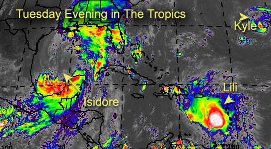
The energy... and core... sapped from Isidore... Will it be a hurricane once more?
Possibly. It has to regain an awful lot of momentum and showers around the core, and the main convection is away from it. The time over the Yucatan really killed the system.
Still TX/LA to AL/FL borders for landfall there, but I'm not expecting more than a cat 1 at the moment, although it could change... watch the system.
Lili is going to fight land a few times, and we may see it go in the Gulf or along the east coast. Apologies today, I've been away most of the time and have yet to go through all the data as of yet.
I hope for more tomorrow. Sorry for the short update today.
Cancun, Mexico Radar
NRL Monterey Marine Meteorology Division Forecast Track of Active Systems (Good Forecast Track Graphic and Satellite Photos)
NASA GHCC Interactive Satellite images at:
North Atlantic Visible (Daytime Only), Infrared, Water Vapor
Some forecast models:
NGM, AVN, MRF, ETA ECMWF
DoD Weather Models (NOGAPS, AVN, MRF)
AVN, ECMWF, GFDL, MM5, NOGAPS, UKMET
Multi-model plots from WREL
Other commentary at Mike Anderson's East Coast Tropical Weather Center, Robert Lightbown/Crown Weather Tropical Update Accuweather's Joe Bastardi, Hurricane City Weather Audio Broadcast Network - Live Audio from Jim Williams and Barometer Bob , mpittweather , Tropical Weather Watchers.Com (JasonM) Gary Gray's Millennium Weather, Barometer Bob's Hurricane Hollow, Snonut, Ed Dunham and Jason M in our Storm Forum Even more on the links page.
- [mac]
| Unregistered User |
| (Unregistered) |
| Wed Sep 25 2002 12:45 AM |
|
|
Will Izzy ever get its act together? He still has about 36 or 48 hours to organize itself. I dont know but i would like some other folks opinion please. I think the winds may get back upt o about 80 but maybe not anymore then that.
| Rick |
| (Weather Watcher) |
| Wed Sep 25 2002 12:51 AM |
|
|
Yup! That's what I said!
Now back to the irrelevance of the GFDL models...
Here's an exerpt from their homepage about "its flexibility"
"This infrastructure includes software to handle parallelization, input and output, data exchange between various model grids..."
I think their "parallelization" software is either spazzing, or is seriously flawed.
Those crazy ivy-leaguers probly drafted the met dept to be on their football teams! Don't be surprised if we start seeing X's and O's on the model output!
| Bruce |
| (Weather Guru) |
| Wed Sep 25 2002 12:52 AM |
|
|
I agree, Cat 1 at best, if that.
| Unregistered User |
| (Unregistered) |
| Wed Sep 25 2002 12:56 AM |
|
|
izzy will be like all the rest this year nothing but rain something this year wont let them do a lot up this way lions said he is as strong as he will get uper low wont let him grow up i say m/al line sun storm izzy just another dud
| Unregistered User |
| (Unregistered) |
| Wed Sep 25 2002 12:58 AM |
|
|
I want to know why this new thread still says a TX/LA landfall is still possible. There is no way it can come back to the west to do that.
| Unregistered User |
| (Unregistered) |
| Wed Sep 25 2002 12:58 AM |
|
|
no cat izzy making me dizzy must be a dog
| Unregistered User |
| (Unregistered) |
| Wed Sep 25 2002 01:01 AM |
|
|
Hopefully Izzy dont do an Opal on us 60mph now 12 hours later cat 3 heading for mobile
| Londovir |
| (Weather Guru) |
| Wed Sep 25 2002 01:05 AM |
|
|
I know all the models and such say Lili is heading towards Haiti/DR, but looking at the GOES IR loop for the western Atlantic, it looks so much like the convection of the storm is heading northwards towards Puerto Rico, the eastern side. Weather observations from the US Virgin Islands and N.A. are showing heavy gusty winds, almost at T.S. strength. Lili is pulling clouds into it from the south as well.
Or...I've stared at these loops of Izzy until he was giving me a tumor.
Jay
| Steve |
| (Senior Storm Chaser) |
| Wed Sep 25 2002 01:14 AM |

|
|
|
Yeah, isn't it though. That's the same thing I was saying. He's definitely one for the history books. I haven't looked at too much footage of Cuba and Mexico, but from the little I did see, some communities got hammered. There had/has to be some 40"+ spots and that just doesn't happen too often in the real world. It goes to show how strong and how much energy Isidore had, and really, how formidable it could have been for some of us. As it is now, they're up to Advisory #35 (winds now gusting 25-30 the last few minutes). So if he regenerates - as has been speculated all along - I think it's a storm name worth retiring.
Here are some of my reasons:
1) Confounded (mostly) models and forecasters.
2) Long tracked, SeptemberAfrican Wave system.
3) Various damage and disasters in many countries (Jamaica, Cuba, Mexico, etc.).
4) Reached strong Cat 3 status (had much higher potential).
5) Outer influence affected the entire I-10 Corridor east of Lake Charles 2-3 days before landfall.
6) 35 advisories - (possibly 45 by landfall or shortly thereafter).
It's also been a lot of fun to track for the last couple of weeks on the internet.
| ShawnS |
| (Storm Tracker) |
| Wed Sep 25 2002 01:19 AM |
|
|
What's the deal with the mention of TX/LA landfall still? No way this thing can come back west! I guess just covering the old backside there...hahaha!
| tom5r |
| (Weather Watcher) |
| Wed Sep 25 2002 01:21 AM |
|
|
Lili's definetly pulling clouds in from the south and is also starting to wrap around the west side and moving more to the northwest.
http://www.srh.noaa.gov/radar/loop/DS.p20-r/si.tjua.shtml
| Rick |
| (Weather Watcher) |
| Wed Sep 25 2002 01:24 AM |
|
|
"It's also been a lot of fun to track for the last couple of weeks on the internet."
I don't think I've seen one single complete acurate track or intensity forecast from anyone (including myself). This one definitely stymied everyone. But seeing how those better educated and more in the loop got it wrong too, I don't feel so bad!
crow on the house! Avila's buying!
| HanKFranK |
| (User) |
| Wed Sep 25 2002 01:26 AM |

|
|
|
think lili may have opened up, or had the center reform east again. theres no deep convection within about 100 miles of where the 8pm position was given. recon is down there now, we'll know pretty soon.
isidore is of course doing little if anything. some of the convection from the southern band group is closing on the se side of the center.. or at least suggesting it wants to. izzy really did an amazing job at wrecking itself over land.
im still getting flashbacks to fore caster matthew. maybe it's the unintelligible posts i keep seeing. then there are the allcaps ones, THE VOICE OF GOD. maybe the same person? well, they do have one thing in common.. neither ever has a clue. anybody else notice this?
HF 0128z25september
| Unregistered User |
| (Unregistered) |
| Wed Sep 25 2002 01:27 AM |
|
|
Londovir, Lili is still getting hammered by shear from the ULL to its SW and I've also had trouble figuring why the fix on the center was put where it was. Look at the latest IR loops and you will see the convection getting pulled in towards the center which is on the SW side of the convection. She is there and yes your eyes aren't deceiving you, the convection is getting torn northward. This will settle out towards morning and tomorrow we will see a more organized system. Latest GFDL has her going into the Yucatan at 120 (like they need it). Don't agree with that. Think it will go over Cuba and run up the Fl east or west coast. GOM possible, but I think it will run out of ridge. Izzy will still get cranked. Trust me. T'storms now coming in from the NE closer towards the center. I still say Cat 2, maybe 110 mph. Cheers!! Steve H.
| Unregistered User |
| (Unregistered) |
| Wed Sep 25 2002 01:30 AM |
|
|
This question was on the last board, so I thought I would repost and hopefully get an answer.
The same trough that is supposed to turn Isidore due north for the next two days is supposed to be so far south as to turn Lili shortly thereafter.
If this trough is going to be moving through and past Florida before Saturday, why wouldn't the trough push Isidore even further east?
I mean, is Isidore going to bust through the trough as it moves past her?
| Bruce |
| (Weather Guru) |
| Wed Sep 25 2002 01:32 AM |
|
|
If that is the center on the PR Long range loop it must be much farther north than 13.5N. And seems to be moving NW. I dont think the Radar would be picking up the center if it was at 13.5.
| Rick |
| (Weather Watcher) |
| Wed Sep 25 2002 01:33 AM |
|
|
I think we killed the GHCC site!
Either us... or CNN...FOX... and MSNBC
| Unregistered User |
| (Unregistered) |
| Wed Sep 25 2002 01:34 AM |
|
|
I still stick to my original landfall of Biloxi to Apalachicola. I think Apal. is out of the question, but Pensacola is not. The track will have to be shifted east in the next 12 hours. Just my humble, novice opinion.
| Rick |
| (Weather Watcher) |
| Wed Sep 25 2002 01:42 AM |
|
|
"If that is the center on the PR Long range loop it must be much farther north than 13.5N. And seems to be moving NW. I dont think the Radar would be picking up the center if it was at 13.5."
More like 16.5, I'd say!
| Unregistered User |
| (Unregistered) |
| Wed Sep 25 2002 01:43 AM |
|
|
Does anyone think Izzy could make it back to hurricane strength? It does seem to be a little better looking but not much? Where is Jason let me hear your opinion or anyone else.
| Unregistered User |
| (Unregistered) |
| Wed Sep 25 2002 01:43 AM |
|
|
NAAA aint gonna be much, just a big ole rainmaker , IZZY later, LA. prepare the boats and get your waders on . Izzy done commited suicide in mexico comin upo for some cajun food !! just enuff to quench her thirst Y'all be safe down there ya hear...... min trop storm 65kts
| Steve |
| (Senior Storm Chaser) |
| Wed Sep 25 2002 01:44 AM |
|
|
|
|
http://hurricane.accuweather.com/adcbin/hurricane/satellite.asp?ocean=atlantic&type=loop&sattype=ir&thisreg=gul
Accu's still up, but it's delayed. Still, think the center is moving maybe due north? One of 3 things - Sat repositioned; IR Trick or center getting back closer to 90? I hate not having access to live sat photos.
Steve
| wxman007 |
| (Meteorologist) |
| Wed Sep 25 2002 01:45 AM |
|
|
I think so...Izzy is moving slower and more easterly than forecast...and I think things are improving near the core...I'd say that Izzy should make it to Cat 1 status before landfall...
| Rasvar |
| (Weather Master) |
| Wed Sep 25 2002 01:45 AM |

|
|
|
Lili is hard to look at. I think she is still there somehow. Going to have to wait for recon. Gut still thinks a follow of Isidore to the west of Cuba is very likely if no northward motion begins soon. No idea on intensity, though.
With Izzy, I'm still sticking with my middle age fat man theory. Not much reason to change what I have bee thinking. Very slow strengthening up until landfall. I don't foresee any explosive growth. Cat 1 maybe marginal cat 2 if situation is perfect. Still think MS/AL border is most likely landfall point.
| Unregistered User |
| (Unregistered) |
| Wed Sep 25 2002 01:53 AM |
|
|
Thanks Jason, I agree maybe 80MPH or so. I aint even gonna pay attention to Steve Lyons. If this becomes a hurricane it will be my first yay haha.
| Londovir |
| (Weather Guru) |
| Wed Sep 25 2002 01:53 AM |
|
|
Lili sure is tough to spot right now. I can see the large storm cluster firing up to the SW of the larger cloud cover. It looks like overall Lili is tightening up. Looking at the IR you can see the storm clouds pulling inward on all sides on the IR, but I'm waiting to see the next advisory on her to see where they spot the center at. I'm still saying PR is gonna get a stronger whiff than everyone thought....though, like everyone else, the crow pies have been flying as fast as the upper level winds lately. I've got spare ice cream in the freezer just in case!
Jay
| Frank P |
| (Veteran Storm Chaser) |
| Wed Sep 25 2002 02:04 AM |
|
|
Three buoys report max wind gusts in the 40s... Lowest pressure 998....
for those interested - summary link provided for your reading pleasure
http://www.ems.psu.edu/wx/buoydata/t-01/gulfofmex.html
| Unregistered User |
| (Unregistered) |
| Wed Sep 25 2002 02:10 AM |
|
|
Frank what does this mean? Is Izzy ever gonna strengthen?or is it already starting to??
| Frank P |
| (Veteran Storm Chaser) |
| Wed Sep 25 2002 02:20 AM |
|
|
I can't access the GOES IR sat.... what's the deal with that... we are getting our second deluge in the past hour or so... about 2-3 inches tonight alone....
I was just watching the IR loop on TV.... I made a comment on the previous page that convection was building off to the NW and N of the system... this is continuing to develop....and is really trying to initiate that wrapping process to get back to the center..... IF this does occur within the next 12 hours or so, I think we'll see some strengthening... to what? Maybe strong Cat 1, weak Cat 2... heck if I know... but know this, if you start getting some decent convection wrap around this worn out old man, he just might get his second wind... he's not moving as fast as projected... so all bets are off if he can get it together in the next 12 hours or so...
I can't ever remember getting rain from a tropical system 450 miles from my house .... ever... THIS IS BIG BOY
| Unregistered User |
| (Unregistered) |
| Wed Sep 25 2002 02:24 AM |
|
|
I was looking at the shortwave ir an the ir an i think it may be trying to do as u say. i think it will do what storms have done this year is try to explode right offshore then come ashore as a intensifying storm. thats what i think anyone else have a thought?
| Unregistered User |
| (Unregistered) |
| Wed Sep 25 2002 02:33 AM |
|
|
and that of course..means that Izzy will build to a category 4-5....
I love the illustration of an old man...here we have a storm that fills up the whole gulf of mexico...has 450 miles to go or more....warm SST's...and nice LLC....and CDO slowly developing around it now...and everyone is doubting whether it will strengthen...
top that with 60 mph winds to generate the moisture from the gulf....
what?...you all think we need more than this...?????
NOT...
cat 4-5 landfall...Mobile...
i hate it when I'm right...(.hope all this hype don't come true)
| Unregistered User |
| (Unregistered) |
| Wed Sep 25 2002 02:39 AM |
|
|
For once that actually makes sense but i dont see a cat 4-5 i see maybe at most a weak cat 2.
| Frank P |
| (Veteran Storm Chaser) |
| Wed Sep 25 2002 02:41 AM |
|
|
Hey Cat 5 Rick, you're killing me over here...
Our pal Izzy is just a big fat flabby middle age storm going through that mid life crisis and wants one more fling .......
Now the question is, will he get in good enough shape to get there?
Izzy now at 23.5N and 89.7 west 987 mb 60 mph moving N at 10mph
| Unregistered User |
| (Unregistered) |
| Wed Sep 25 2002 02:45 AM |
|
|
If some storms can develop then he will make it.
| mbfly |
| (Weather Guru) |
| Wed Sep 25 2002 02:51 AM |
|
|
|
|
hmmmm. STILL at 60mph, STILL going north, STILL same pressure...... and no change in forcast or warnings in my (AND rickinmobile's !) neck of the woods.
I'm going to bed; catch y'all in the morning. 'nite !
| Frank P |
| (Veteran Storm Chaser) |
| Wed Sep 25 2002 02:58 AM |
|
|
nhc says minimal Cat 1 when it goes inland.... much to do about nothing.... still heading for New Orleans.... this might end up being a big rain maker.... time for me to go to bed as Izzy doesn't warrant and all night vigil....
| Londovir |
| (Weather Guru) |
| Wed Sep 25 2002 03:11 AM |
|
|
Not to jinx anyone by saying good things and having the Three Weird Sisters out in the waters defy me, but the NHC looks to be hinting now that all 3 storms may be on the verge of dying out.
They admit to the weakening nature right now of Lili. (Even go so far as to mention the near-Puerto Rico circulation feature some of us saw tonight). Say it's very ragged, has no closed circulation at present, and is under shear from the north.
Kyle is expected to build up to Cat 1 status, but they indicate a northwesterly shear building in the upper levels that will likely start weakening it, combined with a possible stalling in its westward movement.
Izzy isn't showing signs of building up an inner core yet, and the recon found the hardest winds almost 120 nmi away from the center. Add to that dry air coming in with a trough and it's possible that the rug is getting pulled out from under Izzy.
From a standpoint of people and property, we can keep our fingers crossed! :-)
Jay
| Unregistered User |
| (Unregistered) |
| Wed Sep 25 2002 03:45 AM |
|
|
you sure may be right....at least it doesn't appear, that with a 10 mph forward speed...that Izzy will build quick enough...only a day and a half. however, on the satellite infrared..it sure appears to me that convection has fired on the entire eastern side of the storm...and will soon envelop the entire LLC...we'll see...
still think a cat 1 is on the extreme low side..got a feeling it can fire up..especially since the weather center indicated once over the deeper waters..more energy could be tapped...
we will see..right?...see ya'll in the am...
be an interesting day tomorrow...for sure.
as for lilly...if it stays weak...shouldn't it also stay west?....hmmmmmmm
| HanKFranK |
| (User) |
| Wed Sep 25 2002 04:33 AM |
|
|
|
|
before i call it a night (no reason to stay up when satelite imagery doesnt update.. except for occasional goes-10 shots for gulf and w caribbean storms at nrl monterey).. going to make a couple more comments. lili appears to have opened up.. either going to reorganize in some new and different way, or just got its ticket punched and went to hurricane heaven. it is in the hurricane graveyard, after all. playing chicken with the shear monster too.. anybody notice how shear hasnt really relaxed at all with lili? fair to say that guidance is now completely useless with this storm.
isidore, in the most recent sat frames before overnight blackout.. has some convection on its SE inner bands. no, this isnt me jumping up and screaming 'i can see a spin cdo reforming' or 'definitely moving east'.. just observing that there are now more than low clouds on the S/SE quadrant of the storm. no hype baby, just the facts. izzy made its move offshore overnight during the satelite blackout, no reason to believe it wouldnt choose a similar time to start reconstructing its inner core...
im not sold, but finally see something as opposed to nothing.
kyle.. what about it? it has an eye, but is apparently a 55kt tropical storm. whatever. it isnt bothering anybody but a few jellyfish and herring, so why worry about such trivialties?
isidore may still be a benign tropical storm by daybreak tomorrow, but if i see a cdo in the morning then it's on again.
HF 0436z25september
| Unregistered User |
| (Unregistered) |
| Wed Sep 25 2002 06:14 AM |
|
|
who cares, Iz makes landfall as weak hurricane or strong TS<< way to much hype on this storm coming up into the gulf the last 2 days.,who cares,,it wont be much. Lily is a pussie and was never more then 50mph after barbados. Kyle is a fish storm,,,we have 2 weeks till teh sw carribean starts up. cant wait!!!!!!!!!!
| Unregistered User |
| (Unregistered) |
| Wed Sep 25 2002 06:17 AM |
|
|
go look on this site at monterey marine sat look big ball right by izzy center what do you see this looks good
| Frank P |
| (Veteran Storm Chaser) |
| Wed Sep 25 2002 06:28 AM |
|
|
yeah so what, I am addict to this crap.... IR loop on TV shows the deep convection building off to the SE that HF mentioned in his post.... might just be the start of a CDO trying to kick in... critical to continue if this thing is going to even make minimum hurricane... a couple of buoys north of the center wind gusting to 47 and 52k...
| Unregistered User |
| (Unregistered) |
| Wed Sep 25 2002 06:37 AM |
|
|
looks to trying to reform just to the east they said this could happen i wish the sat when get back around
| Unregistered User |
| (Unregistered) |
| Wed Sep 25 2002 10:41 AM |
|
|
Appears Florida is to be spared again as Izzy is dying and Lillie falling apart. This has been the strangest year I 've ever seen as only Izzie has even looked like a tropical storm on satellite pictures. The epithet at the end of the season will say "a busy hurricane season once again occured" but anyone who follows these "storms" will have a difficult time stomaching that description. It has been interesting though , and I've learned to not look at the models anymore as putting your finger in the air to feel the wind direction is a better predictive method. Dave in Stuart
| Steve |
| (Senior Storm Chaser) |
| Wed Sep 25 2002 10:49 AM |
|
|
|
|
Are anyway from 2-9" from south of Jackson all the way to the coast - FL, AL, GA, LA, MS. Definite rain event with Izzy. Look for some places to approach 20" before it's all over.
Steve
| ShawnS |
| (Storm Tracker) |
| Wed Sep 25 2002 10:55 AM |
|
|
How can you even find the center of Izzy anymore? I don't think the NHC even really knows where it's at. I just looked at the latest loop and I couldn't even begin to tell you. It looks like it could be east of where they are saying and yet at the same time it looked like it could be west. I guess you take the middle of the road and move on.
| ShawnS |
| (Storm Tracker) |
| Wed Sep 25 2002 11:04 AM |
|
|
What good are models if they always wait to the very last second to be able to finally get it right. I think more people on here had a better idea of where Izzy would end up than what the models did. It wasn't until right at the end when the models actually got it right, and by that time we already knew where Izzy was going anyway. Models have become a joke anymore. Let US do the official forecasting of these storms. Heck, I bet we'll have a better % than the models. Ha,Ha,Ha!
| Unregistered User |
| (Unregistered) |
| Wed Sep 25 2002 11:19 AM |
|
|
Yesterday, it looked like we would have 3 hurricanes today possibly threatening to come at the US from different directions. Today, we have 2 storms dying out and the 3rd will probably turn around and go out to sea. I guess someone finally found the dynogel supply again. LOL
| Rasvar |
| (Weather Master) |
| Wed Sep 25 2002 11:36 AM |
|
|
|
|
Talk about someone turning off the switch. Looks like we are going from turbo mode down to looking for a swirl in a cloud again. Izzy is pretty much toast, kyle a non-factor, Lili may have some life left; but unless some organization happens quickly, may be gone in hours. Crazy week and a half, just wasn't expecting such an abrut stop. Who broke the ride?!
| Unregistered User |
| (Unregistered) |
| Wed Sep 25 2002 11:36 AM |
|
|
I agree with everyone's assessment of the models...a joke, really...but gives everyone a job at the weather centers...and to cover themselves...when near land..these things get hyped.
izzy looks terrible..heavy cdo occuring on the east side..but dry air on the west...movement fast enough that there won't be time to regenerate....a ho hummer...
Lilly could stay south, however, and travel more due west. Not savvy enough to know what might happen with that, cause i don't bother reading the models...ha! I just watch the loops...listen to Bastardi, and then make my normal prediction of a category 10 hitting Mobile...no big whoop..
rain rain rain rain rain....
| Unregistered User |
| (Unregistered) |
| Wed Sep 25 2002 11:42 AM |
|
|
Welcome to Sunny Florida. The hurricane repellent is being sold at your near by 7-11. No hurricanes are allowed in the Peninsula since Floyd shut down Disney World for one day a few seasons back.
We had lots of rain here yesterday and its a kind of partial overcast day to day. I think we will be comparing inches of rain from place to place rather than tracking any significant storms.
Its fun to watch the weather channel figure out what to say now that the hurricane script doesn't fit. Finally, television entertainment at its best!
| ShawnS |
| (Storm Tracker) |
| Wed Sep 25 2002 11:46 AM |
|
|
Here's my theory... whatever the models say, go with the complete opposite. This means we still have not had a landfalling hurricane this year in the U.S. I don't think we will. We did have some T.S. landfalls, but nothing major. That's Good!
| Unregistered User |
| (Unregistered) |
| Wed Sep 25 2002 11:48 AM |
|
|
I have to agree the models are a joke. They still show the path west of 90 degrees. Izzy hasn't been past 90 yet and I don't think there's a snowball's chance in hell it goes past now. Still think the actual landfall is on the eastern side of the NHC projected path.
| Rick |
| (Weather Watcher) |
| Wed Sep 25 2002 11:55 AM |
|
|
The models are only as good as the data they are fed. (the garbage-in, garbage-out theory)
I'm only guessing when I say; the difference between the models is the emphasis they put on different contributing factors. Some have a better history of accuracy early in the season, some later. I think the only real time I put any faith in them is when they start to have a consensus.
| ShawnS |
| (Storm Tracker) |
| Wed Sep 25 2002 12:02 PM |
|
|
That's true, but by that time we already know where it is going so what do we need them for?!?!?! Like FLREBEL said, some are STILL saying west of 90 and we all know that is not going to happen. I say just let the humans take control and let's not depend on the computers on these systems anymore. As we have seen, we can't do any worse than what the models have been doing.
| Steve |
| (Senior Storm Chaser) |
| Wed Sep 25 2002 12:06 PM |
|
|
|
|
Okay, so yeah - they suck. But do they all, all the time? No way. European (ECMWF) has been predicting landfall in SE/SC LA for a week. NOGAPS has been on it since Friday at 12Z. Timing was off, but they caught the landfall assuming it does hit LA.
How bout it for the N or NNW movement that's been showing up the last few days? Everyone here - including the paid experts - figured on a landfall NE of the tracks. When it came down to it, the models eventually beat everyone but Frank P.
http://www.esl.lsu.edu/special_gifs/Gulf.gif
That's a decent IR shot from LSU that shows the center apparently riding up 90.
Steve
| meto |
| (Weather Guru) |
| Wed Sep 25 2002 12:11 PM |
|
|
its not near 90 .longitude
| Rick |
| (Weather Watcher) |
| Wed Sep 25 2002 12:14 PM |
|
|
Yeah, I see your point. But if the modeling was that good, we wouldn't need the experts. (experts-->
BTW...06GFDL on Lili still shows her strengthening to a cat1 hit on the same spot in Cuba that Izzy deluged! Anyone believe that?
| Steve |
| (Senior Storm Chaser) |
| Wed Sep 25 2002 12:23 PM |
|
|
|
|
So exactly where is the center if its' not near 90? 75West? Sour grapes?
Steve
| Steve |
| (Senior Storm Chaser) |
| Wed Sep 25 2002 12:25 PM |
|
|
|
|
AT 7 AM CDT...1200Z...THE CENTER OF TROPICAL STORM ISIDORE WAS
LOCATED NEAR LATITUDE 25.5 NORTH...LONGITUDE 90.0 WEST OR ABOUT 305
MILES SOUTH OF NEW ORLEANS LOUISIANA.
?????
| Unregistered User |
| (Unregistered) |
| Wed Sep 25 2002 12:33 PM |
|
|
If it's not near 90, where is it then. I guess the NOAA recon has no idea what they are talking about. You haven't been close with anything you've posted. Run along and play little boy.
| Unregistered User |
| (Unregistered) |
| Wed Sep 25 2002 12:43 PM |
|
|
they show the center at 90...and yeah, maybe...but somehow I think it is close to the edge of the east side bands...
here's a thought....not much movement today....and the thing get's it act together....whatchyall think?
wonder why Neil Frank thought it'd be a 3...
gotta go to work..later
| Rick |
| (Weather Watcher) |
| Wed Sep 25 2002 12:44 PM |
|
|
"Okay, so yeah - they suck. But do they all, all the time? No way. European (ECMWF) has been predicting landfall in SE/SC LA for a week. NOGAPS has been on it since Friday at 12Z. Timing was off, but they caught the landfall assuming it does hit LA."
So... what would be the best way to rate the models as to efficiency? Landfall position,intensity, and timing? Distance from plotted course... deviation from forecast strength? Any thoughts?
| Frank P |
| (Veteran Storm Chaser) |
| Wed Sep 25 2002 01:32 PM |
|
|
Quite evident where the center of this thing is .... 25.77N and 90.06W
and yes it has cross 90W degrees in my opinion....
I predicted New Orleans three days ago when Izzy was drifting south on the YP, also said it would go north when is was basically stationary onland. Initally stated it would hit Pensacola last Thursday prior to the big diversion off to the west last weekend... Miss on intensity as I really though he had a chance to get to a Cat 2, probably lost any chance of that with the increased forward speed at 13.... win some lose some... had to eat a little crow with the first prediction but the second one looking pretty solid right now... and we on the MS coast should get some winds in the 40-50 mph range with tides approaching 4 feet above normal... no big deal... just worry about tornadoes some.... and rain for the flood prone areas of the coast....
did notice some convection developing just east of the center, not much still something to watch as Izzy roars towards SE LA
| Steve |
| (Senior Storm Chaser) |
| Wed Sep 25 2002 01:38 PM |
|
|
|
|
Tools (in more ways than one). But check this out. I came to work at the Bank this morning and there's a freaking roof leak in my office with powdered tiles all over my equipment! BAH!
Steve
| joepub1 |
| (Storm Tracker) |
| Wed Sep 25 2002 01:48 PM |
|
|
90.06W? What? Not going past 90W was the only thing I had gotten right! Now your going to say he's at 90.06? Man.... this is not fair....
| Rick |
| (Weather Watcher) |
| Wed Sep 25 2002 01:48 PM |
|
|
It's a diversion! Quick! Check the vault!!!
| Unregistered User |
| (Unregistered) |
| Wed Sep 25 2002 02:06 PM |
|
|
Ha HA ,
sounds like a very secure bank.
| Unregistered User |
| (Unregistered) |
| Wed Sep 25 2002 02:29 PM |
|
|
On the first Goes 8 visible of the day, I zoomed in and got the center at 25.95 and 90.23.
Steve
| Unregistered User |
| (Unregistered) |
| Wed Sep 25 2002 02:31 PM |
|
|
My office is at the interesection of 2 buildings, so there must be a crack.
Steve
| Unregistered User |
| (Unregistered) |
| Wed Sep 25 2002 02:46 PM |
|
|
Also finally looks to be wrapping a little convection nearer to the center. Convection is getting much closer on the NW, N, NE, and E side. Just a little while longer, and Izzy will strengthen though not to the level I once thought, will still be a hurricane at landfall. 80-90mph.
| Unregistered User |
| (Unregistered) |
| Wed Sep 25 2002 02:48 PM |
|
|
Can someone explain to me what a baroclinic system is exactly and explain why Isidore is not being listed as one.
Thank YOU
| Frank P |
| (Veteran Storm Chaser) |
| Wed Sep 25 2002 02:56 PM |
|
|
Izzy right now is looking about as good as it has since leaving the YP... Still on track to go inland in SE LA west of NO and then just west of Lake Pontchartrain.... still lacking a cdo... and struggling to get one... but...
I still think it has a shot at getting to min Cat 1 prior to landfall... should get to 65 mph winds at 27N and then reach min hurricane status at around 28N... best guess....
| Unregistered User |
| (Unregistered) |
| Wed Sep 25 2002 03:05 PM |
|
|
90.2 is the official position, and 355 is the official track. That puts the city with a better chance to be on the eastern side of the storm and hence, more rainfall. It's pouring right now, but we still don't have tropical storm conditions - just gusting in the low 20's. It also means that MS and AL should have the bulk of the feed and run the highest damage for localized flooding.
Steve
| HanKFranK |
| (User) |
| Wed Sep 25 2002 03:09 PM |
|
|
|
|
izzy moving north, not changing. remains the possiblity of a threat.. but set to be a rainmaker/day off from school or work. maybe will hit near houma.. be nice to get something right. lili slowed down but sheared and disorganized.. maybe open. hurricane graveyard, go figure. if it doesnt find some way to die, could become a lingering threat for early next week. kyle wandering around, perhaps for a while, perhaps to die as globals suggest, in a few days.
another year of bountiful but underachieving tropical cyclones, so far. the 3 season no u.s. hurricane streak only has 3 more weeks to go. come october 15-16, three years after irene crossed south florida.. it's made.
HF 1510z25september
| joepub1 |
| (Storm Tracker) |
| Wed Sep 25 2002 03:10 PM |
|
|
Just a quick look at what's happening.
Izzy looks more sup-tropical then anything else. Looks like he'll stay a little wind, some waves, but the 'tail' he's dragging along to SE,E,NE will end up the story as far as the US goes.
Up to landfall, and a day or so afterwards, from MS east should get a pretty steady diet of rain,rain,rain. We set a record here in Jax with 4.5 in. yesterday, much drier today up to this point. I think we still got one more good soaking to come before he goes to hurricane heaven.
Lili, IMHO, remains to large to write off as a wave. If that's a trop. wave, it's a big one. The models, for what their worth, really slow her down in a day or so. Even if the NHC drops her as a TS, you might want to keep an eye on her coming back, poss. in the lower GOM. or Bahama's.
Kyle is out there, going nowhere very slowly.
Joe in Jax
| Unregistered User |
| (Unregistered) |
| Wed Sep 25 2002 03:12 PM |
|
|
Hmmmmm..... Does anybody notice the striking similarities between Izzy and Lili? Both were supposed to become Hurricanes in the eastern Carrib. and move NW. Now, just like Izzy, an ULL just to the west of Lili has weakened her and she is staying on a more westerly course. Looks like she may even open up to a wave ala Izzy. I look for regeneration near Jamaica again. Then things could get interestin. This time for FL west coast. Just a hunch, but keep an eye out.
| Frank P |
| (Veteran Storm Chaser) |
| Wed Sep 25 2002 03:52 PM |
|
|
Last vis pic shows the center of Izzy at 26.2N and 90.5W.... took a little more jog to the NW....
| cappycat |
| (Verified CFHC User) |
| Wed Sep 25 2002 03:55 PM |
|
|
We have battened down the hatches, but not overly worried about izzy. We boarded up, got our bottled water, but planon staying inour house. We are expecting some rain (lots) and some wind (not so much). Right now, the wind is really gusting and the rain is sporadic, occassionally heavy, as the bands pass over. Most of Raceland lost electricity last night for a little bit. Not sure if it was directly or indirectly related to the storm.
Folks east of us are gonna get some serious rain out of this. Be safe, folks.
| clyde w. |
| (Storm Tracker) |
| Wed Sep 25 2002 04:51 PM |
|
|
That's my moniker for our triplets.
Lilli's looking a little better on the visible loops this a.m. There is a hint of an LLC on the western edge of the convection. She might just hang on to be trouble later this week. Waiting to see what recon finds today.
Looks like Isisdore will go inland at 60mph and be yet another underachieving rainmaker. Some higer power must really like us...I *think* that the U.S. has never gone 3 consecutive seasons without a hurricane strike.
Kyle is one of the best looking non-hurricanes I've seen in a while. It's amazing to me that we can have a 110mph Isidore off of Cuba with no eye, and a 70mph Kyle with a perfect eye in the Central Atlantic. Will wonders never cease.
| Rasvar |
| (Weather Master) |
| Wed Sep 25 2002 06:21 PM |
|
|
|
|
Well, seems that Lili is playing the reforming center game. Going to be interesting to watch over the next few days. I was about ready to write her off; but she seems determined to come around. Gut feeling is still Western Carib near where Izzy was; but, the chance of being cuaght up and sent north still seems to be there. Lily may surprise us in the next few days.
| Kevin |
| (Weather Master) |
| Wed Sep 25 2002 06:37 PM |

|
|
|
Isidore: Really doesn't look too tropical at this point...naked on west side with nearly 100% of the convection to the east of the center. Indeed, Isidore is very broad. He won't become a hurricane again because there is just too much to pull together...a strong tropical storm (60-70 MPh) and should spawn some tornadoes and dump tons of rain. Could have been a lot worse than this.
Lili is playing a game with us...she looks good when recon gets in but slack off after they leave. All kidding aside, I believe she may finally start to intensify. I'm shifting further west now, perhaps just south of eastern Cuba by Friday (she's moving at 8 knots!) With this movement, the trough may well bypass Lili and she will travel slowly towards the western Caribbean...and we could have another major storm. Even the models that recurve her are shifting the recurvature further west...could be in response the her slow movement. A threat to Florida still exists, but it is now delayed. We should have nice weekend but we will need to keep our eyes on Lili. Once again, thinking threat to WC of Florida increases if Lili isn't a hurricane by Friday or early Saturday at the latest.
From what I heard, Kyle's eye looked great this morning. From what I see now, however, he is starting to look a little distorted overall. He's very small, and a lot can happen to small storms.
Kevin
| Bruce |
| (Weather Guru) |
| Wed Sep 25 2002 06:55 PM |
|
|
Thats right clyde, 3 years, no land falling Hurricanes in the US. But, the season is not over just yet.
| Unregistered User |
| (Unregistered) |
| Wed Sep 25 2002 08:13 PM |
|
|
I can't detect a motion.
| mbfly |
| (Weather Guru) |
| Wed Sep 25 2002 08:17 PM |
|
|
|
|
Here in Rickinmobile's neighborhood, the sky is brightening, light breeze, no rain and hummingbirds at my window feeder. Maybe Izzy is GONE............ right ????
| Unregistered User |
| (Unregistered) |
| Wed Sep 25 2002 08:36 PM |
|
|
Izzy is looking a little better this afternoon--big blob of convection has developed just north of the center, and the latest recon reported 67 knots at flight level --still seems to be moving mostly north, but a little bit slower. will be interesting to see if nhc increase the winds a bit on the next advisory
| Unregistered User |
| (Unregistered) |
| Wed Sep 25 2002 08:41 PM |
|
|
Frank, I agree when u said that izzy may make it to hurricane strength. doesnt interaction with land or the friction cause a storm to intensify right before it moves ashore? I dont know but im just asking. Storms around here in pensacola this yeah have done that they are weak an look like crap away from land but when the center is about 50 100 miles away from landfall the storm intesifys pretty rapidly. What do u all think
| Steve |
| (Senior Storm Chaser) |
| Wed Sep 25 2002 08:57 PM |
|
|
|
|
WOW! What a bitch trying to get to Old Metairie from downtown. Almost every major artery had some type of street flooding. I had to take several turns to get home - including crossing several inches of rain in many locations. French Quarter was flooded in spots, CBD, Metairie - we're under a Flash Flood Warning right now in Jefferson Parish with another band building up overhead. First thing I did after I took off my sopping wet clothes? Opened up an Abita Amber. This Abtia's for all you guys!
Steve
| Frank P |
| (Veteran Storm Chaser) |
| Wed Sep 25 2002 09:10 PM |
|
|
<<<<I still think it has a shot at getting to min Cat 1 prior to landfall... should get to 65 mph winds at 27N and then reach min hurricane status at around 28N... best guess....>>>>
Posted this on the board at 10:30 this morning....... Izzy is now at 65 mph at 26.8N.... missed it by .2 degrees... don't you just hate a smart ass .... hehe
rolling with this one..... Now will it get to 75 mph by 28N? Looks likes he's trying to tighten up somewhat and I'm not sure he is moving as fast as the nhc indicates.... sure would like to be 2 for 2....
gotta go put up some plywood.... just in case...
| Unregistered User |
| (Unregistered) |
| Wed Sep 25 2002 10:31 PM |
|
|
lions said last few frames look to be ne we will see do you see this anyone