CFHC
|
| () |
| Fri Sep 27 2002 04:59 AM |

|
|
|
What an amazing track Isidore was.... first getting a run in with South America it pulled north a bit to enter the Western Caribbean. Was it planned to be a problem for Jamaica or Cuba at the time? No, but it flooded Jamaica and grazed the western part of Cuba. Now it was to move west... right?
Projections had it to go west then loop in the gulf and head north, rightly so many along the Gulf coast started to watch Isidore like a hawk. A few models hinted at a southerly jog first, but not into the Yucatan. Category 3 almost a 4, oops Isidore slides south into the hurricane warning area causing much pain to the North Yucatan coastline in Mexico. This rather impressive storm collapsed over the Yucatan, but it was so big the energy was disbursed, after it eventually moved back over the water it was unable to do anything more than hold its own... almost in a way that parts of the system were non tropical and others were.... Causing rain even to Florida it dumped copious amounts of rain along the coast and caused a minor storm surge in the New Orleans area...
To those who think Isidore was a bust, be glad, the alternative of a category 3 or 4 hitting New Orleans is not pretty. Much like Hurricane Bret a few years ago hitting in an unpopulated area in Texas, this one managed to avert a real catastrophe. Our intent here is not to want storms like this to hit, but to provide information to help determine what is going on. The interest level is higher amongst people when a major is in the Gulf, the numbers prove it, for reason... It could affect many people. The entire time I wanted it to fall apart and was looking for ways for it to happen. The Yucatan landfall wasn't it for me. Mexico sure did not need it. The rather light hit on New Orleans may be a slight wakeup call for them, though, and if that's the case then that would be the good side to it.
Lili will follow fairly closely Isidore's previous path near Jamaica and Cuba, and after that I'm not able to say yet, but of course again we must all watch it. There are Tropical Storm watches up now for Jamaica.
Kyle is backing down fairly far south and believe it or not we still may have to watch this one along the Eastern Seaboard. Models differ some one to loop it around and back northeast, others like the AVN pull it southeast even more.
NRL Monterey Marine Meteorology Division Forecast Track of Active Systems (Good Forecast Track Graphic and Satellite Photos)
NASA GHCC Interactive Satellite images at:
North Atlantic Visible (Daytime Only), Infrared, Water Vapor
Some forecast models:
NGM, AVN, MRF, ETA ECMWF
DoD Weather Models (NOGAPS, AVN, MRF)
AVN, ECMWF, GFDL, MM5, NOGAPS, UKMET
Multi-model plots from WREL
Other commentary at Mike Anderson's East Coast Tropical Weather Center, Robert Lightbown/Crown Weather Tropical Update Accuweather's Joe Bastardi, Hurricane City Weather Audio Broadcast Network - Live Audio from Jim Williams and Barometer Bob , mpittweather , Tropical Weather Watchers.Com (JasonM) Gary Gray's Millennium Weather, Barometer Bob's Hurricane Hollow, Snonut, Ed Dunham and Jason M in our Storm Forum Even more on the links page.
- [mac]
| WXMAN RICHIE |
| (Weather Master) |
| Fri Sep 27 2002 05:22 AM |

|
|
|
The tropics are coming back today. Lili has reformed and Kyle is down to 27 N. Lili will start to follow Izzy's track toward Jamaica and Cuba, but surely won't do a loop over the Yucatan after that. Kyle keeps losing latitude which makes it more and more likely it may bother the east coast later on. Izzy's worst outcome is that it causes sooo much rain in Louisville that the Seminoles lose.
| Rasvar |
| (Weather Master) |
| Fri Sep 27 2002 06:49 AM |

|
|
|
o/~Lili, Lili, Lili, get your adverbs here o/~ opps, wait that was lolly. Either way, I suspects lots of adverbs and adjectives will be used over the next week as Lili acts like Izzy's twin. Probably quite a few four letter words. Another system with a lot of destructive potential in the future.
| Unregistered User |
| (Unregistered) |
| Fri Sep 27 2002 08:02 AM |
|
|
Bastardi seems to thing we will have another major hurricane in the gulf in a few days. All I can say is....oh boy.
| Unregistered User |
| (Unregistered) |
| Fri Sep 27 2002 08:13 AM |
|
|
00Z globals have all changed their tune. I had her pegged as an eastern Gulf storm on Tues. or Wed. but it may well be a Central/Western Gulf storm. It appears that a blocking high will be in place when Lili is at 85W with another building in from the W (models are predicting trof between the two to be fairly weak). I like my seasonal Mississippi idea, but I think Lili is 150 miles east or west of Isidore's landfall in Lafourche Parish. This means a) A landfall in SW LA or N TX or b) a hit from Pascagoula to Panama City. Seasonally, this should be another LA/MS boder storm because that's where all of them have come in.
I'm going with a Waveland/Henderson Point, MS landfall and effects from Houma (pron. HO-ma) to Destin. In this scenario, beach erosion should continue along the FL and AL shores - not something you guys are anxiously awaiting.
Steve
| Unregistered User |
| (Unregistered) |
| Fri Sep 27 2002 08:30 AM |
|
|
For the record...
NWS stated today in the paper that Izzy had an 8 foot tidal surge...they had predicted only about 4-6 feet prior to the arrival of the storm...
I estimated in my post at the high of the storm at least 8 feet and maybe 9... at my house it was closer to 9 feet...
This gives Izzy a STRONG Cat 2 storm surge for the MS coast
Cat 1 - 4-5 ft
Cat 2 - 6-8 ft
Cat 3 - 9-12 ft
Cat 4 - 13-17 ft
Cat 5 - 18+
Lessons learned.... a large wind field associated even with a system less than hurricane force winds can generate larger than expected tidal surges...
Frank P
(Mike for some reason I was unable to log on)
| Rasvar |
| (Weather Master) |
| Fri Sep 27 2002 09:29 AM |
|
|
|
|
I won't make any predictions. I won't trust any model. Only thing I have to say is that the GFDL is saying Texas, therfore: look out Eastern Gulf!
| Mike |
| (Weather Watcher) |
| Fri Sep 27 2002 09:43 AM |
|
|
Here is the Vortex message for Lili, at least they could send one this time....
000
URNT12 KNHC 271215
VORTEX DATA MESSAGE
A. 27/1215Z
B. 16 DEG 06 MIN N
74 DEG 33 MIN W
C. NA
D. 40 KT
E. 017 DEG 38 NM
F. 090 DEG 041 KT
G. 024 DEG 44 NM
H. EXTRAP 1003 MB
I. 24 C/ 316 M
J. 26 C/ 312 M
K. 24 C/ NA
L. NA
M. NA
N. 12345/01
O. .1 /2 NM
P. AF985 0913A LILI OB 12
MAX FL WIND 41 KT NE QUAD 1134Z. SLP EXTRAP FROM 1500FT.
With estiminated surface winds at 40K, I am curious when they will upgrade it. Max flight level winds were only 41K.
| Unregistered User |
| (Unregistered) |
| Fri Sep 27 2002 11:03 AM |
|
|
As of 11am---what I wonder is on the recon it said CP is 1003...advisory says 1005...fluctuations already? Note, located further east, not good for Fl and Gulf....
IHS,
Bill
| Rasvar |
| (Weather Master) |
| Fri Sep 27 2002 11:08 AM |
|
|
|
|
While everyone watches Lili, I have a feeling in my gut that when everything is said and done, Kyle might be knocking at the backdoor and trying to sneak into Florida by the end of next week.
|
MikeC
|
| (Admin) |
| Fri Sep 27 2002 02:35 PM |
|
|
Just a note about the flhurricane downtime today. Flhurricane was down from 11AM to 2:30 PM after a hardware misconfiguration. Thanks to Brian Lawson up in Virginia for helping me fix the problem, and we're back up and running.
| Hurric |
| (Weather Guru) |
| Fri Sep 27 2002 02:37 PM |

|
|
|
CNN reporting up to 800 missing and dead in ferry boat capsizing in a "Fierce Storm" off the coast of Senagal.
Here is a link to the wave that emerged from the African coast and probably caused this tragedy
http://www.ssd.noaa.gov/PS/TROP/DATA/RT/eatl-ir4-loop.html
| Mike |
| (Weather Watcher) |
| Fri Sep 27 2002 02:52 PM |
|
|
Great work guys. I was starting to have FLHURRICANE.COM withdrawls
| Kevin |
| (Weather Master) |
| Fri Sep 27 2002 03:48 PM |

|
|
|
I'll start this post by saying this: with the current pattern in place, I am fairly confident that Kyle, Lili, or both storms could make landfall in the US. If we only have one landfall, one will mimic what the other does. Or, we could have seperate influences on the systems and they both come towards a US locations.
Kyle: Still holding his own. Quite a tenacious storm, but I can see some dry air starting to push on the north side of the storm. He should be weakened for the next 48 hours but intensify after that. The storm should meander W and SW through 72 hours. After that, the steering patterns will be more defined, one way or the other.
Lili: She's looking just as good as she did previously and the pressures are actually falling. The center relocation (easterly) along with the NW movement may not be good for the eastern GOM in the long-term.
Best bet at this point is that the storms play "copycat". No definite forecast at this point.
Kevin
| Unregistered User |
| (Unregistered) |
| Fri Sep 27 2002 04:41 PM |
|
|
Only 13 comments when there are 2 storms with definite US landfall possibilities. What has happened to this board. I think Lili has an even better chance than Izzyto mpact the US with major force. I do believe she will enter the Gulf, but I thuink she will go a little further east this time. After reading Joe B this morning, i believe that even though she will probably cross a lareger portion of Cuba than Izzy, she will not be a strong whenshe does so. Therefor, she should be in better shape to regenerate after exiting the coast. I will not make a prediction as of yet, but will amke the same old statment........ Everyone along the Gulf coast should closely monitor the progress of what will become Major Hurricane(Weak cat 3) Lili.
| Skeeter |
| (Registered User) |
| Fri Sep 27 2002 04:48 PM |
|
|
I think everybody is a little worn out after last week. It will be interesting to see how Lil does in the next 24-36 hrs. I am thinking east central Cuba, skirts EC Florida and Landfall around AppyLachyCola. There......On record for now, gotta go back to work........everyone have a great weekend.
Skeeter
| tom5r |
| (Weather Watcher) |
| Fri Sep 27 2002 04:49 PM |
| Attachment |
|
|
Looks like Lili is getting her act together. Poor Jamaica. Seems they're gonna get another soaking.
| LoisCane |
| (Veteran Storm Chaser) |
| Fri Sep 27 2002 05:17 PM |

|
|
|
Id think that the lower keys will get a soaking from Lili, thinking that more and more
| tom5r |
| (Weather Watcher) |
| Fri Sep 27 2002 05:25 PM |
|
|
yes loiscane, I've been thinking the same thing but, thats what I thought with Izzy too. We'll just have to wait and see.
| Unregistered User |
| (Unregistered) |
| Fri Sep 27 2002 06:52 PM |
|
|
Oh dear, I dont think I can handle another storm. Hannah and Izzy was enough. I do think if another storm comes toward Mobile, we will have lots of destruction, trees falling due to sogging ground, etc.
I pray Lili dies.......
| joepub1 |
| (Storm Tracker) |
| Fri Sep 27 2002 08:29 PM |
|
|
Evening to everybody.
As the GOM trys to return to a more normal state of affairs, Lili seems to be pulling herself together. She is trying to get her center stacked, and now that the center has found it's way under the convection, pressure is down to 999MB, droping about 1 an hour. Outflow is begining to look MUCH better; for a little while I thought the convection was begining to fade, now I'm thinking she actually at the begining of the spin cycle. Moving NNW, center jumping around a little bit, lower western Cuba seems a probable target, at least short term. Still very unlikely she'll cross Cuba anytime soon, I don't think South Fla stands a chance of seeing her. The Keys, maybe, but I haven't seen anything to make me look there,either. Models, in the long term, are already begining to do the Izzy dance, but are slowly shifting toward the east down the road, at least for the moment.
Joe in Jax
| Kevin |
| (Weather Master) |
| Fri Sep 27 2002 08:30 PM |
|
|
|
|
Now moving NNW at 7 MPh, motion expected to continue for next 24 hours.
A 5mb pressure drop...1004 at 5 PM compared to 999 now.
Winds are 45 knots, slow intensification expected for next 24 hours.
It will be interesting to see the changes (if any) to the forecast at 11:00 PM.
Kevin
| Justin in Miami |
| (Storm Tracker) |
| Fri Sep 27 2002 08:41 PM |
|
|
Well here we go again! I imagine this site will start to pick up in about 2 days or so. FYI.....The local TV stations in Miami have all but written Lilli and Kyle off. Calling for a couple of *passing* showers next monday as Lilli passes to the south.
| Unregistered User |
| (Unregistered) |
| Fri Sep 27 2002 08:52 PM |
|
|
The more northern postion is a concern but not to much. The GFDL model pulls Lili n-nw towards Cuba over the next 12 hours and then turns w-nw so lets see how long she moves nnw. If Lili moves north of Cuba then I'll be a bit more concerned but right now I still see a north central Gulf coast problem long term not south Florida.
| Unregistered User |
| (Unregistered) |
| Fri Sep 27 2002 09:26 PM |
|
|
Geez not lilly to i got back from the beach an it was pretty bad. There was debris everywhere an the roads an homes were still flooded. I dont think we can take another on especially the beaches.
| Unregistered User |
| (Unregistered) |
| Fri Sep 27 2002 09:48 PM |
|
|
Get yourself ready my friend , double trouble headin your way
| Unregistered User |
| (Unregistered) |
| Fri Sep 27 2002 09:52 PM |
|
|
| Unregistered User |
| (Unregistered) |
| Fri Sep 27 2002 09:56 PM |
|
|
this is nuts 1 time a week the last 4 storms now one more mobile must have good hurr soup
| HanKFranK |
| (User) |
| Fri Sep 27 2002 10:19 PM |

|
|
|
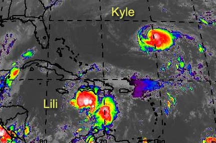
kyle's getting a good beating now.. no more eye, center is vertically disjoined. not moving much.. dependent on how much is left it will either get dragged out in an amplification.. or more likely just rebuild once the shear subsides, under the ridging to the north.
lili has gained some latitude.. maybe kyle is weakening the deep easterly flow and the ridging has turned her up a bit. could turn south of or north of cuba.. if it turns over cuba it wont do much intensification. fairly reliable modeling puts it into the upper yucatan peninsula or the channel.. isnt responding to steering the way models have been predicting, though. probably eventually will get into the gulf, but in what state is hard to say.
none of the other basin features merit much comment.. two late season waves somewhat feisty but not going to do much development next 48hr.
HF 0220z28september
| tom5r |
| (Weather Watcher) |
| Fri Sep 27 2002 10:42 PM |
|
|
TWC just said they expect Lili to stay on the n/nw course for several days. I wonder if they know something we dont. If thats the case, I see it going through the keys and into the gulf. Could this be?
| joepub1 |
| (Storm Tracker) |
| Fri Sep 27 2002 11:37 PM |
|
|
>TWC just said they expect Lili to stay on the n/nw course for several days. I wonder if they know something we dont. If thats the case, I see it going through the keys and into the gulf. Could this be? <
I wouldn't be sure who knows what. Let me quote the 11 pm disscussion:
I DON'T QUITE UNDERSTANDTHE MECHANISM FOR THIS NORTHWARD MOTION...BUT SINCE THE INITIAL MOTION APPEARS TO ALREADY BE DOING SO...
Sometimes I can't believe some of this stuff. If anybody does understand, please call the NHC and tell them. I think the forecast models just perform badly in this area of the world, as far as hurricanes go, and their forecasting relies way to much on them. Are we no better off than we were 50 years ago?
Lili, for whatever reason that the NHC "doesn't understand", is moving NNW. It is still forecast to turn more to NW-WNW during the day(or evening) tomorrow. It appears that it will ride the coast of Cuba(which coast I'm not sure now) toward an entry into the GOM. This should keep Lili from not getting above Cat1 for awhile, if she even reachs that point. Western Cuba is far from flat; if she finds herself stuck over land to long she may well be tore apart again. If none of the above happens, it will be for reasons I don't understand.
Kyle is going through a tough time right now. Best bet is keep an eye on him, but don't break a sweat yet. Still talking days before anybody can be sure what will happen with him.
Goodnight and sleep tight.
Joe in Jax
| Unregistered User |
| (Unregistered) |
| Fri Sep 27 2002 11:48 PM |
|
|
Latest GFDL run heads Lili towards the mouth of the river .... Wonder how many other different areas the GFDL will forecast in the coming days.... someone ought to keep count...
I also think system has a real good chance of being a GOM storm... just took down my plywood... this does not bode well for the MS coast because if I would have left it up, Lili would not have even thought about coming to this area...
Frank P
| Rasvar |
| (Weather Master) |
| Fri Sep 27 2002 11:52 PM |
|
|
|
|
Maybe Bastardi was right a couple of days ago and Lili will go meander in a small box near South Florida for a few days until the steering currents get reestablished.
| Kevin |
| (Weather Master) |
| Fri Sep 27 2002 11:55 PM |
|
|
|
|
Late night tropics:
Lili: She's moving NNW still, NHC isn't sure why, wait to see what the morning brings
Kyle: He's getting sheared quite badly, but he should make a comeback in a couple of days. Latest NHC forecast shows some westward acceleration by 72 hours. Could be a Florida threat...and a big one at that with high building in...but my confidence is very low at this point.
Here's to a good night's sleep.
Kevin
| Unregistered User |
| (Unregistered) |
| Sat Sep 28 2002 02:22 AM |
|
|
Well, i'm in Cancun, our brother city of Merida hasn't recovered yet from Isidore, the area has a lot of damages, but Cancun was missed by one hundred milles, I think we can not take one more hurricane, so, if you don't mind we rather let you take Lili this time my dear Floridian's.
But it seems that Lili is taking the same curse that Isidore took, hummm, as you can see there are many mexican's like me who have insomnia.
Everybody in Cancun are sending water and food to the victims of Isidore, and desperely looking for the info about Lili, but the info is always very confusing.
Greetings
Okane
| HanKFranK |
| (User) |
| Sat Sep 28 2002 02:56 AM |
|
|
|
|
well okane, one positive. the longer it keeps the northerly course, the less likely it will ever bother you. should it get north of cuba you're probably out of harm's way. news i've seen on isidore says that only two people perished in the storm.. your government must be very good about warning its citizens. and by the way, estoy deseando que mi espa�ol estar� tan bueno como tu ingles. probably botched the grammar.. heh. i'm learning.
some of the 00z model runs are out.. avn takes lili across the keys and south of the panhandle by 120hr. cmc still takes it to the yucatan. nogaps and ukmet arent done.. gfdl is still near cuba and strong.. over towards louisiana by the middle of next week.
recon is just about there. nnw course holds for much longer and this thing is going into gitmo tomorrow night.
lets not forget kyle. globals are trending to turning the storm east and out.. but not sure why it would do that under such a ridge. of course lili isnt making sense.. why should kyle?
HF 0655z28september
| Domino |
| (Weather Guru) |
| Sat Sep 28 2002 06:42 AM |
|
|
Last week during all the Izzy hype I kept putting all my chips on Lili, I suppse this week its time for me to show my hand and see if I get to serve or be served crow. I haven't been on here much the past few days, was trying to help out with the storm cleanup in Indy on my days off.
| Harpar |
| (Registered User) |
| Sat Sep 28 2002 08:25 AM |
|
|
Lili appears to be drifting more to the west this morning. Anyone else notice this?
| Kevin |
| (Weather Master) |
| Sat Sep 28 2002 10:16 AM |
|
|
|
|
I just put out my forecast for Kyle on the "Storm Forum". Later today or tonight I will put my Lili forecast on there as well.
Kevin
| Unregistered User |
| (Unregistered) |
| Sat Sep 28 2002 10:35 AM |
|
|
Reading the nhc's am discussion on Lili this am does not bode well for the GOM.... I figure with the strong high building over FL how far north Lili goes now will play a major factor in where she ultimately ends up... my initial feelings are the farther north she can get the closer to the FL Panhandle, conversly if she stay more to the south as she tracks across the Caribbean then I would think it would go more to the west around Central La or E TX Regardless, a very strong chance it could end up somewhere in the northern Gulf Coast... IMO
Also need to see if there are any fronts pushing down next week as this could really be the ace in the hole as far as ultimate forecast... this is the time of the season for fronts to grab these systems and jerk them back to the NE or even ENE no matter where she would be in the GOM.... time will tell....
Frank P
| Unregistered User |
| (Unregistered) |
| Sat Sep 28 2002 01:06 PM |
|
|
Seems like the CV season is not over yet. There's Invest 94L on the wave SW of the CV. The NHC gives it possibilities. And Africa is spitting some more...
cc
| HanKFranK |
| (User) |
| Sat Sep 28 2002 01:43 PM |
|
|
|
|
lili hasnt moved much since last night. core looks pretty well defined this morning, even though recon is saying it has broadened. not sure what the storm is doing.
kyle actually driting nw in last couple of visible frames. convection has finally been disjoined from the rest of the storm. modeling does little with it or takes it slowly west.. then diverges.. most of the globals now turn it back east or northeast. nhc guidance still takes it west, though. gfdl even takes it south. and though greatly weakened (think it is weaker than nhc official)... nothing really kills kyle.
94L.. surprised another cv system is trying to go. sw shear is up ahead, probably enough to keep it from developing much.. and the ridge in that part of the basin is weakened.. will probably turn this one up well out to sea. if it gets west then it will have to forego development for quite some time.
HF 1742z28september
| Kevin |
| (Weather Master) |
| Sat Sep 28 2002 03:06 PM |
|
|
|
|
About Kyle's track: I believe, for once, the tropical models can be trusted over the typically more "reliable" global models. How the hell can a storm turn NE with a strong ridge right atop of it? Looks like the globals are trying to prove that there is a new air physics rule...lol
If Kyle survives the shear, Florida had better look out. The synoptics with Andrew were similar, but I am an no way suggesting another Andrew. Just something to keep in mind.
Kevin
| joepub1 |
| (Storm Tracker) |
| Sat Sep 28 2002 04:08 PM |
|
|
Just a comment or two.
What 12z model runs I have seen are fairly consistent with Lili. Most agree on a track up the southern coast of Cuba into the gulf. All also seem to show some kind of movement to her, which at the moment isn't really happening. It looks more like her eye is 'jumping' to the north. Last few hours the visible sat has shown a big blow up right on top of the 'eye', but the system as a whole hasn't really moved. Something tells me for the next couple of days she's going to show more convection during the overnight hours then during the day. My guess is in the open gulf by tuesday?
Kyle hangs on, even though he does look like he moved to NE the last couple of frames. Models are begining to connect his fate to two things: how strong the ridge above him will be(they tend to disagree on that) and where Lili goes(more agreement). They seem to want to say the farther west Lili makes landfall, the more of a threat he will be to FL. Those that want to take her NO-east tend to just about kill him off.
By the way Kevin, another thing to look for with Kyle is one of these CV storms developing, then turning north(passing him to the east) which might push him a little further to the SW. And another storm to compare him to might be Dora(64) who also hit FL going straight as an arrow west, coming from above the Bahama's.
Joe in Jax
| jlauderdal |
| (Weather Hobbyist) |
| Sat Sep 28 2002 04:19 PM |

|
|
|
checkout the pressure on the system from the NE, the whole NE side is flat as a pancake..obviousely there is a ridge pushing him towards the SW...I think this system, assuming survival, scares south florida at least if not a direct hit..atmosphere gets richer within 36H and flow slows down under 10 which allows a nice spin. I still like October for a big wet system in southern florida. Its Ok..we know we can 20 inches(irene) in a 36 hr period. As far as wind goes..that is up to indivisuals and their preps..supplies, roof straps, shutters.
| Mary K. |
| (Weather Guru) |
| Sat Sep 28 2002 04:19 PM |
|
|
The Federal Government has determined that Hurricanes that make land Fall on the East, West, or Northern Florida Coastlines this year are considered to be not in the interest of National Security. Therefore all landfalls are being diverted to Mexico, Texas. Lousianna or The areas between Georgia and New York.And if you believe that, I have some prime real estate for sale 90 miles south of Key West. I understand that people living there believe in following the letter of the laws down there so there are no problems with civil rights protests or law suits regarding affirmative action .
| HanKFranK |
| (User) |
| Sat Sep 28 2002 04:59 PM |
|
|
|
|
i heard kyle compared to andrew above.. sorry, time for me to step on that idea. andrew was a summer hurricane under a large, retrograding ridge, with a sharp upper trough backing behind it that kept the ridge from adding any northerly component until it stopped backing and turned andrew in the gulf. right now we've got a stationary, pulsing ridge with a mean position near the southeast coast.. this doesnt compare synoptically to andrew. if you want a comparison track, look no further than olga last nov/dec.. which was in a more extreme, late season version of a locked pulsing ridge pattern.
kyle is weakening for now and drifting wnw. assuming the forecasted shear lets up the storm should start pulling itself together early next week. interesting that the 12z nogaps and ukmet are almost identical, and have cast aside the eastward turn.. kyle actually turns sw again after 72hr as a surface high builds down off the continent... and is edging into the bahamas and deepening.
for lili, globals continue the quasi stationary motion for a short while then have it moving just north of west.. clipping the yucatan and heading for tx/la. gfdl takes it off right away.. as it did with isidore consistently.. and is not to be trusted for forward motion. note that lili isnt strengthening right now.. perhaps getting some of the same shear as kyle, to a lesser degree.
94L is already moving wnw.. most globals turn it up near 40w and dont strengthen it much.. going to go with this idea. if this organizes it will probably be a weak fish spinner. it is still broad and the environment is not exceptionally favorable.. but passable i guess.
fairly good model agreement that we get another hurricane in the gulf this week... and another nearing the bahamas later on. should be a very interesting span.
HF 2059z28september
| Kevin |
| (Weather Master) |
| Sat Sep 28 2002 06:20 PM |
|
|
|
|
Thanks for pointing that out Frank, proves that I can be fallable at times. I really should have realized that Andrew was in a summertime ridging pattern...and for some reason I made a bad connection. Thanks for squashing the idea, it was a bad one indeed. Olga, on the other hand, is pretty decent analog. Olga not only had shear, but she had dry air to contend with near the Bahamas as well. The situation with Kyle, in the long-run, may be much different. I remember Olga was in the GOM 4-5 days after it had dissipated.
Kyle does look like a "pancake" on his eastern side. No ventilation at all, Kyle is pretty sick right now. The only thing keeping him alive at this point would be the deep ball of convection---keeps going like an Energizer Battery. Kyle should be different from Olga in the end simply because Olga was in late November, this time around we're in late September. Big difference there in terms of shear values.
Kevin
| Bruce |
| (Weather Guru) |
| Sat Sep 28 2002 07:28 PM |
|
|
Can someone tell me how many miles are in a degree. Ex 70 to 71? Thanks
| Unregistered User |
| (Unregistered) |
| Sat Sep 28 2002 07:40 PM |
|
|
Four years ago tonight Hurricane Georges pounded the MS coast, especially the Pascagoula MS area.... The strong Cat 2 storm put a 12 foot storm surge on the eastern coast of MS....
Latest models are in good agreement that take Lili on a very similar path to the track of Georges ... albeit just a little farther south and west... interesting to see if this develops....
If it does, expect a landfalling hurricane somewhere on the northern gulf coast... Providing of course it doesn't decided to take a couple of days vacation on the Yucatan again like Izzy ... I don't think this will happen and I think that the FL Keys are the prime target for Lili... fortunately for the Keys it should not be a hurricane until after it passes and enters the SE GOM.... should be another action packed week.... let the tracking begin...
Frank P
| Mary K. |
| (Weather Guru) |
| Sat Sep 28 2002 08:11 PM |
|
|
I am frankly betting on a race between Kyle and Lili to see who bites the dust first. They both look sick tonight. I have seen summer afternoon thunderstorms with better convection and signature on the satellites.
| joepub1 |
| (Storm Tracker) |
| Sat Sep 28 2002 08:39 PM |
|
|
I'm not real sure, but I thought it was something like 75 miles, roughly, per degree.
| Unregistered User |
| (Unregistered) |
| Sat Sep 28 2002 08:41 PM |
|
|
does lili have a chance of hitting in the same area izzy did last week? new orleans - destin?
| VolusiaMike |
| (Weather Hobbyist) |
| Sat Sep 28 2002 08:44 PM |
|
|
|
|
60
| Ricreig |
| (User) |
| Sat Sep 28 2002 09:02 PM |
|
|
|
|
In reply to:
Can someone tell me how many miles are in a degree. Ex 70 to 71? Thanks
Lets see....at the Equator, the circumferance of the earth is roughly 25,000, divided by 360 degrees = 69.444444444444444444444444444444 miles per degree. North and South and East-West, degrees latitude should be threfore about 70 miles at the Equator.... Now, as you go North or South from the Equator, the lines of Longitude get closer together such that at the north pole or south pole, they essentially merge to a dot. Thus, the East-West distance changes the further north or south you go, At 30 degrees North, the distance per degree decreases from about 69.4 miles per degree to around 60....
So, it depends on whether you are travelling North/South, or East-West, and your Latitude....
Just to confuse things, I was referring to Statute miles.... if you are talking Nautical miles, it is, I think 1 minute = 1 NM...at the equator.....Someone correct me if I'm too far off base....
| Domino |
| (Weather Guru) |
| Sat Sep 28 2002 09:16 PM |
|
|
Mary I think I have to disagree, at least when it comes to Lili. She's looking pretty decent on the IR sat photos. Kyle, well, I do agree with him -- he looks like a sheered mess right now. Lili is reminding me a lot of Izzy in its early days. It doesn't look quite as pretty as Izzy did but its headed there I do believe.
| joepub1 |
| (Storm Tracker) |
| Sat Sep 28 2002 09:30 PM |
|
|
.....Someone correct me if I'm too far off base....
No, you on target. After seeing a difference of 15 miles, I thought I'd better check to find out why I seemed so far off. Ran into an answer much like yours, which of course means it depends where you are.
On average 1 nautical mile=1.15 miles=1852 meters=6067 feet.
On average that makes 69 miles per degree.
| Ricreig |
| (User) |
| Sat Sep 28 2002 09:43 PM |
|
|
|
|
....Ran into an answer much like yours, which of course means it depends where you are.
Yup...however, I think for most of those of us who are worried about hurricanes, we are mostly concerned about latitudes from about 25 N to 35N, where a good rule of thumb would be 'about a mile' per minute of travel. It'll get you close unless you are doing precision calculations....then you have to really know your math to compensate for Latitude changes....
| joepub1 |
| (Storm Tracker) |
| Sat Sep 28 2002 10:05 PM |
|
|
>>>No, you on target<<<<
Man I hate it when I type like that. Makes me wonder if I've really spoken english all these years. Still can't spell.
In defence of Lili and how she looks, the area she's sitting in would be murder on a fully developed hurricane. All the land that she's in the middle of is mostly pretty rough country and if she passed over western Cuba, it would more than likely be the end of her. If she continues a NW to WNW track, she could start to wind up.
Thought since were pasing the time with numbers I'd throw these out there:
Isidore ended with a total of 78 public advisories being issued, 41 full, and 37 of the tweeners.
Kyle has had 33, all full.
Lili has had 48, 29 full, and 19 tweeners. The in-between advisories are issued when watches are posted on any country or land mass.
As a matter of reference, Hurricane Floyd in 1999 had 67, 39 full, 28 tweeners.
Lili, since she's almost in the same spot Izzy was, and about in as much of a hurry, could break 100 before she's gone. I have no idea what hurricane holds the record.
Just passing the time........
Joe in Jax
| Unregistered User |
| (Unregistered) |
| Sat Sep 28 2002 10:26 PM |
|
|
where the hell is everyone this is borring lets talk about the storm where is everyone im ready to go
| Bruce |
| (Weather Guru) |
| Sat Sep 28 2002 10:34 PM |
|
|
Hey somebody, what about that Kyle? Do you think it will become at cat 3 before making land fall?
| Unregistered User |
| (Unregistered) |
| Sat Sep 28 2002 11:16 PM |
|
|
11pm Discussion will be reissued for 'correction' as it states Lili has a shot to be a hurricane in the NE Gulf in 72 hours. They meant SE.
Steve
| tom5r |
| (Weather Watcher) |
| Sun Sep 29 2002 08:19 AM |
|
|
And now she's up again and apparently getting stronger. Sustained winds at 50 and down to 994 mb. And heading west at the moment. Lil seems to be Izzy revisited, taking the same path and teasing us all to the max.
Where is everybody? Suffering from post Izzy syndrome?
| 57497479 |
| (Weather Master) |
| Sun Sep 29 2002 08:27 AM |

|
|
|
OK guys, What is going on here? This board is way to quite. I mean is Lili's forcast that cut and dry. Is there not any thing intersting enough that could happen with her forcast that is worth a discussion. Is there no troughs comming down the line to possibly give her a tour of the Northern Gulf and then race her off to the NE. Hey if I could I would give a forcast,( even if it is wrong) but since I don't know enough about this yet, I need food for thought from you guys.
WHERE IS EVERYONE?
Thoughts on Kyle would be nice also....
Toni
| Mary K. |
| (Weather Guru) |
| Sun Sep 29 2002 08:59 AM |
|
|
Lili is not going to attract much attention until she gets away from Cuba and gets more strength back. There are not any impressive troughs until the middle of next week that would influence her one way or the other.So besides it being Sunday morning, she just isnt "all that" yet. Poor Kyle is even in worse shape. Right now he is acting like he has seen enough and wants to go home. I know I am playing the game of pretending to not pay attention so that if the storms do "something" they won't catch me looking and fizzle out. Sometimes it is difficult to not anthropomorphize these storms.
| Unregistered User |
| (Unregistered) |
| Sun Sep 29 2002 09:41 AM |
|
|
Hope you don't mind to have amateurs here,
I`m a mexican lawyer, so, I don't have any idea of what's going on, but as I see Lili, seems like she has something in mind, and includes one way or the other the Yucatan Peninsula, guess it's our year, I know I shouldn't think of this storms as pepole buy they certinly act like living things.
We really want Lili to go somewhere else, like I said before part of the area is not in a very good shape now.
Guess the Mayan's had some kind of rituals for this things, shame we don't have them any more.
Good Morning
Beautiful Morning here
| joepub1 |
| (Storm Tracker) |
| Sun Sep 29 2002 09:43 AM |
|
|
It looks like you are going to hear Lili called "Izzy's twin sister" alot the next couple of days, but up to this point she doesn't have the look of him. That's not a bad thing. Cuba would be more than happy to see her stay just the way she is until she hits the GOM.
Kyle's got one more bad day ahead of him, then we find out which forecast models have a grip on him, if he survives.
Worse case shown by models this morning: Lili hits LA late this coming week as Kyle drives into southern Bahama's. Ridge that breaks down allowing Lili to move north is just starting to give way to Kyle. From that point on, my guess is(but then it's all a guess, right?) Kyle could also begin moving W-NW-N around the ridge giving FL-EC some action. But looking at the two storms this morning doesn't make me want to run to Home Depot anytime soon.
Joe in Jax
Go Jags. Beat Jets!
| Kevin |
| (Weather Master) |
| Sun Sep 29 2002 09:54 AM |
|
|
|
|
Joepub1:
I agree with your predictions whole-heartedly--Kyle should eventually strike Florida in some way and Lili should strike the N or even W GOM. The question here is survival. Both of these storms have the potential to become damaging storms if they can hold on. Lili is trying valently to organize, but I bet she won't truly get her act together until past Jamaica. Kyle's survival is in question, and I'm also betting he will form a new center closer to where that deep, persistant ball of convection is. *IF* he makes it he should rev up quickly again...when high pressure builds aloft you usually associate intensification with it. Perhaps rapid.
Gonna be an intersting and important day. Won't be back until 5:00 PM today--I'm playing basketball all day with a few friends. If I'm lucky I'll get an early-evening post up. We'll see.
Bucs 31
Bengals 3
I don't think Cleveland will be able to score a TD-the Buccaneer defense is just too much.
Kevin
| Unregistered User |
| (Unregistered) |
| Sun Sep 29 2002 10:04 AM |
|
|
I still can't log on... damage from Izzy????
Hopefully Lili will be a better behaved system than Izzy... With the strong High pressure building from the east over Fl, Lili should be influenced to track WNW, then NW and the overall steering currents should help the models perform better on her than Izzy.... maybe... hopefully.... YEAH RIGHT...
I still like the norhern Gulf Coast... this is not wishcasting by no means... I've had more than my share of systems this season... any time I can see an 8 foot tidal surge in front of my house, with waves plashing over the seawall on the highway, I've more than had my fill..... time for some one else... actually that's the first time for this to happen at my house since Camille... so it was a major event for me...
I also think Lili could be a MAJOR player down the road... that remains to be seen...
My Initial probabilities forecast is from TX/LA border (25%) to NO - Mobile (40%) to Panama city (35%)
Frank P
| Bruce |
| (Weather Guru) |
| Sun Sep 29 2002 10:39 AM |
|
|
Kyle is starting to get his act together. Convection has reached the South side of his center.
| Kevin |
| (Weather Master) |
| Sun Sep 29 2002 11:03 AM |
|
|
|
|
I agree 100% Bruce. The convection has become VERY strong on the southern part of the circulation. I also noticed that the there is more high-level cloudiness developing around the center of circulation. There is still some shear, but it is now beginning to weaken. This is very clear because Kyle's northern fringes don't look like a pancake anymore. He is beginning to look more circular--a possible sign of shear letting up and redevelopment occuring soon.
Dr. Avila was uncertain on the 11:00 AM discussion as he was unsure that Kyle's improving appearence was temporary or the beginning of a trend. He forecasted 60 knots in 72 hours but also mentioned that additional improvement today could lead to hurricane intensity by 72 hours. It'll be interesting to see what's going on with him tonight.
Lili's convective activiy isn't real impressive at this point, only a small ball of deep convection exists on the western side of the circulation. I'm still thinking she will take off like a rocket west of Jamaica.
Have a great day,
Kevin
| 57497479 |
| (Weather Master) |
| Sun Sep 29 2002 11:14 AM |
|
|
|
|
Thanks Mary for your reply and to everyone else for their thoughts. I realize the forcast in part will be based off the point in which Lili enters into the GOM, so time will tell in that respect.
The Central Gulf does not need another hit, but it looks like a big possibility. It's good to hear Frank that there was not a lot of damage, if Izzy had not lost her punch you guys would have had a huge mess on your hands right now. Again, thanks for everyones in put.
Toni
| Unregistered User |
| (Unregistered) |
| Sun Sep 29 2002 11:45 AM |
|
|
shawn call lilly to you the gulf coast dont want her thanks for your help
| Unregistered User |
| (Unregistered) |
| Sun Sep 29 2002 12:37 PM |
|
|
Just looked at the NRL site for Kyle and the NHC prediction,. It is a circle so how can that be called a prediction?Maybe however Kyle is the reason for the nice surf in Stuart for this time of year.It appears the autumn dry spell has begun here as we have had little rain for the last 3 weeks. We have however had lots of predictions of tropical storms/hurricanes for this area as it seems at one time or another every storm has been raised as a possible hit in So Florida without anything ever really happening. The end result is I have burned out and no longer watch every sattelite loop for the expected turn towards me that never comes . I guess I will have to turn to the winter forecasts for freezes now as every year they predict a big freeze in So Florida and there has not been one for 13 years. All appears to be weathermen hype .
| HanKFranK |
| (User) |
| Sun Sep 29 2002 02:04 PM |
|
|
|
|
kyle: maybe going to do another anticyclonic loop. storm is probably done weakening, but not in a position to restrengthen either. there is more diversity in model tracks, so the westward track is now more unsure... but i'm betting it will roll east then south, then back west as a large surface high builds off to the northwest.
lili: strength has oscillated quite a bit during the last 48hr.. land interaction is keeping the storm in a spurty mode. once it clears jamaica, appears to be set up to deepen quite rapidly. already has an inner core more typical of a mature hurricane, for some reason... with an eye being reported by recon and a hint of a banding eye in satelite shots at times.
eventual track wnw.. probably through the yucatan channel.. and towards the louisiana coast.
this could be quite a strong hurricane if it stops running over land.
94L: hitting a pretty good upper shear axis.. low level vortex was probably less than a day from depression strength. might continue wnw-nw under shear and emerge in the low shear zone further west.. with enough left to begin intensification. this is very uncertain.. this system could become another named tropical cyclone.
HF 1806z29september
| usufruct |
| (Registered User) |
| Sun Sep 29 2002 05:31 PM |
|
|
We've got the most northerly commercial (and organic) orange grove in the state. I'll let you know if you're in for any freezes down there unless my lips are already frozen together and I can't talk.
Robin Lauriault
Usufruct Groves
Melrose, FL
| Unregistered User |
| (Unregistered) |
| Sun Sep 29 2002 05:42 PM |
|
|
NHC probabilities product continue to increase for the northern gulf coast... Lili might be another LA/MS event if models come to fruition... intensity could be a major concern as some models indicate a potential for a major hurricane...
Right now Lili is not nearly as big as Izzy and so it won't impact nearly as much area... however, Lili should be much more intense and destructive where ever she goes, and it could be bad news...
My gut feeling for Lili is New Orleans again or just off to the west... early in May I said N'awlins was my number one target area, primarly because it has been so long since a direct hit... thus far this season NO has had two direct hits with tropical storms... IF Lili strikes NO, I fear it will be much greater than a TS... time will tell ...
I also predicted 12 named storms, 8 hurricanes and 3 majors.... looks like I'll be short on totals because I think we'll end up with more than 12 for the season..
Tracking Izzy made the season for me as it was such an unpredictable storm, and ended up in my front yard....
| JustMe |
| (Weather Guru) |
| Sun Sep 29 2002 05:45 PM |

|
|
|
Hi Everyone
Been out most of the day
Missing all the talk re the two storms
Last week the talk was hot and heavy
now there doesn't seem to be a care. I still
am interested and would love to hear what others
are feeling as these two are getting closer.
What does the freeze and grapefruit have to do with the storms?
Hope all is back to talk re the storms
I was loving the talk and the what if's and the I think and my prediction is...
This is a great site
Sue
| Mary K. |
| (Weather Guru) |
| Sun Sep 29 2002 05:58 PM |
|
|
I truly think that Isidore was the true finale to the hurricane season. There may be a few more whistles and flares but if this were a 4th of July display, the most expensive fire works have already been displayed and I think Mexico and Jamaica Got them.
| squirralee |
| (Weather Hobbyist) |
| Sun Sep 29 2002 06:09 PM |

|
|
|
If you don't mind my asking...exactly where do you live?
| HanKFranK |
| (User) |
| Sun Sep 29 2002 06:21 PM |
|
|
|
|
i wouldnt call the season after isidore... especially not with a hurricane forecast to be in the gulf next week. september 29th is usually a little early to say things are over. if recent years are a trend..
storms after september:
1998: lisa, MITCH, nicole
1999: IRENE, jose, katrina, LENNY
2000: leslie, michael, nadine, subtrop 15
2001: IRIS, jerry, karen, lorenzo, MICHELLE, noel, olga
kyle is forecast to turn east.. globals seem to have won out in the long run. i'm not certain this will remain the case.. kyle is in a place where pulses in the ridge could push the storm either way.
94L.. has a lot of shear to negotiate. after a couple days if it has anything left, might organize.
HF 2220z29september
| Unregistered User |
| (Unregistered) |
| Sun Sep 29 2002 07:58 PM |
|
|
Squirralee, are you asking me (Frank P) where I live?
I live on the beach in Biloxi Ms.... (on the west side of town a block from Edgewater Mall on the west side and about a mile from the MS Colliseum to the east) on Highway 90...
My house faces the GOM... I have a highway (four lanes) a seawall and about 300 feet of sand before I get to the water... we lost approximately 1.5 feet of sand beach (in height) from Izzy and every pier.... it takes an 8 foot tidal surge for the water to reach the base of the sea wall in front of my house... It takes a 20 foot tidal surge to get water in my house...
I don't think Izzy was the climax of the season either, especially with Lili projected to be a hurricane in the GOM... Actually Lili, as far as the USA is concerned, just might be the storm of the season... we'll find out for sure next week
If your not asking me, then nevermind.... hehe
| 57497479 |
| (Weather Master) |
| Sun Sep 29 2002 08:09 PM |
|
|
|
|
There is a very good possibility that the season will be active up until November. This season has already surpassed alot of predictions.
Oh, by the way I have a seasonal prediction....
TAMPA BAY BUCS 2002 SUPERBOWL CHAMPS
Sorry Saints I know things are a little soggy right now!
Please forgive me I can't help myself!!!
Toni
| Unregistered User |
| (Unregistered) |
| Sun Sep 29 2002 08:11 PM |
|
|
Last post by me Frank P.
Latest nhc test model runs are in almost total agreement... Lili heads towards the NGC.... GFDL has also been singing the same tune for the past day or so... GFDL's latest run has it going inland at New Orleans - again .... impacts land at the mouth of the MS river in only 78 hours... that might be just a little premature....
Models ..... good for dating only....
Frank P
| 57497479 |
| (Weather Master) |
| Sun Sep 29 2002 08:31 PM |
|
|
|
|
All kidding aside, It looks like Lili could be a very serious threat to your area again. At least you should be prepared thanks to Izzy.
Hopefully Lili will find a way to be down graded before she gets to ya, especially if she is as strong as they are now predicting.
Toni
| JustMe |
| (Weather Guru) |
| Sun Sep 29 2002 08:40 PM |
|
|
|
|
clof were you in Biloxi when Camille came through
I was
It was scary.....................
Hope the Mississippi Coast never sees another like her
| Unregistered User |
| (Unregistered) |
| Sun Sep 29 2002 08:44 PM |
|
|
Yeah Toni, all my supplies are still on hand including extra ice in the freezer... All I'll have to do is put up my plywood... again.... I took it off as I'm in the process of remodeling my house... and it was in the way....
So hopefully I won't have to put it back up again this week... but if I do no big deal.... I don't think Lili will weaken as she approaches the coast.. my best guess is that it will continue to strengthen until it hits the coast... where ever that might be... always the chance this time of the year for a system to pull in some dry air from the west... that could hinder intensity if it were to come to fruition... not sure if that will happen... time will tell...
Everything I'm forecasting is based on models, climatology, and expected steering currents... big high projected over Florida should push the system to the WNW then NW and then N and then NE... timing is everything... heck anything and everything is possible.. another impact to the Yucatan, or the high pressure is so strong it pushes Lili all the way over to Texas... I'm sticking with the NGC but its not a done deal by any stretch of the imagination...
Tropical system forecasting is not an exact science...
Frank P
| Mary K. |
| (Weather Guru) |
| Sun Sep 29 2002 08:49 PM |
|
|
I am not saying there will be no other storms, I am saying that Isidore will continue to hold the title of the most obnoxious, difficult to figure out, full of thrills, spills, and near misses for the US. I am well aware of how October storms can be terrible. But everyone will have to admit that was around on this board last week, she was one heck of a good chase...
| Unregistered User |
| (Unregistered) |
| Sun Sep 29 2002 08:54 PM |
|
|
>>SUNDAY AFTERNOON UPDATE. LILY TO BLOOM INTO MAJOR HURRICANE WITH TEXAS/LOUISIANA COASTS ON THURSDAY LIKELY LANDFALL SPOTS.
Interesting. I was thinking this might be a bit west, but Joe nailed Isidore. I gotta give the man his due.
Steve
| Unregistered User |
| (Unregistered) |
| Sun Sep 29 2002 09:02 PM |
|
|
Yeah, Joe B did a good job overall.... I guess it depends on how strong the high over Fl is going to get.... always possible for it to send the system to the TX/LA line... but this is not consistent with what climatology would do this time of the year... you would almost expect a northward turn for a tropical system in the GOM in October at some stage in the track.. I think it will be on the west side of NO, but not ready to say exactly where yet... I do believe that Lili will be a MAJOR storm, and possibly the storm of the season for the gulf coast... maybe Shawn will get his storm after all
Mary, I also agree with you as Izzy was a great storm as it relates to forecasting and overall hype....
Frank P
| Unregistered User |
| (Unregistered) |
| Sun Sep 29 2002 09:13 PM |
|
|
Trying again, system ate my first post...
I believe it will go further east...four reasons
1. GFDL has been incrementally shifting east last three (or four) runs
2. NHC 98 for first time is east of GFDL--a big shift
3. Current motion is NW as Lili moves past Jamaica
4. Lili has been performing ala Isadore...hung up over land, slight shift south---but over Jamaica, not Yucatan, ie, further east (a teleconnect type argument ala Joe)
also--as was mentioend (and I was typing as my post vanished!) climatology will favor a quicker recurve at a lower latitude.
I would say NO is the FURTHEST west I might expect to see Lili go...more likely MS/AL/Fla Panhandle, with Big Bend the furthest east.
Agree it will be a a major storm....
IHS,
Bill
ps--NHC says system out by CV better organized..it was at the time of the TWO but not now! Torn to shreds, may come out on the other side....
| HanKFranK |
| (User) |
| Sun Sep 29 2002 09:31 PM |
|
|
|
|
based on what i see now, if i had to make a best guess on where lili will end up later on.. i'd say the beaumont, tx area, or cameron parish in louisiana. give me a 300 mile section of coast to put it on.. matagorda, tx to grand isle, la. going with the westward option this time around... further west than isidore.
yes, do think it will be a major. might also hit the coast at a fairly high forward speed.. surge should be an issue.
kyle is looking healthier at this hour. will kyle indeed turn east and go back where it came from..? doubt it. probably just loop and head west again.
94L is officially smeared. active itcz around it.. have to watch not just whatever is left, but for other disturbances to take shape as well.
HF 0132z30september
| joepub1 |
| (Storm Tracker) |
| Sun Sep 29 2002 10:13 PM |
|
|
Just to be a little bit different, and using somewhat of a gut feeling, I'll say Lili will make landfall in the Mobile-Pensacola area on friday am. The reasons are:
1) We'll be in October
2)If the NHC wants to stick a fork in Kyle(based on the models), than maybe that ridge that should have sent Kyle SW is not as strong, and it's possible it's not going to build as far, or as strong, west. That's my gut talking.
3) In order to hit SW LA or Texas, Lili would have to run straight NW(315 degrees) or less, and never make a move to NNW,N, orNNE. See #1
4) The models are running like they finally figured out where Izzy is going to land.......come on. Surely something has changed just a little in two weeks.....See #1
5) I feel that maybe a little to much forward speed in the forecast. Just a little, at least for a storm that really won't get going for another day, and still isn't by Cuba and hasn't seen the GOM yet. Yet. Do think she will be a true high Cat1/ low Cat2.
Oh well, made my call. If I was living in the Mob/Pen area I would fell safer now
Joe in Jax
| JustMe |
| (Weather Guru) |
| Sun Sep 29 2002 10:42 PM |
|
|
|
|
This is why I love this site
Thanks everybody for the input.
I love reading why and where the belefs are that the storm is going.
Sue
| Frank P |
| (Veteran Storm Chaser) |
| Sun Sep 29 2002 11:21 PM |
|
|
Guess I'll go out on a limb tonight and rule out Tx as IMO Lili will not be a Texas storm... one reason .... climatology.... good enough reason for this time of the year... could be wrong and I'll grill up some crow if need be... but the most west this thing could go would be central LA.... if so, would have little if any effect on TX...
I still think the area around NO is prime... 75 miles either side... so I have right now a 150 mile target zone...Lili on that predicted wnw track tonight.. so models working OK so far...
Bill was right in his earlier post as the models have consistently shifted somewhat to the east, esp 98A... you really don't expect a big Bermuda ridge to develop this late in the season and be able to push a storm all the way to Texas... but anything possible ...
My probabilities as of tonight..E TX 10%, TX/LA line 20%, Cental LA 35%, SE LA 40%, MS coast 35%, Al coast 30%, Fl panhandle 25%....
Frank P... was able to log on as I cranked up the old backup puter tonight... newer model causing me some problems...
| Rickoshade |
| (Registered User) |
| Sun Sep 29 2002 11:48 PM |
|
|
heeere's Lilly!
too soon to decide where she goes....one thing fo sho...
major hurricane...
but who knows where...my daughter is getting married this weekend....here in Mobile, Al...this Sunday....
shoot...
and about 4-5 months ago...I told her>>> "an outside wedding during the heart of the hurricane season?"...not a good idea, honey."......
they never listen, do they?
| Steve |
| (Senior Storm Chaser) |
| Mon Sep 30 2002 12:52 AM |

|
|
|
4 days out notes on Lili. The key with her is forward movement and speed. I think it's fairly cut and dry that the faster she moves, the more west her eventual landfall. I think the TPC's got it about right, but maybe a little fast. I like my MS solution for this year. I've personally seen rain from 4 or 5 storms to season-to-date due to 3 LA landfalls (plus remant Ed and bands from Fay). And while I'd love to call for a Bay St. Louis landfall for consistency sake, I think the landfall area is somewhere between 20 miles south of Gavleston Island to about Buras/Mouth of the MS R. Using that range, I'd call for a LA Landfall in the Ibera/St. Mary Parish area of LA (New Iberia/Morgan City) pm Thursday or am Friday. Under this scenario N.O. to MS/ALline probably see TS conditions and more flooding.
Confidence in this forecast is fairly low based on timing and strength of the ridge over the SE US. If it's a Friday day landfall, threat shifts to Houma-Mobile. Late Friday early Saturday argues for a Mobile - St. George landfall. This is all based on the idea that at some point she's got to make a northerly turn. This is typical for October Gulf storms (but hardly a rule in and of itself). I'll be watching this one with keen interest. Impact on the city is fresh in my mind from Isidore. The only thing we didn't get were winds.
Steve
| tom5r |
| (Weather Watcher) |
| Mon Sep 30 2002 07:34 AM |
|
|
Well, Lili's just about ready to rear her ugly head. She should be a hurricane by later today. Look out gulf coast, this one's gonna gitcha. As Steve mentioned, this time someone is gonna get the damaging winds along with the rain this time. Keep your eyes and ears wide open.
| Frank P |
| (Veteran Storm Chaser) |
| Mon Sep 30 2002 08:05 AM |
|
|
Lili is already more north and less west than she should be according to the latest GFDL run... which means that you would have to pulled the track back to the east somewhat... Lili is also more north right now that where she should be according to BAMD, A98E and LBAR at this time... these models also might need to be pulled back to the east somewhat... in some cases she is 10 hours ahead of the northerly trajectory predicted by the models...
this could just be a wobble in the center and Lili could get back on model track later today, or maybe not... anyhoo, would not be surprised for the next model runs to be 40-60 miles more to the east... time will tell and certainly something for the SE LA, MS and AL/FL coast to monitor
| Unregistered User |
| (Unregistered) |
| Mon Sep 30 2002 09:24 AM |
|
|
Have a question for anyone who would like to answer.
If this big Atlantic high is suppose to be so strong that it is going to push Lili that far West and then we have Kyle out in the Atlantic going the opposite direction under this high, just doesn't make good common sense to me unless the high is suppose to become stronger in a few days. Any words of wisdom would be appreciated
| Unregistered User |
| (Unregistered) |
| Mon Sep 30 2002 09:37 AM |
|
|
Toni, the NHC position of Kyle is incorrect this morning and admittedly they had trouble locating the center due to the dense overcast. I had him moving WSW at 2mph and a position at 27.5N/67.5 west. Let's see if the visibles verify as I get some part of the vis loops to look at, but it appears the "center" is moving WSW slowly. This would put mim under the ridge instead of ahead of it. This shift may put him in a position to move further west towards the Bahamas. Lili continues on her forecasted track and will threaten LA in a couple of days. Cheers!! Steve H.
| Frank P |
| (Veteran Storm Chaser) |
| Mon Sep 30 2002 09:56 AM |
|
|
Last recon reported 986 mb... that's a 5 mb drop... Lili looks very impressive on both the IR and the vis right now.... Should be upgraded to Hurricane by early this afternoon.... if not by 11:00 am...
Latest model runs still consistently show impact west of New Orleans....
|
CFHC
|
| () |
| Mon Sep 30 2002 10:01 AM |
|
|
|
|
Apologies for no updates this weekend. Was taking a break as I think things will get busy again once Lili is in the gulf (I almost think Isidore was the "warm up" for Lili now). I'm at work and will try to get an update out after !1AM, and barring that later when I'm back.
Thanks
- Mike C.
| Frank P |
| (Veteran Storm Chaser) |
| Mon Sep 30 2002 10:34 AM |
|
|
GOES vis hints of a small diameter eye forming around 20.0N and 79.9W.... not really sure if this is an eye yet but sure gives the impression of one...
| Unregistered User |
| (Unregistered) |
| Mon Sep 30 2002 10:40 AM |
|
|
Thanks Steve, that makes more sense. Keep us informed!
Toni
| HanKFranK |
| (User) |
| Mon Sep 30 2002 11:56 AM |
|
|
|
|
a'ite, here goes. lili was just upgraded to hurricane and nhc keeps mentioning 'rapid intensification criteria' as being met. lili's got RIC. barring the influence of cuba and the yucatan, which should keep the rapid intensification from going down during the next 36hr.. by wednesday the storm should be deepening quite a bit. this should slow thursday as it reaches a lower ocean heat area near the coast. just going to make an arbitrary intensity forecast to go with my beaumont, tx area strike thursday afternoon..
12hr(11pm 9/30)--983mb, 80mph
24hr(11am 10/1)--978mb, 85mph
36hr(11pm 10/1)--974mb, 90mph
48hr(11am 10/2)--963mb, 105mph
60hr(11pm 10/2)--948mb, 120mph
72hr(11am 10/3)--944mb, 135mph
landfall ~78hr, 5pm 10/3--942mb, 140mph
there, that isnt very nice. probably a little on the high side. bastardi has it in the 2/3 range.. nhc official is 3. i'm shooting for 3/4. not just to be different.. think it possible.
for kyle, most models calling for recurvature now. it looks more feasible.. just taking it east. bastardi is talking of some energy getting left behind under the ridge and coming back.. some lunar tidal event that has a history of storms falling near it.. i dunno about that, but any energy left behind could indeed become a new storm. as for kyle.. about ready to hang my hat on it going out.
94L.. an llc came out this morning.. this thing was pretty near depression. it's under the worst of the shear, with subsidence but lighter shear on the other side.. by tomorrow it may be across (unless it runs straight into the e-w jet). still has a chance at development, but really going to have to fight.
anyhow, lili, thursday afternoon/evening, beaumont, tx. 3/4 range. 940-950mb. 120-145mph.
HF 1555z30september
| jth |
| (Storm Tracker) |
| Mon Sep 30 2002 12:46 PM |
|
|
Still seem to think that she will move a little further northeast than anticipated. Not much, but a little. If she gets past 92 I will be surprised. New Orleans needs to watch very closely. This could turn out to be that worst case scenario always talked about. A Major Hurricane approaching from the southeast would absolutely destroy the city. I hope beyaond all hope that I am wrong. I'm afraid the loss of life would be astronomical. Looks like another rainy Saturday Gameday for Bama and the Gameday crew from ESPN in T-town..