CFHC
|
| () |
| Wed Oct 02 2002 12:46 PM |

|
|
|
11:00PM EDT Update:
Turning more to the NNW now. Storm is still 145, pressure is up a bit. Update tomorrow am.
8:00PM EDT Update:
8PM advisory confirms it has leveled off. Forward motion has it moving slightly faster. It appears slightly elongated so the northward curve will start soon. Central Louisana is the best bet for landfall at this time.
Others east and west of this area should be ready also.
More to come...
7:30PM EDT Update:
Lili still strong, but I think has leveled off. Landfall still looks to be western or Central Louisiana.
5PM EDT Update:
Evacations all across the warning areas.
Lili now at 140MPH winds.
Our site is feeling the load right now, along with network problems at the host. Sorry for the slowness.
3PM EDT Update:
Lili
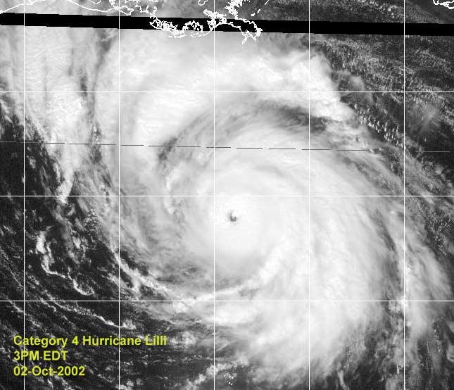
Moving Northwest toward western Louisiana.
I hope your preperations are done and you are out of the evacuated areas. If not, quit looking at this screen and do what you must.
Apologies for the slowness. It is network troubles at our hosting site, it is being worked on.
2PM EDT Update:
Hurricane Lili now a category 4 system, with winds of 135MPH and a pressure of 941 millibars. Warnings remain the same. This type of storm is capable of a 10-15 foot storm surge.
11am EDT Update:
From the hurricane center:
STOP THE PRESSES...THE LATEST FIX FROM THE HURRICANE HUNTER... RECEIVED JUST AFTER THE REST OF THE ADVISORY PACKAGE WAS TRANSMITTED...INDICATES THE PRESSURE HAS DROPPED TO 948 MB. SHOULD THIS BURST OF INTENSIFICATION CONTINUE...THE INITIAL AND
FORECAST INTENSITIES WILL LIKELY HAVE TO BE REVISED UPWARD ON THE NEXT PACKAGE.
Lili now a CAT 3 Hurricane with 120mph winds (and probably stronger with the hurrcane center's last minute comment) / 948 mb moving NW at 15
Original Post
The space shuttle is grounded today (launch was scheduled for today) over fears that the storm may interrupt mission control operations in the Johnson Space Center in Houston, for one good reason.
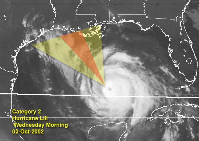
Hurricane Lili is a strong category 2 storm this morning. Some voluntary evacuations have been issued along the Louisiana coastline, and I'd recommend anyone in the hurricane watch/warning area prepare for the storm. I believe it will strengthen later today into a 3, and possibly close in on a high 3 low 4 before making landfall midday tomorrow.
Today is the day to prepare folks, and to make decisions. Go by how your area is and by what local authorities and news media pass along. The string of 3 years without a hurricane landfall in the US is about to end with a major making landfall.
Updates to the news will be coming as the situation warrants. Posts letting everyone know what's going on in the affected areas are welcome, but please make sure you are safe.
Beaumont TX TV: KFDM
New orleans TV: 6 4
Baton Rouge: wbrz 2
Kyle has restrengthened once again, and amazingly is still up in the air as to what it may eventually do. "We're still on ya Kyle, don't try to sneak in on us."
NRL Monterey Marine Meteorology Division Forecast Track of Active Systems (Good Forecast Track Graphic and Satellite Photos)
NASA GHCC Interactive Satellite images at:
North Atlantic Visible (Daytime Only), Infrared, Water Vapor
Some forecast models:
NGM, AVN, MRF, ETA ECMWF
DoD Weather Models (NOGAPS, AVN, MRF)
AVN, ECMWF, GFDL, MM5, NOGAPS, UKMET
Multi-model plots from WREL
Other commentary at Mike Anderson's East Coast Tropical Weather Center, Robert Lightbown/Crown Weather Tropical Update Accuweather's Joe Bastardi, Hurricane City Weather Audio Broadcast Network - Live Audio from Jim Williams and Barometer Bob , mpittweather , Tropical Weather Watchers.Com (JasonM) Gary Gray's Millennium Weather, Barometer Bob's Hurricane Hollow, Snonut, Ed Dunham and Jason M in our Storm Forum Even more on the links page.
- [mike@flhurricane.com]
| jth |
| (Storm Tracker) |
| Wed Oct 02 2002 01:32 PM |
|
|
It may just be me, but has Lili turned NW lately and even a little bit north of NW? I know it shouldn't be happening yet, but it sure looks like it to me. Oddly enough, it even looks like she is slowing a little. Probably just a temporary delay though. New Iberia beware.
| Unregistered User |
| (Unregistered) |
| Wed Oct 02 2002 01:36 PM |
|
|
Looks like only .1 of a degree North to me since 8 AM advisory, but I'm a newbie!
| Southern4sure |
| (Weather Guru) |
| Wed Oct 02 2002 01:37 PM |

|
|
|
oh dear, I hope this isnt a change in direction. I wil stay on this board all day!
Southern
| HanKFranK |
| (User) |
| Wed Oct 02 2002 01:47 PM |

|
|
|
kyle has a banding type eye-spot on visible. just still no steering currents.
anyhow, lili leveled off the morning, not the rapid deepening rate seen overnight. if lili stops right here, louisiana gets the storm nhc has been putting on the official (winds with a 954mb hurricane usually in cat 3 range). however, i can envision lili having another rapid deepening phase later today. will see.
94L much less organized than i was thinking. some of the convection has peeled back, revealing that there isnt much more than a weak low at the southern end of the convective mass. waiting on marco then, i guess.
HF 1347z02october
| Unregistered User |
| (Unregistered) |
| Wed Oct 02 2002 02:08 PM |
|
|
Latest Fix shows Max Flight Level Winds found to 125 KTS.
Doesn't that correspond to about 105-110 knot surface winds? Gotta be a cat 3 next advisory you think.
| Unregistered User |
| (Unregistered) |
| Wed Oct 02 2002 02:18 PM |
|
|
kyle getting much better organized.
| jth |
| (Storm Tracker) |
| Wed Oct 02 2002 02:18 PM |
|
|
I think that corresponds to 110 -115 k winds at the surface. Though this would suggest 130MPH winds, the next advisory will probably only increase to 115-120.
| Unregistered User |
| (Unregistered) |
| Wed Oct 02 2002 02:56 PM |
|
|
I can't believe New Orleans is still asleep...
The least they could do is say something...
| Unregistered User |
| (Unregistered) |
| Wed Oct 02 2002 03:04 PM |
|
|
I guess everyone will see this at the end of the 11 am discussion:
STOP THE PRESSES...THE LATEST FIX FROM THE HURRICANE HUNTER...
RECEIVED JUST AFTER THE REST OF THE ADVISORY PACKAGE WAS
TRANSMITTED...INDICATES THE PRESSURE HAS DROPPED TO 948 MB. SHOULD
THIS BURST OF INTENSIFICATION CONTINUE...THE INITIAL AND
FORECAST INTENSITIES WILL LIKELY HAVE TO BE REVISED UPWARD ON THE
NEXT PACKAGE.
| Unregistered User |
| (Unregistered) |
| Wed Oct 02 2002 03:06 PM |
|
|
To all of those that will feel the wrath of LILI I just want to let you know that My thoughts and prayers are with you.
Toni
| Unregistered User |
| (Unregistered) |
| Wed Oct 02 2002 03:23 PM |
|
|
Honestly, tho we all are very interested in these storms, with their beautiful satellite signatures, and the raw power of nature, and we would all like to experience a hurricane at least once (a minimal one), the latest images of Lili are downright frightening. If you are anywhere on the coast in Louisiana, batten down, or get out. This is a very serious situation, and my thoughts go out to all of you up there. Be SMART about this.
| Steve |
| (Senior Storm Chaser) |
| Wed Oct 02 2002 03:24 PM |

|
|
|
Hank Frank did a good job with his intensity forecast, and he claims not to be a guru! HA! LOL. Things are getting interesting. I hope the storm moves in down in the marshes. Cameron Parish (and whatever one is right east of it) 'way down there' are major rice farming areas. There aren't a lot of people there except country folk and farmers. Whomever suggested that it's a big recreational area down there is right. I've only been down to the coast on that side twice. You take Hwy. 27 south from Sulphur (just west of Lake Charles). There are a few towns (Hackberry, Cameron) with maybe a thousand or so people, but there is an abundance of wildlife and waterfowl down there. Otherwise, there are a lot of rice farms. The only population centers of note are (1,000-200,000) are Sulphur, Lake Charles, Lafayette, New Iberia, Franklin, Crowley, Abbeville and a couple other villages and towns. I like rice as much as the next guy, but if it's rice farms that need to pay, so be it. They're flooded terraces anyway!
Steve
| Frank P |
| (Veteran Storm Chaser) |
| Wed Oct 02 2002 03:26 PM |
|
|
What an impressive system, esp on IR... amazing... this thing has the real chance of being a Cat 4 prior to landfall.... Lili still seems to be tracking off to the NW somewhere between 300 and 310 degrees... typical wobbles as expected in the track... Your heart goes out to anyone who falls in its eventual path... right now the SW coast of LA looks to be targeted.... S Central LA will also take a serious pounding.... she is due south of Biloxi right now, and moving off to the NW certainly gets us out of any danger from her... whew.. thank goodness.... this very well might end up being someone's storm of the century....
| HanKFranK |
| (User) |
| Wed Oct 02 2002 03:40 PM |
|
|
|
|
ah, wouldnt go so far as that. the century is still quite young, indeed. btw steve my intensity forecast has been consistently too low. should be 105mph, 963mb right now if i was verifying.. 15mb and mph too low. incedentally i had it at the current numbers.. 120mph/948mb.. at 11pm eastern tonight. dont think the dry air entrainment will cause much of a problem, there isnt a heck of a lot of subsidence.. and what is there is mostly off to the left of the path. my beaumont/sabine pass landfall point is going to be too far west. looks like it's going in near the cameron/vermillion parish line. jennings, crowley, abbeville look to take the hardest hits.. core of the strongest winds should come inland between lake charles and lafayette. may be hurricane force winds as far inland as alexandria. the landfall zone isnt a heavily populated area, so total storm damage shouldnt be as high as if the storm went in right over port arthur or new iberia.
kyle.. where is that westerly push under the ridge? storm hasnt moved much in the last three days.. thought deepening would fix that. the official still takes it sw eventually.. will see.
HF 1540z02october
| Unregistered User |
| (Unregistered) |
| Wed Oct 02 2002 03:44 PM |
|
|
are evacuating all their aircraft from Ellington field right now. I know that this is a precaution to protect their multi-million dollar aircraft inventory but how much is a life worth?
Obviously the TPC is very confident of their track, but the margin of error is small. An 8 or 10 hour delay in a northward turn puts a major metroplitan are in danger with little time left to prepare. We are rapidly approaching the point of no return for an evacuation of Galveston Island.
I hope for the TPC's sake and ours in SE Texas that they are correct.
I
| Steve |
| (Senior Storm Chaser) |
| Wed Oct 02 2002 03:45 PM |
|
|
|
|
6th storm of the year to bring rain to my house. That's a record for me.
Steve
| Bruce |
| (Weather Guru) |
| Wed Oct 02 2002 03:50 PM |
|
|
Steve, how far away are you from where lili should make landfall?
| Steve |
| (Senior Storm Chaser) |
| Wed Oct 02 2002 04:02 PM |
|
|
|
|
especially 'as the crow flies.' The interstate runs NW before it turns west again. Using the I-10 from memory, It's 80 miles to Baton Rouge, then 47 to Lafayette. New Iberia is probably 35 miles south of Lafayette or so. Lake Charles is 72 miles west of Lafayette. So using those figures, Lake Charles would be about 200 miles west of me no the I-10 and maybe 170 (?) on a straight line. Metairie is suburban New Orleans. We're immediately (and abutt) the city to its west. If you look at a map and don't know where New Orleans is, look at "LA" and you'll see Lake Pontchartrain in the SE corner of the state. The city borders the lake to the South. The western periphery of the lake is about 20 miles WNW from where I live.
Hope that kindasorta makes sense.
Steve
| Unregistered User |
| (Unregistered) |
| Wed Oct 02 2002 04:03 PM |
|
|
Good Luck to those of you in LA.. I hope everyone is prepared for the aftermath.. Man, it brings back bad memories from Andrew. The hurricane is intense, but living with the aftermath for months afterwards sucks.. Just be prepared and no hurricane parties.. You will need 100% of your senses.
| Unregistered User |
| (Unregistered) |
| Wed Oct 02 2002 04:06 PM |
|
|
It seems Lili has suddenly slowed down and is hardly moving, north if anything...or am I seeing things?
IHS,
Bill
| Unregistered User |
| (Unregistered) |
| Wed Oct 02 2002 04:23 PM |
|
|
I noticed that too BIll, a tiny jog. You can watch this thing frame by frame on the Navy's satellite.
But I have to say the margin for error as far as this thing hitting the Houston area is too close for comfort. Hope Mom decided to take a drive north.
| Steve |
| (Senior Storm Chaser) |
| Wed Oct 02 2002 04:25 PM |
|
|
|
|
That's the ultimate disaster scenario for N.O. As I noted yesterday, it's 72 hours to evacuate the city. They don't have 20 as it is now. Bob Breck's key was the lattitude when it crosses 90. If it crossed 90 at 25.2, then it was on NHC track, anything above 25.2 would put it to the right. I haven't looked at the sat lately but I guess I need to go do that now!
Steve
| Frank P |
| (Veteran Storm Chaser) |
| Wed Oct 02 2002 04:32 PM |
|
|
Here's my rationale... it could be the storm of the century to the people most affected by it... I'm not saying from the year 2002 to 2102 per se.... but it's affect on the individuals during their life time...
Case in point... I'm 50 .... I've experienced my storm of the century during Camille... I doubt that I ever experience another one.. at least I hope.... I've been through some strong Cat 2s but that about it... statistically speaking, and you know your statistics, the chances of me going through another Cat 5 is extremely remote...
HF... how many Cat 4s have you been through??? ... I mean taked a direct hit from it... in the eye wall sort of thing... probably not very many... it is not that often that someone experiences a direct hit with a Cat 4 and even less with a Cat 5.... Of course this is all speculation as Lili has not yet gotten to Cat 4.... but IMO, if it does, then she most likely will be the storm of the century for those poor people who will go through her eye wall and areas just east .... Just like Andrew was the storm of the century for the residents of S Fla and Hugo was the storm of the century for those people in SC that experienced his fury.... Lili might just be the storm of the century for SW LA... my opinion....
| jth |
| (Storm Tracker) |
| Wed Oct 02 2002 04:33 PM |
|
|
It will definitely be north of 25.2 when it crosses 90. It should be more like 26 or 26.2. (at the current motion)
| Frank P |
| (Veteran Storm Chaser) |
| Wed Oct 02 2002 04:48 PM |
|
|
Looking at the GOES loop doesn't look like it slowing down to me.... if it is, its not that evident yet... unless I don't have the latest images to look at.. it still looks NW I could be using old frames... Using the GOES 15:45 UTC IF I have the center at 25.14N and 89.16W
If someone has a better link to show this slowdown I'd sure like to view it...
ciao
| Mary K. |
| (Weather Guru) |
| Wed Oct 02 2002 04:50 PM |
|
|
I have been following your thread. Since it appears the storm will be north 25.2 before it gets to 90 what does that mean for the people on the northern gulf coast.? Some of us (me) are not very bright about reading maps even though I know where LA, Missi,Ala and by all means, Texas is. Please some one lay it out for us. Iam not on the northern Gulf coast but my family is.
| Unregistered User |
| (Unregistered) |
| Wed Oct 02 2002 04:51 PM |
|
|
Baton Rouge is beginning to prepare for the possibility of hurricane force winds beginning tomorrow morning. The local weather in BR is reporting that this is a very serious situation and that all residents south of I-10 between BR and Lake Charles need to be prepared soon! Traffic here in town is horrible. And, I heard that they are getting out of New Iberia by the truckloads! Heading for Alexandria. Louisiana, stay safe, and listen to your local stations for watches and warnings. Kimmie
| Steve |
| (Senior Storm Chaser) |
| Wed Oct 02 2002 04:54 PM |
|
|
|
|
It doesn't mean a whole lot for me other than I'll be closer to the center (25-50 miles?) and likely to see a little more rain or wind. Of course he put out that information at 7am and obviously NHC did adjust their track a bit to the right. One of my attorney's down in Lafayette said they're reporting down in Acadiana that Intracoastal City is probably where it's going in - putting him on the East side. Lafayette is pretty high (by LA standards), but they're sure to experience widespread power outages and probable gusts to Hurricane force. Lafayette metro is about 350k (Lafayette, Broussard, Youngsville, Cade, Scott, Jeanerette, New Iberia, etc.) and likely to be the most heavily affected area as it looks now.
Steve
| Steve |
| (Senior Storm Chaser) |
| Wed Oct 02 2002 05:00 PM |
|
|
|
|
He likes a westerly solution 60 miles further over than NHC. He's nearly convinced. To me, I see much more NW at this point. Who knows?
Steve
| Steve |
| (Senior Storm Chaser) |
| Wed Oct 02 2002 05:06 PM |
|
|
|
|
He proposed a very interesting solution of the European Model which basically brings a positively tilted trof that MISSES Lili and sends her right over New Orleans on Saturday. Stranger things have happened, but the ECMWF was extremely good with Isidore. As Joe said, "food for thought."
Steve
| jth |
| (Storm Tracker) |
| Wed Oct 02 2002 05:20 PM |
|
|
latest recon found 941 and a 131kt flght level wind. WOW!!!!!! I don't understand Joe B. logic on this one. Lili has been consistently right of the models tracks (allbeit barely off). I believe she is right of the current track already. New Iberia is still my target if not a little east of there still. She is turning more and more north with each wobble. I just hope the turn NE waits until after landfall. If it occurs a little sooner, look out. I must admit I never thought she would get this strong. Goog luck to all.
| Unregistered User |
| (Unregistered) |
| Wed Oct 02 2002 05:34 PM |
|
|
No doubt it will be north of 25.2 when it crosses 90. It's already at 25.2 or better and still has almost a degree to go to get to 90. Looks like a wobble or a slight job to the north.
| Unregistered User |
| (Unregistered) |
| Wed Oct 02 2002 05:40 PM |
|
|
Whats the best site you guys are all using to watch the storm frame to frame? I am not sure if the ones I look at are updated frequently enough.
Thanks
| Unregistered User |
| (Unregistered) |
| Wed Oct 02 2002 05:43 PM |
|
|
http://www.nrlmry.navy.mil/tc-bin/tc_home
I've been using this website but I'm curious what others watch, too.
| jth |
| (Storm Tracker) |
| Wed Oct 02 2002 05:51 PM |
|
|
Last few frames show a turn more NNW. Like Joe B I am a believer in patterns. This year, the pattern has been for these storms to find a home near 90. I don't see Lili deviating far from this pattern. I don't believe she will make it past 92. If i'm wrong, I will eat my grilled crow on the grill while tailgaiting in the rain in Tuscaloosa this weekend.
| Unregistered User |
| (Unregistered) |
| Wed Oct 02 2002 05:51 PM |
|
|
This is the one I've been looking at.
http://www.ghcc.msfc.nasa.gov/GOES/goes8hurrir.html
| Unregistered User |
| (Unregistered) |
| Wed Oct 02 2002 06:12 PM |
|
|
Holy smokes! Hang on folks!
| Rasvar |
| (Weather Master) |
| Wed Oct 02 2002 06:26 PM |

|
|
|
Cat 4 possible Cat 5. I would not be taking a chance if i was in Galveston to NO. Anything within 15-20 miles of the coast, i would be loading up the car and heading inland. I would not want to take the chance of a wobble her or there bringing the most intense 25 miles of this storm overhead. I can see a Hugo type situation with a 10-20 mile wide stretch of heavy damage for up to 50 miles inland along the center of the storm. My advice to you if you are reading this board with in 15-20 miles of the coast in the warning area: Turn off the computer, pack the car and GO!
| tom5r |
| (Weather Watcher) |
| Wed Oct 02 2002 06:32 PM |
|
|
A cat 4 indeed! She's now a potential killer if she wasn't already. All in the warning area should get out now while you still can. The outer bands are becoming visible on the lake charles long range radar. Time's running out.
| Unregistered User |
| (Unregistered) |
| Wed Oct 02 2002 06:32 PM |
|
|
I have been a regular visitor to this site for years but very rarely post as I am a novice (though I have learned much from all of you). I lived through Hugo in 1989 and get chills when thinking about the effects this storm is going to have on LA. Unless something changes drastically over the next 24 hours, Lili will certainly be categorized with the Andrew's and Hugo's as three of the most powerful storms of our time. To all those in the storm's path, God Bless and be safe. Thanks to you all for making this a fantastic site and allowing us amateurs to learn a thing or two.
| Kevin |
| (Weather Master) |
| Wed Oct 02 2002 06:35 PM |

|
|
|
Central Louisiana is in the direct target zone of Lili...I hope everyone is prepared and I also hope that everyone that should be out is out. Lili is definitely going to challenge Andrew...he had a central pressure of 931 or 932, I think Lili will strongly challenge that or beat it.
My intensity forecast, unfortunetly, is turning out to be very good and perhaps a bit low. I said 120 knots at landfall...I'm too low. Going to go ahead and say 130 knots now. If Lili hits a populated area she may be just as bad as Andrew.
Kyle is meandering around. I'd expect that the NHC track will verify, but he will be out there a long time in any event.
Gulf Coast, batten the hatches if you haven't already! Good luck to all in the storm's path.
Kevin
| Unregistered User |
| (Unregistered) |
| Wed Oct 02 2002 06:36 PM |
|
|
According to the data at the NHC, Lili rates as the 15th strongest storm of all time right now. Of course, those stats were at landfall. However, with 24 hours plus til landfall, I would expect Lili to easily make it to the top 10 and looking hard at the top 5 of all time considering she dropped 12 MB in the last 6 hours since 8 this morning. I don't think the "storm of the century" label was that far off the mark at all, even though the century is still young. Good luck to everyone in Lili path.
| HanKFranK |
| (User) |
| Wed Oct 02 2002 06:38 PM |
|
|
|
|
7mb drop about three hours.. yeah, i'd call it rapid intensification. funny that lili is going right across isidore's path a week ago, and is doing all this deepening. the forecast landfall intensity is now 125kt.. if it does that, this will be the strongest u.s. hurricane since andrew. i dont think lili will get too much stronger.. say, deepen much past 930mb.. but it could. official track now to sw louisiana instead of the central part.. this is what ive been expecting to happen. might hit cameron head on.. and produce results like audrey did in '57. inland damage probably very heavy around lake charles up towards leesville.
interesting that bastardi is talking about kyle lurching westward. the thing is nearing hurricane strength again.. the eyespot i saw this morning is becoming a real eye. bastardi says it could go west at 15mph tomorrow.. considering that kyle has rarely gone over 10mph during its 11 day life span.. id be impressed to see that.. dont expect it. modeling now more or less takes kyle a little west as a weak system and then merges it into the trough following recurving lili. throw in a stronger system.. hell, i dont know what happens.
94L.. none the better. still plenty of models trying to resolve something out in the central atlantic, and i want my marco this week.
frank p.. hey, about the storm of the century semantics.. i know what youre talking about. this is a big deal sw louisiana storm, rare. theyve had audrey in 1957 and one like it in august 1918.. im not sure of any others that compare. but if you wanna get technical, this isnt a storm of the century but more of a half century storm, since this seems to happen about every 40 years. nothing to mock, i know.. i dont live at the coast so havent seen any camilles.. hugo and opal just gave me winds near/at hurricane force 100 miles inland, not the real mccoy. ive got the feeling that cameron louisiana will be destroyed in about 24 hours.. anybody else sensing that?
HF 1836z02october
| Unregistered User |
| (Unregistered) |
| Wed Oct 02 2002 06:47 PM |
|
|
Andrew was 922 milibars at landfall. Hugo was 934. Lili is already 941 and dropping fast. Its anyone's guess if the warmer sst's will have any effect on her or not, but she is certainly in range for top 10, perhaps even top 5. Camille was 909....
BE SAFE all of you. God, this one is a bad one...
| Domino |
| (Weather Guru) |
| Wed Oct 02 2002 06:53 PM |
|
|
Well my last post last night I said I couldn't figure out why Lili wasn't forcasted to be a Cat 4 by landfall...now I can see why I couldn't figure that out. This is going to be one hell of a storm.
| tom5r |
| (Weather Watcher) |
| Wed Oct 02 2002 06:56 PM |
|
|
I agree Hankfrank! I foresee total destruction in Lili's path. I remember Arlen Spector comparing Andrew's destruction as being equivalent to a multi nuclear strike. I fear LA is going to experience the same scenario. May God have mercy on all in the area.
| Unregistered User |
| (Unregistered) |
| Wed Oct 02 2002 06:57 PM |
|
|
OK, everyone take a deep breath....
First, it MAY get to cat 5...you have to remember as it approaches the coast:
1. eyewall replacement cycle fluctuations---it may get to Cat 5, but will it be a Cat 5 at landfall?
2. N/NW Gulf water temps are lower than where Lili is now...this may retard the strengthening. In fact, I've noticed a little pool of cooler water just to the right of the path..Isidore?
3. Dry air entrainment and shear may begin to pick up in the next twenty four hours.
4. Remember Opal (re: cycles)...it was nearly a five, lowered to a borderline 2/3 in a few hours just before landfall. Granted, the environment was a lot less favorable..just a cautionary note.
Having said all that---I still think it will for sure be a three, probably a four, chance of a five at landfall.
Next----where is it going?
First, it is moving to the right of the forecast track. Unless it corrects, this deviation will magnify over time. And, it may turn more to the N..we do not know yet. This slight deviation is the first 'crack' in the modelling 'armor'. We will know if it really mean something by 5...and if the storm also slows down, there could be a considerable track deviation.
What I am saying is that a 40 mile deviation to the right (what we have now) does not necessarily translate to 40 miles at landfall..it will probably be more.
As for me, believe the landfall 'marker posts' will be Central La coast eastward to Pascagoula...and actually, ultimately. I favor Pascagoula, maybe clipping Buras on the way- or even NO, depending on time/angle of the turn.
Time will tell!
IHS,
Bill
| PFSThunder |
| (Weather Watcher) |
| Wed Oct 02 2002 07:22 PM |

|
|
|
Help is on its way. South Fl. to the rescue. I was on the Florida Turnpike at noon and a large convoy of FPL trucks on the way to restore power after whatever happens. Returning the favor in a time of need.
| Unregistered User |
| (Unregistered) |
| Wed Oct 02 2002 07:24 PM |
|
|
I was kidding about the cat 5 stuff...come on...simmer down lili!!!!
My worst fears were it would hit NO....as a biggee....shoot...it could hit ME!.....
| Southern4sure |
| (Weather Guru) |
| Wed Oct 02 2002 07:29 PM |
|
|
|
|
Bill, do you really feel it is slowing down and moving a little north?
Southern
| Frank P |
| (Veteran Storm Chaser) |
| Wed Oct 02 2002 07:29 PM |
|
|
Pretty gutsy call Bill... don't necessarily agree with it but gutsy no less.... However, I do agree with most of the rest of your post .... slight deviate now could mean larger later (without corrections) .... remains to be seen if the deviation from track continues.... Hard to believe it could get to five based on your rationale below... they are just so scarce to come buy... every thing has to be perfect atmosherically....
Latest model runs have have shifted to the east by approximately 1 degree or so...
HF.... you get my point.... for all practical purposes 100 year events related to weather seems to occur every 50 years of so... next 24 hours is going to be some intense stress for those in the target zone...
| mbfly |
| (Weather Guru) |
| Wed Oct 02 2002 07:35 PM |
|
|
|
|
Pascagoula, huh ?? That's a little too close for comfort...... I was still thinking more toward the west; TX/LA border. Regardless, the poor souls in LA, NO, etc are going to catch Hell. I hope they have prepared and that none of them is thinking this will be a "fun" experience. Having gone through Frederick in '79, I know now what it is like to go into such a storm anticipating not much more than a 12 hour thunderstorm ! Believe me, spending the night in the hallway of a little bitty wood frame house with a husband, a 2 yr old, a German shephard and a Chihuahua with winds at 100mph or so was NOT fun. I wouldn't want to do it again.
| Unregistered User |
| (Unregistered) |
| Wed Oct 02 2002 07:40 PM |
|
|
Southern--
I am not sure about the slowing down...it was at 16mph, slowed to 14mph, then is up to 15mph at latest update...so, a slight slowing.
RE: moving more north/east, yes, it has deviated, but it remains to be seen if this is a jog or other temporary motion. I am beginning to see some evidence that the s/sw flow to the west of the storm is beginning to impact on the outflow level---TPC/NHC admits as much when they said that outflow is restricted in the sw quad (in a discussion earlier today).
IHS,
Bill
| Unregistered User |
| (Unregistered) |
| Wed Oct 02 2002 07:45 PM |
|
|
Hurricanes tend to go 5 degrees right of the axis of clouds...this one has the axis heading more north than west. It will turn north, possibly even begin going east...before landfall. I am in total agreement with Bill.
One thing for sure. It is WAY to early for ANYONE to say where it will go. Unbelievable that the "experts" have the stupidity to assume they "Know"....Now there is NO WAY New Orleans can be evacuated...in fact...if this thing makes a 5...which I think we all know now is possible...and then makes an unexpected landfall somewhere that is in a moderate danger zone...then the people will be stuck with a killer storm...and NO TIME TO GET OUT>>......
sorry...but for those who kept saying it would go yadd yadda yaddda.....in Tx...they IGNORED the fact that NO ONE can EVER predict where it would go...and it is and should be up the the authorities to tell them it could go anywhere!!!!!!
too late now...hope it stays west where the people are preparing..cause if it heads towards Mississippi and Alabama......
party's over if it does...no one is ready...No one here in Mobile is even worrying about it...PERIOD...they all think it is hitting way west of here...
so I think it is a sham...the "experts" are too cocky...and this one will humble them...they ought to be saying ..."NOT sure where it will go"...not projecting some point as though they knew....
really makes me mad...as you can probably tell.....
I fear a lot of deaths if this track keeps heading east....I really do.
| Southern4sure |
| (Weather Guru) |
| Wed Oct 02 2002 07:48 PM |
|
|
|
|
Thanks Bill for your quick answer. Im just a novice here and I have learned alot, but have alot more to learn. I have been using this site for several years. This board has been a real help to me.
Southern
| Unregistered User |
| (Unregistered) |
| Wed Oct 02 2002 07:50 PM |
|
|
I don't think Lili will get much stronger than 115 kts--according to SST maps, the waters of the Gulf cannot support a hurricane stronger than 115 kts.
| Unregistered User |
| (Unregistered) |
| Wed Oct 02 2002 08:06 PM |
|
|
In viewing the latest loops, the storm is clearly moving more to the north, it still has not crossed 90 west, in fact, if you look at the 3pm pic on the front page of this site, you can see it is still clearly east of 90 west...the loops show a turn more to the n, probably 320-325 degrees in the last hour or two.
This of course may change, stay tuned....if this trend continues, seems like NHC may make some adjustments at 5...look like a straight line would take it to the central LA coast now, but, with rare (Andrew) exceptions, hurricanes do not move in straight lines.....
IHS,
Bill
| cappycat |
| (Verified CFHC User) |
| Wed Oct 02 2002 08:47 PM |
|
|
We are ready to weather the storm...at least all the preparations are done. Not sure if anyone is ever ready for a cat 4!!! We are east of the projected track, but still shaking in our shoes. The forecasters here are saying that New Orleans is in the clear (but to stay alert and prepared) but I'd rather err on the side of caution. We are boarded up for bear... still I was shocked at how many homes were NOT boarded up. Folks here are either of the persuasion that we are fine, Lake Charles is going to get it, or they are running around in a panic. Since we left all our boards up and ready since Isidore, we are just prepared. SC La is not out of the woods yet, in my uneducated opinion!
Keep us Cajuns in your prayers, folks.
| WXMAN RICHIE |
| (Weather Master) |
| Wed Oct 02 2002 08:52 PM |

|
|
|
Winds up to 140 mph!!!!!!!!! WoW!!!!
| jth |
| (Storm Tracker) |
| Wed Oct 02 2002 08:54 PM |
|
|
Another slight eastward shift to the projected path. I still don't see her ever getting past 92. I am now leaning toward almost not getting past 91. She has undoubtedly shifted NNW at best the past couple of hours. The turn north will then follow and then NE. Bill you may not be that far off. Admittedly I thought you were nuts at first, but now........Everyone say your prayers for the Cajuns and the revelers in the Big Easy.
| Bruce |
| (Weather Guru) |
| Wed Oct 02 2002 09:11 PM |
|
|
Cappycat, smart move. I feel you will be about 60 miles from the eye wall. Any shift to the East will put you closer. I think early morning hours, around 9am landfall. Good luck!!!
| Unregistered User |
| (Unregistered) |
| Wed Oct 02 2002 09:12 PM |
|
|
whats going on i am in pensacola i dont wanna wake up with a cat4-5 right south of biloxi or mobile or pascagoula. but i seen the turn everyone is talking about i dont think we are outta the woods yet by any means. god bless the folks in the path of the storm though.
| WXMAN RICHIE |
| (Weather Master) |
| Wed Oct 02 2002 09:21 PM |
|
|
|
|
At 938 mb, Lili would tie for #13 on the all time lowest pressure list (at US landfall).
| Unregistered User |
| (Unregistered) |
| Wed Oct 02 2002 09:24 PM |
|
|
Ok, based on the current motion, etc, I am going to throw in the towel on Pascagoula and go with Intracoastal City - up to 50 miles ot the east as the landfall zone...there may still be a sharp recurve just at or after landfall that will take the center over southern Ms , we will see....
315 degrees instead of 320-325...I was off just a bit, but it is turning more north with time..timing as always is everything...
IHS,
Bill
| cappycat |
| (Verified CFHC User) |
| Wed Oct 02 2002 09:39 PM |
|
|
Just watched three different weather updates and all of them have shifted the projected land fall east. oh joy. They had landfall at New iberia, but conceding that the track could possibly be shifted even further east.... another one said closer to Morgan City. I wasn't scared until now.
Our house is built up into the loft of a barn, so no fear of flooding. Water would have to be 14-15 ft deep to get to our front door. It is a steel structure, anchored into an 8 inch slab of concrete. We weathered Andrew at my father's house, but suffered no wind damage or leaks at our home. I am wondering about what wind of 140 mph will do to such a structure. My father (next door) has NOT boarded up at all, so I am thinking that here may be safer than there, even though we are up so high. babbling out of fear, now. Oh!!! we need to take down the direct tv dish!!!!
Wish we had taken up the invite to Birmingham.
| Unregistered User |
| (Unregistered) |
| Wed Oct 02 2002 09:49 PM |
|
|
I've liked my forecast track from the beginning - St. Mary or Iberia Parish. I used New Iberia/Franklin as the landfall locations, but obviously neither is right on the coast. Intracoastal City or Port of Iberia are probably gonna get slammed. I still think the center comes in around New Iberia, but obviously could be closer to Franklin or Morgan City. The parishes along the coast from the TX Coast to Mississippi are: Cameron, Vermillion, Iberia, St. Mary, Terrebonne, Lafourche, Jefferson, Plaquemines then St. Bernard and St. Tammany climbing up around the east side of the state toward the MS Gulf Coast.
FYI stuff.
Steve
| Unregistered User |
| (Unregistered) |
| Wed Oct 02 2002 09:56 PM |
|
|
I know its still conjecture at this point, and probably will be until sometime late tonight, but it still looks to me like a bee-line NW.
http://www.ssd.noaa.gov/PS/TROP/DATA/RT/gmex-vis-loop.html
I just don't see the nothward motion yet you are all seeing. I say watch out Vermillion. God, I hope those people got out of these.
By the way, I am pretty sure the outer eye-bands are visible on the NO radar now:
http://www.srh.noaa.gov/radar/loop/DS.p20-r/si.klix.shtml
| tom5r |
| (Weather Watcher) |
| Wed Oct 02 2002 10:05 PM |
|
|
The outer bands have been visible on NO radar for a while now. After these there should be a small break and then we'll see the meat of the storm moving in. Its gonna be an interesting night. I wonder how many of us will get any sleep tonight.
| cappycat |
| (Verified CFHC User) |
| Wed Oct 02 2002 10:06 PM |
|
|
re: folks getting out.... friends of mine left at about 1-2 PM from Houma. They are stuck in traffic in Des Allemends (a drive that normally takes 30 minutes).
| Bruce |
| (Weather Guru) |
| Wed Oct 02 2002 10:09 PM |
|
|
seems to be the center. will be able to get a good fix on her now. With her fast movement, landfall I say early morning hours.
| HanKFranK |
| (User) |
| Wed Oct 02 2002 10:23 PM |
|
|
|
|
i keep hearing its turning north its turning north.. getting a little old. pretty sure N.O. wont see more than some rain squalls.. none of that hurricane force wind business. alabama and mississippi.. its already past you guys.. forget there's a ridge steering it around ya? no need to have a conniption fit, unless youre an excitable cajun. heading on the last advisory was 315, which is due NW.. it's come around from 300 during the last 48 hours. probably still have a westerly component at landfall. beaumont is looking less likely now, cameron and vermillion have the bullseye on them. right side of the hurricane should come across as far over as new iberia/franklin/lafayette.. maybe hurricane force winds as far over as morgan city. idea is that the hurricane's core passes between population centers to the west (beaumont/port arthur) and east (lafayette/new iberia).. the hammer comes down in a less populated region. all of the coastal counties have mandatory evacs up for the low lying areas.. so if people drown down there its their fault for not leaving. dont imagine anyone wants to test lili's threat.
anyhow, intensity. 938mb.. pressure will probably not go much lower, think the storm is mostly done intensifying. probably just fluctuate around where it is, maybe weaken slightly right before it hits. turn north upon moving inland, and be going northeast by the time it reaches about 32n. this is the real deal.. right here and now it's on par with hugo at SC landfall.
i've been consistently low with my intensity track, and will probably end up being 50-125 miles too far west on the landfall point (not to mention a few hours late).. so like i keep saying, there aint no guru here.
well.. now, kyle. more consensus on it starting west.. how soon and how much will determine whether it threatens. if it deepens and moves out under the ridge periphery.. threat to the eastern carolinas this weekend, early next week.. and then up towards new england later, maybe. if bastardi is to be believed (thank God he's still online, thought he'd be a pay service by now).. and i put stock in things he says.. this could come to pass.
of course it could just stay put, dissipate.. or for some silly reason keep drifting east. slow moving storm with very little steering.. just cant say.
HF 2215z02october
| Southern4sure |
| (Weather Guru) |
| Wed Oct 02 2002 10:51 PM |
|
|
|
|
HF, I think your snide comments and self righteousness are getting alittle old:
i keep hearing its turning north its turning north.. getting a little old. pretty sure N.O. wont see more than some rain squalls.. none of that hurricane force wind business. alabama and mississippi.. its already past you guys.. forget there's a ridge steering it around ya? no need to have a conniption fit, unless youre an excitable cajun.
I really dont believe MS or AL have a chance of Lili being a direct hit, BUT if there is a chance a change in motion that (COULD) impact AL, I want to hear it. I have learned over the years at this board, that there has been lots of instances where you guys were right before NHC changed there track. I dont rely solely on NHC, I rely of this board.
If you disagree with my comments and questions, fine, but you are not going to belittle me for asking questions.
Southern
| LoisCane |
| (Veteran Storm Chaser) |
| Wed Oct 02 2002 10:55 PM |

|
|
|
Lets just pray it hits an area of less populated cities and that people drove north and took the safe road.
Surprised she went Cat 4, now wondering if she has peaked.
Don't think you can have it both ways... either she keeps moving fast and misses new orleans but will go in as a more dangerous cane.
The thought that it would hook right slow down a drop would make it hard to imagine it would keep intensifying.
Right now going with people here online who have insisted she should stay east of New Orleans.
Want people to understand that we don't wish this storm on any small parish but the levee system of New Orleans has always been in question for a Cat 3 storm let alone a Cat 4.
I's so amazing to watch that there isn't anything to say beyond pray, pack and Lili is one for the record books. Seeing history being made right before us with each shot.
She reminds me in structure of Andew but with the leaning in look of Hugo.. Scarey and numbing for those of us that know what a real storm can do...
| LoisCane |
| (Veteran Storm Chaser) |
| Wed Oct 02 2002 10:57 PM |
|
|
|
|
Some models called for a hard right turn... hoping it doesnt.. hasn't happened yet so lets keep our fingers crossed.
Neil Frank more than Miami forecasters seen on CBS tonight implied he was watching for the turn to come...but said it hasn't happened yet.
| Unregistered User |
| (Unregistered) |
| Wed Oct 02 2002 11:01 PM |
|
|
so a shift to the east 125 miles...and that's it?....
WRONG hank frank....
looking at the satelliltes...definitely slightly north of nw now...maybe not nnw for another few hours...however...this hurricane can easily take another 20 hours...and in the last 10 hours...we have seen a 15 degree shift...haven't we....?...all we are talking about now is about 30 degrees...or so...and the farther north it goes..the greater likelihood it wil turn further north quicker...
granted...it could even stay on its general path and hit central louisiana or so...
my take...
a gradual loop to knife through the lowlands of Louisiana...and either punish New orleans on the left, right, or dead center...
but to think New Orleans is out of the woods is wierd....to think that 20 hours from landfall the deviation won't continue to occur is belying the obvious. IT WILL continue to curve gradually around, and Bill's idea of Pascagoula is a savvy one. may not happen...but at least he threw it out there...
Pascagoula is in deep dooodooo
New Orleans is in deep doodoooo
No one in Mobile is taking this seriously....hopefully they and I are not in deep doo dooooo
| joepub1 |
| (Storm Tracker) |
| Wed Oct 02 2002 11:04 PM |
|
|
HankFrank, you are a guru. Well informed post, as always.
Very good point about non-LA people being worried. One thing that Lili is besides being stong: she's fairly compact. Other than those on the central LA coast who are say,50 miles on either side of the eye, and then take the track inland 100 miles or so, are in major danger. She's not going to stop. She's not going to suddenly turn west. She's not moving to the NE, still going NNW at worse, putting some distance between the big easy and the landfall. New Orleans isn't out of the woods by any means, but anywhere east of MS is your mind playing games with you. Watch her outflow, not just her center. If it points at you, you got a problem. It's northwest-southeast, pointing right at it's target, central LA.
Hopefully everybody on the coast is out of the way by tonight, my thoughts are with them and their loved ones. Buildings can, and will, be replaced. Alot of wildlife will find itself in new surroundings by friday morning. But any person who is in the path hopefully did the smart thing and left for higher ground, to say the least. Now's not the time to hope for good luck, it's tme to cover your ___.
Joe in Jax
| HanKFranK |
| (User) |
| Wed Oct 02 2002 11:07 PM |
|
|
|
|
ah, thats just me. when people keep calling the hurricanes to them all the time its a little funny. especially when it's clear as day that theyre in the green. if you dont want me to make fun of ya, easy on the 'it could hit me' melodrama, unless youve got a better reason than 10mph winds and mostly cloudy skies. that isnt mean or self-righteous.. pretty normal response. i may point out when other people are wrong.. but i spend just as much time pointing out where *I* am wrong. fair enough, eh? ¿no sé? its the bayou country of louisiana that takes this one on the nose.. not texas, not new orleans, not mobile. thats all there is to it.
HF 2306z02october
| Unregistered User |
| (Unregistered) |
| Wed Oct 02 2002 11:11 PM |
|
|
ya'll must be looking at it sideways...cause the main outflow is pointing directly north now....DUH
this thing is turning....and it ain't gonna miss nawlin's enough not to cause catastrophic damage...
imho
| Unregistered User |
| (Unregistered) |
| Wed Oct 02 2002 11:15 PM |
|
|
We got lucky again!
ShawnS
| Southern4sure |
| (Weather Guru) |
| Wed Oct 02 2002 11:15 PM |
|
|
|
|
I never said once that mobile was going to get a direct hit. I never said or hinted at be a wishcaster. I never hinted at 'it could hit me' . But if there is a post by a reliable poster, yes I pay attention. I would be out of my mind if I wanted this storm in Mobile, I was here in Frederick., thats was enough for me. Im a mom who wants to protect her children and if I can get quicker info from this board than NHC, so be it. But what I dont expect to have to put with is your snide comments. Like I have done over the years, keep them to yourself. The majority of us do until we are given enough reason to say hey! That was wrong.
Southern
| Bruce |
| (Weather Guru) |
| Wed Oct 02 2002 11:17 PM |
|
|
New Orleans is calling for 50 to 60 MPH Winds Thursday afternoon. Im going with New Iberia location.
| Unregistered User |
| (Unregistered) |
| Wed Oct 02 2002 11:20 PM |
|
|
look at the last two frames in the last hour or so...this ain't a wobble...this thing is now heading NNW.....that's a 45 degree shift in 10 hours gang....THINK...we have 20 to go before landfall...
anyone else see what I am seeing????
| Southern4sure |
| (Weather Guru) |
| Wed Oct 02 2002 11:21 PM |
|
|
|
|
Just a little FYI.. had a board like this been around back in 79, I would have paid closer attention to it instead of NHC. NHC let us down waiting until the last minute to give us a warning during Frederick. Excuse me for not giving them my full attention.
Southern
| Unregistered User |
| (Unregistered) |
| Wed Oct 02 2002 11:26 PM |
|
|
Last visible, I got the eye at 26.48, 90.24. Don't know how that corresponds to the 4pm advisory because I don't have another browser open. That's from the zoomed visible on Goes-8.
They are predicting TS force winds in here in the city beginning after 9 or 10 (possibly midnight). Definitely going to be some power out in the city! I lost my bag of AA's, so I gotta go dig in a little while.
Only Bruce Katz of ABC 26 (Cable #11) is playing the N'ward jog. It's pretty evident on his satellites that it's going between NW and NNW. Gut feeling is if this isn't a stair step, I'm too far west with Iberia/St. Mary, and maybejustmaybe anywhere from Port of West St. Mary to Terrebonne (Tera-bone). I still don't see a New Orleans hit. Only thing that would change with this type of jog would be putting the fringe areas west of Jefferson Parish (my turf) - say St. Charles, Lafourche, Ascension, Assumption, St. James Parishes could be on the edge of the Hurricane force winds.
Steve
| Justin in Miami |
| (Storm Tracker) |
| Wed Oct 02 2002 11:28 PM |
|
|
The real question is exactly how strong is Lili? Remember 10 years ago this year Andrew was believed to be a Cat 4. However, this year he was upgraded to a Cat 5. I recall a post earlier that said the atmospheric conditions are not perfect enough for a Cat 5...if not then I don't what is! This storm looks pefect to me. Also, I believe we will get to see some amazing damage and storm footage because the storm will strike during the day. I think I have an idea about what they are going to experience and wish them the best of luck.
| Bruce |
| (Weather Guru) |
| Wed Oct 02 2002 11:30 PM |
|
|
Gain of 5 north, 2 West since 4pm
| Justin in Miami |
| (Storm Tracker) |
| Wed Oct 02 2002 11:31 PM |
|
|
Steve, I look forward to reading your posts. Considering you are probably the only one in these posts that will experience the most of this storm...if there is anyone else please say so.
| DopplerGal |
| (Registered User) |
| Wed Oct 02 2002 11:33 PM |
|
|
You go girl. NHC let us down on Opal too. No mention it might really turn our way.
| Unregistered User |
| (Unregistered) |
| Wed Oct 02 2002 11:33 PM |
|
|
http://weather.abc26.com/global/Region/g1/2xpxIRSatellite.html
Click on his satellite and you can see where he was getting the northward jog. However, the last picture shows a definite shunt off to the NW after the last couple to the N/NNW.
Steve
| Unregistered User |
| (Unregistered) |
| Wed Oct 02 2002 11:33 PM |
|
|
They are predictiong tropical storm force winds here tomorrow but I don't buy it!
ShawnS
| turkeyman |
| (Registered User) |
| Wed Oct 02 2002 11:40 PM |
|
|
I see those last two frames Rick, and I definitely don't like it. Hanging plants still hanging, lawn furniture still in place, truck running on empty.......if you get my drift. I'm 45 mi N of New orleans, and they keep mentioning a "slice" to the NE once this monster hits terra firma. I was here in '69 when the eye of Camille came five miles from the house. I'll never forget the horror. It was a once in a lifetime. Also I noticed the forcast models just today, had TX in their sights. Not any more. As for where it's going,........I don't know.....no one does. Just don't want it here. But, I did see those last two frames.
| BillD |
| (User) |
| Wed Oct 02 2002 11:41 PM |
|
|
If anything in the last few frames (2310Z and 2315Z) its taken a NW wobble again. No clear direction change that I can see, yet. NO long range radar confirms this.
I think it would be helpful if everyone time stamps their comments (like I did) "the last frame" doesn't mean a whole lot when we are all looking at different sources.
Rick, I did see what you saw prior to these last two frames, and was in the process of posting a message in agreement.
Bill
| Unregistered User |
| (Unregistered) |
| Wed Oct 02 2002 11:45 PM |
|
|
The only way it will go west of New Orleans...is if it decides to STOP...
it is not yet n...but accounting for that wobble..it is now nnw...and soon to be nnnn.....by tonight late she will be nawtherly....then the question will be a shift east....imagine if it starts easterly at all...then it could slice and dice the gulf coast......
| Unregistered User |
| (Unregistered) |
| Wed Oct 02 2002 11:45 PM |
|
|
getting a little worried here in Baton Rouge--I agree with the rest of you who see a more nnw movement. I'm hoping that maybe a little dry air can get entrained into the circulation before landfall, but I don't have a good feeling right now. People talk about Andrew in Florida all the time, but it got pretty intense in this area as well--I hope we are not in for a repeat performance. What is Bob Breck saying Steve?
| Unregistered User |
| (Unregistered) |
| Wed Oct 02 2002 11:57 PM |
|
|
They eye is in long range radar site. Take a look at this:
http://www.srh.noaa.gov/radar/latest/DS.p20-r/si.klix.shtml
| recmod |
| (Weather Guru) |
| Thu Oct 03 2002 12:02 AM |

|
|
|
8 PM NHC update states:
REPORTS FROM AIR FORCE RESERVE AND NOAA RESEARCH HURRICANE HUNTER
AIRCRAFT INDICATE THAT MAXIMUM SUSTAINED WINDS HAVE INCREASED TO
AT LEAST 145 MPH...WITH HIGHER GUSTS
However, the central pressure has inched upward to 940 mb. At least this SEEMS to indicate that there should not be any further significant intensification (short term that is).
Lou
| wxman007 |
| (Meteorologist) |
| Thu Oct 03 2002 12:02 AM |
|
|
Steve, be careful....
If i was in NO tonight, I'd be making plans...I've got a hunch this thig is gonna be much further east that the NHC is calling for...gonna be close to NO, I'm afraid...
| cappycat |
| (Verified CFHC User) |
| Thu Oct 03 2002 12:07 AM |
|
|
<<<<Lafourche, Ascension, Assumption, St. James Parishes could be on the edge of the Hurricane force winds. >>>>
This is me...we are in Lafourche parish. Watching Bob Breck now and getting his take on this NNW "jog".
145 mph winds. how far out do the hurricane force winds extend? 40 miles?
|
MikeC
|
| (Admin) |
| Thu Oct 03 2002 12:09 AM |
|
|
Jason, if that happened. There is no time for any real sort of evacuation.
God I hope not. Would cause many heads to roll and be a horrible horrible case study.
You are wrong! (I hope)
| BillD |
| (User) |
| Thu Oct 03 2002 12:12 AM |
|
|
According to the 8PM advisory, 45 miles.
Bill
| Unregistered User |
| (Unregistered) |
| Thu Oct 03 2002 12:16 AM |
|
|
Could it be that lili could turn into a five?????
| wxman007 |
| (Meteorologist) |
| Thu Oct 03 2002 12:17 AM |
|
|
I really HOPE....REALLY, REALLY, REALLY hope I am wrong....but look at the general motion of the cloud canopy, and the direct of the blowoff...
I don't think it would be a direct NO hit, but it's gonna be closer than the Official track.
| Kevin |
| (Weather Master) |
| Thu Oct 03 2002 12:18 AM |
|
|
|
|
Lili remains very well organized, but as the 8 PM advisory said, the pressure has risen very, very slightly to 940 mb. What does this mean? Nothing. Unless something drastic occur overnight (i.e. Opal of 95), the 150 MPh wind gusts observed by buoys south of the Louisiana Coast will be coming ashore tomorrow afternoon. If there are some who live in Louisiana and haven't finished preparing, there is no use of doing so now. Better just evacuate to a shelter immediately. TS force winds are already approaching the Louisiana coast...the trouble is just beginning.
Once again, for all in Lili's path, I'll say good luck, stay safe, and most importantly, hang on to your ass!
Kevin
| Unregistered User |
| (Unregistered) |
| Thu Oct 03 2002 12:18 AM |
|
|
Don't laugh, but in the last few frames of the satellite loop I think I see an ever so slight westerly "jog" to the NW component of the movement of Lily. Doesn't mean anything, but I thought I would throw it in since everyone else was talking about the more northerly jog.
ShawnS
| Unregistered User |
| (Unregistered) |
| Thu Oct 03 2002 12:20 AM |
|
|
so what does everyone think. i am not as worried here in pensacola anymore. Probably just a 20mph breeze. Maybe a shower thats about it. Feel sorry for the folks in Louisiana cause us folks on the Panhandle could be in this same situation an i know i wouldnt wanna be.
| Unregistered User |
| (Unregistered) |
| Thu Oct 03 2002 12:21 AM |
|
|
Let's hope it has peaked....perhaps the eyewall will break down again...and rebuild stronger....if it tightens up...we got a cat 5.....this is not far from it....LOOK OUT>>>>>>>
this thing is gonna be bad.
| cappycat |
| (Verified CFHC User) |
| Thu Oct 03 2002 12:21 AM |
|
|
thank you. if it comes in at Morgan City we are in for some rough weather, but not inside of the 45 mi area. New Iberia would be even better!!! I still liked the Lake Charles track best though. sigh.
| Unregistered User |
| (Unregistered) |
| Thu Oct 03 2002 12:23 AM |
|
|
jason you say the storm could be going more east plue weather channel just said storm could be going more east plus someone said models are showing right turn what do you see and what does this mean thanks
| Steve |
| (Senior Storm Chaser) |
| Thu Oct 03 2002 12:23 AM |
|
|
|
|
and everyone else. Yeah, we're watching intently. I think TPC has got to nudge the track a bit to the right at the 10:00 advisory. Got the Benz (wife's - NOT MINE, I drive a 94 Honda which she gave me to replace my '88 Accord) gased up just in case, but we're planning on staying put for now. Surprisingly, everyone in the neighborhood who blew town for Georges is also hunkering down. So that would complicate any radical turns as there would literally be NO WAY to get even 1/3 of the people outta here. This isn't worst case scenario (Cat-5 moving up from SSE/SE just to the south of the city) that kills 100,000+ people, but you still have to respect it. I've got the kids life vests in just in case. It doesn't flood in my neighborhood, but obviously a levee breach ANYWHERE changes everything. So we're all set. I'm looking forward to tracking this with all you guys as long as I have power. I'm about 85% sure we'll lose power at some point, just don't know for how long. So I'll be back in as is possible.
Looks like this was Louisiana's year. Glad most of the storms (at least up unto now) have been wimpy because if this was our 4th or 5th direct hit, it would probably be the death knell!
L8R,
Steve
| Frank P |
| (Veteran Storm Chaser) |
| Thu Oct 03 2002 12:25 AM |
|
|
Posted two days ago this thing would NOT hit Texas... I think I got that one in the bag... also stated that Lili would be within 100 miles of New Orleans to the west... that might come to fruition as well (maybe)... have notice the big swing to the NNW...
I have not done any preps at my house... NONE... why? because I have been relying solely on what I though was a confident nhc forecast track... heck we don't even have a hurricane watch on the MS coast... I sure would hate to have to nail up plywood in gale force winds... shame on me... probably goning to be OK over here as long as we don't get any last minute surprises.. good thing Lili is a small compact storm...
On the sat pixs you can see the elongation of the system from north and south, usually an indication of where a system might eventually go.. it was NW to SE most of this afternoon, but now it a descernible N and S....
If A98E comes to fruition then the Big Easy might be the really Big Uneasy tonight and tomorrow...
all eyes will stay focus on the track for the next 6 -8 hours or so... will be critical
| Rick |
| (Weather Watcher) |
| Thu Oct 03 2002 12:26 AM |
|
|
I think you're right. Much too close to N.O. for comfort.
OK...here we go with the drama of "live TV news"!
I feel sorry for the poor reporters who got the short straw and have to go out in the weather to "get the story". (OK, that was great...now hold on to that stop sign and try to look......ummm....horizontal!)
I'll never forget ol' Norris Dejon from a West Palm station. They sent him out to cover some storm (I forget which) and to dramatize how "windy" it was, he took off his windbreaker and let go of it expecting it to go down the block. It fell straight down on his shoes!
Then you have the other extreme where the reporter can't even stay in the shot!
The WC guy Joe almost got run over earlier doing an interview in the street!
| Unregistered User |
| (Unregistered) |
| Thu Oct 03 2002 12:33 AM |
|
|
I have a feeling this storm wil cause the entire way they report these things to change. Problem is that there is still NO WAY to discern with any accuracy where they will go. ...and no one wants to evacuate the entire northern gulf coast.
but the delay in telling the public is wierd to me. People I am talking to are still thinking texas....WE ALL know what is happening...but the transfer of information is far too slow to help. The people need to transfer all of this info to a main site that the entire coast watches.....it could be a good thing...
everyone watches it....and changes occur immediately...and interviews...and discussions..
sooner or later..the big one comes....
nawlins.....takes it on the chin....
this is a bad thing ya'll. I mentioned a day ago New Orleans was a possibility...even east of that...and recieved flack and jokes...WHY?......if it is a possiblity....WHY ridicule it?..
Small hurricane with a buzz-saw solar system type look...
landfall at 140 MPH winds...maybe more...I HOPE IT DON"T GO east...sure hope for new orleans sake....
| Justin in Miami |
| (Storm Tracker) |
| Thu Oct 03 2002 12:36 AM |
|
|
Anyone know of a good radio/TV station to listen to a live feed during the storm?
| joepub1 |
| (Storm Tracker) |
| Thu Oct 03 2002 12:48 AM |
|
|
Did we not agree TWO DAYS AGO that they were taking a BIG RISK not putting New Orleans under a hurricane watch?
I've got her at 27N, 90.6W. Come on baby, keep inching west for awile longer..........
| Frank P |
| (Veteran Storm Chaser) |
| Thu Oct 03 2002 12:52 AM |
|
|
Looking at a couple different sat IR pixs (0015 Z) I estimate the center of Lili at approximately 26.95N and 90.5W..... this is consistent with a NNW motion (up .35 north over .20 west)... again could be a wobble, but seems to be wobbling a lot to the NNW...
Worse case scenario tonight would be for the change to the north track prior to 91.0 W... for N'awlens sake... not saying that is going to happen but sure would present itself as being very undesirable for Steve and the rest of the Crescent City folks...
| Unregistered User |
| (Unregistered) |
| Thu Oct 03 2002 12:54 AM |
|
|
storm is back to perfectly round...9 mile wide eye...
this will be a 5
| Justin in Miami |
| (Storm Tracker) |
| Thu Oct 03 2002 12:55 AM |
|
|
Cappy,
My first question for you is...are you safe in Raceland? Looking at a map you sure are close to the coastal area. Tell us about your area...are you elevated above flood level? Boarded up?
| Bruce |
| (Weather Guru) |
| Thu Oct 03 2002 12:55 AM |
|
|
Can still see a NNW movement on LRL.
| tom5r |
| (Weather Watcher) |
| Thu Oct 03 2002 01:02 AM |
|
|
looking at the NO radar it's drfinetly moving N/NW heading towards the lake charles area
| Unregistered User |
| (Unregistered) |
| Thu Oct 03 2002 01:02 AM |
|
|
Then it will hit New Orleans...and even if it doesn't.........still....
anyone as nervous as I am about this?....is this the big one?...
if it misses New Orleans by 50 miles to the west of it...
then they are on the east side...
does anyone want to discuss New Orleans under 20 feet of water? Why not?...it is what is about to happen!!!!!!!!!
| Frank P |
| (Veteran Storm Chaser) |
| Thu Oct 03 2002 01:04 AM |
|
|
If my memory doesn't fail me, and often it does when talking to my wife (hehe), Cat 5 Camille's eye was 8 miles in diameter for comparison.... Lili is one tight storm...
| Bruce |
| (Weather Guru) |
| Thu Oct 03 2002 01:06 AM |
|
|
Rick, If that were to happen the NHC would be up the creek without a paddle. Are they really under a TS warning?
| Frank P |
| (Veteran Storm Chaser) |
| Thu Oct 03 2002 01:09 AM |
|
|
Tom5r.... if Lili is moving to the NNW how can it hit the Lake Charles area? Isn't LC in SW LA?
I would think it would hit at a minimum central La and not SW LA if it is moving NNW...?
| Unregistered User |
| (Unregistered) |
| Thu Oct 03 2002 01:09 AM |
|
|
they will blame the NHC...but the problem is they are leaning heavily on the AVN, GFS...all have done a good job...but the leaning has been to the west....and the actual landfalls have been to the east of their projections...hence..why I think this will be quite east of the "experts"...
remember...historically speaking...
at 20 hours to landfall...the NHC is (ON AVERAGE)....a 100 miles off of actual target...
FYI
| Steve |
| (Senior Storm Chaser) |
| Thu Oct 03 2002 01:13 AM |
|
|
|
|
That's in northern Lafourche Parish about 30 minutes wsw of here. It's down in 'da ba-YOOs'. My sister lives in Lockport. There are many waterways, alligators, bayous, snakes, etc. Looks like Lafourche is going to be in the eastern fringes of the eyewall (not the inner-wall). You guys are in for some rough weather down there!
Steve
|
MikeC
|
| (Admin) |
| Thu Oct 03 2002 01:16 AM |
|
|
Hey Steve let me personally wish you luck tomorrow man, and everyone near ya.
Let us know how things go as soon as you reasonably can.
Best,
- Mike C.
| Unregistered User |
| (Unregistered) |
| Thu Oct 03 2002 01:17 AM |
|
|
someone said 90.5 thats not west thats east
| HanKFranK |
| (User) |
| Thu Oct 03 2002 01:18 AM |
|
|
|
|
hey, in all fairness.. thought i should mention this. the nnw jog the storm took this evening has brought it much closer to the coast, cut down landfall time, brought the landfall point east. that said, i still dont think this comes close enough to new orleans to give them more than gale force winds and squalls. looks like the core goes through vermillion, iberia, st. mary parishes. so, in other words.. new iberia and lafayette get it tomorrow morning. this is a worse scenario than the cameron parish idea i had earlier.. of course not to anyone in lake charles or the golden triangle. steve in N.O has been calling this strike point.. he gets a cookie.
so there, i was wrong. he he. southern, not gonna argue with you... just saying you guys made a bigger deal out of this thing than need be.. it isnt coming for you, you arent going to feel much from it. rickinmobile.. does everything have an ultra dramatic conclusion, man? seriously, im trying to be dry and accurate (but not dull).. youre breaking the seventh seal in revelation. my head cant take all the hype. it just isnt going to hit new orleans, theyll get theirs some other time. this one is.. now central louisiana, it seems.
here's my 12 hour out forecast:
135mph, intracoastal city. center crosses marshes south of there starting around 9am and is up near abbeville around 11. i probably get within 20miles, certainty within 50. but i dont get a cookie.
sorry if i offended anyone earlier.. i'll try and not make generalizations. just dont be so ready to take offense, especially if something might not apply to you.
a'ite, nuff said.
HF 0116z03october
~12 hours to landfall
by the way, doppler gal.. you in enterprise?
| tom5r |
| (Weather Watcher) |
| Thu Oct 03 2002 01:24 AM |
|
|
The center is really clear on the NO radar but I cant seem to get back in. Must be overloaded. You can see the center on the lake charles radar too, and get an idea where its heading.
http://www.srh.noaa.gov/radar/loop/DS.p38cr/si.klch.shtml
| Unregistered User |
| (Unregistered) |
| Thu Oct 03 2002 01:25 AM |
|
|
gee hankfrank...you have shifted 200 miles in a few hours time....
Nawlins...not hype......this thing can go over New Orleans...and all the experts are gonna kill people...cause they won't be humble enough to imagine the worst...and when LIVES are at stake...only an ego would call a killer hurricane at a certain point....a day in advance...everyone knows I am kidding...and no one will listen to me..(hopefully)
my point is this.....if it COULD hit New Orleans...WHY HAVE THEY NOT CONSIDERED THAT THEIR JOB IS TO SAVE LIVES
not show how "smart" they are...
| cappycat |
| (Verified CFHC User) |
| Thu Oct 03 2002 01:27 AM |
|
|
Justin,
We are pretty safe, and actually pretty well elevated. Where the house is built our property is 8-9 ft above sea level, and the house is built up an additional 4 ft. Plus our house is actually built up into the loft of a steel framed barn...so 14 ft up in the air. The builder says it will sustain 175 mph winds. I hope he is right. We are boarded up tight and braced, though the wind can flow fairly easily under the barn loft.
Raceland took a direct hit from Betsy and a glancing blow from Andrew. I don't remember all the smaller storms, but there have been several. This particular piece of property regularly floods, but not where the house is. The back part of our pastures had between 4-6 ft of water after Isidore and I was piroguing and fishing out carp in the front yard after a levee broke after Juan, I think. No water near the house though.
| Rick |
| (Weather Watcher) |
| Thu Oct 03 2002 01:27 AM |
|
|
From what I am looking at, it's definitely east of track.
The NHC is not wrong, though. When they put up a track, they give a wide area of divergence to account for errors. As early as this morning, Lake Ponchartrain was still in the possible swath. So an easterly ingredient was allowed for.
| BillD |
| (User) |
| Thu Oct 03 2002 01:41 AM |
|
|
True, but wouldn't you think that as close as this is, and it was obvious even yesterday, that they would have at least put up a hurricane watch for New Orleans? I have almost always defended the NHC, because they have a very difficult job of balancing uncertain possiblities against panicing the public, or the multi-million dollar cost of evacuating a city like New Orleans. But the potential loss of life if they are wrong is too much to comprehend. The experts and their models are very likely to be right, but what if they are wrong?
Bill
| Unregistered User |
| (Unregistered) |
| Thu Oct 03 2002 01:42 AM |
|
|
either weakening...or about to enter the CAT 5 status...
whatchyall think?
| Unregistered User |
| (Unregistered) |
| Thu Oct 03 2002 01:43 AM |
|
|
Moving due north!
http://www.srh.noaa.gov/radar/loop/DS.p20-r/si.klix.shtml
| Frank P |
| (Veteran Storm Chaser) |
| Thu Oct 03 2002 01:46 AM |
|
|
New Orleans WDSU Channel 6 met just read on the air a special statement from the NWS that stated (after consultation with the nhc) that Lili was still on a NW track and expected to go inland in Central La, not SE La... apparenty some of the local weather mets had created a stir in the city as they were reporting what we were posting about the hint of the NNW track... and even with a slight shift to the east in track the NWS stated that NO would not be expected to get hurricane force winds
Even the met said it was very unusual for the NWS to put out such an alert to be read on the news..... Bottom Line NWS and nhc still confident of a landfall in C LA....
they better be...
| Justin in Miami |
| (Storm Tracker) |
| Thu Oct 03 2002 02:00 AM |
|
|
Obviously...they read our posts!
| Rick |
| (Weather Watcher) |
| Thu Oct 03 2002 02:00 AM |
|
|
BillD ..... Yes, I think a watch would have been prudent, but what good is a watch in that time frame when it takes 72 hours to evac?
A Hurricane Watch: is issued for coastal area when there is a threat of hurricane conditions within 24-36 hours.
After Floyd, they are way more worried about people being trapped in gridlock on the roads. I guess it's the lesser of two evils!
| wxman007 |
| (Meteorologist) |
| Thu Oct 03 2002 02:07 AM |
|
|
NOUS44 KLIX 030125 CCA
PNSNEW
PUBLIC INFORMATION STATEMENT...CORRECTION TO LAST PARAGRAPH
NATIONAL WEATHER SERVICE NEW ORLEANS LA
820 PM CDT WED OCT 2 2002
THE NATIONAL WEATHER SERVICE IN NEW ORLEANS...LAKE CHARLES AND
MOBILE ARE IN VERY CLOSE AND CONTINUAL COORDINATION WITH THE
NATIONAL HURRICANE CENTER IN CURRENT AND ONGOING TRENDS REGARDING
HURRICANE LILI. THE FORECASTS AND ADVISORIES ISSUED BY THE NATIONAL
WEATHER SERVICE LOCAL OFFICES AND THE NATIONAL HURRICANE CENTER ARE
THE OFFICIAL FORECASTS USED BY YOUR LOCAL GOVERNMENT OFFICIALS FOR
CRITICAL DECISION MAKING.
FOR THE SAFETY OF THE PUBLIC...PLEASE BE CAUTIOUS OF YOUR SOURCE
OF INFORMATION. ENSURE THAT THE OFFICIAL INFORMATION ISSUED IN
THE LATEST ADVISORIES AND LOCAL ACTION STATEMENTS IS USED IN MAKING
YOUR PERSONAL ACTION DECISIONS AND COMES FROM YOUR CERTIFIED
EMERGENCY MANAGEMENT AUTHORITIES.
AS OF 7 PM CDT...THE OFFICIAL ADVISORY POSITION OF HURRICANE LILI
WAS 26.6N LATITUDE...90.3W LONGITUDE. HURRICANE LILI WAS MOVING
NORTHWEST NEAR 16 MPH. THIS MOTION HAS BEEN RECENTLY CONFIRMED BY THE
NATIONAL HURRICANE CENTER DESPITE ANY TEMPORARY TRENDS THAT MAY BE
APPARENT IN SHORT-TERM SATELLITE AND RADAR DATA.
TO PROVIDE CLARITY...STAY TUNED TO THE LATEST OFFICIAL STATEMENTS
AND HEED TO YOUR LOCAL PARISH AND COUNTY EMERGENCY MANAGEMENT
OFFICIALS AND AUTHORITIES.
TROTTER
Ahem...could they have been a little less subtle?
| Unregistered User |
| (Unregistered) |
| Thu Oct 03 2002 02:12 AM |
|
|
its not moving nw its moving n, maybe just a little left of north.
| Rick |
| (Weather Watcher) |
| Thu Oct 03 2002 02:15 AM |
|
|
My feelings are hurt!
Maybe that disclaimer needs to be bigger!
| BillD |
| (User) |
| Thu Oct 03 2002 02:16 AM |
|
|
Rick, I agree, even yesterday was too late to issue a hurricane watch. Just seems irresponsible to me to take this kind of risk, although I have been on your side of this "argument" on many occasions in the past.
Bill
| Floridacane |
| (Weather Guru) |
| Thu Oct 03 2002 02:18 AM |

|
|
|
Looks like NW to me, here's the latest loop.
http://www.srh.noaa.gov/radar/loop/DS.p20-r/si.klix.shtml
All you guys up there in LA/MS and whoever else
has to fell the monstrosity of Lili, you guys are all in
my prayers. Stay safe and God Bless!!!
| LoisCane |
| (Veteran Storm Chaser) |
| Thu Oct 03 2002 02:18 AM |
|
|
|
|
Im not sure... would really go with its beginning to look more north... can see the outter bands of moisture being "pulled" north and even just east of north but for now the eye is still on target... question is..is it changing.
Even wondered if eye wall looks different cause its leaning differently..
but think anyone should be real careful before saying n or nne w/o being SURE... Sure NHC has a real tough time tonight making close calls..
But I see the north part of the storm no longer leaning nw but north and it worries me a lot
| Steve |
| (Senior Storm Chaser) |
| Thu Oct 03 2002 02:19 AM |
|
|
|
|
We think we'll be okay here in the city. Thanks for the forum. Like I said in an earlier post, this was our year (ours being Louisiana). Fortunately, this is the only storm with any real potential. I feel bad for the folks down in Franklin, Morgan City, Berwick, Patterson and all over southern St. Mary Parish. They took the brunt of Andrew and are likely to take a far worse hit from Lili. The only good thing is that the storm is moving so quickly that it's going to blow in and hopefully out of there within 10-14 hours after it starts.
Steve
| joepub1 |
| (Storm Tracker) |
| Thu Oct 03 2002 02:20 AM |
|
|
This is my list of things I know, and things i think at 10pm EDT.
1)Lili has passed 90.7W. That is west, dav.
2)She still is moving to NNW.
3)She is going to leave a very real path of destruction when she makes landfall, which appears is going to happen eariler than expected.
4)The pressure is up to 942MB
5)The U.S. is going to get hit by a hurricane for the first time in three years.
6)The Weather Channel has gone beyond the point of trying to get offical information to the public, although they don't seem to be alone in that respect. The hype is just about as bad as a made-for-tv movie, with Jim C. in the starring role, as usual.
7)I hope everyone in LA comes through this OK, and that this other Bush doesn't wait four days to send help like daddy did to us in FL.
The things I think:
1) New Orleans will live to see another day.
2)This will be the second time this year the gators get whipped by the hurricanes.
3)They sell way too much beer in Alabama.
4)That I agreed with HankFrank twice in the same night
Ready, take aim, flame.
Joe in Jax
| LoisCane |
| (Veteran Storm Chaser) |
| Thu Oct 03 2002 02:20 AM |
|
|
|
|
Really Steve... be careful and don't take chances...stay safe.
Want to see u back here posting info
| DopplerGal |
| (Registered User) |
| Thu Oct 03 2002 02:25 AM |
|
|
No, not Enterprise.
| Londovir |
| (Weather Guru) |
| Thu Oct 03 2002 02:26 AM |
|
|
I agree with the NNW movement. I loaded images from the offshore radar between 850ET and 940ET, took those into my PaintShopPro installation, then wrote the pixel coordinates of the center from both endpoints down on a sheet of paper. (All that is guesswork, I admit).
Then I went to the trigonometry. This part wasn't guesswork. You take the pixels of the centers from both radar images, figure an inverse tangent, and you come up with 330 degrees, plus or minus 0.1 degree or so. How's that possibly NW?
I think the NHC is trying to preach an overall heading, but is ignoring the recent heading, which at this point is just as important. Sure, Lili has been trending NW for awhile, but when we're down to the "final hour" so to speak, if it's going 330, which I think it is, that can change things drastically.
Just my thoughts. I wish everyone in Lili's path (either 315 or 330 degrees, whichever) the best of luck and my prayers are with them....
Jay
| Unregistered User |
| (Unregistered) |
| Thu Oct 03 2002 02:26 AM |
|
|
joe pub i said it wasnt moving n.w. and it isnt moving that way ok!!!!!!
| Unregistered User |
| (Unregistered) |
| Thu Oct 03 2002 02:30 AM |
|
|
either weakening...or rebuilding it's eyewall. unless it turns north...new orleans is spared...sure hope so....
| joepub1 |
| (Storm Tracker) |
| Thu Oct 03 2002 02:32 AM |
|
|
>>someone said 90.5 thats not west thats east<<
Bring more than a Bic lighter to a firefight, please
| LoisCane |
| (Veteran Storm Chaser) |
| Thu Oct 03 2002 02:32 AM |
|
|
|
|
asked me if i made a mistake on some post saying east vs west not even sure which post so ignore it. maybe on kyle, not sure
im sick tonight with a high fever and keep falling asleep, every time i wake up she has jumped another category.
Came home and she was a cat 3, slept again with twc on in background, came on to stare at eye and she was a cat 4, a strong cat 4.. telling u afraid to go to sleep
I'd edit the post but not up for looking at it.
Maybe was about Kyle? Or concerned that some models earlier showed lili veering ne just before landfall.. think that was this morning or last night.. the front doesn't look like its made that much progress so just watch it on radar.. and wait and see.
Anyway, earlier had problems posting at work.. I was logged in every time i posted it told me there already was another LoisCane. Sort of logs me out, maybe some fliter they have at work.. not sure. Still learning
Just wanted to tell the person worrying about the Andrew rumors to save the discussion for a cold day in January when we have not a historical landfalling storm. Come on..ya know... Theres a time and place for everything!
| LoisCane |
| (Veteran Storm Chaser) |
| Thu Oct 03 2002 02:38 AM |
|
|
|
|
Everyone on tv is talking about how its a basically dry storm compared to Isidore and there is the danger of letting their guard down to the danger from Storm Surge.
Storm surge is the constant beating of the water onshore and inland from a storm...days away... for days... moving at a fast speed... do you know what a storm surge is from a Cat 4 or strong 3 (in case it lowers) and its the winds with sustained winds OVER on TOP of the waves... its not about a storm being "wet" or full of rain or the size... where ever Lili hits will have wind driven waves on top of the storm surge in a low lying area..
| Unregistered User |
| (Unregistered) |
| Thu Oct 03 2002 02:38 AM |
|
|
hey joe pub read what i said its not moving nw its moving just a little west of north. dont kid yourself ok. dont burn up.
| clyde w. |
| (Storm Tracker) |
| Thu Oct 03 2002 02:40 AM |
|
|
Noted that the pressure has climbed to 942mb, but the latest flight level winds are up to 141kts. I believe this is the highest found so far today. Looks like we'll continue to see some fluctuations til landfall.
I have an 18 month old daughter named Avery (who keeps me from posting most of the time). I noticed on my map of LA that there is a tiny coastal community called Avery Island SW of New Iberia (really tiny, on the north end of Vermillion Bay), so that's my call for landfall...Avery Island.
I hope for the best for those in the path...this is a city killer...ask the folks in Homestead or Florida City about it. Some communities name is about to become infamous for a reason they would just as soon forget...
| BabyCat |
| (Weather Guru) |
| Thu Oct 03 2002 02:43 AM |
|
|
Advisories are coming out.
NHC has Lili moving NNW/330 degrees at 14k
| WXMAN RICHIE |
| (Weather Master) |
| Thu Oct 03 2002 02:44 AM |
|
|
|
|
NHC says NNW movement as of 11 pm.
| Unregistered User |
| (Unregistered) |
| Thu Oct 03 2002 02:45 AM |
|
|
surge could spread 25 miles inland...
forecast track officially has it inland in 72 hours...inland at 91.5 W...Franklin La...east of New Iberia...west of New Iberia...opening of Vermillion Bay...
it will continue shifting east, I think.....
cat 4-5.... Baton Rouge in deep doo dooooooo
| Domino |
| (Weather Guru) |
| Thu Oct 03 2002 02:47 AM |
|
|
I agree it does look like its rebuilding its eyewall. Looks like the bouy's are having a very bad day. Either they aren't reporting anymore or they are no more. I just truely hope politics aren't in any forcast and everyones been told the truth. You can truely sense the magnitude of this event on this bored as I've never seen everyone so tense with one another. I've noticed many people on this board are football fans, well tomorrow is the superbowl for hurricanes. Lets try not to fight in the stands. Lets just all take a deep breath, sip on your beer and look at the marvel nature has brought us as all the arguing in the world isn't going to change what it is going to do.
| Londovir |
| (Weather Guru) |
| Thu Oct 03 2002 02:47 AM |
|
|
Hrm....sounds familiar to what I said earlier....I wonder if they're using PSP also....
Although, wanna know the irony? I just pulled in the latest plot (from 1020ET), and now the 850ET->1020ET plot is running around 325.305 degrees, so it seems the storm is wobbling by my figures a little now towards NNWW, so to speak...
I'm keeping my eyes on it, though....
Jay
| bsnyder |
| (Verified CFHC User) |
| Thu Oct 03 2002 02:50 AM |
|
|
What time is projected landfall?
| Unregistered User |
| (Unregistered) |
| Thu Oct 03 2002 02:51 AM |
|
|
New Orleans has SEVERE traffic problems now...EASTbound traffic jammed at the moment...reports from people...I am listening to Barometer Bob at the moment...
lots of people will be miserable in their cars tonight....
dumb.....why don't they tell people to STAY in their houses?...
who would want to sit in a car with 145 mph winds?...not me
| Unregistered User |
| (Unregistered) |
| Thu Oct 03 2002 02:55 AM |
|
|
if it kicks to the right.....it's over....
sure hope it don't..but guess what?....OPAL kicked right at the last moment...and hit Pensacola....75 miles to the right of where they thought 6 hours before landfall....fortunately...Opal went from a 5 to a 3...
hope this one wimps out on us...sure hope so....I have had enough excitement for the evening...time for Lili to go to sleep
| WXMAN RICHIE |
| (Weather Master) |
| Thu Oct 03 2002 02:55 AM |
|
|
|
|
Storm is now moving NNW with a change to N expected overnight. If this turn to the N occurs soon, NO may see the eastern eyewall get very, very close. Winds still 145 mph with gusts to 180!!!! Should arrive on the coast about 8 am CDT.
| joepub1 |
| (Storm Tracker) |
| Thu Oct 03 2002 02:56 AM |
|
|
>>What time is projected landfall?<<
8 to 10 am central time
| BabyCat |
| (Weather Guru) |
| Thu Oct 03 2002 02:58 AM |
|
|
Cudos!
Just got off the phone with a friend in New Orleans (lived there 20 years, been gone 2).
She is staying put.
| Frank P |
| (Veteran Storm Chaser) |
| Thu Oct 03 2002 02:59 AM |
|
|
I agree with the wobble between NNW and NW... this is evident in the long range radar loop out of new orleans... looks to be on track for C LA and Vermillion Bay area...
Just found out Stennis Space Center is closed tomorrow... off again just like last week... I doubt if we get as much weather out of Lili over here in Biloxi as we did with Izzy... city not taking any chances and evacuating low lying areas tonight... gonna get me a cold one, get the lawn chair, sit out in the front yard and see how high the surge is tomorrow...
btw, I did get me some pretty nice 2 X 8 X 10 treated pier planks from the debris that washed up in front of my house last Thursday.... too bad cause all the piers are gone now... so nothing left to wash up...
| bsnyder |
| (Verified CFHC User) |
| Thu Oct 03 2002 03:00 AM |
|
|
Thanks for the info on the projected time of landfall.
Geez, I sure hope they haven't made a huge error in judgement about New Orleans. Way to close for comfort IMO. And no way would I stay if I lived there.
Here in FL, I'm praying for everyone in the path of Lili!
| Unregistered User |
| (Unregistered) |
| Thu Oct 03 2002 03:01 AM |
|
|
Ok, now I am getting worried here in Baton Rouge! This time it is too close for comfort. We are now under flood watches, tornado watches and a hurricane warning. Things are strangely quiet here in town. The air is hanging heavy. Can hear the sound of my neighbor trying to get his generator to work. Long lines for gas. Baton Rouge needs to hunker down. Hey Carl, are you ready?
| Steve |
| (Senior Storm Chaser) |
| Thu Oct 03 2002 03:02 AM |
|
|
|
|
Avery Island is the home of McIlhenny Co., makers of Tabasco Sauce. They have gardens there. I've been told it's one of the most beautiful place in Louisiana.
Steve
| Kimster |
| (Weather Hobbyist) |
| Thu Oct 03 2002 03:05 AM |

|
|
|
Hey Rick,
I heard on the news earlier this evening that at this point it is too late to evacuate 1.2 million people out of the New Orleans area. Kimster
| Unregistered User |
| (Unregistered) |
| Thu Oct 03 2002 03:08 AM |
|
|
looks like Metro New Orleans will experience 60 mph winds...that is the latest...stil a cat 4...HOWEVER...
would if it kicks right?
hmmmmmm
hope not....they are afraid ...hey...it has shifted east a little...could it shift more east...????
yep
| clyde w. |
| (Storm Tracker) |
| Thu Oct 03 2002 03:24 AM |
|
|
Steve--it's amazing that we can pick a place, any place, on a map to call landfall of a storm and think of it in such 'non-human' sentiment...and then you find out that there is so much to know about that tiny community. It really brings to a point the human impact that these things cause. I sincerely hope all is well in tabasco land come tomorrow afternoon.
Generations past in my family lived in Clewiston, FL in 1928, where close to 2,000 died from a hurricance strike (my family survived). If someone where to call that city for a landfall I'd be the one posting that more than 2/3d's of the nations sugar is purified there...
Be safe tomorrow.
| Frank P |
| (Veteran Storm Chaser) |
| Thu Oct 03 2002 03:24 AM |
|
|
Forecast track from nhc tonight has 91.5W as the farthest west that Lili SHOULD track.. that's about 90 miles west of New Orleans..... C LA and parts of SE LA should get hammered.... that's very consistent with A98E model runs ... the only model that had the system east of 92 and was doing it for several days I might add! (still could change I might add)
joepub, A98E is no longer on the axis of evil, and GFDL is!!!
still awfully close to NO for a Cat 4 storm.... somebody would have told me that NO would be 90 miles from a Cat 4 storm without at least a Hurricane Watch I would not have believed it.....
Well for all the whiners that said we wouldn't have a very exciting 2002 hurricane season, the last three weeks have been unbelievable....
uhhhh what was that forecast again Dr Gray?
| troy2 |
| (Storm Tracker) |
| Thu Oct 03 2002 03:26 AM |
|
|
I was reading earlier(CNN.com) that is the only place that company makes thier tobasco sauce. Glad I bought a new bottle yesterday!
Seriously even if this odesnt go right over any certain town in LA there is bound to be the threat of tornadoes etc in the area of circulation. Be safe everyone. Good Luck Steve. Sending positive vibes your way.
| wxman007 |
| (Meteorologist) |
| Thu Oct 03 2002 03:30 AM |
|
|
Man, Oh Man...
THE STRONGEST WINDS
OBSERVED WERE 196 KT AT 848 MB AND 183 KT AT 933 MB FROM
DROPSONDES...
225 mph at approx 1500 ft, and 211 mph at approx (really guessing here) 200 ft ASL...
If that transports down to the surface in gusts....geeze...
THAT is impressive.
| BabyCat |
| (Weather Guru) |
| Thu Oct 03 2002 03:36 AM |
|
|
ALL of south Louisiana is beautiful..well, except maybe the river between Baton Rouge and New Orleans and that d@#* bridge in Lake Charles. I don't like that bridge.
| clyde w. |
| (Storm Tracker) |
| Thu Oct 03 2002 03:40 AM |
|
|
That 10 p.m. discussion was fantastic, one of the best I've ever read. I was especially interested in the notes regarding winds "mixing down" to the surface and high-rise structures experiencing higher winds. Check out this article:
http://www.usatoday.com/weather/hurricane/2002/2002-09-29-isidore-landfall.htm
For those who don'twant to read, it states that highest winds with Isidore were actually 156mph at landfall in the Yucatan, caused by the mixing of winds down to the surface...and most interestingly, that the highest winds were actually blowing offshore. Very interesting reading.
| Unregistered User |
| (Unregistered) |
| Thu Oct 03 2002 03:44 AM |
|
|
OK, so what I was off this year. Give me a break!!
|
Ed Dunham
|
| (Former Meteorologist & CFHC Forum Moderator (Ed Passed Away on May 14, 2017)) |
| Thu Oct 03 2002 03:48 AM |
|
|
Jason:
Unreal indeed! Might well see a gust in excess of 150, but it'll have to be estimated. Our thoughts are with Steve and Kimmee and others in the 'core' area - our best news will be to know on Friday that you are all okay. Your experiences will make for chilling reading in the weeks ahead. My thoughts on landfall, etc, have been updated in the Storm Forum. Frank P. - don't let that surge climb up too many steps!
Cheers,
ED
Ed Dunham
Chief Meteorologist
The Boeing Company
| Rick |
| (Weather Watcher) |
| Thu Oct 03 2002 03:48 AM |
|
|
LOL
| Frank P |
| (Veteran Storm Chaser) |
| Thu Oct 03 2002 03:48 AM |
|
|
TOO FUNNY..... hehe
I'm laughing my a$$ off over here... good come back DG!
| Londovir |
| (Weather Guru) |
| Thu Oct 03 2002 03:54 AM |
|
|
I just checked my running math against a 1135ET radar plot, drifting myself to around 324.83 degrees now. Every .1 degree west is a little better for NO. Still, no one's gonna be "better" with this storm unless it would just deflate rapidly, which I don't think it will do, so my prayers continue onward....
Jay
| BabyCat |
| (Weather Guru) |
| Thu Oct 03 2002 04:01 AM |
|
|
I'm sure they'll take every .1w they can get.
| troy2 |
| (Storm Tracker) |
| Thu Oct 03 2002 04:09 AM |
|
|
was checking out the topographic maps at teraserver.com and the area from Franklin on out to the Gulf is mostly if not all marsh. By now with the strong onshore flow most of that marsh area may well be filling up with water.
I would imagine the coastline is like that of the big bend area or the Sw part of Florida, where its not a real defined line of land ending and water starting
That storm surge wont have to go over much land because what little is there is probably under water already.
Geeze!!! upwards of 15 feet+ strom surge plus wind blowing waves on top of that?!?!?. This is where the love/hate relationship with hurricanes really comes into play.
| LoisCane |
| (Veteran Storm Chaser) |
| Thu Oct 03 2002 04:12 AM |
|
|
|
|
Thanks for that info Jason....really mesmerizing situation going on tonight....seriousness is sobering and for that part of us that loves to see a cane spin...well its spinning tonight.
| Kimster |
| (Weather Hobbyist) |
| Thu Oct 03 2002 04:34 AM |
|
|
|
|
While Lily is very beautiful and impressive to those of us who follow hurricanes yr. after yr., I am very disturbed by the significant damage and probable loss of life Lily will cause today.
A few weeks ago someone on the board compared hurricanes to nascar racing. You want the speed, the intensity and the crashes, but then, you hold your breath hoping no one has died.
I watched individuals in the LA area being interviewed today on television. Some were even smiling, having never personally experiencing a hurricane passing over them, let alone a stage 4 hurricane. I was shocked and stunned to hear some of these individuals stating that they had decided to stay at home and were not going to evacuate. For those who refused to evacuate and take the direct hit from this storm, my thoughts and prayers are with you.
If they don't believe in a higher entity now, they will when Lily hits.
| Steve |
| (Senior Storm Chaser) |
| Thu Oct 03 2002 04:37 AM |
|
|
|
|
Here are a few sites with photos you might find of interest. Gusting to about 30mph here, some rain, nothing too bad. We still have cable and power.
http://citt.marin.cc.ca.us/ring/extras/tabasco.html
http://www.tabasco.com/html/historian_avery_island.html
http://ourworld.compuserve.com/homepages/mfonseca/avery.htm
http://www.uncommondays.com/states/la/places/junglegardens.htm
| troy2 |
| (Storm Tracker) |
| Thu Oct 03 2002 04:38 AM |
|
|
That was me with the nascar analogy.
here is a link to a page with a cool pic
http://www.angelfire.com/fl4/eastcoasttropicalwea/ectwp.htm
look half way down. pic of water spouts caused by Lili ofshore
| Kimster |
| (Weather Hobbyist) |
| Thu Oct 03 2002 04:46 AM |
|
|
|
|
Great analogy Troy. Being an avid Nascar fan myself, I appreciated what you were saying.
| Londovir |
| (Weather Guru) |
| Thu Oct 03 2002 04:47 AM |
|
|
Following my math that I've been doing (primarily a way of passing time as I sit here in Florida feeling powerless), I've extrapolated a heading out and come up with this prediction:
Landfall of eye center around 0557ET (0457CT) just south of the southernmost point of White Lake, about 35 miles east of Grand Chenier.
Unless the storm changes course, though, it's all up in the air. If I'm reading my atlases correct, it looks like mostly swampland there where I think it will hit, so hopefully the initial damage won't be so bad afterall.....
Jay
| Kimster |
| (Weather Hobbyist) |
| Thu Oct 03 2002 04:51 AM |
|
|
|
|
Interesting sites Steve...and some comments form our friends at AP...
By CAIN BURDEAU
.c The Associated Press
NEW IBERIA, La. (Oct. 2) - Nearly a half-million people in Louisiana and Texas were urged to clear out on Wednesday - some of them for the second time in a week - as a fearsome Hurricane Lili barreled toward the Gulf Coast with 140 mph winds.
``We have a real disaster in the making,'' said Max Mayfield, director of the National Hurricane Center in Miami. ``This is going to be the worst hurricane to hit the Louisiana coast since reconnaissance data has been available.''
Resort towns boarded up, along with all 12 of Mississippi's Gulf Coast casinos, NASA's Mission Control in Houston, the nation's biggest oil import terminal, and the Tabasco bottling plant near the Louisiana coast.
``I got a funny feeling,'' ranch hand Wilson Miller said as he stocked up on cigarettes and sandwiches at a gas station near Lafayette. ``When we get back it will be under water and there won't be anything left.''
Lili was expected to come ashore in Louisiana on Thursday afternoon as a major, destructive hurricane, Category 4 on the five-point scale. Forecasters warned that some areas could be inundated with 6 to 10 inches of rain and a life-threatening storm surge of up to 20 feet.
About 143,000 people were urged to leave the Louisiana coast, while in Texas officials advised the 330,000 residents in two counties surrounding Beaumont and Port Arthur to head inland because of the threat of a 9-foot storm surge.
``Destination? I have no idea. But it's going to be north,'' said Glen Guidry, who stopped at a gas station on Interstate 10 west of Lafayette with his wife and five children.
Gail Harrington, her son, daughter, six other relatives and a dog crammed into a compact car to drive as far from the coast as they could.
``We tanked it up. Wherever that gets us, we'll go,'' Harrington said at a grocery store in Delcambre, La., a small town a few miles from the water's edge.
Hurricane-force winds - which extended outward 45 miles from the center of Lili - were expected to reach up to 150 miles inland. At 5 p.m. EDT, Lili was 285 miles south of New Orleans.
In Texas, Gov. Rick Perry signed a disaster declaration and corrections officials moved more than 3,000 inmates to inland lockups.
The storm forced the shutdown of Mission Control in Houston, delaying for nearly a week Wednesday's shuttle launch 900 miles away at Cape Canaveral, Fla. It marked the first time in 41 years of manned spaceflight that bad weather in Houston delayed a Florida launch.
At Louisiana's Avery Island, home of Tabasco hot pepper sauce, the McIlhenny Co. shut down its lone bottling plant.
``We'll be closed as long as it takes to get our power back and let our people clean out their homes,'' said executive vice president Tony Simmons. But he said hot sauce lovers need not worry: ``We're not anticipating anyone running out of Tabasco.''
Officials in Iberia Parish, La., ordered an evacuation Wednesday, but some residents complained they had no transportation to leave.
``It's hard to open a shelter when you're going to have 10 feet of water in it,'' parish emergency director Jim Anderson said. He said the parish might open what he called ``last resort'' shelters Thursday for those unable to leave.
Grand Isle, the storm-vulnerable island south of New Orleans, ordered its 1,500 residents to get out even as workers completed repairs on a 2,500 section of levee washed out last week by Tropical Storm Isidore.
Nearby, Port Fourchon was also shutting down and evacuating. An estimated 16 percent of the nation's crude oil and 17 percent of its natural gas come from rigs and platforms that require access to the port.
LOOP, the Louisiana Offshore Oil Port about 20 miles off the coast, also closed. It is the biggest U.S. crude oil import terminal, handling about 1 million barrels of crude a day, or 11 percent of U.S. imports.
A hurricane warning stretched from just east of High Island, Texas, to the mouth of the Mississippi River in Louisiana.
Earlier, Lili barreled through the Caribbean, killing seven people and driving tens of thousands of Cubans from their homes.
Lili is headed for Louisiana less than a week after Isidore dumped more than 20 inches of rain and caused $100 million in flood damage.
While Isidore did its damage with rain, Lili's winds and storm surge were the major threats.
Mayfield, head of the hurricane center, compared the storm to Hurricane Audrey, which struck Texas and Louisiana in 1957 and had 12- to 13-foot storm surges that pushed inland as far as 25 miles. The surges were responsible for the vast majority of the 390 deaths.
Chuck Frazier, emergency management director in Texas' Beaumont-area Orange County, said many residents still have not forgotten.
``This storm brought back a lot of memories for Audrey,'' he said. ``They take it pretty seriously.''
10/02/02 21:02 EDT
| troy2 |
| (Storm Tracker) |
| Thu Oct 03 2002 05:03 AM |
|
|
sped up just a tad...as of 1am eastern at NNW at 18 mph
| Frank P |
| (Veteran Storm Chaser) |
| Thu Oct 03 2002 05:09 AM |
|
|
Good article Kimster...
Just got back from the beach... tides in Biloxi are about 3 feet above normal right now... water is covering approximately 40% of the sand beach in front of my house ... sand beach is about 100 yards wide from the sea wall to the water level..... for water to cover all the sand beach and get to the base of the seawall it would take an 8 foot tidal surge.. waves in Biloxi don't get that high per se, but are about 2-3 foot white caps right now.. my house is 20 foot above sea level.... Camille is the only storm in my life time that has put water over the sea wall at this location in town, which is one of the highest on the beach in Biloxi... I'm a lucky man... feel for the people of LA because this is going to be a long night for any that decided to ride it out near the center of the small core of destructive winds and tidal surge...
| Unregistered User |
| (Unregistered) |
| Thu Oct 03 2002 05:11 AM |
|
|
Face it. of the winds were over 200 mph @200 ft off the surface, the storm at that time was likely, almost certainly, a cat 5..may still be...it took 10 yrs for NHC to own up the Andrew as a Cat 5.
Back to a NW heading for now--amazed they don't have NO under a hurricane warning...hope that pans out.
If it had been 100 miles further south and east when the turn started.....
IHS,
Bill
| Londovir |
| (Weather Guru) |
| Thu Oct 03 2002 05:43 AM |
|
|
Over the last 2 or 3 runs I've done of my math, I've noticed the track "bending" a bit eastward, and slowing a bit. I know that sounds crazy seeings as the official statement has increased the speed to 18, I think, but every time I run my numbers for each radar image update, my "pixel per hour" rate has gone down a bit over the last 3 or 4 runs. Just guesswork on my part, but eh....
If you're curious to see, I've put my track extensions online. It's located at Lili forecast track (my guess) The two track runs to the right edge of the runs I marked are the last two I've run. Looking at the lines seems to almost look to be a recurve northward beginning....I'll keep adding lines for as long as I stay up tonight.....
Jay
| HanKFranK |
| (User) |
| Thu Oct 03 2002 06:34 AM |
|
|
|
|
pressure is up to 955mb on the last recon, highest flight level winds 92kt.. eyewall open. lili is going through a replacement cycle, looks like... probably going to come ashore as a three now i suppose. make it 115-125mph. the clever nhc clause about it coming ashore as a major hurricane.. but not necessarily a four.. might turn out to have been a smart move.
HF 0636z03october
| Steve |
| (Senior Storm Chaser) |
| Thu Oct 03 2002 07:32 AM |
|
|
|
|
Nothing's too bad here right now. I took a 2 hour nap. Next rainband is about 35-40 minutes away per 7:18utc frame in NWS radar link
http://www.srh.noaa.gov/radar/loop/DS.p20-r/si.klix.shtml
It's been raining pretty good, but I've only heard one 'howl' probably was a gust into the upper 30's. Based on the radar loop, original landfall projection in Iberia/St. Mary Parishes still looks pretty good. I got off at 1:00pm today and have off tomorrow. I can sleep tomorrow afternoon and night - might sneak in 1 more quick nap after the next band comes thru.
Steve
| WXMAN RICHIE |
| (Weather Master) |
| Thu Oct 03 2002 08:57 AM |
|
|
|
|
Lili down to 120 mph winds and pressure up to 957 mb. Looks like NO will be spared too. Good news.
| Steve |
| (Senior Storm Chaser) |
| Thu Oct 03 2002 09:01 AM |
|
|
|
|
We're on the fringe of the best band we'll probably get. Check out the link in the previous post. I've heard 2 transformers blow and saw one blue flash, but that's it so far. Next door to my house is a patio that I can sit on (covered) and watch the winds with only a bit of spray hitting me from time to time. I'm not a coffee drinker, but it's time for the 2nd cup, because obviously I wanna see as much of Lili as I can from outside.
I'm guessing we're up to about 3" of rain here in Metairie - thinking we'll get another 3-4 more (assuming southern side o fthe storm stays as apparently dry as it is).
Steve
| Unregistered User |
| (Unregistered) |
| Thu Oct 03 2002 11:42 AM |
|
|
Damn Goverment...
They ruined a perfectly great storm!
Check the shores of LA for the gel like substance.
We better watch out messin with Mother Nature,
she always finds away.
Didn't these people watch Jarassic Park???
...
Kidding aside, glad you folks in the Big Esay are catching a break today.