MikeC
|
| (Admin) |
| Tue Oct 15 2002 01:54 PM |
|
|
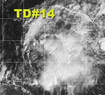
Tropical Depression 14 is still in the Caribbean moving toward the Caymans, it will have a little bit of opportunity to strengthen, but not much. I think it will become marko, but avoid "landfall" on Florida and move over the bahamas as a minimal tropical storm. it then will race off to the Northeast to make way for the front that will finally cool us down here.
Hurricane Season isn't quite over, but the bulk of it was around the time of Isidore, Kile, and Lili. Things will be quieter here from now on. If another storm does develop we will post for sure. Keep watching, when you take your eye off is when the storm may approach.
NRL Monterey Marine Meteorology Division Forecast Track of Active Systems (Good Forecast Track Graphic and Satellite Photos)
NASA GHCC Interactive Satellite images at:
North Atlantic Visible (Daytime Only), Infrared, Water Vapor
Some forecast models:
NGM, AVN, MRF, ETA ECMWF
DoD Weather Models (NOGAPS, AVN, MRF)
AVN, ECMWF, GFDL, MM5, NOGAPS, UKMET
Multi-model plots from WREL
Other commentary at Mike Anderson's East Coast Tropical Weather Center, Robert Lightbown/Crown Weather Tropical Update Accuweather's Joe Bastardi, Hurricane City Weather Audio Broadcast Network - Live Audio from Jim Williams and Barometer Bob , mpittweather , Tropical Weather Watchers.Com (JasonM) Gary Gray's Millennium Weather, Barometer Bob's Hurricane Hollow, Snonut, Ed Dunham and Jason M in our Storm Forum Even more on the links page.
- [mac]
| Brett |
| (Weather Watcher) |
| Tue Oct 15 2002 03:25 PM |
|
|
Well, honestly, I had written this one off. Wasn't even going to pay any more attention to it. It remains sheared, shear is supposed to increase further, and all models take it rapidly northeast. However, the 11 a.m. discussion surprised me. There is some indication now that (i forget who) someone's earlier idea that this thing gets left behind in the NW Carrib. may come to fruition. This is a very slim possibility to me...and I am stll convinced it is going to head NE, or even ENE, probably get to minimal TS status, and head through the southern Bahamas out into the sea. Still, the NHC seems to at least be considering the possibility....
Man, some of these babies have very unpredictablethis year huh? The models were all in agreement this would be near Havana by now.
Brett
| tom5r |
| (Weather Watcher) |
| Tue Oct 15 2002 03:30 PM |
|
|
Monroe County (keys) has discontinued the tropical storm watch. Guess nothing's gonna happen here.
| Unregistered User |
| (Unregistered) |
| Tue Oct 15 2002 04:00 PM |
|
|
Hey, look at 40 north, 52 west...tell me that is not a tropical or subtropical storm!
IHS,
Bill
| HanKFranK |
| (User) |
| Tue Oct 15 2002 08:36 PM |

|
|
|
bill, the system you speak of drifting out into the north atlantic.. that's kyle. it still has vague tropical characteristics, but more extratropical than anything else.
td 14.. pressure has dropped a bit, flight level winds slightly higher. nhc likes to play conservative, so doubt it will get the upgrade at 5. still should be marco, but probably never be substantive or threaten anywhere aside from cuba and the bahamas.
extratropical low cranking up in the southeast, going to move up the coast tomorrow. stormy weather on the way from the carolinas to new england.
HF 2035z15october
|
Ed Dunham
|
| (Former Meteorologist & CFHC Forum Moderator (Ed Passed Away on May 14, 2017)) |
| Tue Oct 15 2002 11:45 PM |
|
|
Center is getting very difficult to locate and at 2230Z it may have reformed northward again near 20N 82.5W. Pressure drops may be associated more with the approaching trough rather than a developing cyclone. Circulation is becoming ragged and may be in the process of being absorbed by the general circulation associated with the north Gulf cyclone. Recent burst of convection north of what may be the reforming center might keep the TD alive as a distinct entity for another day - but it has to persist and enlarge overnight or the recognition of TD 14 might be short-lived. If it holds together long enough, extreme south Florida might get a brush. If the center continues to jump northward, its unlikely that the system could ever make TS status.
Cheers,
ED
| LoisCane |
| (Veteran Storm Chaser) |
| Wed Oct 16 2002 05:11 AM |

|
|
|
There was a lot of speculation in Miami yesterday that if the TD did not become picked up by the front that it could become sheared apart and not survive.
In NY tonight watching from a distance. You site is a real life saver...easy to use and find info fast and really appreciate it and all your work and everyone's input.
thanks..
also...thanks to SNONUT site that has everything a girl could use.. WV, IR and water temps.. Of course my son has these big speakers on his computer and the hurricane sound scared me..freaked and said real loud WHATS THAT and they looked at me and said.. that site you're on..
Was cute.. either way, thanks for helping me stay up to date on the TD...
| Unregistered User |
| (Unregistered) |
| Wed Oct 16 2002 01:52 PM |
|
|
Has the TD go NE into the Central Bahamas, then put on the brakes, then head NW towards Grand Bahama Island at 120 as a 40 knot storm!!!! Strange. Must go with it getting completely cut off from the trough. Thoughts?? Any other models show this?? Cheers! Steve H.
| Unregistered User |
| (Unregistered) |
| Wed Oct 16 2002 02:10 PM |
|
|
Water vaper loops show a stubborn ridge to the ESE of the Bahamas trying to rebuild as the trough lifts out to the NE. Models are showing some hanging back of TD #14 as the ridge tries to pinch off the TD from the SW'erlies. NGM and even AVN give the TD a studder step trying to escape NE, NGM has the another low beheind the TD south O' Cuba. hmm. Cheers!!
| HanKFranK |
| (User) |
| Wed Oct 16 2002 03:10 PM |
|
|
|
|
think that run is just gfdl garbage.. the t.d. most probably continues NE. ridging would have to really resurge to block 14, highly doubtful.
as for the model shown trailer.. yeah, that could be interesting. there is still a upper environment in the sw caribbean that could foster organization in the wake, with convection still scattered in the sw caribbean. negative mjo (the happy version) is creeping back into the picture.. activity somewhat likely next week.
former kyle system in the central atlantic dropping SE-ward. be funny if it manages to cut off and redevelop.
HF 1507z16october
| Unregistered User |
| (Unregistered) |
| Fri Oct 18 2002 01:16 AM |
|
|
96L has been posted on the NRL site at 9.6N/44.3W moving west at 10. Not much to say about it, and kinda question why they put it up at this point. It's on the east side of a trough/ULL that is expected to move (as a mid/upper-level low)to the SSW into northern Venezuela, and camp there for a coupla days. since the low may cut off it could move in tandem with 96L and pull the SW shear along with it. If/When 96L moves WNW, it may get enhanced by the low if it moves further south into Venezuela. On the other hand, the shear may just shread up 96L and take it off the chart, or it could wait until entering the central Caribbean before attempting any kind of development. Something to watch though. Maybe this could be the wave that brings a system into the NW Carib down the road. Hey! Does anyone know where to get the Numerical models on INVESTs?? I lost my link. A link would be appreciated. Thanks. Cheers!!
| garyb |
| (Weather Guru) |
| Fri Oct 18 2002 11:11 AM |
|
|
Steve this should help. NWS FTP server. Gary ftp://ftp.nhc.noaa.gov/pub/products/nhc/model/
| Unregistered User |
| (Unregistered) |
| Fri Oct 18 2002 11:41 AM |
|
|
Thanks Gary!!!
| Kevin |
| (Weather Master) |
| Fri Oct 18 2002 08:34 PM |

|
|
|
Our trip up to NC was beautiful, there was one day (Wednesday) that was rainy and cold but the rest of the days were sunny and cool. I had a good time on this *heavily* needed vacation.
Concerning TD14...you know I am the type that will come out and admit when I am wrong right away. I busted *BIG TIME* with this storm. I thought this would become a minimal cane and affect S. Florida and that was really off the mark. The problem? Deep convection never developed on top of the LLC. That's not a good recipe for development at all.
As for the SW Caribbean producing another storm, I'm not buying it at this time. There is very little model support at this time for anything popping down there. I want to see an LLC with deep convection associated with it before saying anything about development. Chance of development: 0/10, after all, there is only popcorn thunderstorms north of Panama. A feature such as a well-defined tropical wave would help to develop something. 96L may be the only hope for this.
Also, has anyone noticed how quiet the E. Pac has been...we've only gotten to the I-storm (I think) and there is nothing in the forseeable future. Interesting.
That's all for now.
Kevin
| Unregistered User |
| (Unregistered) |
| Sat Oct 19 2002 04:13 PM |
|
|
East of the Bahamas...a low level vortex with some convection firing, first area of interest.
In the Yucatan Channel, some convection firing, not organized.
The system east of the Bahamas is...interesting.
It aint over till it's over, month and a half to go....
IHS,
Bill
| Unregistered User |
| (Unregistered) |
| Sun Oct 20 2002 11:26 PM |
|
|
think it might be, bill. been a very quiet october, and nowhere in the basin does development look very likely. ssts off south america are quite warm now.. think el niño has stamped down on atlantic basin tropical activity for the season. outside of maybe another pattern development system.. think 2002 is done. based on el niño's usual endurance, i dare say next year will finally be a below-average one.
2002 season prediction, same since november 2001:
12-8-4
current season tally:
12-4-2
hurricane numbers well off, but the NS totals werent bad.
i'll have something for next year around november 15th.
HF 2324z20october
| troy2 |
| (Storm Tracker) |
| Mon Oct 21 2002 03:50 PM |
|
|
interesting litle 'blob' just off s florida.
the convection has waned since the system is over land more. but looked to have some rotation
| Unregistered User |
| (Unregistered) |
| Tue Oct 22 2002 11:45 AM |
|
|
Is looking very good on early vis pix. Shear forecast is for improving conditions in the Caribbean with light shear conditions over the next few days. I actually find tht hard to believe looking at the sat pix, but if it eases up we could have something to watch in the eastern Caribbean later this week. Time and westerlies are working against the season now. WIll a pattern change occur, even temporarily, that could allow a window of development?? Not sure; I just keep thinking about Olga last year. Maybe we're closing the book too soon? Different pattern out there now though. I'm watching the wave for now. Cheers!!
| 57497479 |
| (Weather Master) |
| Wed Oct 23 2002 09:59 AM |

|
|
|
Things have been quite lately, Can't really say if we will have any development in the next few weeks or not. As you said maybe we may have something to watch but I don't think that it's going to be anything to get very excited about. Looks at this point that most of the activity will stay well south of us, possibly some low pressure that may head in the direction of the North Central Gulf latter in the month. looks like at this point the most potiental area for development will be the Eastern Atlantic as a fish spinner.
Never the less I am sure that most if us could use at least one more tropical system this season before it shuts down, sorta like one more cup of coffee. This season has suprised a lot of people so who knows how it will end.
Toni
| Unregistered User |
| (Unregistered) |
| Thu Oct 24 2002 02:37 AM |
|
|
kenna and lowell in the eastpac.. kenna set to recurve into mexico this weekend around cabo corriente or mazatlan. might rev up into something mean, structurally looks good. rain from it ought to be up here in the southeast early next week. how 'bout them halos?
HF 0233z24october
| Unregistered User |
| (Unregistered) |
| Thu Oct 24 2002 11:42 AM |
|
|
I am thinkin' like I was earlier this week, that some Caribbean development is possible during the next few days, as there is a disturbance in the E. Carib, and an area also off the NW coast of Columbia. Shear is backing off but still there. pattern of EPAC activity leads me to believe we'll see some here in the Atlantic basin (Caribbean) for the next 2 weeks. The Canadian is the most emphatic I've seen so far today, and brings a TD/TS moving westward near Jamaica at 120 hours. NOGAPS still showing some development, although it's almost looking like it has two areas trying to get going, but struggling (shear/westerlies??) or working off each other. Somehow I think we'll see a named system out of this by early next week. Watching the models trends and Pix!! Cheers!!
| HanKFranK |
| (User) |
| Thu Oct 24 2002 05:59 PM |
|
|
|
|
mjo negative phase is here, so says the daily graphic. as you'd expect, a couple of suspect areas in the caribbean, though no invest as of yet. since eastpac activity started around the 21st, i'd say caribbean activity is imminent.. if the mjo movement delay is its usual few days behind in the atlantic.
kenna a category four. presentation not as good as earlier, probably eyewall contractions. going to hammer the area near cabo corrientes early saturday, and probably be up in southeast texas late sunday/early monday. if enough of a low survives, possibly have a depression or weak storm moving northeast near the texas coast. definitely a lot of rain on the way.
another noreaster type storm set to form near the bahamas next couple of days as well. probably some hybrid features.
this is probably the last gasp of the season. as steve said, maybe a storm or two to go.
HF 1755z24october
| Kevin |
| (Weather Master) |
| Thu Oct 24 2002 09:24 PM |
|
|
|
|
Kenna is amazingly impressive! I can barely think of a word for this type of event, latest recon shows pressures down to 918 millibars. I think 916 is a category 5, so another pressure drop may do the job. What is even more impressive is that this IS NOT because of El Nino. This is simply due to a tropical disturbance in the right place at the right time. A negative MJO, a tropical disturbance, and a ridge right over the disturbance can lead to something big very quickly. Mexican Coast will be war zone...if Kenna doesn't level off too much before landfall damage will be similar to what Gilbert did to the Yucatan in 1988. Horrific.
There has been a lot of fanfare concerning Caribbean development in the next 2-5 days, and I think it may be valid. There is currently some pretty strong, disorganized convection north of Panama. There is also numerous amounts of energy along 10N moving into the area. This combined with the MJO negative moving in should lead to some development in this area in 3-4 days. Also, I'll betcha anything that Kenna is teleconnecting to any storm that develops in the Caribbean will have a NE curve eventually. I'm not going any further than that.
Kevin
| Kevin |
| (Weather Master) |
| Thu Oct 24 2002 09:32 PM |
|
|
|
|
160 mph as of 2 PM Pacific time!
| Kevin |
| (Weather Master) |
| Thu Oct 24 2002 10:31 PM |
|
|
|
|
5:30 PM TWO mentiones SW Caribbean and WI wave. Thinking that two may ultimately jump start each other.
http://www.nhc.noaa.gov/text/MIATWWOAT.html
| Unregistered User |
| (Unregistered) |
| Fri Oct 25 2002 12:15 AM |
|
|
What is MJO?
| troy2 |
| (Storm Tracker) |
| Fri Oct 25 2002 01:08 AM |
|
|
the current forecast on the NRL site shows a swing of Kenna into S texas. What are the chances of that baby hitting the gulf? Just HYPotheticaly speculating of course.
Man, the surfers in SoCal have to loving this.
| troy2 |
| (Storm Tracker) |
| Fri Oct 25 2002 01:20 AM |
|
|
Shawn may get his storm yet. Sneaking up from behind.
That Kenna is a beauty. Sucks such a storm while beautiful to look at will mess up so many peoples day.
One model albeit its the latest gfdl has it holding itself together in a limited capacity and finally reemerging off the NC coast in 4 days or so.
| 57497479 |
| (Weather Master) |
| Fri Oct 25 2002 09:46 AM |
|
|
|
|
WOW! Could get interesting for the next few weeks. Things are starting to fire up again, and Kenna is a beautiful looking storm yet so very dangerous. If I lived in Mexico right now I think I would be headed out of town.
Goes to show you just when I thought the season was going to quitely fizzle out we get this sudden burst. From what I am seeing on the long range models the area from Africa to the Caribbean looks like it will stay quite disturbed for the next few weeks. At least we have something to focus on.
It will be interesting to see how much of an impact Kenna will have on the lower 48.
Toni