danielw
|
| (Moderator) |
| Wed Sep 29 2004 09:41 PM |

|
|
|
Jeanne's remnants were located about 200 miles east of New York City,NY at 11:00AM EDT on September 29, 2004.
Maximum sustained winds re 25mph with higher gusts.
The remnants of Jeanne are moving E at 30mph, and forecast to move ENE over the Atlantic.
Damage along the coast from storm surge was greater this time than in Frances, including our place in New Smyrna Beach which lost the beach walkway and about 8 feet of concrete walkway behind the seawall.
Lisa is located, at 5PM EDT-Wednesday, 1180 WSW of the Azores Islands. Moving N at 12mph. Maximum sustained winds are 70mph. Lisa is forecast to be absorbed by the remnants of Jeanne.
Lisa is already destined to be a fish spinner... so that leaves us with...
NOTHING! Hold a party... no storms currently. The season isn't over yet, but there is no discernable storm threats in the forseeable future.
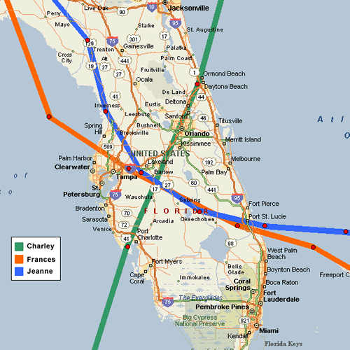
Skeetobite shows the paths of all three central Florida storms...

Event Related Links
You can find links to County Emergency Management offices at floridadisaster.org
Jeanne Color Satellite
Various Audio/Video Feeds from hurricane affected areas
Hurricane Local Statements for Weather Offices in:
All Current Hurricane Local Statements
Mark Sudduth is doing video updates as he heads toward Vero to set up his reasearch team. Check on it here.
Hurricanetrack HIRT vehicle (camera, and more)
Jeanne Models -- This image animated over time
Karl Models -- This image animated over time
Lisa Models -- This image animated over time
Jeanne Sphagehtti Model from BoatUS/Hurricane Alley
Jeanne Plots from Weather Underground
Jeanne Satelllite Image with track/radar Overlays
Jeanne Radar Image
Forecast Discussions for (Show All Locations):
Tampa. Miami, Key West, Jacksonville.
Melbourne
General Links
Skeetobite's storm track maps
Current Aircraft Recon Info (Decoded) thanks Londovir
Other Recon Info
NRL Monterey Marine Meteorology Division Forecast Track of Active Systems (Good Forecast Track Graphic and Satellite Photos)
Check the Storm Forum from time to time for comments on any new developing system.
Follow worldwide SST evolution here:
Global SST Animation
NASA GHCC Interactive Satellite images at:
North Atlantic Visible (Daytime Only), Infrared, Water Vapor
LSU Sat images
RAMSDIS Satellite Images (high speed)
Some forecast models:
NGM, AVN, MRF, ETA ECMWF
AVN, CMC,GFDL, JMA,NOGAPS,UKMET
DoD Weather Models (NOGAPS, AVN, MRF)
Multi-model plots from Mid-Atlantic Weather
Other commentary at Independentwx.com, Robert Lightbown/Crown Weather Tropical Update Accuweather's Joe Bastardi (now subcriber only unfortunately), Hurricane Alley North Atlantic Page, Hurricanetrack.com (Mark Sudduth), HurricaneVille, Cyclomax (Rich B.), Hurricane City , mpittweather , WXRisk, Gary Gray's Millennium Weather, storm2k, Barometer Bob's Hurricane Hollow, Snonut,
Even more on the links page.
|
danielw
|
| (Moderator) |
| Wed Sep 29 2004 09:59 PM |
|
|
|
|
TROPICAL WEATHER DISCUSSION
NWS TPC/NATIONAL HURRICANE CENTER MIAMI FL
805 PM EDT WED 29 SEP 2004
...DISCUSSION...
...GULF OF MEXICO...
COLD FRONT IS OVER THE CENTRAL GULF FROM ABOUT PENSACOLA SSW TO
28N90W INTO THE SW BAY OF CAMPECHE. THIS IS GENERALLY A DRY
FRONT WITH ONLY ISOLATED MODERATE IN THE SW GULF S OF 23N W OF
92W. FRONT ISN'T EXPECTED TO MAKE MUCH MORE PROGRESS DUE TO A
NE-SW ORIENTED MID/UPPER RIDGE FROM THE FLORIDA STRAITS TO THE
SW GULF. PATTERN IS SOMEWHAT STAGNANT WITH LITTLE CHANGE LIKELY.
CARIBBEAN SEA...
TSTMS KEEP FIRING IN THE SW CARIBBEAN ON THE DIVERGENT SIDE OF A BIG UPPER LOW S OF HISPANIOLA. WIDELY SCATTERED MODERATE S OF 14N W OF 79W WITH STRONG TSTMS NEAR THE COAST OF NW COLOMBIA.
DRY NE WINDS ARE OVER THE NW CARIBBEAN WITH GENERALLY QUIET WEATHER AND LOTS OF MID/UPPER SUBSIDENCE. HIGH CLOUDS OVER MOST OF THE E CARIBBEAN DUE TO TSTM BLOWOFF AND UPPER LIFT FROM THE UPPER LOW S OF HISPANIOLA ADVECTING THE MOISTURE EASTWARD TOWARD THE LESSER ANTILLES. THIS UPPER LOW IS ALSO PRODUCING LOTS OF RAIN WITH ISOLATED SHOWERS PRESENT N OF 16N E OF PUERTO RICO IN THE MOISTURE-RICH ENVIRONMENT. IN ADDITION..WIDELY SCATTERED SHOWERS ARE FROM 12N-17N BETWEEN 65W-71W. LOW WILL BE SPREADING LOCALLY HEAVY RAINS ACROSS HISPANIOLA TONIGHT INTO THE REST OF THE CENTRAL CARIBBEAN TOMORROW.
THE W CARIBBEAN MIGHT BE A PLACE TO WATCH FOR TROPICAL GENESIS WITH MODELS DEVELOPING UPPER RIDGING IN THE AREA BEHIND THE UPPER LOW MOVING THRU THE AREA OVER THE NEXT FEW DAYS.
| sthorne |
| (Weather Watcher) |
| Wed Sep 29 2004 11:14 PM |

|
|
|
Quote:
Lisa is already destined to be a fish spinner... so that leaves us with...
NOTHING! Hold a party... no storms currently. The season isn't over yet, but there is no discernable storm threats in the forseeable future.
...and there was much rejoicing (hooray!) Hurricane season is much better looked at from a distance.
Just got the phone/DSL line back today. We were without power for only 26 hours, we must be on a main line for sewer or water for Saint Lucie West. My mom in Vero has a transformer sitting in her backyard, and it's not a lovely lawn decoration. She's still out of power.
Of the refugees at our house, our friends from Fort Pierce who left thier Mobile Home lost their home, they will be staying with us while they wade through FEMA. The grandparents from Vero incurred no further damage, but they are still without power, so are staying with us. The relatives from around the corner fared well and have returned home.
1/2 of Saint Lucie County public schools are severley damaged, they have been out since Sept 2, no idea when or HOW they will open again. The private school my daughter attends suffered no significant damage and will open again when the power is restored.
That's about as quick an update as I can get in, lots to catch up on. Hope it's not a lot of repeating information.
| MrSpock |
| (Storm Tracker) |
| Wed Sep 29 2004 11:13 PM |
|
|
I just heard from richisurfs, and after losing power for a couple of days, he is back up and running, and he and his family are ok. They were to the north of the track, but they have a well-built house, and came through it fine. He wanted me to let everyone know they were ok.
Is there anyone else we haven't heard from yet?
|
danielw
|
| (Moderator) |
| Thu Sep 30 2004 05:36 AM |
|
|
|
|
It's All good news.
|
SkeetoBite
|
| (Master of Maps) |
| Thu Sep 30 2004 06:31 AM |
|
|
|
|
Having an opportunity to watch 3 hurricanes up close, I noticed a pattern with the winds that I hope can be explained.
My perception is that while the winds are moving laterally at great speed, they also appear to be blowing downward. Most of the debris is lying close to its source. For example, we have a massive oak at the edge of the golf course behind our place. This tree lost a number of branches, large and small, which are ALL lying around the base of the tree.
Many of us have seen pictures of up to three different church steeples piercing the roof of the building right next to the peak of the roof. Seemingly an impossibility if the winds where not also blowing down with close to the same force.
A casual observer would expect debris to be carried great distances away as in a tornado, but this isn�t the case. Even the pictures of catastrophic damage show the debris from damaged or destroyed structures remains near by.
Any insight you can provide for us?
| VandyBrad |
| (Weather Hobbyist) |
| Thu Sep 30 2004 07:03 AM |
|
|
|
|
I have no weather background what-so-ever but my first thought was "lift," or rather the opposite of it. We know that winds at higher altitude have higher velocity. Is it possible that these observations are a result of a lift effect working pushing the debris downwards?
|
danielw
|
| (Moderator) |
| Thu Sep 30 2004 07:05 AM |
|
|
|
|
While I haven't thought about the winds blowing downward theory, it does bear some serious thought.
I do know however that there has been research into the Hardwood species taking some of the "wind" out of hurricanes. Specifically the large friendship-type live oak trees. Many were stripped bare of their leaves in Camille and other storms here on the MS Gulf Coast. They lost a few limbs and branches, but no major damage. You may lookup Dr Chris Landsea at the Hurricane Research Division. His group has done extensive research into landfalling hurricanes, and may be of some assistance. Ricreig may be able to give you some info on Camille as he was stationed at Keesler AFB.
| MrSpock |
| (Storm Tracker) |
| Thu Sep 30 2004 07:17 AM |
|
|
http://www.srh.noaa.gov/data/PHI/PNSPHI
This disc. goes into great detail about why the forecast track of Jeanne was off by 200 miles the other day, how it interacted with mid-lattitude systems, etc. Even though the storm track was off, the correctly note that the track was still inside the cone of uncertainty, and the lesson is, focus on the cone, not the dead center of it.
| GuppieGrouper |
| (Weather Master) |
| Thu Sep 30 2004 07:29 AM |
|
|
I too noticed the phenomenon, that nothing that was already on the ground was moved. We had a lot of yard trash waiting to be picked up and it was not blown around! However, much higher up on the roof and the trees were affected greatly. I think that the strewn debris is a key to studying how to make homes and landscapes "hurricane friendly"
| Ronn |
| (User) |
| Thu Sep 30 2004 08:53 AM |

|
|
|
Quote:
I too noticed the phenomenon, that nothing that was already on the ground was moved.
Surface winds in tropical cyclones are highest slightly above the surface due to friction at the earth's surface. This is why wind speeds are usually higher over open water, as opposed to land, because land has more friction than water.
On land, the maximum wind speeds usually reach the surface in the form of gusts, not sustained winds. This usually happens during downdrafts in rain squalls, which transport the higher winds above the surface to ground level. This might explain the downward force of wind on trees and buildings.
Meso-vortices, or mini-swirls, in the eye wall of hurricanes also can bring maximum wind speeds to the surface. Just like tornadoes, these vortices bring powerful winds right to ground level. This happened in Andrew, where we discovered narrow bands of catastrophic damage right next to areas with much less extreme damage. This is common in major hurricanes.
I am located about 4 miles inland from the Gulf Coast. When Jeanne passed just to my north this past weekend, I recorded wind gusts of 65mph in my neighborhood. However, just a 4 mile trip to the coast revealed a different situation. Winds right on the water were sustained at 60mph, and gusting to 75-80mph.
During Hurricane Jeanne, most areas slightly inland from the immediate coast likely did not see sustained winds near 120mph. These winds, and even gusts above 120mph, were realized mostly in the form of downdrafts and mini-swirls. Such wind distribution over land leads to the disparate levels of damage we see in areas struck by hurricanes.
Ronn
| BillD |
| (User) |
| Thu Sep 30 2004 09:02 AM |
|
|
An updatd link for MrSpock's message above: PNSPHI.0409292003
They apparently archive the discussion each day for about a week, so don't delay reading it. Very interesting discussion.
Bill
| tpratch |
| (Moderator) |
| Thu Sep 30 2004 10:47 AM |

|
|
|
Quote:
Surface winds in tropical cyclones are highest slightly above the surface due to friction at the earth's surface. This is why wind speeds are usually higher over open water, as opposed to land, because land has more friction than water.
I don't think you mean friction.
Friction is the "force that resists the relative motion or tendency to such motion of two bodies in contact."
Wind gets slowed over land by the drag of objects on it (land, buildings, trees, et al). The resultant turbulence disrupts the "smooth" flow of the wind and causes it to dissipate energy.
Friction itself generally refers to solid objects - drag/lift refer to aerodynamic interactions.
Or else someone may have slipped crack into my Cheerios again

| VandyBrad |
| (Weather Hobbyist) |
| Thu Sep 30 2004 10:53 AM |
|
|
|
|
Quote:
I don't think you mean friction.
Friction is the "force that resists the relative motion or tendency to such motion of two bodies in contact."
Wind gets slowed over land by the drag of objects on it (land, buildings, trees, et al). The resultant turbulence disrupts the "smooth" flow of the wind and causes it to dissipate energy.
Friction itself generally refers to solid objects - drag/lift refer to aerodynamic interactions.
Or else someone may have slipped crack into my Cheerios again
I think you are correct on both accounts:
1) drag/lift are appropriate terms (I am afterall a chemical engineer), although drag could be a result of friction between the ground and molecules in the air... I guess the immediate difference is that friction dissipates the energy via heat loss while drag generates turbulence as you mentioned. This turbulence would become evident as mini-vortices like was mentioned previously!
2) someone did indeed slip crack into your Cheerios.
| LI Phil |
| (User) |
| Thu Sep 30 2004 10:58 AM |

|
|
|
The much needed break continues...
The tropics are quiet and look to be so through the weekend...thank you!
Do need to watch for some home brew but it seems the much needed break will last a few more days at least!
Cheers
LI Phil
| Ed in Va |
| (Weather Master) |
| Thu Sep 30 2004 11:03 AM |
|
|
Looks like it was a "Perect Front/Boundary/Dry Slot"! Wonder if anyone will make a book out of it.
| Terri |
| (Weather Watcher) |
| Thu Sep 30 2004 11:18 AM |

|
|
|
Quote:
An updatd link for MrSpock's message above: PNSPHI.0409292003
They apparently archive the discussion each day for about a week, so don't delay reading it. Very interesting discussion.
Bill
Thank you, Bill and MrSpock.That is very interesting discussion, indeed! Seven inches of rain??? I was very fortunate on the GA coast. My rain was minuscule compared to those amounts.
| tpratch |
| (Moderator) |
| Thu Sep 30 2004 11:29 AM |
|
|
|
|
Quote:
The much needed break continues...
The tropics are quiet and look to be so through the weekend...thank you!
Do need to watch for some home brew but it seems the much needed break will last a few more days at least!
Cheers
LI Phil
I've been trying to rebuild my engine with a friend for 2 months now. Each and every weekend starting with Charley, hurricane-related activities have taken precedence. This Sunday? First time since Charley that he and I will be able to port the housings before getting them lapped. After that, we still have to assemble them.
$20 says that the last steps will be interrupted by a Hurricane (that's 2-3 weekends off).

| Ronn |
| (User) |
| Thu Sep 30 2004 11:29 AM |
|
|
|
|
Quote:
1) drag/lift are appropriate terms (I am afterall a chemical engineer), although drag could be a result of friction between the ground and molecules in the air... I guess the immediate difference is that friction dissipates the energy via heat loss while drag generates turbulence as you mentioned.
Actually, frictional drag is probably the most appropriate term.
Essentially, what I was trying to say is that the greater friction over land slows the wind speed down. However, the higher wind speeds above the surface (where there is less friction) are brought down to the surface via downdrafts. Additionally, the meso-vortices I am talking about are not the result of drag, but moreso from eyewall dynamics. I am not an atmospheric scientist, so I very well may be incorrect. Here are some links.Winds Near the Surface
Meso-Vortices in Bertha
God Bless,
Ronn
| MrSpock |
| (Storm Tracker) |
| Thu Sep 30 2004 11:52 AM |
|
|
Thanks for updating that, I was unaware of the archiving.
| tpratch |
| (Moderator) |
| Thu Sep 30 2004 11:56 AM |
|
|
|
|
I still don't like hearing friction as relating to the interaction between wind and land.
Call me old-fashioned, but...
| MrSpock |
| (Storm Tracker) |
| Thu Sep 30 2004 11:54 AM |
|
|
I am sure there will be papers written. The unusual events are the ones you can really learn from, and this same thing happened with Floyd, so it has happened here before.
As it turns out, the center actually passed very close to my location, but fortunately, I did not receive the severe weather.
| Bloodstar |
| (Moderator) |
| Thu Sep 30 2004 02:07 PM |

|
|
|
While there's no organization at the surface, I'm noticing
the outflow of the storm seemes to be easterly on the
northern side and westerly on the southern side. Would this be a possible precursor to some organization developing?
Thoughts?
Mark
(Blissfully listening to Kittie)
| ShanaTX |
| (Storm Tracker) |
| Thu Sep 30 2004 02:38 PM |
|
|
I saw some of those steeple pics and thought something was odd about them...
It's difficult for those of us outside hurricane areas to visualize what is going on = I thought it was like a big wind blowing stuff around.
Downdraft... interesting. I have seen the results here... looks odd with telephone poles all snapped at the same height and the broken off parts lying all in a row. That debris didn't go far either. Signs in the road, trees and limbs pretty much just toppled over. I was driving at the time and thought 'tornado'! especially when we got hit with a massive amount of hail, but I was kinda busy dodging fallen electric lines to think about the fact that debris was close to where it started from...
hmm...
'shana
| Keith234 |
| (Storm Chaser) |
| Thu Sep 30 2004 02:59 PM |

|
|
|
I believe drag is the result of friction, everything on Earth and any other bodies have friction. Friction from water molecules and air molecules is very minute but should be considered, it is mainly land and the obstructions that lie on top of it. Downbursts don't take down the wind from the upper atmosphere, they create it. A good example of a meso-vortice, take a cup spin it around with a spoon then move the spoon the other way quickly. You can see little meso-vortices, meso is simply a term that describes the size of the weather. But your right frictional drag makes vortices in the eye.
| Unregistered User |
| (Unregistered) |
| Thu Sep 30 2004 03:28 PM |
|
|
Looking @ the Water Vapor Loop.......Seems to be some "spin" to the clouds due S of Hati.. There Also seems to be some storms building on the SE side of the circulation.
Making too much out of nothing?
I ask the experts.....
Thanks
Matt
| Keith234 |
| (Storm Chaser) |
| Thu Sep 30 2004 03:37 PM |
|
|
|
|
That one is facing some SW shear for the moment and has good outflow to the north and east because of the ULL to the NW backing in. It's moving in the direction of Hati and that might have some effect on it. That wave has become very compact east of the Leewards, but still no banding features visible on satellite imagery. Neverless should be watched ravenously as storms in spetmember are capable of becoming very strong.
| Keith234 |
| (Storm Chaser) |
| Thu Sep 30 2004 03:44 PM |
|
|
|
|
That weak stalled cold front has stalled out in the area that I like to call the "Gulf of the Yuctan." The system has is starting to make the change from a weak barolclinic system to more of a tropical system, like the Catrina off the Brazilian coast, only no rex block or blocking pattern yet. This should also be watched, looks like these quiet time periods are always short lived, sigh.
| LI Phil |
| (User) |
| Thu Sep 30 2004 03:59 PM |
|
|
|
|
WV Loop
This bears watching (uh oh...bear watch!), but any development would be slow to occur, but there is a mid/ upper level low present. The other area of convection to the east of the leewards may also need to be watched closely.
WV Loop 2
The convection in the Bay of Campeche (BOC) could pose a problem down the road...right now just need's monitoring, but could lead to some home brew in a couple of days.
Although the african wave train is still active, conditions are not that favorable for any further CV longtrackers...I think we are close to officially declaring the CV season over...
| Unregistered User |
| (Unregistered) |
| Thu Sep 30 2004 04:02 PM |
|
|
There seem to be quite a little batch of storms SW of Tampa (last 2 / 3 frames) Think we will see rain today/tommorow?
As always, Thank You
Matt
| Unregistered User |
| (Unregistered) |
| Thu Sep 30 2004 04:07 PM |
|
|
Looks like the "center" is moving NW towards Jamacia? Is that an "eye" forming @ its center?
| leetdan |
| (Weather Guru) |
| Thu Sep 30 2004 04:14 PM |

|
|
|
Hmm, Lisa has never looked better circulation-wise, but now there's hardly any convection left.
As for the Haiti storm, nogaps at least indicates it's there but slides it west into the Pacific without any development. From the WV loop it looks like it's trying to keep the convection centered as hard as it can, but other than some rotation it's otherwise not very well organized.
As for 10n53w, the models don't even see this one. From what I've watched, I see this thing following a track farther south than Earl, drenching the coast of South America but otherwise not developing.
For the record, I have no idea what I'm talking about.
| LI Phil |
| (User) |
| Thu Sep 30 2004 04:21 PM |
|
|
|
|
TWD pretty much says it all...
| WXMAN RICHIE |
| (Weather Master) |
| Thu Sep 30 2004 04:40 PM |

|
|
|
Holy ****
Hurricane Mathew
Yikes
http://www.kn4lf.com/matthewloop.gif
| Unregistered User |
| (Unregistered) |
| Thu Sep 30 2004 04:51 PM |
|
|
Why does it have to be Matthew?
Cant we just skip Matthew?
I really really don't want a Hurricane with my name...
| leetdan |
| (Weather Guru) |
| Thu Sep 30 2004 04:53 PM |
|
|
|
|
*bookmarks*
Thanks!
| LI Phil |
| (User) |
| Thu Sep 30 2004 05:09 PM |
|
|
|
|
Quote:
Why does it have to be Matthew?
Cant we just skip Matthew?
I really really don't want a Hurricane with my name...
Conjures up a certain mentally deficient poster from a couple of years back too...
| SteveieB |
| (Weather Watcher) |
| Thu Sep 30 2004 05:32 PM |
|
|
http://www.srh.noaa.gov/mlb/jeanne/jeanne_swath
Here is the wind swath for Jeanne from MLB weaher office, kinda shows what that friction/drag stuff is doing.
| James88 |
| (Weather Master) |
| Thu Sep 30 2004 05:31 PM |

|
|
|
Thanks for the link!
| matlon |
| (Registered User) |
| Thu Sep 30 2004 05:36 PM |
|
|
Agreed, if there is to be a Matthew(also my given name) this year, and we all know there will be, please let it be a fish spinner or hit an unpopulated area of the Mexican coast. And to think that I did the Scripture readings at Sunday morning mass with my friend Lisa this past week, that was a little weird.
| Unregistered User |
| (Unregistered) |
| Thu Sep 30 2004 05:34 PM |
|
|
Could someone point me to a place where I can find my exact Latitude and Longatude?
Thanks
| LI Phil |
| (User) |
| Thu Sep 30 2004 06:03 PM |
|
|
|
|
http://stuff.mit.edu/cgi/geo
http://www.wunderground.com/tropical/
enter your city and state and that's it!
For the wunderground, just enter your zip code
| HanKFranK |
| (User) |
| Thu Sep 30 2004 06:12 PM |

|
|
|
if hurricane monitoring were like the national terror alert status, that's where we'd be. nothing active aside from a distant fish spinner, and that may or may not change over the weekend.
lisa is heading out and away. it's finally beaten shear only to enter a dry enough environment and cooling ssts that have let it's convection deteriorate. still showing flashes of will to develop, and it may become a low-rung hurricane over the next day before turning northeast and emptying the basin.
before lisa gets out of the pool the chances of either of the other concern areas developing aren't very significant.. but worth mentioning.
first is a weak wave near 52w which isn't acting so weak anymore.. in fact it has been throwing more convection over the last couple of days. upper winds are mediocre as it is beneath the base of a broad upper trough, and it is at low latitude and has little amplitude... convergence seems to be resultant of faster easterlies rather than backing in the deep tropics.. nonetheless it has the opportunity to slowly organize as it gets closer to the caribbean and into a more favorable environment. it shouldn't develop tomorrow, but may become a tracked invest or something more over the weekend.
to the west a tropical wave and strong convection near the colombian coast are interacting with a weakening upper low in the southwestern caribbean.. the amplitude of the system has increased as the divergence east of the upper low is enhancing convection. as the upper low reorients the support for strong convection should become greatest midway between jamaica and panama tomorrow.. and over the weekend the low pressure shown in the region may begin to organize. gfs continues to develop a weak, broad low in the area and migrate it up towards the yucatan next week. there should be enough ridging to keep it moving wnw or nw over the next five days, should anything start to consolidate. i do expect an invest in the area at the least, by monday.
basin conditions are as such: persisting SOI positive keeping an NAO mostly positive, progressive/trough splitting pattern active, with low to medium amplitude weather systems in the mid latitudes. the potential for hybrid activity of the east coast continues, and warm caribbean and western gulf waters leave the potential for retrograding upper features to trigger disturbances on their trailing flank, when low level energy is available. the cape verde season is closing out, though waves that make it west of the sharp upper trough off NW africa with any amplitude may still try to develop further west.
what we're waiting for right now is a negative SOI shot to cause some backing in the deep tropics, and cause an october storm in the western caribbean.
HF 2207z30september
| BeachBum |
| (Weather Watcher) |
| Thu Sep 30 2004 07:33 PM |

|
|
|
If you need greater precision, you can enter your street address into DeLorme's Street Atlas USA and it will both pinpoint your location and give your LAT/LONG.
| Keith234 |
| (Storm Chaser) |
| Thu Sep 30 2004 07:39 PM |
|
|
|
|
Nope, that's just an exposed LLC (low level circulation). This wave might sneak it's way into the GOM and then surprise us all. The other wave is really getting it's act together. Looks like the hurricane season will end with a bang in the Gulf States this year, while the first frost is going on.
| LI Phil |
| (User) |
| Thu Sep 30 2004 08:01 PM |
|
|
|
|
A bonus point question has been posted in the Everything & Nothing forum...
|
danielw
|
| (Moderator) |
| Thu Sep 30 2004 09:29 PM |
|
|
|
|
TROPICAL WEATHER DISCUSSION
NWS TPC/NATIONAL HURRICANE CENTER MIAMI FL
805 PM EDT THU 30 SEP 2004
...DISCUSSION...edited for length-danielw
GULF OF MEXICO AND ATLANTIC OCEAN W OF 65W...
STATIONARY FRONT IS DISSIPATING OVER THE N GULF FROM THE FLORIDA PANHANDLE INTO THE GULF A COUPLE HUNDRED MILES S OF LAFAYETTE LOUISIANA. TROUGH FROM THIS FRONT REMAINS IN THE BAY OF CAMPECHE WITH ISOLATED MODERATE WITHIN 60 NM OF AXIS FROM 20N96W TO 25N91W. MID/UPPER RIDGING REMAINS FROM THE SW GULF INTO THE FLORIDA PENINSULA IN A NEARLY STATIONARY PATTERN. SUMMER SHOWERS ARE LIMITED TO FLORIDA TODAY WITH RATHER DRY SURFACE AIR OVER MOST OF THE GULF COAST STATES.
CARIBBEAN SEA...
LARGE MID/UPPER LOW NEAR 16N76W IS THE MAIN STORY WITH SCATTERED TSTMS ON THE E SIDE OF THE SYSTEM FROM HISPANIOLA TO S AMERICA FROM 70W-75W. LOW IS MOVING W 15 KT WITH EVIDENCE THAT TROUGHING HAS DEVELOPED AT THE SURFACE ALONG 74W IN THE CARIBBEAN. THIS IS THE MAIN AREA TO WATCH FOR ANY TROPICAL DEVELOPMENT MOVING WESTWARD... LEAVING AT LEAST A MARGINALLY FAVORABLE ENVIRONMENT FOR DEVELOPMENT ON ITS E SIDE WITH RIDGING FORMING IN ITS WAKE. SURFACE PRESSURES ARE FAIRLY LOW WITH ARUBA REPORTING 1008 MB THIS AFTERNOON. ISOLATED HEAVY RAINS ARE POSSIBLE OVER HISPANIOLA TONIGHT INTO TOMORROW. W OF THE LOW.... GENERALLY DRY CONDITIONS ARE PRESENT WITH MODERATE SUBSIDENCE OVER THE OCEAN. FARTHER INLAND.. DEEP-LAYERED MOISTURE IS HIGHER OVER CENTRAL AMERICA WITH A MORE TYPICAL SCATTERED TSTM DAY THERE.
http://www.nhc.noaa.gov/text/MIATWDAT.shtml?
| GuppieGrouper |
| (Weather Master) |
| Thu Sep 30 2004 10:17 PM |
|
|
Sounds like more gray hairs for Florida and the GOM'ers
| Staggy |
| (Verified CFHC User) |
| Thu Sep 30 2004 11:19 PM |

|
|
|
Dr. William Gray has released his "Forecast Of Atlantic Hurricane Activity For October 2004 And Seasonal Update Through September"
The entire report can be viewed here.
His forecast for October is:
Named Storms: 3
Named Storm Days: 12
Hurricanes: 2
Hurricane Days: 8
Intense Hurricanes: 0
Intense Hurricane Days: 0
Net Tropical Cyclone Activity: 20
In the section called "Florida's Future Hurricane Seasons" he says:
Floridians should view this year's onslaught of hurricane activity as a rare anomaly. This year's landfalling hurricane activity does not by itself represent the beginning or the end of any cycle or trend for landfalling hurricanes. This year will have no bearing on what will occur in future years anymore than the great paucity of Florida landfalling major hurricanes between 1966-2003 had any bearing on this year's landfalling systems. The probability of having hurricane-spawned winds, rain, and storm surge at any spot in any year along the U.S. coastline is very low. We would not recommend that anyone move out of Florida or decide not to move to Florida solely because of the threat of hurricanes. Florida hurricanes must be accepted as one small negative of an otherwise pleasant climate.
| sthorne |
| (Weather Watcher) |
| Thu Sep 30 2004 11:30 PM |
|
|
|
|
Quote:
Floridians should view this year's onslaught of hurricane activity as a rare anomaly....We would not recommend that anyone move out of Florida or decide not to move to Florida solely because of the threat of hurricanes. Florida hurricanes must be accepted as one small negative of an otherwise pleasant climate.
I certainly hope it's an anomaly, the Treasure Coast is looking like the Wind Whipped Sand Covered Coast. I do have to wonder if we are entering a 50 year period where Florida will see more landfalls.
I do have to admit, I'd be OK if a few less people moved down here
 Of course, my mother's side of the family has been dealing with Florida Hurricanes for six generations, and most of thier desendants are still here, so there must be a lot to like.
| gailwarning |
| (Weather Watcher) |
| Thu Sep 30 2004 11:33 PM |

|
|
|
While things are quiet, I want to thank you for providing such a valuable service and working so hard to give us your insight. Sometimes it was comforting, sometimes not, but it's better knowing than not.
I've been in NH for several months but am returning to one of the rings of this year's bullseye, Satellite Beach, next week. Our house fared well, and I'm feeling very fortunate.
I will be doing whatever I can to increase our home's hurricane resistance even further. How weird am I? The fact that our home has a hip roof was a key deciding factor in our purchase.
In a small attempt to contribute here, this is a very useful booklet on the subject I found today:
http://www.ibhs.org/natural_disasters/downloads/hurricane10.pdf
| recmod |
| (Weather Guru) |
| Thu Sep 30 2004 11:38 PM |

|
|
|
Take a look at this GFS Loop....
Something is starting to show up as a NW Caribbean system, moving into the Gulf and eventually over ..... gulp....
 Florida...
Of course looong range model projections have a lot of uncertanties. We just need to remain vigilant in Florida.
--Lou
|
danielw
|
| (Moderator) |
| Thu Sep 30 2004 11:49 PM |
|
|
|
|
Here's a much longer animation. The system actually moves into the GOM and westward toward Tamipco, MX, toward the end of the loop.
http://www.arl.noaa.gov/ready-bin/animation.pl?id=GFS&mdl=gfsx&file=tpptmslp
The models, linked below, haven't updated yet. The new models will have 01OCT04 00Z on them. The 12Z models, from this morning, are Not reflecting any thing in the Carib or GOM, at the time they were issued.
http://met.psu.edu/tropical/tcgengifs/
This has the updated models on it.
http://www.nco.ncep.noaa.gov/pmb/nwprod/analysis/
| recmod |
| (Weather Guru) |
| Fri Oct 01 2004 12:04 AM |
|
|
|
|
The link I posted had the full 48 image loop...but it seems to be updating as I write this.
I don't know why the loop Daniel posted shows a dramatically different solution (possibly updating model runs flip-flopping????)
The loop I posted showed the system cross near the Yucatan into the Bay of Campeche before turning NE and smacking the West Central Florida coast.....of course, keep in mind this is all pure speculation regarding a system that has not yet even developed...
--Lou
|
danielw
|
| (Moderator) |
| Fri Oct 01 2004 12:30 AM |
|
|
|
|
That may have been the same loop I saw last night after the update. The loop last night, took it into the GOM and then toward the Big Bend area. If I remember correctly, it didn't give it much of a drop from Sea level. Tropical wave or depression SLPs and winds.
The link I posted above is updating. At the current time 0418Z, it only goes out for a few days. When finished it should go out to 10 days or better.
The Canadian Model on the tcgen link did well for Ivan and Jeanne. Some of the others may have too, but I remember the Canadian as being closet to the landfall area and time.
You may have other links that you prefer. These are just a few of mine. Other than the above mentioned Low S of Haiti/ Dom Rep. I don't see anything eyecatching.
As Phil said earlier,"This bears watching (uh oh...bear watch!), but any development would be slow to occur, but there is a mid/ upper level low present."
| Keith234 |
| (Storm Chaser) |
| Fri Oct 01 2004 06:48 AM |
|
|
|
|
That disturbance south of Hati, is an ULL with some of it reaching down to the surface on the Eastern Quad. Convection will once again fire up today and this will prob be a depression by 11 PM tonight. Once you start to get into October. these storms don't remain visible very long during the night, as the nights are longer indirectly cooler. Once we get our first South Indian Ocean cyclone then we can call the CV systems done, just one of my "rules."
|
danielw
|
| (Moderator) |
| Fri Oct 01 2004 07:08 AM |
|
|
|
|
TROPICAL WEATHER OUTLOOK
NWS TPC/NATIONAL HURRICANE CENTER MIAMI FL
530 AM EDT FRI OCT 01 2004- October !!
A WESTWARD-MOVING TROPICAL WAVE INTERACTING WITH AN UPPER-LEVEL LOW
CONTINUES TO PRODUCE CLOUDINESS AND SHOWERS OVER THE SOUTH CENTRAL
CARIBBEAN SEA. SOME SLOW DEVELOPMENT OF THIS SYSTEM IS POSSIBLE
ONCE IT REACHES THE NORTHWESTERN CARIBBEAN SEA IN A COUPLE OF DAYS
WHERE UPPER-LEVEL WINDS ARE EXPECTED TO BE MORE FAVORABLE.
8AM Tropical Wx Discussion doesn't give a much weight as it did last night to the wave in the Caribbean.
| Terri |
| (Weather Watcher) |
| Fri Oct 01 2004 09:40 AM |
|
|
|
|
I read a very interesting article yesterday in the NY Times about the increase in hurricane intensity and their rainfall amounts. This is projected to continue for decades. I apologize for posting this article in its entirety, but you have to be a member to get to the NYT's link. Be sure to read the original study. The link to the study (in PDF format) is found within the article.
September 30, 2004
Global Warming Is Expected to Raise Hurricane Intensity
By ANDREW C. REVKIN
Global warming is likely to produce a significant increase in the intensity and rainfall of hurricanes in coming decades, according to the most comprehensive computer analysis done so far.
By the 2080's, seas warmed by rising atmospheric concentrations of heat-trapping greenhouse gases could cause a typical hurricane to intensify about an extra half step on the five-step scale of destructive power, says the study, done on supercomputers at the Commerce Department's Geophysical Fluid Dynamics Laboratory in Princeton, N.J. And rainfall up to 60 miles from the core would be nearly 20 percent more intense.
Other computer modeling efforts have also predicted that hurricanes will grow stronger and wetter as a result of global warming. But this study is particularly significant, independent experts said, because it used half a dozen computer simulations of global climate, devised by separate groups at institutions around the world. The long-term trends it identifies are independent of the normal lulls and surges in hurricane activity that have been on display in recent decades.
The study was published online on Tuesday by The Journal of Climate and can be found at www.gfdl.noaa.gov/reference/bibliography/2004/tk0401.pdf
The new study of hurricanes and warming "is by far and away the most comprehensive effort" to assess the question using powerful computer simulations, said Dr. Kerry A. Emanuel, a hurricane expert at the Massachusetts Institute of Technology who has seen the paper but did not work on it. About the link between the warming of tropical oceans and storm intensity, he said, "This clinches the issue."
Dr. Emanuel and the study's authors cautioned that it was too soon to know whether hurricanes would form more or less frequently in a warmer world. Even as seas warm, for example, accelerating high-level winds can shred the towering cloud formations of a tropical storm.
But the authors said that even if the number of storms simply stayed the same, the increased intensity would substantially increase their potential for destruction.
Experts also said that rising sea levels caused by global warming would lead to more flooding from hurricanes - a point underlined at the United Nations this week by leaders of several small island nations, who pleaded for more attention to the potential for devastation from tidal surges.
The new study used four climate centers' mathematical approximations of the physics by which ocean heat fuels tropical storms.
With almost every combination of greenhouse-warmed oceans and atmosphere and formulas for storm dynamics, the results were the same: more powerful storms and more rainfall, said Robert Tuleya, one of the paper's two authors. He is a hurricane expert who recently retired after 31 years at the fluid dynamics laboratory and teaches at Old Dominion University in Norfolk, Va. The other author was Dr. Thomas R. Knutson of the Princeton laboratory.
Altogether, the researchers spawned around 1,300 virtual hurricanes using a more powerful version of the same supercomputer simulations that generates Commerce Department forecasts of the tracks and behavior of real hurricanes.
Dr. James B. Elsner, a hurricane expert at Florida State University who was among the first to predict the recent surge in Atlantic storm activity, said the new study was a significant step in examining the impacts of a warmer future.
But like Dr. Emanuel, he also emphasized that the extraordinary complexity of the oceans and atmosphere made any scientific progress "baby steps toward a final answer."
| LI Phil |
| (User) |
| Fri Oct 01 2004 10:27 AM |
|
|
|
|
Why am I not surprised the New York Times is pimping global warming...
(sigh)
Anyway, JB this am:
"With this pattern, everything has been pushed southwestward as far as tropical development. It's hard for me to believe that a storm won't come out of the western Caribbean and/or Gulf in this pattern. The system that is near 72 west now will be in the southern Gulf next week, and with the big high to the north, it will either be forced to wait there or be driven into Mexico. But the European 500 mb pattern certainly looks like it's ripe along with the surface map as the big high raises pressures over the Carolinas and the upper flow over the area in question becomes southeast from the western Caribbean to the western Gulf. It looks like the pattern that set off all the activity near Florida, except displaced southwest. In other words, that is where the action looks like it should go too. Again, I would be surprised if we simply left the playing field without another threat to our coast. The most interesting aspect of all this is the idea that, given the timeline, such an event would take enough time to evolve to wait until the amplification cranked in the pattern, again another similarity to Opal which sat down there for several days before the pattern amplified and took it like a rocket out of there."
Nothing imminent, but a bear watch may be needed in the future.
| tpratch |
| (Moderator) |
| Fri Oct 01 2004 10:43 AM |
|
|
|
|
Sure, there's a disclaimer that it's baby steps, however what they don't state is this:
Those computers reach that dataset based upon an increasing trend in global warming which hasn't been shown to be accurate or truthful.
It's a big "IF this, then maybe this" model. Hardly pure emperical science if you ask me

| Unregistered User |
| (Unregistered) |
| Fri Oct 01 2004 10:47 AM |
|
|
Thank You.
I live here...
28:08:45 N 082:45:25 W
| andy1tom |
| (Storm Tracker) |
| Fri Oct 01 2004 11:44 AM |

|
|
|
hello all,
been reading the posts but not posting.. still caned-out (tornadoed-out) and fussing with the insurance company. this is the best part of the discussions when no system is there and models show one developing. i love reading the imputs from our experts on this. i just have a gut feeling that before the month of october is over the gulf will produce at least one. as far as florida being hit so much this year look at the law of averages. if you average one a year and go three years without one then in the forth year get four you still average one a year. wish i could have a nite like that at the dog track....
| doug |
| (Weather Analyst) |
| Fri Oct 01 2004 12:35 PM |
|
|
I agree totally...no pressure for a while...whew!
The Globals spin something up in the bay of campeche in 144, and it is always important to watch the area near Panama.. the Western Carribean is good for one or two before all this is over.
It seems to me climatologically everything this year is skewed about two-three weeks late, so we are really about the 17th of Sept on that calender. If that's the case then the 12th-19th of October should be that mini-peak. The Altantic ridge seems to be cooperating with this theorey..lets see how it play's out.
| doug |
| (Weather Analyst) |
| Fri Oct 01 2004 12:54 PM |
|
|
earlier today someone posted that the 8am discussion made little mention of the situation in the central Carribean I just read it and actually it goes into pretty good detail of exactly what exists there. A mid level and surface 1008mb low are situated east of the ULL that is moving wsw toward Honduras..once that clears the NHC says conditions are favorable. The surface low is on land in Columbia but will come northward. Both the ULL to the west and one to the NE will provide good ventilation opportunity for something to grow there. This will be what we need to look at over the next 48 hours or so.
| WXMAN RICHIE |
| (Weather Master) |
| Fri Oct 01 2004 01:12 PM |
|
|
|
|
Here are Thomas' thoughts as of noon Friday:
I first began discussing a possible future Tropical Cyclone Matthew back on Friday September 25th, 2004. Well take a look at this satellite image at http://www.esl.lsu.edu/special_gifs/Tropics.gif . We definitely have a fledgling tropical depression ESE-S of Jamaica. The future strength and path of this
disturbance is all a matter of timing. So everyone from Brownsville, TX to Key West, FL should watch closely. Right now it looks like LA-TX has the best chance with this one but that is subject to change.
Take Care,
Thomas F. Giella
Retired Space & Atmospheric Weather Forecaster
Plant City, FL
| Ed in Va |
| (Weather Master) |
| Fri Oct 01 2004 01:26 PM |
|
|
Latest GFS takes something into NO in about a week.
http://www.arl.noaa.gov/ready-bin/animation.pl?id=GFS&mdl=gfsx&file=tpptmslp
| Unregistered User |
| (Unregistered) |
| Fri Oct 01 2004 01:59 PM |
|
|
I thought that system looked like it was getting a little attitude yesterday. Thought I was just crazy..
| cjzydeco |
| (Weather Guru) |
| Fri Oct 01 2004 02:42 PM |

|
|
|
So nice to be one the empowered ones again. Just got the juice last night around midnight. Funny time to turn on the lights!
Nice to log on and see nothing major in my immediate weather forecast. Looking at the WV loop, I definately see the overall counter-clockwise spin south of Jamaica. But it almost looks like there are two different centers of spin, the most obvious near 18n79w and a minor one near 13n75w. I assume the former is the one with the associated ULL?
| Staggy |
| (Verified CFHC User) |
| Fri Oct 01 2004 03:09 PM |
|
|
|
|
It she now Hurricane Lisa?
01/1745 UTC 37.6N 45.9W T4.0/4.0 LISA
| LI Phil |
| (User) |
| Fri Oct 01 2004 03:17 PM |
|
|
|
|
Dvorak's would say "yes". We'll know at 5:00...
I consider it important only from the "numbers" standpoint (ie my horribly wrong 14/8/3 prediction).
| Unregistered User |
| (Unregistered) |
| Fri Oct 01 2004 03:47 PM |
|
|
Doesn't look like your really that far off.
| Unregistered User |
| (Unregistered) |
| Fri Oct 01 2004 04:09 PM |
|
|
"We definitely have a fledgling tropical depression ESE-S of Jamaica."
Does anybody agree with that statement? It sure does NOT look like a depression to me, and definitely didn't at noon.
Here are Thomas' thoughts as of noon Friday:
I first began discussing a possible future Tropical Cyclone Matthew back on Friday September 25th, 2004. Well take a look at this satellite image at http://www.esl.lsu.edu/special_gifs/Tropics.gif . We definitely have a fledgling tropical depression ESE-S of Jamaica. The future strength and path of this
disturbance is all a matter of timing. So everyone from Brownsville, TX to Key West, FL should watch closely. Right now it looks like LA-TX has the best chance with this one but that is subject to change.
Take Care,
Thomas F. Giella
Retired Space & Atmospheric Weather Forecaster
Plant City, FL
| Unregistered User |
| (Unregistered) |
| Fri Oct 01 2004 04:10 PM |
|
|
oops--sorry, didn't mean to re-paste the entire quotation at the bottom of my message
| LI Phil |
| (User) |
| Fri Oct 01 2004 04:42 PM |
|
|
|
|
It's official
Hurricane Lisa
| Rabbit |
| (Weather Master) |
| Fri Oct 01 2004 04:54 PM |

|
|
|
Still think we could have 4-6 more storms to come
| LI Phil |
| (User) |
| Fri Oct 01 2004 04:56 PM |
|
|
|
|
I agree, that's why my forecast is going to bust big time...
And to think, on July 31, we were still at 0/0/0
| James88 |
| (Weather Master) |
| Fri Oct 01 2004 05:18 PM |
|
|
|
|
Yep - it's been a crazy couple of months.
| Clark |
| (Meteorologist) |
| Fri Oct 01 2004 05:28 PM |
|
|
Hate to burst everyone's bubble -- or would that be make everyone's day? -- but there's nothing going on of concern in the Caribbean Sea right now. You are seeing an upper-level low in the SW Carib. enhancing convection south of Jamaica as a result of some diffluence at upper levels. There is no low level circulation, nor is there really any turning, as evidenced in the QuikSCAT hi-resolution scatterometer winds. There are some high wind speeds, but absolutely no sign of a circulation.
Anything developing there will be 3-5 days down the line -- that upper low needs to clear out or build down to the surface, neither of which are going to happen at any fast rate, thankfully. So yes, while Jamaica and locales may see some rain and some gusty winds as a result of the convection...tropical activity isn't really likely for a few days, not there at least.
| Unregistered User |
| (Unregistered) |
| Fri Oct 01 2004 05:38 PM |
|
|
Does any of that mean that another hurricane could hit GOM, more specifically Florida???
| HanKFranK |
| (User) |
| Fri Oct 01 2004 05:40 PM |
|
|
|
|
preface is.. lisa's been upgraded to hurricane. took it a week, but a nice finale.
to restate clark's take on the situation: no, there isn't much low level turning in the sw caribbean. the support mechanism is coming into play, but there isn't much there to cause backing and cyclogenesis at low levels. story changes down the road, as a break in the ridge will exist near the yucatan/in the BOC. bastardi thinks we don't get out of this situation without something forming, my take exactly. right now globals want to take anything down there out to the north and northeast late next week... it'll either be that or what larry did last october (stall, drift south). globals no longer indicating enough ridging to push the surface system into the mexican mainland, though that's fuzzy at this point.
yes, probably a matthew; no, no system today, tomorrow, and probably not even sunday.
small point of interest is the weak swirl near 10/45. it has a little puff of convection that keeps following it... i wonder...
HF 2138z01october
| Keith234 |
| (Storm Chaser) |
| Fri Oct 01 2004 05:42 PM |
|
|
|
|
That Upper Level Low is proprogating to the west rather rapidly. I'm starting to see more ULL's then normal, is there a reason for this?
| BeachBum |
| (Weather Watcher) |
| Fri Oct 01 2004 07:19 PM |
|
|
|
|
Quote:
I live here...
28:08:45 N 082:45:25 W
According to my map, you "live" in the middle of Pinellas Avenue, just 2 blocks north of the Tarpon Diner (where I ate breakfast Monday).
Sunday night we had a terrible time finding any place serving food. Many of the people in the diner were locals without power at home.
Fortunately, we were able to get some Greek dinners on Saturday and Monday before returning to the East coast.
|
danielw
|
| (Moderator) |
| Sat Oct 02 2004 01:21 AM |
|
|
|
|
TROPICAL WEATHER OUTLOOK
NWS TPC/NATIONAL HURRICANE CENTER MIAMI FL
1030 PM EDT FRI OCT 01 2004
FOR THE NORTH ATLANTIC...CARIBBEAN SEA AND THE GULF OF MEXICO...
THE NATIONAL HURRICANE CENTER IS ISSUING ADVISORIES ON HURRICANE LISA...LOCATED OVER THE NORTH ATLANTIC OCEAN ABOUT 855 MILES WEST-NORTHWEST OF THE AZORES.
A LARGE AREA OF CLOUDINESS AND THUNDERSTORMS IS CENTERED OVER THE NORTHWESTERN CARIBBEAN SEA. SOME SLOW DEVELOPMENT OF THIS SYSTEM IS POSSIBLE DURING THE NEXT DAY OR TWO AS IT MOVES WESTWARD.
ELSEWHERE...TROPICAL STORM FORMATION IS NOT EXPECTED THROUGH SUNDAY.
FORECASTER LAWRENCE
Hurricane Lisa has been downgraded to a Tropical Storm at 11Pm AST-Friday Oct. 1.
| James88 |
| (Weather Master) |
| Sat Oct 02 2004 05:07 AM |
|
|
|
|
She's become a hurricane again. Talk about persistent.
| Unregistered User |
| (Unregistered) |
| Sat Oct 02 2004 06:38 AM |
|
|
Lisa is over 73 or below waters now. It is a hurricane...Plus it is showing no signs of weaking...I wonder if there is a chance that this could do another record for 2004?
http://vortex.plymouth.edu/sat.irE3_an.gif
| LadyStorm |
| (Weather Guru) |
| Sat Oct 02 2004 07:26 AM |

|
|
|
A LARGE AREA OF CLOUDINESS AND THUNDERSTORMS IS CENTERED OVER THE NORTHWESTERN CARIBBEAN SEA. SOME SLOW DEVELOPMENT OF THIS SYSTEM IS POSSIBLE DURING THE NEXT DAY OR TWO AS IT MOVES WESTWARD
| Terri |
| (Weather Watcher) |
| Sat Oct 02 2004 09:30 AM |
|
|
|
|
Quote:
Why am I not surprised the New York Times is pimping global warming...(sigh)
I'm not surprised either. They are at the top of the pimp list in many ways, IMHO. It's human nature to want to blame someone or something for our misfortunes. However, sometimes s*** just happens, and there is no one thing to blame.