MikeC
|
| (Admin) |
| Wed Aug 10 2005 10:25 PM |
|
|
8AM 11.Aug.2005
Irene is struggling due to a lot of dry air out in front of it, but maintaining itself. It may strengthen, very slowly, or not much at all today because of the dry air.

The most likely scenario stilll is that Irene will recurve out to sea before approaching land, however anyone in the cone should be watching it. Judging by current trends it should past just east of the Carolina and then recurve out. If it slides further west it would touch the outher banks.

For Florida, the only possible affect I can see with this track is maybe a slight reduction in the amount of afternoon thunderstorms as the storm moves west. (Irene needs all the moisture it can get in the current environment it has). Chances for anything more than that are too low to really mention.
Bottom line, if you are in the Cone area, keep watching it closely. The timing of the move to the north is everything once again. Dry air will keep it from strengthening until it reaches 70W or so.
11PM
Irene is once again a tropical storm, but barely. The track was adjusted to the north somewhat tonight, and I'm seeing some hope that a weakness in the ridge is developing, keeping Floirda out of the cone, and giving the out to sea scenario a boost. However, anywhere in the cone should be watching the system. Especially North Carolina.
It all depends on how the ridge holds up or not. I'm still leaning toward... or perhaps hoping.. for the out to sea scenario, but very close to the Carolinas.
Original Update
Tropical Depression Irene has remained weak, and I'm beginning to think it will stay weak as a depression or a minimal to mid-strength tropical storm for the next few days.
Dry air will also keep it in check from gaining strength too rapidly. The center still remains difficult to pinpoint.

Irene's future track depends a lot on the ridge and any situation which might weaken it, and cause it to move more northward. Today it's moving a little more toward the north than it was yesterday, which is good news for Florida, and more interesting for the Carolinas. The potential to move out to sea is still possible and remains the most likely, but even if so it may still make a close approach to the Carolinas.
Alternatively the ridge builds even more and forces it further west, probably keeping the storm weaker a bit longer. This increases the chances for a bit further south. It's likely Florida will enter into the Cone of error tomorrow for the 5 day period, but the highest probability will remain for the Carolinas.
Models have been a bit right (or north) biased the last two or three days or so, I expect more of a westward trend, which will force everyone to watch the system. Assuming Irene can survive and the ridging builds, we will probably know better in about 2-3 days.
Bottom line, it needs to be watched, especially for the Carolinas.
There are a few more waves over Africa that will require a long term eye soon as well.
Event Related Links
StormCarib hurricane reports from observers in the Islands
Caribbean Island Weather Reports
Color Sat of Gulf
RAMSDIS high speed visible Floater of Storms
Irene
Animated Model Plot of Irene
Satellite Image of Irene with Storm Track Overlays
Infrared color Satellite Image of Irene with Storm track Overlays
Model Plot of Irene (Graphic from the South Florida Water Management District)
Quikscat image of Irene
Weather Underground model plots of Irene
Irene Sphagetti Plot from BoatUS
| craigm |
| (Storm Tracker) |
| Wed Aug 10 2005 10:40 PM |

|
|
|
This vapor image is about 30 minutes old. Still no definite LLC center but banding looks good.
http://www.nrlmry.navy.mil/tc-bin/tc_hom...SUB_PRODUCT=1km
|
MikeC
|
| (Admin) |
| Wed Aug 10 2005 10:59 PM |
|
|
I forgot to mention, Irene may be a smaller (sized) system, and it therefore might pull a few surprises. Expect the unexpected with it. it's already got me twice.
| LI Phil |
| (User) |
| Wed Aug 10 2005 11:04 PM |

|
|
|
Based On NHC Data:

| craigm |
| (Storm Tracker) |
| Wed Aug 10 2005 11:05 PM |
|
|
|
|
Mike that vapor image I linked to. What height in the depression is that looking at.
| Beaumont, TX |
| (Storm Tracker) |
| Wed Aug 10 2005 11:09 PM |
|
|
Is it still possible Irene could curve out to sea or is that possibility becoming less likely? Also, the weather channel mentioned something of interest they were watching which looked to be down around South America. Does anyone know what they are talking about?
|
MikeC
|
| (Admin) |
| Wed Aug 10 2005 11:12 PM |
|
|
Quote:
Is it still possible Irene could curve out to sea or is that possibility becoming less likely? Also, the weather channel mentioned something of interest they were watching which looked to be down around South America. Does anyone know what they are talking about?
Craig, not too sure, Clark would know.
It's still a good possibility, better chance of it to recurve then landfall in florida, for sure. but that's dropping now for more of a Carloina area. We'll just have to wait and see.
| WX Storm 2005 |
| (Verified CFHC User) |
| Wed Aug 10 2005 11:23 PM |
| Attachment |
|
|
I attached a forcast this is not an official forcast and should not be used as such. What do you guys think?
| rmbjoe1954 |
| (Weather Master) |
| Wed Aug 10 2005 11:28 PM |

|
|
|
We have to see what impact the ridge has to see if that turn does take affect as you had plotted.
| Kevin |
| (Weather Master) |
| Wed Aug 10 2005 11:42 PM |

|
|
|
That's an interesting forecast. Interesting in the sense that the Georgia coast, historically anyways, doesn't usually see tropical cyclone landfalls from that angle. In fact, Georiga isn't directly impacted by too many tropical cyclones at all. With that in mind, I have a little feeling that Irene's track is going to be one that is less than straightforward.
On another note...Irene's convection seems to be lessening in intensity this evening. Also looks to be moving more westerly at this point.
| Frank P |
| (Veteran Storm Chaser) |
| Wed Aug 10 2005 11:45 PM |
|
|
what I see right now is a system that on IR looks to be a little better organized... last couple of frames shows perhaps the most convection near the center in the past two days as it trys to wrap around the center ... and it also has good outflow on its northern quadrants... also gaining latitude somewhat as it looks to be getting a little more northerly component in its motion, as it should per the NHC... this is a small system also
http://www.ssd.noaa.gov/PS/TROP/DATA/RT/float2-ir4-loop.html
| Frank P |
| (Veteran Storm Chaser) |
| Wed Aug 10 2005 11:49 PM |
|
|
this is what's amazing on forums like this and makes it so interesting, Kevin sees something entirely different than what I see... not says he right nor wrong, guess we both are looking at different sources and seeing something different...and that's fine by me.. here's the loop that gave me the impression that Irene was getting some northerly component in its motion... moving WNW IMO
http://www.srh.noaa.gov/srh/tropicalwx/satpix/watl_vis_loop.php
| HanKFranK |
| (User) |
| Thu Aug 11 2005 12:01 AM |

|
|
|
georgia, huh? well, historically there have been some to come straight in out of the e/se. that section of coastline should get hit every 15-25 yrs, but they've been phenominally lucky for a long time. last major was in 1898. irene will have to get further west without intensifying to threaten ne fl/ga (unless the ridge is progged too far east/too weak)... carolinas esp. nc more likely. that's climo talking... as it gets closer in and we've got a better fix on the ridge evolution/intensity of irene.. both will determine the exact track. i expect the track to slalom rather than stair-step.. once the center gets more well established.
right now convection is finally in a single curved band near the center rather than spotty around the mlc/llc. the two may be stacked right now. the outflow pattern is becoming anticyclonic and shear is not as apparent. irene will probably speed up tomorrow, slow as a shortwave comes by, speed up again, slow again late in the weekend as another shortwave comes by.. and from there it's a headscratcher. some of the models have the western periphery of the ridge weak and take it up near nc... maybe even missing the cape... others have it stronger and have the storm heading for ga/sc. as the ridge waxes and wanes, weakening and rebuidling.. irene should wiggle along its track.. but generally move wnw. i'm pretty sure the intensity forecast is too low... irene will be moving west under a ridge with a favorable outflow pattern... major hurricane in my book. i'm gonna be at the coast sat-mon, so the group i'm with may end up being chased out by hurricane watches. will see.
clark already gave the basic info on how the basin should activate in the next week. i'll add that fernanda in the eastpac is trying to gain company. my thought is that we'll probably be looking at more than one new storm in the next two weeks. considering that it's august 10th that's nothing abnormal. end of the month should have the eastern atlantic cranking.
twc mentioning a system near south america? there's a low-level trough with ridging aloft east of the islands. lots of dry air nearby.. nothing should develop quickly. waves further east getting perkier. nothing like an invest there just yet.
site got kind of messy earlier today while i was in class. want everybody to consider the rules/choice of forum for your posts to keep things running smooth. ideally nobody will have to moderate the forum, but we'll talk things over with folks before taking action against disregard for the rules.
HF 0001z11august
| Brad in Miami |
| (Storm Tracker) |
| Thu Aug 11 2005 12:01 AM |
|
|
Ron: I apologize - I was wrong on just about everything I said about that MM5 model. I had no idea there was that long of a delay from the time on it till its release and didn't know the NHC doesn't incorporate it into its forecasts.
Clark: Thanks for clearing those things up. Yet again.
| Old Sailor |
| (Storm Tracker) |
| Thu Aug 11 2005 12:06 AM |

|
|
|
Frank:
I kind of agree with Irene going WNW and if she gets up to 50mph, you should see a 300 degree track, but time will tell for now .
Dave
| Kevin |
| (Weather Master) |
| Thu Aug 11 2005 12:07 AM |
|
|
|
|
Quote:
this is what's amazing on forums like this and makes it so interesting, Kevin sees something entirely different than what I see... not says he right nor wrong, guess we both are looking at different sources and seeing something different...and that's fine by me.. here's the loop that gave me the impression that Irene was getting some northerly component in its motion... moving WNW IMO
http://www.srh.noaa.gov/srh/tropicalwx/satpix/watl_vis_loop.php
I think the difference is in the loops that we are watching. I was watching the motion on the IR section of the storm floater. Perhaps the elongation of the convection from e-w near the center is giving the impression of a westward motion.
The visible loop just lost sunlight, so I find that the "shadow" that sweeps across the image makes it more difficult to decipher.
At any rate, tracking centers and motion can be a bit difficult at night.
| Old Sailor |
| (Storm Tracker) |
| Thu Aug 11 2005 12:37 AM |
|
|
|
|
Irene will be upgraded to a TS at 11:00PM by NHC, last scat shows 2.5 /2.5 also showing a WNW track as of now. 23.0....
| La Nimo |
| (Weather Watcher) |
| Thu Aug 11 2005 01:00 AM |
|
|
Latest plots on Irene she maybe saying hello to NY,NY or NJ....
PLOTS Latest Model runs
| Clark |
| (Meteorologist) |
| Thu Aug 11 2005 01:13 AM |
|
|
Brad -- no worries.
craigm -- water vapor looks at the middle levels of the atmosphere, generally from 300-600mb.
Irene looks to becoming a bit better organized tonight, with the LLC on the NW side of the deep convection. It should be a TS again at 11p; if not then, definitely by 5a. It'll probably perk up a bit more overnight during the diurnal convective maximum -- not a lot, however -- before settling down into tomorrow. Threat is there for anywhere along the SE coast...Florida is lessening the further north this gets. Don't feel it's a S Florida storm, but not ready to sound an "all clear" south of Cape Canaveral just yet. Time frame...Monday-Tuesday most likely.
| Kevin |
| (Weather Master) |
| Thu Aug 11 2005 01:18 AM |
|
|
|
|
Man, these models are really all over the place. Compared to the 12 and 18Z runs, the latest output of the tropical models represents a hell of a shift.
I do agree that the system is moving WNW now...recent frame(s) have cleared my earlier thoughts up.
A lot of uncertainty, going to be interesting for the EC...
| Ryan |
| (Storm Tracker) |
| Thu Aug 11 2005 01:18 AM |

|
|
|
Quote:
Latest plots on Irene she maybe saying hello to NY,NY or NJ....
PLOTS Latest Model runs
should i be worried, or not?..becuase that link shows a couple model runs pointing my way.
if you were on hatteras maybe.. but being up in long island you should know better. an amplified ridge off the east coast is needed to get a strong storm up to long island without it recurving sharply.. and the ridge is progged to be solid but fairly flat. in other words to get you it would have to travel over land and weaken a whole lot. i wouldn't worry about a significant storm up there unless the models start showing something very different than what they're showing. -HF
| Wxwatcher2 |
| (Storm Tracker) |
| Thu Aug 11 2005 01:23 AM |

|
|
|
Ryan, I wouldn't use the word worried. But with any storm that is out in the Atlantic and heading toward the U.S coast, of course be watchful.
Never hurts to have some supplies on hand just in case.
| Unregistered User |
| (Unregistered) |
| Thu Aug 11 2005 01:35 AM |
|
|
I dont agree that much to what the models are saying but i do think the models will shift more west through out the time.With an area of High Pressure on top i dont think it going to go that north my thinking is from the east coast of florida to the carolina should all monitor this system very closely anything could happen with a small storm like this.
| Anton Ross |
| (Weather Watcher) |
| Thu Aug 11 2005 01:56 AM |

|
|
|
Like Old Sailor, I have been dealing with, and watching ATL storms (from both sides of the ATL) for about 25 years. Ex-U.S.N. (A/C, Russian CTI), sailboat-style sailor...and I like to mix together how my gut feels with what the models tells me.
With Irene...the models tell us they "don't know."
That being said, I have a feeling this one will land on Hatteras. But being that I live one mile from the coast in Charleston, though... I am keeping both eyes on this little lady.
I rarely post...but thought I would now.
Anton
/Charleston
| Old Sailor |
| (Storm Tracker) |
| Thu Aug 11 2005 02:15 AM |
|
|
|
|
I have notice many on here keep their eyes on that thin line, maybe because they want to pin a land fall.. We should not forget the Golden Rule as the NHC keeps saying don't follow that line, if you are in the CONE then you should be ready for that Strom.. How fast we forget Charlie last yr...
Dave
| Unregistered User |
| (Unregistered) |
| Thu Aug 11 2005 02:24 AM |
|
|
Do you guys think that are of high pressure is going to hold strong
| CarolinaGurl |
| (Weather Watcher) |
| Thu Aug 11 2005 02:25 AM |

|
|
|
From someone who is in the cone and in direct target of that thin line I am paying close attention to this storm, everyone at my office is already talking about it. By the way, I hate when the forecasters point right at Wilmington when they say the "Carolinas". Get a storm anywhere near us and it goes right up the Cape Fear River instead of curving on around and out of here. Keep up the good work, I always go here to see what everyone is saying.
| Unregistered User |
| (Unregistered) |
| Thu Aug 11 2005 02:29 AM |
|
|
Read earlier that this storm could possibly reach cat 3 status. Living hear in eastern N.C. I have seen many storms intensify along the gulf stream just before landfall or recurving away from shore. I also read the other day that sst in the area was above 85f. How much of a factor would this play if the storm decided to hit anywhere south of Cape Hatteras to Jax Fla. ? JC
you and carolinagurl probably have the most legitimate threat from this thing. the ssts will support a large hurricane... irene has to work out of the dry atmosphere and stop being the victim of shear... the developing outflow with the storm suggests this is happening, albeit slowly. irene should be significantly stronger in the coming days. -HF
| damejune2 |
| (Storm Tracker) |
| Thu Aug 11 2005 02:34 AM |

|
|
|
I live 50 miles south of Tampa. I am wondering if the storm will affect us here; affect as in within 75 miles of the center.
The models? I don't understand them, but i do know this - they have been all over the place. Now i see the BAM models going back to the wnw....and one of the other models, (gfdl?) is more to the left or west.
the storm is very unlikely to affect you, damian. read the nhc discussion, look at the cone, consider climatology, read other posts here... you should already know this. -HF
| Random Chaos |
| (Weather Analyst) |
| Thu Aug 11 2005 02:34 AM |

|
|
|
Yeah, there are quite warm SSTs out in the Atlantic right now.
http://www.ssd.noaa.gov/PS/TROP/DATA/RT/SST/PAC/20.jpg
Just a quick conversion for those not too familiar with C:
25C = 77F
30C = 86F
It looks to me that by that graphic that the storm has entirely low-mid 80's in its path, with a burst of warm 85-86F temps just off shore.
(ps mods: why can't I used ° for degree or other &stuff; codes to get symbols on this forum? The problem is quite symple. HTMLENTITIES command in your PHP is converting & to & automatically, so what you need is some way to override it.
 )
)
| Random Chaos |
| (Weather Analyst) |
| Thu Aug 11 2005 02:37 AM |
|
|
|
|
Quote:
I live 50 miles south of Tampa. I am wondering if the storm will affect us here; affect as in within 75 miles of the center.
The models? I don't understand them, but i do know this - they have been all over the place. Now i see the BAM models going back to the wnw....and one of the other models, (gfdl?) is more to the left or west.
Never rule yourself out if you're within several hundred miles of the cone. However, you're across FL from the closest it could make landfall. At worst you'd probably get a remnant Tropical Storm. And better (for you...not me) is that the storm seems to be tracking north of you on the models. But the models have been very inconsistant on this storm. I don't trust them much beyond a general direction.
Note: Don't quote me on this!
As for the models themselves: Basically they are tracking the long term "best guess" of the center of circulation and/or low pressure. They are very complex statistical models that take into account all kinds of variables for developing a guess at long range conditions. Rarely are they super-accurate, and with tropical systems, even decent accuracy is sometimes lacking. Generally a median of all the models is a good guess for storm tracks, then thrown on a random 15-20 degree cone around it.
If you really want to try and understand the models better, don't look at the spagetti plots but instead look at the model outputs:
PSU: http://met.psu.edu/tropical/tcgengifs/ (has GFS, GFDL, NOGAPS, CMC, and WRF)
FSU: http://moe.met.fsu.edu/tcgengifs/ (has GFS, GFDL, NOGAPS, CMC, UKMET, and MM5FSU)
Generally I tend to look at 700 or 850mb Vorticity, or Sea Level Pressure.
I've never seen anyone mention CMC or WRF around here, so I don't know whether they are trustworthy as far as tropical systems are concerned.
| LI Phil |
| (User) |
| Thu Aug 11 2005 02:37 AM |
|
|
|
|
As was expected/predicted by a few on this site, Irene is back to TS status as of the 11:00 update...
| scottsvb |
| (Weather Master) |
| Thu Aug 11 2005 02:42 AM |
|
|
Irene could affect anyone from Miami to CapeCod or no one. Right now its a wait and see. Florida might be off the hook if she makes it to 28N and isnt going W again by then.
concur on that. -HF
| Anton Ross |
| (Weather Watcher) |
| Thu Aug 11 2005 02:49 AM |
|
|
|
|
Nah...not looking at the thin line, per se...mostly going on gut, and models.
Mostly gut, though.
I did peg Hermine and Gaston last year days ahead of NHC, though. I was probably just lucky...but my left knee (the one the navy replaced) was telling me a storm was coming.
This time around...my knee feels fine.
Cheers,
Anton
/Charleston
| ftlaudbob |
| (Storm Chaser) |
| Thu Aug 11 2005 02:52 AM |
|
|
|
|
Quote:I am going to agree with you on that.I can see this thing going anywhere from south Florida to southern New England(Rhode Island).This is going to be very interesting to watch.She really is looking very good right now,the best I have seen so far.I think the odds are Rhode Island has a better chance than south Florida.
Irene could affect anyone from Miami to CapeCod or no one. Right now its a wait and see. Florida might be off the hook if she makes it to 28N and isnt going W again by then.
| Old Sailor |
| (Storm Tracker) |
| Thu Aug 11 2005 02:54 AM |
|
|
|
|
Not Sure where you heard the Cat 3 from, if from on here there are a few people where every storm will be a Cat 3.. At this time the models are showing 70Kt 5 days out that is 81MPH or a Cat 1. No one can be sure of Irene's track , like I said earlier if you are in the Cone then you need to keep your guard up..
Dave
|
MikeC
|
| (Admin) |
| Thu Aug 11 2005 03:03 AM |
|
|
11PM is good news for us further south, and gives hope to the out to sea scenario. Which I still think is the most likely outcome, although it will be close to the Carolinas. Too close for comfort. Anywhere in the cone should be watching this. Florida much less so, now that I'm seeing more trends back right. If Irene recovers more tomorrow, then the northerly option becomes more likely than not. I updated the main post with more as to why.
| Ryan |
| (Storm Tracker) |
| Thu Aug 11 2005 03:22 AM |
|
|
|
|
Quote:Quote:I am going to agree with you on that.I can see this thing going anywhere from south Florida to southern New England(Rhode Island).This is going to be very interesting to watch.She really is looking very good right now,the best I have seen so far.I think the odds are Rhode Island has a better chance than south Florida.
Irene could affect anyone from Miami to CapeCod or no one. Right now its a wait and see. Florida might be off the hook if she makes it to 28N and isnt going W again by then.
i think that rhode island/southern NE is not at risk i think the carolinas are at risk, what do the others think
-Ryan
| Clark |
| (Meteorologist) |
| Thu Aug 11 2005 03:28 AM |
|
|
Hi Anton, thanks for adding your comments. Please feel free to add/post more now and in the future if you like!
damejune, being 50 miles south of Tampa, you are probably out of the woods on this one. Keep an eye to it, but it's unlikely as of now that you'll see anything beyond perhaps a slight change in wind direction around to the NW as the storm passes to the northeast.
Irene...back to a TS, as Phil mentioned. While the QuikSCAT pass this evening was inconclusive as to whether or not there was a low-level center, it was on the edge of the pass and, as we've seen, the technology isn't always right. It does a good job, particularly with wind speeds, but with small systems and circulations, it does have trouble from time to time. Nevertheless, visible imagery was absolutely conclusive -- there was and is a low-level center with the storm, with good banding features to the south of the center of circulation. Microwave imagery (SSM/I pass this evening) confirmed these banding features, both at the low and mid levels, suggesting a system with the building blocks firmly in place. The deepest convection is building closer to where the center is located on the NW side of the overall cloud pattern, shear values are down to around 10kt, and waters are progressively warmer to the west.
This storm should intensify, albeit at a modest rate given the dry air in the environment...though I refer you all back to the 11a discussion about the impacts of the dry air keeping Irene as a smaller storm. While it seems counterintuitive, I've heard that idea thrown about from another scientist in the past; we'll see how well it holds up. Nevertheless, keeping the energy bundled in one area would serve to help provide a focus for intensification. Given all of that and the trends we are seeing with the storm, I feel the need to bump up my intensity forecast from earlier this afternoon. Modest intensification is likely early, with the storm likely to peak near cat 2 intensity before landfall. It has an outside shot at major hurricane status, but I'm not willing to go there right now.
Track forecast is more complicated, I feel. There is a building ridge near and over the system that is projected to build west with time. How far west will it build? It is a pretty strong ridge right now -- 595dm at 12z at 500mb in Bermuda, 593dm heights over Florida at 00z -- but will that hold? The upper-low that we've been tracking for a week now has begun to open up to the west of Irene, but with nothing to really kick it out, what is left of it is likely to slowly spin down over the western Atlantic. There is another upper-low over the Gulf of Mexico that is slowly moving NE; here too, however, there is little to move it out of the picture. South of Wilmington, the flow is largely to the west in the mid- to upper-levels -- but we're more interested in 4 days from now as opposed to right now. But, the flow pattern is largely zonal (west-east) across the eastern US. Impulses continue to move across the northern tier of states, but are having a hard time getting further south than southern Virginia and Kentucky. There's nothing in the immediate future to suggest that this will change in the next 3 days.
The culprit behind all of this is the happenings in the eastern Pacific. A vast upper-low is located between 40-50N along 150W south of Alaska with a ridge of high pressure to its north. This is a classic blocking scenario -- a Rex block, high-over-low, as we call it -- and there isn't a whole lot to change this, either. It would take a change in this to substantially change the pattern across the eastern US at this point, failing to see anything more immediate to the region that could effect a change, and I don't see that happening. An impulse is butting up against this block at 50N/170W, but it is showing signs of slowing down and I believe it will weaken and ultimately undergo trough fracture, heading to the north around the blocking ridge (with some of the energy potentially feeding the larger upper-low). Further southwest, an upper-low SW of California is helping to keep the pattern stagnant across the western US right now as well. Simply put, there's not going to be a lot of major changes over the next few days.
That said, given the building ridge in the Atlantic, there is likely to be a weakness along the coast -- give or take some distance, which could be key in determining the ultimate path of the storm -- as Irene approaches. But, whether or not there will be an impulse/shortwave trough to slide into this weakness and capture the storm is another story entirely, and I'm not convinced there will be one at this point in time. This leads me to believe that the storm will slow down as it approaches the coast. What Irene does from there depends upon how strong it is and the exact placement of the ridge and weakness between it and another ridge forecast to the west and southwest.
From my experience, when we see a pattern similar to this one evolve, a weaker system tends to move slowly towards the west and northwest, while a stronger storm tends to drift more towards the northwest and later gets caught by something down the line. This is partially due to the natural beta drift enhancement for a larger/stronger storm and partially due to a stronger storm feeling more impact from the upper-level steering pattern. For a storm of Irene's projected intensity, a west-northwest path at a slow rate of speed is likely. My current thinking is to the left of the NHC track and left of most of the global model guidance for the reasons noted above. This brings landfall to around 6 days from now between St. Simons Island, GA and Wilmington, NC. However, the entire coastline from S. Florida to the Mid-Atlantic needs to watch this storm. While landfall may occur in the southeast, as the storm moves further inland, it will ultimately get caught up in the midlatitude pattern and directed towards the north and east -- i.e. the Northeast US -- in the next 7-10 days. As always, this thinking is subject to change, but represents my best thinking at this point in time.
We're in a pattern where the model guidance has been too far to the right for quite some time with this storm, and given the strength of the ridge out there now, it is tempting to jump to the conclusion that a similar pattern to last year's storms may unfold with this one. I don't have the full suite of data to make that claim, however, but note that like all model trends, it must be watched and accounted for in analysis and forecasting.
For everyone's benefit as this moves down the post line, I'm gonna throw this onto the blogs. And, as always...it is just guidance!
Brief future note -- some models are still picking up on a possible development in 3-4 days in the east-central Atlantic, though all of them show just a very weak feature. Worth watching for, but not too worried about this one yet. Of more interest is a massive surge projected to exit the coast of Africa in 5-6 days, picked up by most of the major models. It is projected to come off at a pretty high latitude, but given its vast expanse could help spin up something along the ITCZ. At the very least, it is likely to be the precursor wave that starts things going in the eastern Atlantic, right about the time as conditions (synoptically & climatologically) get going. Like HF said, the flurry of activity is just about to hit us.
Brief E. Pacific note -- Fernanda has peaked in intensity for now, but I'd be willing to bank that it peaks over hurricane intensity in the next day or so. These E. Pacific storms, just from following them over the past 10 years, seem to be a lot tougher to nail intensity-wise than one might think. Commonly, you'll see a lot of storms in a "pristine" environment (which I'll define as just one storm heading away from Mexico with sufficient SSTs, low wind shear, and sufficient moisture) strengthen much more than the initial forecasts, often to minimal hurricane intensity, but then not get as strong as the later forecasts would suggest. It's not a data problem, as we have good SST data across the oceans, but it just seems like the intensities are tougher than one might think. The system behind Fernanda -- invest 98E -- has a good shot at developing, but its intensity will likely be kept in check due to its proximity to a rather large sized Fernanda ahead of it. Nevertheless, slow development is likely there over the next 2-3 days before it meets colder waters as well.
Completely unrelated hurricane note: read a story today (http://www.eurekalert.org/pub_releases/2005-08/gsoa-ahi081005.php) about how studying trees in the SE US can help identify storms that made landfall across the region. Pretty interesting stuff -- their ultimate goal may be a bit out of reach, as it is very tough to correlate overall seasonal activity to storms that make landfall, but it should at least help our climatologies -- and if anyone is interested, check it out at the link above.
| ralphfl |
| (Weather Master) |
| Thu Aug 11 2005 03:36 AM |
|
|
I think this storm is going to be weak like the NHC says Cat 1 would be my guess and i tend to go with the turn to the north more then the NHC shows right now but that is IMO.
==================================
Red Sox's America's team? Call me when they win 23 let alone 1 in 90 years
| Clark |
| (Meteorologist) |
| Thu Aug 11 2005 03:38 AM |
|
|
To clarify a little bit on Random Chaos' good post about the models...
The CMC is the Canadian global forecast model. It does well with the systems that tend to affect Canada most often -- the midlatitude systems and the extratropical transitioners. It's not as good -- in general -- as some of the other global models when it comes to tropical systems, however.
The WRF is a new, developmental model designed for both midlatitude and tropical forecasting. There are numerous "versions" of the WRF in development for various tasks, making it the future "end-all" model for quite a bit of research operations. It'll likely replace the MM5 in about 3 years, but as noted before, is still under development. But, it has shown good promise in all aspects of its abilities, so it should be watched for reference.
All of the major models -- GFS, ECMWF, NOGAPS, UKMET, CMC, GFDL, the mesoscale (MM5/WRF) models -- are dynamically-driven models. Simply put, they solve the governing equations of meteorology and produce a forecast from their solutions. Each model employs different data assimilation techniques, leading to different analyses and different forecasts. Any given forecast is only as good as the initial data you give it, of course, and in general the Navy's model (NOGAPS) and the European model (ECMWF) are the best at this task. (It should be noted, however, that the ECMWF is rarely used as a tropical model, but current statistics show that it is the best global model for midlatitude weather patterns...and has been for some time.) Further, each model has its own method of representing convection, rain, boundary layer effects, and so on within its input systems & equation mechanisms, leading to more of the spread you see between each model.
The FSU Superensemble model is unique in that it is purely statistical. It takes the output from a selection of global dynamical models and uses their past history (e.g. biases) in a complex statistical scheme in an attempt to obtain a better intensity and track forecast. More often than not, that goal is met. It has been the best performing track model in the Atlantic for two straight seasons, though the output wasn't always available in a timely manner for forecast purposes in 2003 and is thus not included in the official statistics.
Other models, such as the BAM-series, CLIPER, LBAR, and so on, fall into the statistical-dynamical or pure statistical series, but none are as complex in their statistical schemes as the FSU Superensemble. Most of these models are over 10 years old and do not perform as well as the dynamical models, though some do have their uses. The BAM series performs reasonably well in the tropics, given a storm of a reasonable intensity, while the CLIPER model does well for storms that follow just what it says -- CLImotology and PERsistence. In general, however, these are older models with limited uses at this point in time.
That said, what should you be looking at in the model output available from the similar PSU & FSU websites? Generally speaking, I like to use about 5 tools: sea level pressure (to track the surface features), 850mb vorticity (better representation of the tropical cyclones and allows you to better identify potential development concerns), 500mb vorticity (can occasionally give you an idea of the mid-level flow regime, but I don't use this that often), 850-200mb shear (also includes the average flow pattern between those levels, making it a good proxy for what you might see for a potential track as well as the ridge/trough pattern), and the 850mb theta-e (low-to-midlevel moisture, particularly when trying to forecast when a dust layer outbreak might end). Feel free to experiment around, however.
Hope this helps clarify some of the model questions...
| Steve H1 |
| (Storm Tracker) |
| Thu Aug 11 2005 03:51 AM |
|
|
Clark, what do you see as her current heading? most of the convection is wrapping from the southeast side of the storm, giving the appearance of a NW movement. Is this a true NW movement, or is the center moving from east to west under the "wrapping convection." I'm interested because of the effect of the ULL she is nearing. If there is a weakness, I believe Irene needs to take advantage of it now (and might be doing so) as she's strengthening. there may only be a smal window for her to go out to sea, as the ridge builds westward during the next few days, and there is a "handover" to a ridge building in from the west. IMO she needs to make it to 28N by Friday night to get out of dodge, and that would mean a fairly hard NW motion. If she stays on a WNW course <290 "til saturday, she ain't going north of 32N. Cheers!!
| Clark |
| (Meteorologist) |
| Thu Aug 11 2005 04:14 AM |
|
|
Steve, I agree that the upper-low could have an impact upon the storm...and if there is going to be a big turn, it's gotta happen soon in conjunction with that feature. However, given how it is weakening, I suspect only a short-lived jog northward might occur in response to the weakness. To get there, though, I'm largely going off of water vapor trends and northward jogs around this time in the last few FSUmm5 forecasts, so it is a low-confidence forecast. A stronger upper-low than predicted would likely have more of an impact of turning it a bit further north; without anything to compensate for that later on down the line, it would certainly shift the track projections northward.
As for the motion of the storm...if only we have visible imagery at night! The mid-level center is much more evident than the low-level center, particularly given that the low cloud motions don't show up well in the infrared imagery, so I'll preface this by saying that it might be tracking the midlevel feature a bit more than the actual surface circulation. That said, overlaying the NHC initial spot with the recent satellite imagery gives a good match to where I think the surface center is right now -- to the WNW of the deepest convection and on the SW side of the convective area on the NW side of the whole mass. Most of the convection to the SE does give the appearance of a more NW motion, but overall, I think the 290 motion is about right for the past few hours. It's tough, though...the overall circulation expanse is weakest to the SW, as indicated by QuikSCAT, but extends very far to the west and very far to the S & SE -- it'll tighten up with time, but it's not there yet. Needless to say though, 290 looks good on this end right now.
| ftlaudbob |
| (Storm Chaser) |
| Thu Aug 11 2005 04:17 AM |
|
|
|
|
Now she is looking more and more like the hurricane of 1938.Not that she will have that foward speed(60mph).If I had to at this time pick a location of impact I would have to say the small state of Rhode Island.Take a look at the 1938 hurricane that hit this area with a blow they have not seen sence. http://flhurricane.com/googlemap.php?1938s4#
| Ryan |
| (Storm Tracker) |
| Thu Aug 11 2005 04:18 AM |
|
|
|
|
the NOGAPS shows a close call on a landfall on the eastern tip of NUSC then heaing up toward S NE, what do peple think.becuase i know NOGAPS has been fairly reliable this season so far.
| Ryan |
| (Storm Tracker) |
| Thu Aug 11 2005 04:21 AM |
|
|
|
|
i gotta tell you bob, anything is possible right now but i think its safe to say we will have a EC landfall storm/hurricane the questions are whjere and how strong..unless someone thinks they know this stuff already..i mean just the 1938 hurricane hit long island not RI..but LI has not seen and may not see a storm that bad again..ever..lets hope not
-Ryan
ps-good luck east coasters

| HanKFranK |
| (User) |
| Thu Aug 11 2005 04:22 AM |
|
|
|
|
steve.. i really doubt irene is going to get florida. it has an upper low (the TUTT reforming) which is pushing it nw again now that it has some vertical depth. i'm thinking it should arc back to the west, then take temporary bends to the nw as the strength of the ridge varies to its north. i'm sort of scratching my head as to how the heights are being mapped by various models in the extended range.. they show heights in the western u.s. being knocked down... should be strengthening the ridge off the east coast upstream. if we have a hurricane there it will be pumping the ridge up anyway... if that works out... that would favor an oscillating track wnw-nw over the next couple of days as some shortwave energy peels sw off the shortwaves currently piling up near the mid atlantic... then the ridge should poke in near the va coast early next week and bend the storm back to the left on the terminal track.
i dunno... sum of my ideas is.. ne fl/ga have a very low probability of hit.. sc has a low prob... nc moderate probability. really more or less what the nhc cone would suggest, just with the track sort of mirrored over a line from initial to day 5.. possibly day 4.
you nc people.. if anybody has to deal with this thing it's probably going to be you. may be that peninsular florida caught up on its hurricanes last year, and now things are back to nc being the hurricane magnet in the atlantic. sad how many hurricanes have gone between wilmington and cape lookout in the last 10 yrs.. at least none have been more than low-rung cat 3.
HF 0422z11august
| Anton Ross |
| (Weather Watcher) |
| Thu Aug 11 2005 04:23 AM |
|
|
|
|
Thanks Clark. Glad to be here!
When I was flying out of San Diego and the WestPac in general, we held our Mets in great esteem. They were sort of minor deities of salvation...if you will. You'd be surprised how often E2Cs get bounced around the sky from bad WX conditions. Frightful stuff...
Any how...we were always grateful for our WP-3D brethren, and long rage forecasts, since some of our missions were not "3-hour tours."
At the time (this was early 90's when I left) there was a general concern over funding of proper equipment (read: super computing power) for the U.S. We had some good modeling going on (GUNS and NOGAPS was what I remember most as an A/C member) but the horsepower put behind the modeling was lacking.
We changed this didn't we?
I have read a little about FSU's SuperEnsemble, and seem to remember that our FN center hardware was SGI...but I am pretty out of the loop these days.
What have we got going for us, and is the funding for these = the amount of potential damage some of the storms wreak?
Sort of a loaded question, I know...but with insurance rates rising, and populations exploding along the East and Gulf Coasts, I just wonder if we're using the best tools available?
Given that our Gov't just passed a MASSIVE spending bill for transportation, I think this question is relevant.
PS: Not trying to start a political flame war, folks...I just want to make sure we're allocating our resources effectively.
Cheers,
Anton
/32.47N & 79.52W
| jaxmike |
| (Verified CFHC User) |
| Thu Aug 11 2005 04:26 AM |
|
|
Wow. Great post Clark. May I suggest this go into a FAQ of somesort for reference later?
| ralphfl |
| (Weather Master) |
| Thu Aug 11 2005 04:41 AM |
|
|
Bob i really don't see what you see but its your opinion.This storm i see going out to sea.
======================
Red Sox's America's Team? Call me when they win 2 let alone 23
| Clark |
| (Meteorologist) |
| Thu Aug 11 2005 04:44 AM |
|
|
I can only imagine about some of the flights across and around the Pacific...what may look benign on satellite isn't always benign. The job those guys do -- both flying and forecasting -- isn't easy in the least, and I hold a great deal of respect for everyone there.
Modelling has gotten a lot better in the past 10 years. The dynamical models got better, finallysurpassing all of the statistical models, but a lot of those gains have come solely from better data and better computing facilities. We've had some improvements in the physics, though not enough yet, but the dynamics have remained largely unchanged (which is fine). Lots more data, particularly from all of the new satellite observing systems, and much better computers to run higher resolution models have been the biggest benefits.
Funding is nowhere near what it could be, and certainly not near the potential damage these systems cost. Unfortunately, not a lot of people want to go into that area of work -- it is very demanding and requires interest in both meteorology and computer science, excelling specifically in the latter. Not many people fit that bill, and some of the big centers -- mainly on this side of the pond -- haven't been able to recruit people to work on modelling like they might have hoped. It's not as big of a problem outside of the US, however, but that's more a reflection of people in the nations and not any policy decisions. Anyway, most money these days goes into climate modelling, which is fine in its own right but not any help when it comes to the weather. There's some left over for the general weather models, but personally I think we'll see a 5-6 year period here where the models consolidate their gains from the past 10 years before taking another big leap near the end of the decade. It'll likely again be technology that drives a lot of the gains, as there isn't a lot of money going into specifically improving upon the physics within the models...we have ongoing research to better understand all of the physical aspects that may need to be forecst by a model, but not a lot of work on how best to represent it in the model. That's probably 10 years down the line, but it'll be a great leap once we get there. Just my thinking, however.
| Ryan |
| (Storm Tracker) |
| Thu Aug 11 2005 04:49 AM |
|
|
|
|
clark, a lot of the models have recently been showing a path morth toward the north and east..northeast..which is bad news for me so im just wonder if anyone would have a link to a site with the landfall probablilities for the east coast and if not when should i look on the NHC for them, also Hank you said that you see a major hurricane ehre, but if she takes a more northerly track, she should disipate a little being that water up here is a bit cooler then water by say the carolinas or even Delaware. DELMARVA storm, NC storm, northern mid atlantic storm, out to sea storm, sooo manyy options
| Unregistered User |
| (Unregistered) |
| Thu Aug 11 2005 04:49 AM |
|
|
Noticed all 00z runs are back to east now
on this wv loop from esl@lsu..... look south of storm, near nothern islands....looks like a mid-to-upper level vortice my be forming....pushing dry air in from the south...
http://www.esl.lsu.edu/webpics/AOI/AOI2_wv_loop.gif
| Bloodstar |
| (Moderator) |
| Thu Aug 11 2005 05:05 AM |

|
|
|
Quote:
Noticed all 00z runs are back to east now
Part of the reason I think the storm is going to induce headaches for the next couple of days is the back and forth 'tail wagging' (hey, someone said that phrase, and I thought it was apropos to what we are seeing now). Either you take the models and discount the ones you think are either over emphesizing something or are missing a feature that may impact the track.
Personally I'm sticking with the, 'weaker is west' mantra. and the more disorganized the storm remains, the better the chances it will not turn north at all. Of course, that's not a suprise. I just think it needs to be emphesized. The course of this particular storm is very dependant onthe intensity and organization.
The storm looks like half a storm, with the dry air absolutely killing the convection on the western semicircle. Perhaps it'll get better over night, but I suspect for at least the next day or two, it won't strengthen much (if at all) and that seems to indicate a west motion (as per the general track the last several days).
I'm still not confident. of anything at this point, but if the winds stay about the same for the next 36 hours, I have a fairly confident idea where the storm will hit.
-Mark
| Anton Ross |
| (Weather Watcher) |
| Thu Aug 11 2005 05:10 AM |
|
|
|
|
The WestPac Pond is a massive one. Most of our flights started out WAY out there, but man, even the "short hops" were pretty brutal. We had some guys flying out of Moffet who had special seat pads, believe it or not. Little custom sheepskins with some crazy foam inserts. Lucky bastards.
As for Satellites...back in the day, they weren't as much help as they are now (at least for WX forecasting...we definitely used them for other good stuff!). We frequently flew through areas of calm, only to be catapulted up-and-down in some crazy CAT which made for adventurous flights. Good thing I don't get air or sea sick...
/grin
Is NHC (and others) using SGI platforms, still? Seems to me I remember some solutions being created by Apple for physical modeling? That is pretty sad about the current funding levels. Better forecasting and advanced warning sure would help keep damage costs low. Unfortunate that Capitol Hill doesn't get this...
I know that the current administration's science advisor (John Marburger) is none too friendly with climatologists who suggest a link between global warming and busier hurricane seasons...and I have read of a few "passionate" dialogs between him and those in the know. I guess this bothers me that Bush's own science advisor is not listening to the "grunts in the trenches" about some pretty daunting issues.
Speaking of which...how is the Pittsburgh Supercomputing Center contributing to any of this? I read some very good press about them recently...somewhere (I forget where).
Any how...I'd love to see this become more mainstream in politics, considering the amount of money/damage these 'canes are causing.
Just my 2 cents...I may be on sort of a rant tonight. Please forgive me.
Cheers,
Anton
/32.47N & 79.52W
| Clark |
| (Meteorologist) |
| Thu Aug 11 2005 05:21 AM |
|
|
Ryan -- I'd wait to see what the models do over the next couple of days before putting a lot of stock into their many oscillations. The threat is there, as the mid-Atlantic and NE will be impacted by this storm in some way or another -- whether high surf as it recurves harmlessly to sea, a direct impact from the south, or a recurvature after landfall much further south as the storm heads back out to sea in the midlatitude pattern -- but how strong those impacts are is yet to be determined. As Bloodstar/Mark said, just stay tuned for now.
Anton -- truth be told, I'm not sure on the specifics of the computing systems down at the NHC. I've been there once myself and know a couple of people down there, but never really got into their computing setup. All of the American models that they use, save the FSU Superensemble, are run off of NCEP's supercomputers up in Maryland. That is a pretty nice setup, though they could use more power. That machine is somewhere on the top 500 list of most powerful supercomputers -- and somewhere in the top 200, I believe -- but not as far up as the European Center's machines and not as far up as they used to be. 4000 TB of disk space is nothing to sneeze at, but the computing power could stand for an upgrade. Not sure on the particulars of that setup, though. FSU Superensemble is run on our supercomputer, which is also on the top 500 list...used to be top 50, but now I believe it is just inside the top 500. Don't know of any specific involvement with the Pittsburgh group, however.
As for weather policy...I recently had the chance to meet with some of the advisors to both sides (Republican & Democratic) on weather & policy making. It is a very fascinating process, how it all occurs, but they do mention the limited funds. You can go to the floor of the house and say that you need more research for climate studies or hurricanes, as those are two topics that directly impact constituents' lives, but it's much tougher to get it for, say, improving a 3 day weather forecast by 15% when there are others wanting money for education, roads, and so on. The biggest problem with the global warming/climate change issue is that the modelling is still in a rudiamentary issue and there is much debate amongst the scientists in the field -- yet alone the policymakers -- about its impacts in the long-term and any potential impacts it is having on, say, hurricanes.
That alone begs for more funding to actually figure these things out, but data availability is always going to be a problem; it's tough to get data from 10,000 and 100,000 years ago to properly initialize these models and understand what is occuring now in comparison to what has occured in the past. Only time will tell as to where the whole fields of climate studies and meteorology head towards -- right now it seems climate modelling and satellite-based remote sensing techniques -- though there is some inertia around to see some progress.
| Domino |
| (Weather Guru) |
| Thu Aug 11 2005 06:45 AM |
|
|
This may be a tad off topic but I am currently in Manila and CNN international keeps reporting a tropical cyclone his Brazil today. I can't find a satellite of the south Atlantic to figure out what the heck they are talking about. Anybody know anything about this?
BTW...I am in Manila for the next 2 months....I arrived today and enjoyed the outter bands of a weak tropical storm already...
|
MikeC
|
| (Admin) |
| Thu Aug 11 2005 10:51 AM |
|
|
Quote:
This may be a tad off topic but I am currently in Manila and CNN international keeps reporting a tropical cyclone his Brazil today. I can't find a satellite of the south Atlantic to figure out what the heck they are talking about. Anybody know anything about this?
BTW...I am in Manila for the next 2 months....I arrived today and enjoyed the outter bands of a weak tropical storm already...
I'd like to know wehre, it's highly unlikely since it's the heart of winter down there. But, http://www.ghcc.msfc.nasa.gov/GOES/ has several southern hemisphere views for satellite.
| Steve H1 |
| (Storm Tracker) |
| Thu Aug 11 2005 10:54 AM |
|
|
Clark and HF, thanks for the responses last night, I couldn't stay up any longer. Now to check the models again!!
| Takingforever |
| (Weather Watcher) |
| Thu Aug 11 2005 11:21 AM |
|
|
Looks alot like September 1999 all over again, cept Hurricane Floyd was alot closer, but I remember Tropical Storm force winds here in Philly..Believe me that wasn't fun walking in going to school(They clsoe the schools by 11am..idiots)
http://www.atmos.umd.edu/~stevenb/hurr/99/floyd/floyd_v2.gif
This one looks alot like, going by some of the models, a direct hit to Southern New Jersey/Delaware or a swipe out to sea, either way, Philly and New York should expect to feel sometype of tropical winds if it actually follows anything near these tracks, even the North Carolina track.
Funny thing is before the season started, they were talknig of a Jersey shore hit was high...since it has been 102 years since that happen in Atlantic City.
| Random Chaos |
| (Weather Analyst) |
| Thu Aug 11 2005 11:26 AM |
|
|
|
|
The biggest difference with this year and Floyd is we have such warm water temps off the mid-atlantic that the storms might not weaken as much before landfall as they move north.
It will be interesting to see whether Irene shucks the models that call for a northward turn yet again...for some reason, given Irene's history, anything that calls for it to go north I look at warily. Irene just doesn't like the term "north."
Being along the Chesapeake Bay myself (albiet well up the bay), I'm watching Irene's track very closely.
--RC
P.S. - Clark: Thanks for that great post about the models! That needs to be archived somewhere
| Takingforever |
| (Weather Watcher) |
| Thu Aug 11 2005 11:38 AM |
|
|
Till she is going out to sea, I don't think anyone can not be watching this weekend. Are the waters warmer then 1999 or even the past couple of years north of Georgia?
It's something way different and scarier when areas that only seen hurricanes in movies that are in the cone.
Another interesting thing this summer is a book about the Great Hurricane of 1938 just came out, and the farther "North" and stronger this thing gets the more the media will start to talk about that little memory and I'm sure that book will be quoted.
| GuppieGrouper |
| (Weather Master) |
| Thu Aug 11 2005 11:47 AM |
|
|
The "I" storms do seem to cause a stir. Iris Isabell, all both seemed to confound the models and media. I have to wonder if the timing of the storm has to do with the effects of the storms on the atmosphere before it. The atmosphere has to get into a certain mode in order to support a system of any kind and then relax into a different mode between storms. I wonder if the computer models ever do runs on what the relaxed atmosphere from post storm to post storm looks like so they could anticipate the effects of the storms in the culmination of a 9th+ storm.
| LI Phil |
| (User) |
| Thu Aug 11 2005 11:53 AM |
|
|
|
|
Quote:
i gotta tell you bob, anything is possible right now but i think its safe to say we will have a EC landfall storm/hurricane the questions are whjere and how strong..unless someone thinks they know this stuff already..i mean just the 1938 hurricane hit long island not RI..but LI has not seen and may not see a storm that bad again..ever..lets hope not
-Ryan
ps-good luck east coasters
I wasn't going to comment of any of last night's posts, but this one i couldn't let go...ryan...first off, the '38 cane (which was probably a once-in-150 year storm) DID affect Rhode Island, causing 20' flooding in downtown providence, and the strongest wind gust ever recorded at the Blue Hill observatory in NE...pretty much anything that affects LI affects NE as well
1938 LI Express
secondly, while this storm has the potential to affect LI, most of our storms occur more towards the middle of September and later, although earlier storms have occurred...
LI cane history
all this being said...it is WAY TO EARLY to be looking this far down the road...everyone on the EC needs to still be vigilant, although it looks like Fl is out of the woods...just pay attention over the next couple of days as many scenarios are still in play (including completely missing the east coast)...also, intensity will be very hard to predict this far out...climo and warm waters would support a strong cane, but this alone will not guarantee any such development.
pay attention to what the NHC says...they are the official source and they are the ones you should listen to; only use anything you may read on here as "additional" thoughts
i'll post more on irene later
|
MikeC
|
| (Admin) |
| Thu Aug 11 2005 12:01 PM |
|
|
I updated again this morning. Still best I can tell recurve out to sea is what has the highest probability for Irene. Dry air is going to be a problem for it gaining much if any strength probably today and tomorrow, and the timing of the curve is everything. I dont' expect a landfall out of Irene, but it's going to be close. Close enough to give doubts on it and folks in the cone should watch.
| LI Phil |
| (User) |
| Thu Aug 11 2005 12:23 PM |
|
|
|
|
for those of you into JB, this morning he draws 2 parallels between Irene and past storms; there were 2 storms in 1933 (although he favors only the second one) and one in 1936 he feels are good analogs...
1933 Storm 1 (NOT jb's analog):

Google Plot of this with Irene
1933 Storm 2:

Google Plot of this with Irene
1936:

Google Plot of this With Irene
All plotted together with Irene (may be slow)
| Ed in Va |
| (Weather Master) |
| Thu Aug 11 2005 12:35 PM |
|
|
The first '33 one was the defining moment in Norfolk hurricane history,as the eye went right over the city. I don't think this will be a repeat, though, as I believe it will give Hatteras a glancing blow and head on out to sea.
| emackl |
| (Storm Tracker) |
| Thu Aug 11 2005 12:37 PM |
|
|
Is Florida out of the woods yet?? When I saw this am's track I thought we were. However when I read in the discussion about a "possible" westward bend I started thinking maybe not.
WITH THE SUBTROPICAL RIDGE
CENTER JUST EAST OF BERMUDA. AS THE SHORT WAVE LIFTS OUT...HEIGHTS
WILL BUILD NEAR AND JUST EAST OF THE U.S. MID-ATLANTIC STATES...AND
IRENE'S TRACK COULD TAKE A MORE WESTWARD BEND IN A COUPLE OF DAYS.
So which is it? Can I relax or do I have to hold my breath a few more days?
Thanks
| NewWatcher |
| (Storm Tracker) |
| Thu Aug 11 2005 12:46 PM |

|
|
|
I have a question, albeit stupid i am sure but... how much of a high pressure ridge
is needed to keep these storms away, and does that change with the storm intensity
Next wednesday ther is expected to be a HPR over Florida and the southeast but only 1016 mb is that enuff to make a storm like this turn more westerly to avoid it??
| NewWatcher |
| (Storm Tracker) |
| Thu Aug 11 2005 12:59 PM |
|
|
|
|
You can never relax and not watch anymore until the storm has passed your lat/lon. Even then sometimes they come around and bite you in the (you know what)

| Old Sailor |
| (Storm Tracker) |
| Thu Aug 11 2005 01:36 PM |
|
|
|
|
Latest Scat shows 3.0/3.0 so 11AM update at NHC will be 50mph, Irene looks to be tracking allmost NW (300 or 310 degrees) right now or they moved the center to the north somewhat. also models have moved a little to the left..
Dave
| ftlaudbob |
| (Storm Chaser) |
| Thu Aug 11 2005 01:39 PM |
|
|
|
|
It's getting close to the point were we can give the ''all clear" to S Florida.
 She is looking better with each frame.The forcasters have there hands full with this one.Everyone from SC to NE better keep a close eye on this storm.There also is a nice wave in the E. Atlantic,here we go again.
| nl |
| (Storm Tracker) |
| Thu Aug 11 2005 01:39 PM |

|
|
|
where are the models too show the trend too the left?

| Old Sailor |
| (Storm Tracker) |
| Thu Aug 11 2005 01:40 PM |
|
|
|
|
There is a slim chance that Irene could miss the East Coast,, but very close to NC, maybe 25% chance ..
Dave
| Jax Chris |
| (Weather Watcher) |
| Thu Aug 11 2005 01:41 PM |
|
|
Quote:
Is Florida out of the woods yet?? When I saw this am's track I thought we were. However when I read in the discussion about a "possible" westward bend I started thinking maybe not ... So which is it? Can I relax or do I have to hold my breath a few more days?
As long as it's still spinning, it still needs to be watched. One of my favorite examples is Hurricane Doria (1967) http://weather.unisys.com/hurricane/atlantic/1967/DORIA/track.gif which started life at latitude 28.5 N, heading for the coast of southern Florida, did a sharp 180 just off the shore, headed out to sea, did another 180 at 36.9 N latitude and about due north of Bremuda, came back and hit North Carolina from the NORTH, then headed back out to sea and died at latitude 29.5 N -- which is back down to Florida latitudes. Just because they're north of you and heading east doesn't mean that they're done with you.
Jax Chris
| Old Sailor |
| (Storm Tracker) |
| Thu Aug 11 2005 01:42 PM |
|
|
|
|
Latest Model run
Latest model run
| NewWatcher |
| (Storm Tracker) |
| Thu Aug 11 2005 01:46 PM |
|
|
|
|
Yes i noticed the slightly leftward turn of the models, but i also notice at the end
of the period, a hard right... out to sea... turn. I am wondering if this is due to the intensity change, and the idea that now she will run around that ridge before it builds more to the west???
| ftlaudbob |
| (Storm Chaser) |
| Thu Aug 11 2005 02:21 PM |
|
|
|
|
It's a little odd to me ,seems there is not much interest in Irene here.Not many people are on the forum.Maybe because it is not a real threat to FL.Just kinda surprised.
| Old Sailor |
| (Storm Tracker) |
| Thu Aug 11 2005 02:27 PM |
|
|
|
|
I notice this week that the Epac is getting back to normal as for the number of Stroms, 1 Hurricane , 1 TD and looks to be another TD coming, What effect this has on the Atlantic basin it may bring the number of storms in the Atlantic back to normal.. Any input from the Mets on here as to their take on the Epac.
Dave
| Ed in Va |
| (Weather Master) |
| Thu Aug 11 2005 02:45 PM |
|
|
11:00 models move to the right, with no NC landfall:
http://www.wunderground.com/tropical/tracking/at200509_5day.html
Correction: Not models, but NHC projected path.
| Ed in Va |
| (Weather Master) |
| Thu Aug 11 2005 02:55 PM |
|
|
Fee like I'm talking to myself:
The 11:00 discussion:
http://www.wunderground.com/tropical/at200509.disc.html
| CarolinaGurl |
| (Weather Watcher) |
| Thu Aug 11 2005 03:00 PM |
|
|
|
|
We are listening, not much interest in commenting from the folks on south of us. I noticed lots of people reading but not much posting.
| Ryan |
| (Storm Tracker) |
| Thu Aug 11 2005 03:04 PM |
|
|
|
|
the new path makes me worry little bit, not gonna lie, i really hope she'll turn out to sea, but for those on the NC coast, Irene may be a little bit to close for comfort, and if she follows the NHC path then shes too close to NJNY.
this is me starting to worry, not trying to jump to predicitons i just wisht here was a way to figure out the exacpt path of the storm you know?

Thanks, Ryan
| RedingtonBeachGuy |
| (Moderator) |
| Thu Aug 11 2005 03:07 PM |
|
|
Mike does a great job reminding us all of the basic forum rules but, just to refresh everyone, here they are again:
Posting here implies acceptance of the following terms and conditions:
- Participants shall not post any material likely to cause offence, that is protected by copyright, trademark or other proprietary right - without the express permission of the owner of such copyright - or that contains personal phone numbers or addresses.
- Use of appropriate content is required. Abusive, profane and vulgar language will not be tolerated.
- Participants may not use the Forums to post or transmit advertisements or commercial solicitations of any kind.
- The appropriate Forum Moderator has the right to edit, censor, delete or otherwise modify any posted message.
- This web site does not verify or guarantee the accuracy of the material posted to the Forums or bear any responsibility for any loss, damage, or other liabilities caused by any posted message.
- Public Personal attacks on other users will not be permitted.
- Excessive "Forum Drama" will result in a probation or ban.
- Wishcasting and alarmist posts are prohibited. Gut feeling posts without any explanation are not allowed on the news talkbacks, they will be moved to the forecast lounge. Alarmist posts will be graveyarded.
| Ryan |
| (Storm Tracker) |
| Thu Aug 11 2005 03:11 PM |
|
|
|
|
yea Hurricane Fernanda, Tropical Storm Greg, and what looks to be a TD are all in line for the cruise on out to sea...
| Big Kahuna |
| (Weather Hobbyist) |
| Thu Aug 11 2005 03:24 PM |

|
|
|
From the 11 AM Discussion:
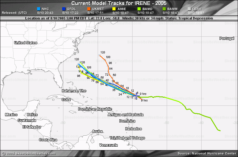
WHILE THE GFDL AND GFDN ARE FARTHER WEST AND BRING IRENE VERY NEAR THE NORTH CAROLINA COAST BY 120 HOURS. THE GFS... HOWEVER... QUICKLY DISSIPATES IRENE AS IT HAS IN THE PAST 48 HOURS OF MODEL RUNS...AND KEEPS THE RIDGE INTACT AND MOVES THE REMNANTS WEST-SOUTHWEST TOWARD FLORIDA AND THE BAHAMAS. THE LATTER SOLUTION WAS DISCOUNTED GIVEN IRENE'S CURRENT WELL ORGANIZED AND IMPROVING CONVECTIVE STRUCTURE.
I think its hard to get a good fix on Irene until it possiibly buildsin strength. But with the dryer air its going to run into is it going to happen?
| Old Sailor |
| (Storm Tracker) |
| Thu Aug 11 2005 03:32 PM |
|
|
|
|
Ed:
If you are in the cone you need to pay attention, Right now that cone covers SC to Mid Jersey.
Dave
| Takingforever |
| (Weather Watcher) |
| Thu Aug 11 2005 03:35 PM |
|
|
Well it's a matter of hours to see if Irene can show how strong she is again. I jsut remember only a week ago Irene was struggling to even be a tropical depression to even get named.
| ftlaudbob |
| (Storm Chaser) |
| Thu Aug 11 2005 03:44 PM |
|
|
|
|
Post deleted. Remaining in thread to preserve continuity.
~danielw
| NewWatcher |
| (Storm Tracker) |
| Thu Aug 11 2005 03:48 PM |
|
|
|
|
we finally have some recon flights scheduled for tomorrow and sat etc.
| Steve H1 |
| (Storm Tracker) |
| Thu Aug 11 2005 04:10 PM |
|
|
And that's what we really need now is a Recon fix. Otherwise we can't say with much confidence where she may go. Even then, its still dicey. Notice the explosion of convection to the SW of the TS in one of its bands. To me it signifies the potential for some significant strengthening as she goes past say 68W. I want to say that the Carolinas are in the path of Irene. However, I want to see some of the 12Z Globals first. The ensembles were still showing strong ridging on the east coast right down to SC. If this is true, ain't no way she's gonna blow through that ridge. If its weaker/more offshore, Hatteras get nailed. But anyone from Florida to the NE coast needs to watch until there is a better handle of the pattern Upstream and here over the Atlantic. Cheers!!
| Lee-Delray |
| (Weather Master) |
| Thu Aug 11 2005 04:16 PM |

|
|
|
Hi-
I was a long time observer, now a first time poster (I read the thread & felt guilty). I know nothing about weather, but have learned a great deal about the science in the last week or so.
For the most part, I find the posts very logical and following methodic patterns.
Though concerned about storms living in S. Fla., I don't get alarmed until they are close. I figure it takes me 5 hours to shutter the house.
I do note however, that tossing "Andrew" around did slightly raise my blood pressure. I do appreciate the comments that suggested it wasn't the same environment.
I have a question; one of the forcaster's at the NHC (Stewart?) was going to retaire and go to Alaska, but decided to stay through the season as he admitted it would be active, but not so for S. FLa. based on the location of the Bermuda high and the correlation to our May rain. Opinions?
Thanks for you patience.
| Ed in Va |
| (Weather Master) |
| Thu Aug 11 2005 04:56 PM |
|
|
I know it's hard to get a fix on Irene's center, but it looks here like the main convection, at least, is going SW:
http://www.ssd.noaa.gov/PS/TROP/DATA/RT/float-ir4-loop.html
| AgentB |
| (Weather Guru) |
| Thu Aug 11 2005 05:10 PM |

|
|
|
Quote:
I know it's hard to get a fix on Irene's center, but it looks here like the main convection, at least, is going SW:
http://www.ssd.noaa.gov/PS/TROP/DATA/RT/float-ir4-loop.html
Ed, that sat is actually of Fernanda in the Pacific. If you click on lat/lon at the top you can see the coordinates. Irene's loop is here.
| stormchazer |
| (Storm Tracker) |
| Thu Aug 11 2005 05:18 PM |

|
|
|
A lot of folks are reading. I myself am not studious enough to comment on the Tropics so I learn and check in on occasions.
My 2 cents on Irene is she appears to still wanna be a fish according to the models. I am holding off judgement until Recon and the NOAA missions do the atmosphere checks. It seems only then, that the modeling takes a firm hold. Of course, Irene might do us all a favor and head North and make those trips unneccessary.
| scottsvb |
| (Weather Master) |
| Thu Aug 11 2005 05:34 PM |
|
|
The system in the E Pac isnt going sw also. Its moving slowly w or wnw but the CDO has shifted to the southside of the storm.
Now with Irene..
I still think there are 2 centers that are elongated to each other. 1 is near 25.5N 64W and the other is elongated to the se of it near 24.5N and 63W. I think the original low slowed down yesterday due to the midlevel low catching up with it. Pulled it in closer and slowed down its movement. Then last night the LLC started N then NW as the midlevel low went by to its N and W. This morning the LLC has been swung around and excellerated to the WNW of the mid level low ( that is trying to be the main center). The NHC mentioned that its hard to pinpoint a exact center with this. Also they said its elongated. You might of rememberd over the last couple days they had a hard time with this and also questioning the speed yesterday. Well I told ya what I feel what happend with the speed, now we have to look at the models.
If this is elongated and we have 2 centers fighting for position...then we will have a hard time getting this above where its at right now. Lets look at what the future might bring on.....
We have the models UKMet and Nogaps taking this to the NW then N to near CapeCod. Meantime we have the Canadian and GFS showing a much weaker system and possilbe open wave heading more w towards Florida or Georgia.
The Nogaps Ive always liked the best and is probably right. But can they both be?
I would come to a compromise and say the 1 center will eventually take over and become the better defined 1. That should be the former mid-level low and it will be the 1 the Nogaps and Ukmet show moving along 70-72N and near CapeCod. The original lowlevel center will be tossed out as a LLvortex and move w or even wsw towards florida and the bahamas. Not sure if it will develop more or not with alot of sinking air with the ridge off of the Carolinas down the Bahamas.
Anyways thats my thoughts of whats been going on and what will happen. They shoulda put recon in there today but they didnt.
| Clark |
| (Meteorologist) |
| Thu Aug 11 2005 05:39 PM |
|
|
Heard some discussion today about Irene potentially being stronger than it is -- if not stronger than Fernanda in the EPac -- as well as to why the recon planes are not out within the storm at this point.
To address the intensity issue, no one can make an entirely accurate assessment on a storm's intensity based off of a mid-level satellite signature, a comparison between two totally different storms, and off of a simple satellite loop. The microwave data help, as do QuikSCAT for winds. A storm displaying an intermittent eye feature with cloud tops 20C colder than Irene over a consistent, condensed CDO feature is much stronger than Irene is, a storm with an excellent mid-level signature and a weak but developing surface signature. We've seen many storms with very good mid-level signatures come back with much weaker recon estimates -- it also work the other way, to be fair -- and Emily this season is a very good example. Earl from not too long ago did the same. That said, the current intensity of the storm is supported by what we do have -- Dvorak estimates and QuikSCAT winds -- and will be augmented by recon starting late tomorrow.
Which brings up the question, "where's recon now?" There have been many, many flights thus far this season. Recon flights are generally only flown into storms for 1) research missions or 2) when they are within 3 days of land. All of those central Atlantic storms get flights because they are some threat to the islands or to interests in the Atlantic. Irene is not threatening any land mass at this point and simply put, there is no need to fly a recon flight into the storm at this time. Would it be nice? Sure. But, alas, we can't always get all of the data we like. And, given that plus the current estimates of the storm, the current intensity of Irene is likely quite accurate.
No large change to the forecast reasoning from last night. A shift northward of the cone might be needed for later, but I would like to see more runs with this storm and the evolving ridge pattern to make any drastic change to the projected track. Needless to say, it's one to watch for people from the FL/GA border northward.
| Ron Basso |
| (Storm Tracker) |
| Thu Aug 11 2005 05:59 PM |

|
|
|
Looking at the VIS SAT I see that Irene is elongating east-west the last several hours. This might be due to her starting to bump into the ridge centered near Bermuda. I think the next 12-24 hours is going to tell us alot about her future movement. The GFS, which doesn't intialize the storm well, shows an ever expanding ridge from now out to 84 hours. Heights increase and the ridge expands westward with the axis from near Bermuda SW to coastal Georgia. If this verifies, it seems like Irene will be bumping into the Great Wall of China. I think from this point forward she will slow down and perhaps change direction to the west or W-NW? Who knows. Or perhaps come to a crawl and meander? I don't see it plowing thru the ridge like UKMET depicts. While the NHC discounts the GFS with Irene's track, I don't discount its building ridge. Makes me wonder where she'll go.
http://www.ssd.noaa.gov/PS/TROP/DATA/RT/watl-vis-loop.html
http://www.rap.ucar.edu/weather/model/displayMod.php?var=gfs_sfc_mslp&loop=1
| emackl |
| (Storm Tracker) |
| Thu Aug 11 2005 06:03 PM |
|
|
Will someone tell me where the goofy center is in this storm? It just looks to me like she's sitting still getting bigger...LOL!
http://www.ssd.noaa.gov/PS/TROP/DATA/RT/float2-ir4-loop.html
| Old Sailor |
| (Storm Tracker) |
| Thu Aug 11 2005 06:21 PM |
|
|
|
|
Scat still 3.0/3.0 so still at 50 mph, looks to be moving at 285 to 290 degrees. 25.4
Dave
| damejune2 |
| (Storm Tracker) |
| Thu Aug 11 2005 06:22 PM |
|
|
|
|
I am wondering if in the near future can anything be done to better predict where these storms will go? Presently they do a pretty darn good job considering not too long ago people had no clue as to where they were going to hit. I was just curious....you know as technology advances, will the predictions get better.
|
danielw
|
| (Moderator) |
| Thu Aug 11 2005 06:33 PM |

|
|
|
Irene looks to be taking some light shear. So there is probably a NE offset between the low level center and the upper center.
Use this enhancement. It's the Dvorak enhancement.
Look for the little tadpole-like tail. It extends off toward the Southwest. Just ahead of that should be the 'center' This is based on CIMSS imagery.
http://www.ssd.noaa.gov/PS/TROP/DATA/RT/FLOAT2/BD/20.jpg
| Random Chaos |
| (Weather Analyst) |
| Thu Aug 11 2005 06:40 PM |
|
|
|
|
I've got no clue where the center is on it, but the banding features are getting more and more pronounced. I'd say it will strengthen rapidly over the next day as the effects of warm water, moist air, low shear, and better storm form (banding) begin push the winds higher.
http://wwwghcc.msfc.nasa.gov/GOES/goeseastnheir.html
| doug |
| (Weather Analyst) |
| Thu Aug 11 2005 06:43 PM |
|
|
Irene looks like it is solidifying a convection core. The center which had been open to the south has now become completley surrounded with convection...still very little going on in the west and south though and it presents with an almost straight line oriented ese-wnw cloud coverage along the southern and western reaches of the overcast area giving an elongated appearance. Outflow exists vigorously only on the north and some less vigorous outflow on the east...nothing in the west northwest or south. Convection does not seem to be building above the mid levels. All of this is why the intensity estimates are probably accurate for now.
If the development around the center can maintain and it may as it proceeds toward warm water it can still pull itself together into a hurricane. I don't see the dissapation the GFS called for, bur it is still pretty fragile. I see nothing to suggest it is a hurricane now.
No reason to think it will not continue wnw especially if strengthening continues, as I cannot evaluate the relative strength of the ridge or the timing of the trough. Florida should be safe though.
| Hurricane Fredrick 1979 |
| (Weather Guru) |
| Thu Aug 11 2005 06:52 PM |

|
|
|
Quote:
I am wondering if in the near future can anything be done to better predict where these storms will go? Presently they do a pretty darn good job considering not too long ago people had no clue as to where they were going to hit. I was just curious....you know as technology advances, will the predictions get better.
I saw on NASA Tv yesterday where they have got another sat called GIFTS that is suppose to get the info back in min instead of hours and that it will show 3D images and its suppose to be quiet better than the GOES sats. But they didn't say when it will be launched.
| doug |
| (Weather Analyst) |
| Thu Aug 11 2005 06:55 PM |
|
|
This year the models seem to have been much more reliable especially out to 72 hours...last year they were awful... didnot have any clue on the ridge....see if the end game in this one is not within the cone at the 5 day mark I think it will be. When you consider that the cone may cover 500-600 miles of coast line at 5 days that may seem like a huge absolute difference for the coast line involved, but when considered against the entire potential surface thatcould be effected that is the equivilant of a pin hole. So on a relative scale I think it is pretty good accuracy.
Remember the weather is a dynamic interaction of unstable gases and other forces which can change in an instant.
I did not follow up on becoming a met because I could not handle the physics!
| Takingforever |
| (Weather Watcher) |
| Thu Aug 11 2005 07:00 PM |
|
|
Yeah unless this thig starts to go just west, Floridans can say they are safe.
But I think this was a safe bet for alot of you, I mean compared to Floyd's track in 1999, this is a piece of cake
| Unregistered User |
| (Unregistered) |
| Thu Aug 11 2005 07:09 PM |
|
|
Quote:
they have got another sat called GIFTS that is suppose to get the info back in min instead of hours and that it will show 3D images and its suppose to be quiet better than the GOES sats. But they didn't say when it will be launched.
GIFTS will not launch until 2012.
| Storm Hunter |
| (Veteran Storm Chaser) |
| Thu Aug 11 2005 07:20 PM |

|
|
|
i think irene is going to pass close to ilm and mhx. Got family in ilm, says local media is jumping on it like most media in FL has done in this year....the basic, get your supplies, etc.
side not, the wave at 22w 11n is the most impressive i've seen this year to look this good, just after the exit from africa...it's large and if holds together...could be an invest within 24-48hrs..... take a look..... as clark said, things are about to get very active!!!!
| Ryan |
| (Storm Tracker) |
| Thu Aug 11 2005 07:25 PM |
|
|
|
|
Quote:
i think irene is going to pass close to ilm and mhx. Got family in ilm, says local media is jumping on it like most media in FL has done in this year....the basic, get your supplies, etc.
side not, the wave at 22w 11n is the most impressive i've seen this year to look this good, just after the exit from africa...it's large and if holds together...could be an ivest within 24-48hrs..... take a look as clark said, things are about to get very active!!!!
whats ilm and mhx?...and yes that wave does look liek it has itself together prety well.
| hurricane_run |
| (Storm Tracker) |
| Thu Aug 11 2005 07:26 PM |

|
|
|
that wave does look pretty good. here's another look at it ir sat pic
| Unregistered User |
| (Unregistered) |
| Thu Aug 11 2005 07:28 PM |
|
|
I know people especially in Florida don't want to hear this, but i have noticed Irene is starting to turn more toward the West. This could be a slight abbaration, or something suggesting a larger course change.

In the future, please provide some sort of background for what you see in the satellite imagery, models, forecasts, etc. that backs up why you believe this is occurring. Such comments aren't necessarily bad or out of line, but some sort of justification is required. Thanks... --Clark
| LI Phil |
| (User) |
| Thu Aug 11 2005 07:30 PM |
|
|
|
|
Quote:
whats ilm and mhx?...and yes that wave does look liek it has itself together prety well.
i believe they are the airports or call letters for Wilimington & Morehead City respectively, cities in NC
| Takingforever |
| (Weather Watcher) |
| Thu Aug 11 2005 07:30 PM |
|
|
Quote:
take a look as clark said, things are about to get very active!!!!
And the only thing that would be stopping all these storms from hitting the East coast right now is the ridge that's causing the heat wave and thunder boomers up and down the coast. Once that's gone, it's less out to sea
| Storm Hunter |
| (Veteran Storm Chaser) |
| Thu Aug 11 2005 07:39 PM |
|
|
|
|
opps! they are
(ilm)
Wilmington, nc
(mhx)
morehead city, nc
two biggest cities on east coast of nc....
| LoisCane |
| (Veteran Storm Chaser) |
| Thu Aug 11 2005 07:42 PM |

|
|
|
pretty wound up
http://www.ssd.noaa.gov/PS/TROP/DATA/RT/rgb-loop.html
| amonty |
| (Weather Hobbyist) |
| Thu Aug 11 2005 07:43 PM |
|
|
|
|
Wow check out the explosion of water vapor(purple) in the last few frames its pretty impressive
link
| Ryan |
| (Storm Tracker) |
| Thu Aug 11 2005 07:46 PM |
|
|
|
|
ohh ok well that would explain a lot, yea if Irene takes the patht that the NHC is predicting, she will be a little to close for comfort in NC, and then she looks to be heading north and a little to the west so maybe she'll make more than one landfall, hopefully not but we can only wait and see, a lot of the models show Irene's eye brushing the NC coast and then not surprisingly, NOGAPS the entire grid annot be shown because there is so much uncertainty about Irene, this are just my opinions what do other people think?
Ryan
| rmbjoe1954 |
| (Weather Master) |
| Thu Aug 11 2005 07:50 PM |
|
|
|
|
I still see- WNW track. What is your source?
| Old Sailor |
| (Storm Tracker) |
| Thu Aug 11 2005 07:55 PM |
|
|
|
|
Joe:
School out for the day no facts just he likes to get to people, looks to me she headed 290 to 295 W-NW
Dave
| nl |
| (Storm Tracker) |
| Thu Aug 11 2005 08:04 PM |
|
|
|
|
as long as any hurricane doesnt hit on the fsu vs miami game ill be fine i guess. go noles!

| MoparMitch |
| (Weather Watcher) |
| Thu Aug 11 2005 08:09 PM |
|
|
Clark,
I am sure flying recon is not cheap, but do have some sort of idea how much money it costs to fly a mission? I also understand that a "single" mission is not just a fly-by rather a 12+ hour ordeal.
No specific numbers on the recon flights, but it can be a multiple day ordeal -- particularly for storms out beyond 70W, as they often base those flights (either going out there or coming back) in the Virgin Islands. There is a finite budget for the flights each season, and there are many other uses of the planes than for tropical activity -- research projects, field programs, the whole shebang. --Clark
Your thoughts...
| Clark |
| (Meteorologist) |
| Thu Aug 11 2005 08:16 PM |
|
|
Irene is more or less holding her own this afternoon. The colder cloud tops are really obscuring things in trying to find where the low-level center is located. Add in that the circulation is not very large at all and it becomes even more difficult. Here's my best guess as to the structure and setup of the storm right now...
On visible imagery, cloud motions north of the main cloud pass are rapidly going from east-southeast to west-northwest, but not curving around into the storm's center. This gives further credence to the idea of a small circulation and is also likely one of the two regions where the strongest winds are associated with the storm. Cloud motions to the south of the storm at low levels are sprialing inwards, but not at a strong clip. With low clouds curving around to a N-S orientation near the current convective blowup at about 25.5N/62.5W, this suggests the center is further west of that mass. The speed of these low clouds, particularly further to the west, suggests that the circulation is not well define on the south side...but it is and has been closed per visible satellite imagery over the past week, just too small to accurately be captured as a closed low by the QuikSCAT passes at times.
The colder cloud tops on the western edge of the storm (looking at about 25.5-28N, 63.5-65W) are largely cirrus clouds; there is little convection associated with them at this point. An outflow boundary is racing to the NW out of this region, clearly evident on visible satellite imagery and an indicator of the collapse of the convection in this area several hours ago. I would expect cloud tops in this area to warm over the coming hours before convection redevelops there later tonight. In the meantime, some colder cloud tops are building to the east and southeast of the center of circulation; these will likely persist for some time as well.
Given the satellite appearance, the mid-level center would appear to be in the middle or on the eastern edge of the "colder" cloud tops to the NW of the deep convection, somewhere near 26-26.5N/63.5W. The actual low-level center is likely displaced from there, albeit not to a huge degree, and is located near 26N/64W, give or take. It is possible that there are multiple swirls rotating around the larger center, but we don't have accurate enough data to make that call at this time.
Given the current structure of the storm, winds are likely still around 50mph, given no improvement in the satellite signature of the storm and nothing else to suggest that winds are any higher at this point, cloud track and QuikSCAT winds included in that. Slow strengthening is still possible, but I don't see any rapid deepening likely in the near term. Think Emily, before it got to the islands, and that's probably a good marker for how this storm may try to get organized.
| Unregistered User |
| (Unregistered) |
| Thu Aug 11 2005 08:27 PM |
|
|
I've been tracking Irene's movements for the last few days and in the last 12 hrs I've noticed a settle change in direction it's stil WNW but it's slowly angling towards the West. At least this is what my observations have been recording.
| ralphfl |
| (Weather Master) |
| Thu Aug 11 2005 08:42 PM |
|
|
Ok the 5pm is out now and its still going wnw and looks more to be turning out to sea then to the US mainland.
Still have to watch it but the models keep trending east.
Also contary to the above post it seems more nw now then before.
also winds still 50 and the pressure is the same so no stronger then last time around.
in the future, if you have another immediate thought to add, just tack it onto the post. like so. -HF
| ralphfl |
| (Weather Master) |
| Thu Aug 11 2005 08:45 PM |
|
|
This post was sent to the Hurricane Graveyard
| doug |
| (Weather Analyst) |
| Thu Aug 11 2005 08:45 PM |
|
|
IR 2 suggests that a pretty strong W-E shear was still effecting the system which could account for the fact that the circulation remains in the NW quardrant of the envelope, although recent photos show some new convection east and north of where the center seems to be per Clark.
| Ed in Va |
| (Weather Master) |
| Thu Aug 11 2005 08:46 PM |
|
|
Not really much change in the track. Seems to be slowing quite a bit, though.
http://www.wunderground.com/tropical/tracking/at200509_5day.html
| NONAME |
| (Weather Guru) |
| Thu Aug 11 2005 08:46 PM |

|
|
|
http://www.nhc.noaa.gov/text/MIAREPRPD.shtml?
noname wants everybody to see the recon plan for tomorrow (which has been discussed several times earlier today. try posting links rather than huge text sections.. unless you have a few thoughts to go with your excerpt. -HF
| Storm Hunter |
| (Veteran Storm Chaser) |
| Thu Aug 11 2005 08:54 PM |
|
|
|
|
http://www.ssd.noaa.gov/PS/TROP/DATA/RT/float2-rgb-loop.html
irene rgb shot
| rmbjoe1954 |
| (Weather Master) |
| Thu Aug 11 2005 08:59 PM |
|
|
|
|
That sat pic shows Irene dancing here way 'North' north-west.
| Unregistered User |
| (Unregistered) |
| Thu Aug 11 2005 09:49 PM |
|
|
my earlier post #47471 .......well nice to know i was in the ball park....
from the TCDAT4
5m dics.
AN UPPER-LOW TO THE SOUTH OF IRENE HAS BEEN ADVECTING DRY MID-LEVEL
INTO THE SOUTHERN PORTION OF THE CYCLONE TODAY ...WHICH HAS CAUSED
THE CONVECTION TO ERODE AND WEAKEN AT TIMES. HOWEVER...WATER VAPOR
IMAGERY INDICATES THE LOW HAS BEEN WEAKENING AND THAT THE MID- TO
UPPER-LEVEL FLOW IS GRADUALLY BECOMING SOUTHEASTERLY.
the west side of irene is now looking better....great outflow...(stronger storm later on)
take a look at wv
| meto |
| (Weather Guru) |
| Thu Aug 11 2005 09:51 PM |
|
|
strong wave just off africa, some monster ones will be coming off in the next week. hang on. ............................
| firestar_1 |
| (Weather Hobbyist) |
| Thu Aug 11 2005 10:01 PM |
|
|
|
|
After looking at the steering currents today, I am thinking there is a very good chance over the next 18 hours to see her head more nnw between the two highs...is this possible?
http://cimss.ssec.wisc.edu/tropic/real-time/atlantic/winds/winds-dlm.html
:?:
| MapMaster |
| (Weather Guru) |
| Thu Aug 11 2005 10:05 PM |

|
|
|
OK, no one get excited...I have noticed the since last night it actually looks quite a bit like Andrew at about the same stage/location when it developed. This is NOT Andrew, and the set up isn't the same, but, just interesting to note.
Of greater interest is the sudden appearance of probabilities all over the east coast of Florida...and that we are a little deeper in the TS force wind cone.
The probabilities north to south, including Bermuda, show very little spread...jury is still out....
MM
| MapMaster |
| (Weather Guru) |
| Thu Aug 11 2005 10:07 PM |
|
|
|
|
Deleted by author...already answered!
| Lee-Delray |
| (Weather Master) |
| Thu Aug 11 2005 10:09 PM |
|
|
|
|
I don't see the Florida probabilities; where do I find them.
| Ron Basso |
| (Storm Tracker) |
| Thu Aug 11 2005 10:10 PM |
|
|
|
|
Sorry for the long copy but I need it to make a point here.
Per NHC's 5 PM Discussion:
THERE HAS NOT BEEN MUCH CHANGE IN THE MODEL FORECAST
TRACKS OR THE MODELS' HANDLING OF THE SUBTROPICAL RIDGE TO THE
NORTH OF IRENE AND THE ALLEGED WEAKENING OF THE WESTERN PORTION OF
THE RIDGE AFTER 72 HOURS. HOWEVER...IT SHOULD BE NOTED THAT NONE OF
THE MODELS CREATE A WEAKNESS IN THE RIDGE DUE TO A SHORTWAVE TROUGH MOVING INTO THE MEAN RIDGE POSITION. THE NOGAPS AND UKMET MODELS ERODE THE RIDGE AS A RESULT OF AMPLIFYING IRENE TO A SIZE NEARLY THE SAME AS THAT OF THE SYNOPTIC SCALE HIGH PRESSURE CENTER NEAR BERMUDA...WHICH RESULTS IN IRENE TURNING SHARPLY NORTHWARD ALONG 70W LONGITUDE BY 72 HOURS. THAT SCENARIO SEEMS LESS LIKELY...GIVEN THE CURRENT SIZE AND STRENGTH OF THE BERMUDA RIDGE AS NOTED IN WATER VAPOR IMAGERY AND UPPER-AIR DATA. THE GFS HAS CONTINUED ITS TREND OF DISSIPATING IRENE WITHIN 48 HOURS AND MAINTAINING AN EAST- WEST ORIENTED MID-LEVEL RIDGE FROM BERMUDA WESTWARD TO THE CAROLINAS.
I dunno about most of you, but I read alot of doubt into the 5 PM discussion. When the MET says "Alleged" weakness in the ridge after 72 hrs this doesn't sound confident. In addition, what's bothering me about this storm is that the GFS and CMC have consistently dissipated this storm over the last 2-3 days of model runs along with the GFDL which one run its a tropical storm and then the next run is an open wave. Like the NHC states, the NOGAPs and UKMET create a huge storm that dwarfs the ridge, thereby allowing it to slice thru it. So, overall, we don't have any model consensus. Usually with a stronger storm, we may have differing tracks but we don't have 2 models evaporating the storm and 2 models creating a mega-storm. I think the NHC is scratching their heads, too, over its path in the long range (3-5 days) by really slowing the storm to a crawl. Right now, the storm can either dissipate in 48 hours, turn west or W-SW in the next 24-48 hours, get trapped within the ridge and meander at less than 5 kts, or rapidly develop into a strong hurricane and head north out to sea. Anyone got a wegee board?
good insight ron. it's ouija board.. but this isn't a spelling bee. -HF
| NewWatcher |
| (Storm Tracker) |
| Thu Aug 11 2005 10:17 PM |
|
|
|
|
Very good points Ron, I was thinking the same thing about the models not being in agreement. Scratching my head also
| Rob1966 |
| (Registered User) |
| Thu Aug 11 2005 10:30 PM |
|
|
As always, is a wait and see. Next 24 hours "should be" a bit more enlighting. With so much uncertainy how will Jim Cantori know where to go?
| nl |
| (Storm Tracker) |
| Thu Aug 11 2005 10:47 PM |
|
|
|
|
what is that behind irene?
| Ron Basso |
| (Storm Tracker) |
| Thu Aug 11 2005 10:58 PM |
|
|
|
|
When is the recon scheduled for Irene? Given the existing model uncertainty, I wouldn't be surprised to see a major track change after the recon locates the LLC and we get some sampling of the upper air environment surrounding the storm.
| Old Sailor |
| (Storm Tracker) |
| Thu Aug 11 2005 11:51 PM |
|
|
|
|
I allways go with the model groupings and NHC has the best record for past history of Hurricanes then anybody else.
That being said I feel the models will back off some and looks more like a SC land fall, Watching Irene the last few hours she going allmost NW looks to be 310 to 315 degrees.
Dave
| Hootowl |
| (Weather Hobbyist) |
| Thu Aug 11 2005 11:55 PM |
|
|
The last I saw the recons we scheduled for late tomorrow afternoon. Don't know if that has changed. I did notice the following when I checked on our point forcast from NOAA this afternoon......
LONG TERM (SAT NIGHT-THU)...EXTENDED MODELS HAVE COME MORE IN LINE
WITH A MORE TYPICAL LATE SUMMER PATTERN. WEAK UPPER RIDGING TO HOLD
OVER THE REGION THRU THE PERIOD WHILE SERIES OF SOMEWHAT WEAK VORT
MAXES ROTATE IN THE OVERALL FLOW. SURFACE HIGH PRESSURE FROM THE
WESTERN ATLANTIC...BERMUDA HIGH...TO RIDGE ACROSS NORTH FLORIDA AS
WELL. THESE FEATURES TO CREATE MAINLY EASTERLY FLOW AND GENERATE
MAINLY AFTERNOON AND EVENING CONVECTION ALONG SEA BREEZES AND OUTFLOW
BOUNDARIES.
These guys (our point forecast) are pretty much on the money. (I know they were last year - I depended on them a lot - didn't know about this forum then) I don't know exactly when or how strong they are depending on the ridge (Bermuda High) to be across Florida - but it could make a big difference.
Sorry for the long post.

Dotty
| ROB IN PA |
| (Registered User) |
| Fri Aug 12 2005 12:08 AM |
|
|
A quick question on the track. The NHC has Irene of NC coast by Tuesday. If she is tracking NW and stays the course she would go right up the Cheasepeke bay to Baltimore. My question is how feasable would that be and has it happened before. Also let say she is cat 2 what kind of damage would that area get. Again thanks to all for your info.
| HanKFranK |
| (User) |
| Fri Aug 12 2005 12:10 AM |
|
|
|
|
sailor... as per your movement take.. you may be right, but i'm reckoning that the center is still on the western side of the convective shield... the 300-ish track is probably good. as far as you calling it here to sc... well, don't think it'll make it that far west. the globals have been consistently taking irene too far to the north.. except for the euro. late in the forecast period they tend to show erratic movement.. probably because the ridge is building and they're responding too slow/jamming it into the ridge. if you look at what the ensembles show compared to what the globals are progging.. they're probably underdoing the strength and resilience of the ridging near the mid atlantic. if i was a bettin' man, i'd go with north carolina. the offshore option is probably #2... sc is #3.
other stuff... noticed that the increase in convection/lower shear values that have been overspreading the basin... an mjo effect.. are now getting into the eastern atlantic. that itcz wave near 40-45w has good convergence.. in spite of low amplitude.. based on the evolving pattern that thing needs to be watched. the high amplitude wave coming off africa will be a candidate in a few days as well.
noticed pressure falls in the gulf on the euro run joe b showed this morning. not sure which feature that's related to. maybe a weak wave responding to pattern forcing. have to see if that persists from run to run.
HF 0010z12august
| nl |
| (Storm Tracker) |
| Fri Aug 12 2005 12:19 AM |
|
|
|
|
what is that behind irene?
| Kevin |
| (Weather Master) |
| Fri Aug 12 2005 12:20 AM |
|
|
|
|
On the topic of the new Atlantic wave...here is the 8:05 PM TWD take...
TROPICAL WAVE LOCATED ABOUT 100 NM W OF THE AFRICAN COAST ALONG
18W/19W S OF 19N MOVING W 5-10 KT. A 1008 MB LOW IS LOCATED
ALONG THE WAVE ABOUT 70 NM NW OF DAKAR NEAR 15N18.5W BASED ON
WIND AND PRES OBSERVATIONS FROM NEARBY SHIPS AND LAND STATIONS.
THE WAVE IS DEVELOPING A WELL-DEFINED SIGNATURE WITH MID-LEVEL
CLOUDINESS BEGINNING TO "SPILL OVER" THE WAVE AXIS FROM THE
E...AND CONVECTION BEING ORIENTED ALONG A LINE FROM S OF THE
CAPE VERDES NEWD INTO W/CNTRL MAURITANIA. SCATTERED
MODERATE/STRONG INLAND OVER WRN MAURITANIA AND SENEGAL FROM
13N-22N BETWEEN 11W-17W. OTHER DEEP CONVECTION IS FARTHER W
ALONG THE ITCZ. SHOWERS/TSTMS ARE EXPECTED TO MOVE OVER THE CAPE
VERDE ISLANDS ON FRI AND SAT AS THE WAVE PASSES BY.
Already shows an area of developing low pressure. I'd expect an invest on this wave, provided that it holds together well enough.
| Spoken |
| (Weather Hobbyist) |
| Fri Aug 12 2005 12:33 AM |
|
|
I've found an answer to a remarkably ignorant question I'd submitted yesterday (here at this forum) concerning a ridge shielding the southeastern U.S. from Irene. Please note that I've taken it upon myself to delete the question.
However, as long as I've surely taken up other people's time even if merely to read the silly thing, I've found what appears to be a rather comprehensive glossary at WeatherQuests. Their glossary is currently located at http://www.weatherquests.com/services/knowledge/glossary/
Granted, their glossary appears to be missing such terms as Prepapathy, Wave Monger and Wishcasting – and several others – which are explained under "TERMS TO KNOW" at http://flhurricane.com/general.php
Also, please let me know if WeatherQuests is a competitor to one of this site's supporters (and I'll gladly delete this submission too). And thanks again!!
| Old Sailor |
| (Storm Tracker) |
| Fri Aug 12 2005 12:39 AM |
|
|
|
|
Hank:
I'm not trying to or wish Irene on SC, guess we all see things in the models and ridge building, I was just lookiing at the big picture standing back, granted Eastern NC sticks out like catch basin and history has proven NC bound to get hit few times.
Without knowing the true center of Irene it is hard to say if 300 or 310.
Dave
wish it here? no, i know you're not. i'm not certain, but got a hunch it doesn't get over here. of course, the latest gfdl is sending it this way. that'd better not keep up. -HF
| Old Sailor |
| (Storm Tracker) |
| Fri Aug 12 2005 12:49 AM |
|
|
|
|
Latest scat out 3.0/3.0 still at 50mph, did the math on Lon/Lat track is about 300 degrees.
PS looking back a 11:00AM track Irene a little north .2 degrees of that track.
Dave
that's if you believe the scatt/dvorak position. the last light visibles do suggest the center is on the west side. -HF
I was going from the last scatt positon to now, only way of judging till Recon get there finds the true center.
Dave
| LI Phil |
| (User) |
| Fri Aug 12 2005 12:50 AM |
|
|
|
|
>>> Granted, their glossary appears to be missing such terms as Prepapathy, Wave Monger and Wishcasting – and several others – which are explained under "TERMS TO KNOW" at http://flhurricane.com/general.php
it's also missing "banned" and "on probation"...terms you don't want to learn...
| nl |
| (Storm Tracker) |
| Fri Aug 12 2005 12:52 AM |
|
|
|
|
i was asking what is that behind irene? cause i know im not just seeing things on this floater. it looks like something is trying too catch her. http://www.ssd.noaa.gov/PS/TROP/DATA/RT/float-ir4-loop.html
check that out i know im not seeing things and tell me what that is.
that's fernanda and greg. wrong ocean, man. -HF
| NewWatcher |
| (Storm Tracker) |
| Fri Aug 12 2005 12:55 AM |
|
|
|
|
NL try putting on the lat/lon button and you will see that you are not watching
Irene......
| Unregistered User |
| (Unregistered) |
| Fri Aug 12 2005 12:56 AM |
|
|
That is not irene you are looking at
you should register, man. your sig could be VOTE FOR PEDRO. -HF
| Unregistered User |
| (Unregistered) |
| Fri Aug 12 2005 12:59 AM |
|
|
The models have made a big shift to the west the last past hours go check were the gfdl model is know very close to south carolina we will have to wait and see what happends dont think florida is still out of the woods yet
| damejune2 |
| (Storm Tracker) |
| Fri Aug 12 2005 01:09 AM |
|
|
|
|
She'd better hurry up then and get going!!! She is almost due west of Miami now, maybe even a little north of that lat/lon......if florida takes a hit from her i'd have to say further up the coast, like maybe the Cape or Jax.
| damejune2 |
| (Storm Tracker) |
| Fri Aug 12 2005 01:23 AM |
|
|
|
|
How reliable is this Navy site concerning the future path of the storm and or any storm??
http://www.nrlmry.navy.mil/tc_pages/ATL/09L.IRENE/ssmi/gif/full/Latest.html
| L.I. |
| (Registered User) |
| Fri Aug 12 2005 01:23 AM |
|
|
Nobody is talking about the possibility of Irene making it to Long Island. She seems to be following the same path as Gloria. Is there a chance Irene will make it as far north as Long Island and then recurve out.
| damejune2 |
| (Storm Tracker) |
| Fri Aug 12 2005 01:24 AM |
|
|
|
|
LilPhil - I clicked on the link that was in the quote section of your post and nothing happens - i get an error page. I was going to read the terms but cant find them. Am i not looking good enough?
| BillD |
| (User) |
| Fri Aug 12 2005 01:29 AM |
|
|
The forecast map on the NRL site uses the NHC forecast track. I don't know that there is any data on the NRL site that is not available elsewhere, but they do a good job of putting everything you'd ever need to look at all on one page (if you can figure out all the acronyms on the links...)
Bill
| LI Phil |
| (User) |
| Fri Aug 12 2005 01:29 AM |
|
|
|
|
OK...it's NOT Lil Phil...it's
LI as in LONG ISLAND Phil...
don't worry...you're only about the 20th person to make that mistake
try this link
| richisurfs |
| (Weather Guru) |
| Fri Aug 12 2005 01:29 AM |

|
|
|
Is a storm located at 25.7N and moving WNW "near 15 MPH" at the last advisory going to take an abrupt turn to the west all of a sudden and head towards Florida? That is basically what would have to happen and none of the models are showing that.
| damejune2 |
| (Storm Tracker) |
| Fri Aug 12 2005 01:33 AM |
|
|
|
|
Sorry Phil.....

| Ron Basso |
| (Storm Tracker) |
| Fri Aug 12 2005 01:39 AM |
|
|
|
|
Looking at IR SAT, it looks like the LLC of Irene is displaced from the mid level center. It appears the LLC is on the west side of the cloud mass and the MLC is displaced to the NE. If this the case, I don't see any rapid strengthening. It also looks like the LLC is moving W-NW, somewhere between 280-300 deg. I'm wondering if its possible that the MLC separates from the LLC, with the LLC moving W-SW and the MLC moving off to the N-NW. Maybe this is what GFS model is picking up.
http://www.ssd.noaa.gov/PS/TROP/DATA/RT/watl-ir4-loop.html
| Clark |
| (Meteorologist) |
| Fri Aug 12 2005 02:10 AM |
|
|
What has changed since last night, overall? Not a whole lot, really, but enough to make mention.
The upper-low noted east of the Bahamas yesterday is still there, though it is slowly moving west and showing signs of narrowing. However, this is where the weakness is right now and what is likely sending Irene on a 300deg path. If Irene keeps going at this path, it may well round through the weakness in the ridge pretty slowly and ultimately head out to sea. Not a strong possibility, but there nonetheless. The satellite data suggest this is possible moreso than the actual height data -- the ridge north of Irene is narrow and, per the steering flow data available at the UWisconsin site, is weak enough to allow for something to slide through. As a result, I wouldn't be so quick to discount the NOGAPS/UKMET solutions just yet.
However, as this feature moves west, the storm should start to veer back to the west-northwest. Other than this feature, the tendency would be for Irene to move closer to 285deg. I expect a general 290deg motion to resume tomorrow, assuming the upper low continues to move away/fill. The next weakness lies directly along the coast, stretching from the Outer Banks across the northern parts of Ga/Al/Ms, but does not appear to be moving any further southward. A number of weak upper-level lows have formed along this boundary back to the west, with a persistent TUTT cell in the northern Gulf of Mexico. I don't expect a lot of motion from these features, but their building will help to amplify the pattern just slightly. Whether this means a tendency to send the storm more towards the west or more towards the north remains to be seen...right now, either possibility is about equally likely. The flow remains zonal across the eastern 2/3 of the US -- a shortwave trough is passing just to the north of Irene right now and may have also played a role in the jog northward today -- and with nothing down the line to suggest this will change, it is going to be fluctuations in the intensity and position of the subtropical ridge and boundary draped across the SE US that determine where this storm ultimately goes. Georgia is looking less likely with time as well, and the all-clear can about be sounded for a direct impact to Florida, but folks from Savannah northward really need to keep an eye on this one.
The low-level center and mid-level center are not aligned very well this evening -- another reason why you don't use infrared satellite imagery as the sole marker of a storm's intensity -- with the former moving ~300deg and the other building closer to ~315deg with the morphing of the convective pattern. As a result, I don't expect any change in intensity once again at 11pm. Once -- if -- the two become better aligned, some modest intensification is possible and likely. It is relatively dry in the vicinity of the storm, but not as much as before. Shear is still present, but the transverse banding features (e.g. outflow pattern) are getting better defined, especially to the north and east, with time. The GFS solution is possible, given the current state of organization, but not likely at this point.
More tomorrow, if needed...we'll get the first recon fixes in time for the 5p advisory package tomorrow afternoon.
|
MikeC
|
| (Admin) |
| Fri Aug 12 2005 02:54 AM |
|
|
Well the 11PM is out, not too much change other than a potential for it to slow up. They mention a few points about not going into specifics yet about any east coast affect from the storm, which is pretty good advice concerning the situation with it.
Nothing has changed for me on thinking yet. Hoping/looking for ways for the storm not to hit land, and watching it otherwise.
| Joe |
| (Storm Tracker) |
| Fri Aug 12 2005 03:06 AM |
|
|
Heres a look at the current model output on Irene along with model performance numbers for just about every hurricane model.
http://hurricane.methaz.org/hurapak/AAL092005_perf.html
My overall thinking hasn't changed much and agree with the NHC forecast for now, even though there has been some swing in guidance to the west in the 72-120 hour timeframe, rather wait and see what future trends hold considering each day they have gone back and forth.
| zacros |
| (Weather Hobbyist) |
| Fri Aug 12 2005 03:13 AM |

|
|
|
Given this storms ability to organize and strengthen during the early morning hours while it was traversing across the Atlantic, it will be interesting to see what the morning holds. I believe shear is still lessening and the effects of the ULL are decreasing as well. It seems to me that the storm should strenghten some tomorrow. Hopefully, this will increase the chance of finding a weakness in the ridge and turn north before it hits land.
| Unregistered User |
| (Unregistered) |
| Fri Aug 12 2005 03:16 AM |
|
|
This post was sent to the Hurricane Graveyard
read the forum rules about posting. short 'chat room' type comments are not permitted on this forum. your topic was fine, though. -HF
| Unregistered User |
| (Unregistered) |
| Fri Aug 12 2005 03:18 AM |
|
|
This post was sent to the Hurricane Graveyard
|
SkeetoBite
|
| (Master of Maps) |
| Fri Aug 12 2005 03:34 AM |
|
|
|
|
Hey everyone, sorry I've been absent lately. Working around the clock to finish the new site... Anyhow, here's a quick update:
Although the site isn't quite finished, Irene is a bit too close for comfort. Given the lack of confidence in the forecast path, we are releasing the new track maps early to accommodate the folks who rely on them.
Please do not pull full size images from SkeetobiteWeather.com into the forums. This creates a serious load on the server and is unfair to those using dial up. Each full size image that is available for use in the forums will include the necessary forum code to generate a thumbnail that links directly back to the map you are interested in.
Example(Live data)

Image courtesy of SkeetobiteWeather.com
Currenty, the forum code will be included under each image you can use. Once we launch the new site, look for this image:

Clicking this link will automatically generate the forum code for you. Just copy and paste it into your post!
| tpratch |
| (Moderator) |
| Fri Aug 12 2005 03:36 AM |

|
|
|
The models are typically not run until an invest is given for any given storm.
Sometimes, model runs on other storms will pick up formations, sometimes not - at any rate, that close to the coast of Africa, there's nothing to mention - other than the fact that we're a scant few days away from the traditional start of the CV season...
Nice looking image, Skeet. Let me know if I can give you a hand getting anything wrapped up.
| Ryan |
| (Storm Tracker) |
| Fri Aug 12 2005 03:38 AM |
|
|
|
|
lets say Irene follows the NHC 5 day projected path, from 8PM Monday-8 PM Tuesday she looks to be taking a straight dash for land, and we could see another invest whats this 99L?...but i mean hopefuly with the EPAC being really active maybe the atlantic won't be, then again this season has already provn to be an unpredictable one, i think it was clark that said anywhere from savannah northward should watch Irene, most of the models arent showing a possible Georgia landfall, and i think she will take a path relitavely similar to the NHC becuase of the trough over the central atlantic, i think she may ride the edge of the trough rather than breakign through it and turning out to sea, what do othe rpople think, a second and third opinion neevr hurts right. Also, one more thing-if you are in "the cone": should we be on alert?
Thanks, Ryan
| Spoken |
| (Weather Hobbyist) |
| Fri Aug 12 2005 04:40 AM |
|
|
The 11PM didn't seem to report on it but the subtropical ridge now appears to extend further east of North Carolina than it had earlier in the evening.
http://www.ssd.noaa.gov/PS/TROP/DATA/RT/nwatl-wv-loop.html
My understanding is that the "subtropical" ridge is between 35N and 40N.
| HanKFranK |
| (User) |
| Fri Aug 12 2005 04:56 AM |
|
|
|
|
wow, clark touched all the bases on irene. i don't suppose i could describe irene's current state so well. will just rubber stamp it and say 'what he said', 'cause it adds up.
i'll try to do the math elsewhere. there has been some commentary on the itcz feature near 40w. there is strong convergence and a monsoon-trough type gyre there along 10N, with the curvature becoming more apparent with time. the convection there is modest, but over to the west near the caribbean the general extent and appearance of convection is already improved... perhaps due to mjo's arrival. the 40w itcz feature is getting mention in the nhc TWO as of 1030pm... right now it needs to start dislodging from the itcz if it is to develop. i'd expect this to happen as it moves west over the next couple of days... it will likely be an invest tomorrow or saturday.
there's a large amplitude wave just off of africa with an associated low. since it doesn't have the slam-dunk development sort of organization, it will probably not do anything for a couple of days either. it should also move west, perhaps also becoming an invest late in the weekend or early next week.
worthy of mention is the general lowering of pressures some of the globals have shown in the gulf in a few days. whether they're on to a pattern that favors development remains to be seen.
i'm gonna go look at the 00z runs and see if anything new stands out.
HF 0455z12august
| ShanaTX |
| (Storm Tracker) |
| Fri Aug 12 2005 09:10 AM |
|
|
5 am advisory etc out. Recon flights today should be very interesting. With Irene getting stronger and expected to slow down... more chance for recurve?
Looks like NHC thinks Irene will get to Hurricane tomorrow...
'shana
| WXMAN RICHIE |
| (Weather Master) |
| Fri Aug 12 2005 09:15 AM |

|
|
|
A local weather forecaster has this to say about Irene. Does anyone think something like this is possible considering the storm is moving NW and intensifying currently?
One thing I see is the building mid level high which will extend itself across the Carolina coast. If Irene becomes imbeded in this building 500mb high this would indeed weaken it. In fact what I see here in the next 3 to 5 days it weakens to a wave and moves westward toward NW Bahamas. The mid level high actually builds so much over it too that it pushes it soutward too. This could raise the rain chances for our area for early next week. We will have to keep an eye on this situation considering that I have forecasted at least 9 inches of rain for our area for August and this may be one situation we could get a significant rain event. This is evident as an inverted trough at 500mb for Monday heading toward NW Bahamas. In fact High pressure builds from mid levels to the surface also in the area over and north of Irene. So this does raise some questions as to whether even Irene gets to be a Cat 1 storm. As of now it looks like whatever is left from Irene the dynamics and effects of it may effect our area at least what will be left of it...it looks to me like it will be squeezed out of all its moisture especially being imbedded into a dry mid level high pressure area. The low level entity maybe all what is left when it gets here if it ever does or what is left of it. The scenario is a confusing one when one tries to see this on the GFS Model.
| craigm |
| (Storm Tracker) |
| Fri Aug 12 2005 10:24 AM |
|
|
|
|
Here is the link to the steering flows Clark referred to last night( I think) and their changes in the last 24 hours and 5 day movies.
http://cimss.ssec.wisc.edu/tropic/real-time/atlantic/winds/winds-dlm.html
| Unregistered User |
| (Unregistered) |
| Fri Aug 12 2005 11:17 AM |
|
|
Irene looks more and more to be a big tease. Models has said all along that she would strenghthen and begin to recurve. At 5 am the trend for both has begun. I would guess that now there's a 75% chance that this thing will only spin the fish unless she slows down, and then perhaps gets sent w or wnw toward Cape Hatteras or Cape Cod. Just my thoughts based on years of watching storms in this area. J.C.
| NewWatcher |
| (Storm Tracker) |
| Fri Aug 12 2005 11:45 AM |
|
|
|
|
Navy site has the new invest 96L up this a.m.
http://www.nrlmry.navy.mil/tc-bin/tc_hom...es&DISPLAY=
| ralphfl |
| (Weather Master) |
| Fri Aug 12 2005 11:51 AM |
|
|
said a few days ago as soon as this thing gets a little farther it will turn and go bub bye.
All models now have it going fishing.Bub Bye now to wait on the next one.
Lets hope you are correct ralph...obviously you have more meterological experience than the rest of us.
|
SkeetoBite
|
| (Master of Maps) |
| Fri Aug 12 2005 12:12 PM |
|
|
|
|
Models for AL962005:

| Unregistered User |
| (Unregistered) |
| Fri Aug 12 2005 12:15 PM |
|
|
I don't know raphfl, looks like the visible loops show heading in a westerly direction now. She may well be feeling the effects of the ridging. Watch the area to the SSE of the convection. Cheers!!
| Ed in Va |
| (Weather Master) |
| Fri Aug 12 2005 12:28 PM |
|
|
See the same thing, although she's still so disorganized that it's hard to tell where the center is.
|
MikeC
|
| (Admin) |
| Fri Aug 12 2005 12:30 PM |
|
|
96L will be another interesting one to watch, I never like initial model runs, so I'm going to hold off on it. Thanks for the map though, Jonathan.
I'm going to be gone until Monday, so hopefully nothing too bad happens while I'm gone. Ed will be around, and probably John. Keep watching Irene, folks.
| ShanaTX |
| (Storm Tracker) |
| Fri Aug 12 2005 12:34 PM |
|
|
Quote:
Models for AL962005:
What is AL962005? That's not Irene ...?
'shana
eta: Oh ... 96L. OK. New Invest.
| Floridacane |
| (Weather Guru) |
| Fri Aug 12 2005 12:35 PM |

|
|
|
At first I thought west also, but looking at it again it looks like the buildup of convection on the south and west side are giving the illusion of a more westerly jog. But, they, (I think it was the NHC) did say that some erratic movement could take place.
| Floridacane |
| (Weather Guru) |
| Fri Aug 12 2005 12:36 PM |
|
|
|
|
Shana, that the new invest (wave). 96L
http://www.nrlmry.navy.mil/tc_pages/tc_home.html
| Ron Basso |
| (Storm Tracker) |
| Fri Aug 12 2005 12:39 PM |
|
|
|
|
Agree Ed. The first few frames of the Vis SAT seem to show the LLC of Irene toward the south end of deep convection. It still appears that the MLC is northeast of the LLC, although overall appearance is better than yesterday. I also noticed during the last frames that she appears to be moving more westerly than NW and perhaps slowing a little. It's really difficult to tell - we need the recon out there for some information.
I find it curious now that the latest 00Z runs of UKMET, GFS, & CMC all dissipate the storm as the ridge strongly builds over and to the north of Irene. Now, only the NOGAPs shows the storm surviving and moving N-NW, but then stalling it off New England at the end of 5 days.
| Ed in Va |
| (Weather Master) |
| Fri Aug 12 2005 12:48 PM |
|
|
Dumb question..is the ridge what is showing is light blue to the west of Irene?
http://orca.rsmas.miami.edu/wximages/jet/1_05/anis.html
| Unregistered User |
| (Unregistered) |
| Fri Aug 12 2005 12:49 PM |
|
|
Yeah Ron I saw that also. A bit disturbing 'cause the models are banking on an environment that's dry with an overbearing ridge. Let's see what things unfold today.
| Beach |
| (Weather Guru) |
| Fri Aug 12 2005 12:55 PM |

|
|
|
Looking at the WV loop:
http://www.ssd.noaa.gov/PS/TROP/DATA/RT/nwatl-wv-loop.html
Here's my question:
Is the "High" ridge on the side where the water vapor is moving W to E. Or is it on the North side pushing in from the W. Is Irene expected to bust through what looks like a water vapor bridge from FL out to Bermuda?
Sorry if this is a newbee question.
| Beach |
| (Weather Guru) |
| Fri Aug 12 2005 12:56 PM |
|
|
|
|
I think I just asked the same question in a very round about way.
| Unregistered User |
| (Unregistered) |
| Fri Aug 12 2005 01:17 PM |
|
|
12z models on front page are out. They have shown a little more of a west track than earlier but yet they have it approaching the coast of NC then begining to take a sharp right to the NE. NHC at 5am however had the storm at least 180 milies east of Morehead City NC but yet the strike probability was at 7%. I believe that even with all the info from models thay are still not sure. Does anyone think this thing could hit land south of Hatteras before hooking right and out to sea. My best guess is still a fish problem. Any thoughts?
| emackl |
| (Storm Tracker) |
| Fri Aug 12 2005 01:21 PM |
|
|
The NHC mentioned a left turn but not this early. Interesting storm huh?
THE FORECAST
TRACK CALLS FOR A SLIGHT LEFT TURN DURING THE FIRST 36-48 HR
| Ron Basso |
| (Storm Tracker) |
| Fri Aug 12 2005 01:28 PM |
|
|
|
|
Ed and Beach:
The ridge is centered just to the east of Bermuda with a bridge over to another center off of the east coast of Florida. The storm likely will not split the ridge betwen the 2 high centers because its strong and forecast to strengthen over the next couple of days. The western axis is also forecast to slowly drift north to a latitude of Daytona Beach by Sunday. What does this mean? In the short term, probably a slowing of the storm and perhaps more of a W-NW or W motion. Some models show an eroding of the western side of the Bermuda High in 72 hours and this is what NHC is forecasting to move the storm N-NW.
http://cimss.ssec.wisc.edu/tropic/real-time/atlantic/winds/wg8dlm2.html
| Takingforever |
| (Weather Watcher) |
| Fri Aug 12 2005 01:32 PM |
|
|
What way Irene goes in the end all comes down to if storm goes through the ridge it about to hit today and when the Cold Front from Canada goes through New Jersey.
If the Ridge pushes Irene south of it, NC and SC will be on the map. If not then the cold front will be the story.
The Cold Front was suppose to go through tonight but the High off of the coast is keeping it away from going through till Monday, and by then Irene is going to be really really close.
If the Cold front stals for a day or more, Irene will hit someone...Just don't know where. NC? Virgina? Maryland/Delware? New Jersey? It's a matter of how Irene survives hitting the ridge
| The Force 2005 |
| (Storm Tracker) |
| Fri Aug 12 2005 01:58 PM |
|
|
Just watching the post by Joe Bastardi at Accuweather, and he insists that Irene will have an impact on the East Coast. Did anyone catch his remarks. I'm looking at all the features, and assume that New Jersey/Delmarva locations could actually be the ones who could get smacked with this. Obviously assuming what the RECON flight relays back to the NHC.
| emackl |
| (Storm Tracker) |
| Fri Aug 12 2005 02:08 PM |
|
|
Funny thing is only a couple models show her ever breaking 70w
http://www.weatherunderground.com/tropical/tracking/at200509_model.html
The way she's looks to be moving can she miss it?
http://www.ssd.noaa.gov/PS/TROP/DATA/RT/float2-ir4-loop.html
| The Force 2005 |
| (Storm Tracker) |
| Fri Aug 12 2005 02:17 PM |
|
|
Looking at past Infared loop, it apperas to have more of a Westerly movement. Do you agree? Again, with the ridge building to the West, there is some strong indications that Iren to come underneath the two and go right through towards the coast. Does anyone else see this?
| Ed in Va |
| (Weather Master) |
| Fri Aug 12 2005 02:24 PM |
|
|
Actually, other models do:
http://www.skeetobiteweather.com/archive/model/AL092005_lrg.gif
but there has been a definite westward direction this am. 11:00 NHC will be interesting.
| The Force 2005 |
| (Storm Tracker) |
| Fri Aug 12 2005 02:31 PM |
|
|
What Joe Bastardi was saying, that he believes that Irene will get trapped from the ridge building to the East and weakness to the West, and will try to go for the weakness, which puts Irene in a place of no where to go but towards the coast. But where. My thinking is this, given the weakness and the very warm waters out of ahead of Irene, she pushes towards the WNW with a hint of a Northerly track after she gets through the ridge and gets trapped. In the long run, it will be a long weekend for the NHC and all of the forecastors up and down the EC say from NC up to LI.
| emackl |
| (Storm Tracker) |
| Fri Aug 12 2005 02:45 PM |
|
|
Hmmm, NHC 11:00 says she's moving NW. Sure doesn't look that way to me.
Irene is moving toward the northwest near 13 mph...20 km/hr...and
this general motion is expected to continue during the next 24
hours with a gradual decrease in forward speed.
| The Force 2005 |
| (Storm Tracker) |
| Fri Aug 12 2005 02:52 PM |
|
|
This post was sent to the Hurricane Graveyard
| ftlaudbob |
| (Storm Chaser) |
| Fri Aug 12 2005 02:55 PM |
|
|
|
|
Over the weekend surf should buliding up on LI,Block Island and Watch Hill.The water is above normal even up there,so she may not weaken.I think your looking at a cat 1,outside chance of a cat 2.Hopfully she will hold off for the Red Sox vs White Sox games this weekend.
| Ron Basso |
| (Storm Tracker) |
| Fri Aug 12 2005 02:56 PM |
|
|
|
|
Irene has definitely tracked to the west this morning. How long and at what speed will probably determine which part of the EC will get impacted. I would expect some slowing down too but this storm has been hard to predict. I don't think the NHC expected a turn toward the left until another 36-48 hours. This movement was somewhat predicted by the FSUmm5 model, probably in response to the building ridge to the north. I don't think we'll get some confidence in the long-term track until we get some recon data on the storm structure and feed some drop sonde data into the models of the surrounding upper air environment. We need to remember, we have very observations of the upper atmosphere (other than Bermuda) over the open water.
http://www.ssd.noaa.gov/PS/TROP/DATA/RT/float2-vis-loop.html
| The Force 2005 |
| (Storm Tracker) |
| Fri Aug 12 2005 02:57 PM |
|
|
Again, the comments from Joe Bastardi, and I don't want to alarm anyone of course, but it is not out of the realm like he said to have Irene at a 2/3 prior to landfall, if she even hits land for that matter. But, he brings up some strong points that it will.
|
MikeC
|
| (Admin) |
| Fri Aug 12 2005 03:00 PM |
|
|
Quote:
My previous post was sent to the grave yard. I apologize if I offended anyone, but I was just trying to know why the Mets here aren't saying anything about Irene, considering it's location. That's all.
To answer the question. Not much has changed, it's still most likely to not affect land as far as I can tell. I like Bastardi, but don't always agree with him. What he's talking about is possible. But I don't think it is as likely as the out to sea scenario. Irene is worthy of watching, but I personally am not expecting much this round.
| The Force 2005 |
| (Storm Tracker) |
| Fri Aug 12 2005 03:00 PM |
|
|
Most clearly, the last couple of frames clear shows a Westerly movement.
| The Force 2005 |
| (Storm Tracker) |
| Fri Aug 12 2005 03:06 PM |
|
|
Mike, are you saying that the out-to sea- is the most logical? Or are you saying that ACCUWEATHER is inaccurate in their reporting on Irene. I too like Joe Bastardi, he gices a great detailed forcast, but must admit, he too can be wrong in his forecasting just as everyone else can be. But looking at all the different trends we are seeing from all the models, who are we to believe in the final outcome of Irene without a RECON?
|
MikeC
|
| (Admin) |
| Fri Aug 12 2005 03:12 PM |
|
|
Quote:
Mike, are you saying that the out-to sea- is the most logical? Or are you saying that ACCUWEATHER is inaccurate in their reporting on Irene. I too like Joe Bastardi, he gices a great detailed forcast, but must admit, he too can be wrong in his forecasting just as everyone else can be. But looking at all the different trends we are seeing from all the models, who are we to believe in the final outcome of Irene without a RECON?
I wouldn't believe anyone except the NHC, Especially me. I hate hurricanes and I'm not a met, there are others on here that are though. I just write from my own perspective. I just don't like to jump on short term things without something to back it up. Keep watching Irene, take in thoughtful commentary about what's going on, and make your own decision is about all you can do.
To add, from what I can tell looking at the Water vapor satellite images, it's just a flare up on the west side (that quickly petered out), the center is still moving northwest. Recon will help a great deal on verifying this.
| La Nimo |
| (Weather Watcher) |
| Fri Aug 12 2005 03:12 PM |
|
|
So you are saying that the NHC is wrong on a 300 to 305 degree direction as of 11:00AM. What do you know that they don't.
This post is bordering on attacking...let's keep the commentary on the STORM and not what other posters are postulating.
| Ed in Va |
| (Weather Master) |
| Fri Aug 12 2005 03:15 PM |
|
|
The 11:00 position was 66.8 west, so I'm assuming that all of the flare-up we've seen this am is to the west of the center and therefore pretty misleading in terms of direction (click on lon/lat at top):
http://www.ssd.noaa.gov/PS/TROP/DATA/RT/float2-ir4-loop.html
| Unregistered User |
| (Unregistered) |
| Fri Aug 12 2005 03:17 PM |
|
|
Pardon me, please look at the Dvorak loop. Do you see a 305 degree movement? I sure don't. 280 at best.
| Clark |
| (Meteorologist) |
| Fri Aug 12 2005 03:18 PM |
|
|
If a storm is trapped in between a weakness to the west and a ridge to the east, the steering flow will largely collapse, with all that remains being the flow between a ridge and a trough -- out of the south towards the north. Coupled with the natural effect of Coriolis upon a storm and the storm would slow down and move into that weakness -- i.e. north and largely away from the shore. Unless he's saying "shore" as "New England", another ridge would have to build in before the storm gets captured in the midlatitude flow for the storm to hit land in that scenario.
Needless to say, most model guidance is now keeping this storm offshore through the forecast period, generally slowing it down but taking it out to sea. NOGAPS shows an interesting scenario of it recurving and heading NE, but in 6 days slowing down well N of Bermuda. Not buying that one just yet. If current trends continue -- the upper-low to the west is largely gone, replaced with a building ridge, but the storm is already into the weakness between the two cells -- my track forecast from the past two days will need to be substantially revised. The weakness created by that upper-low, not allowing the ridge to fully build in and allowing the storm to drift more towards the north, coupled with reogranization of the storm may be the saving grace if it stays offshore. The storm should turn back a bit more towards the WNW still, as previously noted, but it's already about 1deg further north than previously thought (by NHC & on this end). That 1deg could be big. We'll watch it, and a new update may be forthcoming late this evening.
Added: the upper-low dropping south may induce a little bit of "Fujiwhara" mutual rotation with Irene, the tendency of which would be to swing the storm more westward. The upper-low is dropping SW right now; a move to the SE would suggest some interaction. Not too worried about it now, but it bears watching. Nevertheless, Irene is headed for a classical deformation zone/col, where the steering currents are minimal, out over the Gulf Stream. Given the further north track, the position of the trough, and the added push the westerly flow that starts near 33-35N gets from the development of convective systems each night over the upper midwest, I do think a further north -- and potentially land-saving -- track is quite possible after about 3 days. That still places much of the coast from Myrtle Beach on northward in the cone of uncertainty. Stay tuned.
| Ed in Va |
| (Weather Master) |
| Fri Aug 12 2005 03:24 PM |
|
|
Clark,
Not following on the one degree father north...making it more likely to stay at sea or go towards the EC?
| AgentB |
| (Weather Guru) |
| Fri Aug 12 2005 03:26 PM |
|
|
|
|
Over the past 24hrs Irene has moved 3.2deg north and 3.6deg west. Pretty close to a NW movement, and right on for the NHC's call of WNW. True, she did move about twice as many degrees west as she did north in the last 6hrs(.7N/1.4W), but we all know how these storms like to make jogs and wobbles. Plus, like the NHC has stated a few times, it's been difficult to pinpoint the exact center of circulation, which in turn can throw off forecast tracks a bit. One thing I did notice is that Irene is looking better on the vis. sat. She doesn't seem to be as elongated as before, and seems to be tightening up her shape. It will be interesting to see what recon comes back with.
| Clark |
| (Meteorologist) |
| Fri Aug 12 2005 03:29 PM |
|
|
Ed, 1 deg further north than forecast makes it more likely to go out to sea, as it "feels" the weakness in the ridge and ultimately is captured by the midlatitude zonal flow across the eastern US. Given the way the midlatitude pattern has evolved over the western US, with a shortwave moving from Oregon into Idaho now and a larger trough beginning to dive southward out of British Columbia and Alberta, it is becoming more likely that the pattern amplifies slightly, a shortwave trough captures Irene, and the storm does not make a "full" landfall. Being further north makes it more likely that the storm would feel the effects of such a trough...and gives the ridge less room to build back in. Nevertheless, the track will still likely be too close to the coast for comfort...and any prolonged movement back towards the west -- i.e. 12hr of movement instead of wobbles or reorganization -- will increase the risk to the coastline yet again.
| Clark |
| (Meteorologist) |
| Fri Aug 12 2005 03:33 PM |
|
|
Agreed, I think we're all anxiously awaiting recon into the storm. My guess is that it's not quite as strong as the current estimates, but it's not far off...say 60mph instead of 65mph. This is based more off of the low-level features needing time to catch up to the satellite appearance/mid-level organization in terms of wind speed than anything, however. I bring up the more northward motion, as the 24hr forecast point for Irene from yesterday morning was 27.2N/66.4W. Now, it's 28N/66.4W...may not seem like much, but that 0.8deg is 55mi/89km further north than expected and could play a big difference. NHC forecast has incorporated this with the model guidance and seems pretty much on track right now.
|
MikeC
|
| (Admin) |
| Fri Aug 12 2005 03:39 PM |
|
|
Clark, Ed, et all will be taking over this weekend, which is great considering the doubts I have with Irene too. Recon hopefully will reduce some of the anxiety over what the track may do.
| Old Sailor |
| (Storm Tracker) |
| Fri Aug 12 2005 03:43 PM |
|
|
|
|
Is it me or has Irene lost a lot of convection on the last few frames , maybe reason for jog to west some, See what Recon finds.
Dave
| Ed in Va |
| (Weather Master) |
| Fri Aug 12 2005 03:56 PM |
|
|
It has...now the small orange dot left conincides more with the 11:00 reported positon, although somewhat west of it.
http://www.ssd.noaa.gov/PS/TROP/DATA/RT/float2-ir4-loop.html
| rmbjoe1954 |
| (Weather Master) |
| Fri Aug 12 2005 04:18 PM |
|
|
|
|
I see the genral movement WNW with a 'westward' bias.
It's hard when you can't see the center of circulation.
| NewWatcher |
| (Storm Tracker) |
| Fri Aug 12 2005 04:20 PM |
|
|
|
|
IF she is moving NW, and I dont think she is, then she isnt taking the convection with her. Looks to be weakening to me
| LoisCane |
| (Veteran Storm Chaser) |
| Fri Aug 12 2005 04:31 PM |
|
|
|
|
http://64.233.187.104/search?q=cache:5A-...oater&hl=en
looks west to me and looking at wv loop don't see how with all those ull's pulling it and the capping to the north.. how it will go nnw anytime soon, let alone nw
my unprofessional opinon..this thing does more than flirt with land
you look and tell me
| NewWatcher |
| (Storm Tracker) |
| Fri Aug 12 2005 04:33 PM |
|
|
|
|
I think it will make more of a turn to the north, if it is going to, when the center passes 70W
| LoisCane |
| (Veteran Storm Chaser) |
| Fri Aug 12 2005 04:33 PM |
|
|
|
|
http://hurricane.accuweather.com/hurrica...amp;region=HATL
| Frank P |
| (Veteran Storm Chaser) |
| Fri Aug 12 2005 04:38 PM |
|
|
Interesting comments... WNW or NW??? I think its wobbleing between the two, however, on the latest vis loop it still looks right on track and hints of going back from the WNW wobble to perhaps a NW motion.. you be the judge.... nice banding features also showing up on the last few frames....
http://www.ssd.noaa.gov/PS/TROP/DATA/RT/float2-vis-loop.html
| The Force 2005 |
| (Storm Tracker) |
| Fri Aug 12 2005 04:40 PM |
|
|
If you watch the loop from ACCUWEATHER that you posted, watch where Irene starts and finishes. She starts at aroun62.5W and travels all the way to about 70W without ever getting above 30N. Seems to me a westerly track vice N-NW as being reported by the NHC. Any thoughts!!!
| scottsvb |
| (Weather Master) |
| Fri Aug 12 2005 04:41 PM |
|
|
Well everything is still on the forecasted path. Finally last night everything has come into place as predicted. Her midlevel center finally came down completely to the surface and is moving near 305dg ( on a 12 hour basis) with a current bend to 290dg. I expected the old LLC or vortex to move out of the whole system today and slowly head towards the bahamas, infact if you look at the visible a lone vortex has moved out this morning and is near 25.5N and 71.5W. Its just a LLV that was originally the center. I dont expect anything from this cause its soo small and weak.
Anyways Irene should slow some feeling the ridge but I dont expect a meander that the NHC predicts. She is caught in the weakness of the ridge starting tomorrow and eventually get pulled N and NE as a shortwave trough moves across the US.Canadian border early next week.
On a side note....the Nogaps again outperformed them all so far. The models including the nogaps have been seeing a low form over the SW Carribean in a couple days and move NW towards Nicaragua and Honduras. Not biting on this yet but its a wait and see. It will probably go into central america, if it does go into the NW carribean, it will be monitored for having a chance to get into the gulf due to the upper troughiness in the gulf.
scottsvb
| NONAME |
| (Weather Guru) |
| Fri Aug 12 2005 04:46 PM |
|
|
|
|
Recon leaves in a 1h and 15 minutes and hope they find some good iformation to help the models out also the wave in the central atlatic look like it get better organized what would this wave possibley is there more off a chance if this devlops for it to hit land because it is so far south or could it possible follow a weakness left by irene if there even is one.
| LoisCane |
| (Veteran Storm Chaser) |
| Fri Aug 12 2005 04:47 PM |
|
|
|
|
Scott I would love to agree with you. I've looked at every water vapor I can find and in the last six hours or so that ridge has grown strong and is very horizontal, Irene is way tucked under it and I don't see any weakness currently.
Know there is one forecast but she is moving just below what seems to be a strengthening ridge.
Maybe when the Gulfstream Jet gets some good hard data on the strength of the high we will know more later this afternoon.
| LoisCane |
| (Veteran Storm Chaser) |
| Fri Aug 12 2005 04:48 PM |
|
|
|
|
yes, its looking good
see that
| Reaper |
| (Weather Watcher) |
| Fri Aug 12 2005 04:48 PM |

|
|
|
That's not IRENE.
That's FERNANDA in the Pacific
Here's IRENE
http://www.ssd.noaa.gov/PS/TROP/DATA/RT/float2-vis-loop.html
| LoisCane |
| (Veteran Storm Chaser) |
| Fri Aug 12 2005 04:53 PM |
|
|
|
|
actually thought fernanda looked better than that...
been noticing correlations tho in them
either way.. looked on IR posted above.. and Irene is moving a west-wnw motion right now.. not worried on now.. worried on tomorrow
| damejune2 |
| (Storm Tracker) |
| Fri Aug 12 2005 04:55 PM |
|
|
|
|
I don't know about you or anyone else, but i usually don't worry too much about the tropical waves until they get 1)named 2)closer to the caribbean. I know things will change, but so far a lot of whats been coming of Africa starts off good but then peters out....personally i'd like to see it stay that way but we all know that won't happen.
| Frank P |
| (Veteran Storm Chaser) |
| Fri Aug 12 2005 04:55 PM |
|
|
my opinion as of the moment is that Its not going WNW it going NW... go to this GOES link, click on animinate and 8 image loop, click on the est center of Irene and put in loop... to me its going NW
http://wwwghcc.msfc.nasa.gov/GOES/goeseastconus.html
| Frank P |
| (Veteran Storm Chaser) |
| Fri Aug 12 2005 05:00 PM |
|
|
Irene is right on the NHC track... take another look at the visible floater, add the forcast track plots... you'll see what I've been talking about, if not , I'd like a visual you're looking at that shows differenly...
http://www.ssd.noaa.gov/PS/TROP/DATA/RT/float2-vis-loop.html
| The Force 2005 |
| (Storm Tracker) |
| Fri Aug 12 2005 05:04 PM |
|
|
Frank,
On the last feature of that loop, it appears to me an eye is trying to form or has already formed. What do you think?
| Floridacane |
| (Weather Guru) |
| Fri Aug 12 2005 05:05 PM |
|
|
|
|
Irene is definitely moving NW. I'm using the same visible floater2 loop. Turn on the lat/lon, and also the forecast points. Definitely NW.
| Frank P |
| (Veteran Storm Chaser) |
| Fri Aug 12 2005 05:09 PM |
|
|
Excellent question and I've noticed that feature to, most especially on the GOES vis loops... but I'm not sure... it is interesting.. one would like to think of it as an eye... but sometimes the sat pixs are deceiving somewhat... recon could certainly answer the question... to say that its has an eye would imply that its a hurricane... I'm not sure there is any data on Irene that supports it being a hurricane... I know I didn't answer your question because I am not sure whether it is an eye or not... gut feelings say no, center perhaps, but no eye feature... but I've been wrong more times than right ...
| Old Sailor |
| (Storm Tracker) |
| Fri Aug 12 2005 05:10 PM |
|
|
|
|
Agree with you Frank looks to be moving between 295 to 300 Degrees.
| Frank P |
| (Veteran Storm Chaser) |
| Fri Aug 12 2005 05:15 PM |
|
|
Hey Dave we're close... I'm thinking between 300 and 310... still more NW than WNW... certainly not going west at all... always easier for me to tell you where its been than where its going...

| The Force 2005 |
| (Storm Tracker) |
| Fri Aug 12 2005 05:17 PM |
|
|
If you look at a single frame at a time and advance it one at a time, look at the feature at 1345z and 1615z frames. A distinct possible eye was trying to form. Maybe just some banding trying to wrap around on the last frame at 1615z. Maybe it is, maybe it is not, but I believe that when the RECON gets there, we might have one.
| Frank P |
| (Veteran Storm Chaser) |
| Fri Aug 12 2005 05:19 PM |
|
|
I hear you Force... very interesting presentation it does present... after having reviewed it numerous times I would not be surprised either way once recon starts reporting...
| Ron Basso |
| (Storm Tracker) |
| Fri Aug 12 2005 05:21 PM |
|
|
|
|
I don't think that's an eye..just an opening in the cloud shield of the CDO. I notice alot of discussion about movement and which way the center is moving. If u look at the overall cloud shield its pushing toward the west which implies some easterly shear. It may very well be following NHC's track, but I can't tell off the vis SAT. There is still not a well defined center - is it tucked underneath the recent blow-up of convection on the south side? - if so, it's already west of the NHC position. In all honesty, this is all speculation until recon gets a fix on the LLC. It does look to be slowing down a bit whether its W-NW or NW.
| The Force 2005 |
| (Storm Tracker) |
| Fri Aug 12 2005 05:30 PM |
| Attachment |
|
|
Take a look at this IR picture of Irene. "EYE" forming!!!!
| The Force 2005 |
| (Storm Tracker) |
| Fri Aug 12 2005 05:40 PM |
|
|
Do you see what I mean from last post. does anyone see it. You must have, cause you all are downloading it or opening it up. Any comments from anyone.
| Ed in Va |
| (Weather Master) |
| Fri Aug 12 2005 05:43 PM |
|
|
Agee with Ron...only a cloud opening. To me at least, there is nothing apparent from her structure that would support an eye.
| Myles |
| (Weather Hobbyist) |
| Fri Aug 12 2005 05:43 PM |
|
|
New thread posted. And I highly doubt what we're seeing is an eye forming. More liklely it's a cloud feature that will go away as fast as it developed. Wait an hour or so and I bet that the feature is gone.
| Clark |
| (Meteorologist) |
| Fri Aug 12 2005 05:59 PM |
|
|
New thread posted on the main page....let's move on over there and pick up the debate there.