MikeC
|
| (Admin) |
| Tue Aug 14 2007 01:55 PM |
|
|
8:35 AM EDT Aug 2007 Update
Tropical Depression #5 is looking much better organized this morning, recon flights are scheduled to go out and take readings on this system. Those in Texas will want to watch this system.

6:55 AM EDT 15 Aug 2007 Update
Dean is beginning to enter an area with slightly more favorable shear conditions and gradually increasing water temperatures, so the intensity forecast shows it growing in strength, slowly, and steadily throughout the next day or two.

TD#5 is still rather ragged, but starting to become more organized. It still may become a Tropical Storm before landfall in south Texas.
More to come later,
11:45 PM EDT 14 Aug 2007 Update
The disturbance in the Gulf of Mexico has been upgraded to TD#5 this evening. Tropical Storm Watches are now up from Freeport, Texas southward to Rio San Fernando, Mexico. The NHC's intensity forecast takes the system to Tropical Storm intensity by landfall late Thursday. If it becomes a tropical storm, the name would be Erin. Meanwhile, Dean is slowly becoming better organized in the Central Atlantic, now with winds of 50mph. Slow strengthening is forecast for the next day or so before more substantial strengthening as it nears the Lesser Antilles late in the week.
9:45 PM EDT 14 Aug 2007 Update
Tropical Depression #5 has formed in the Gulf of Mexico, the first advisories should begin at 11PM EDT.
Tropical Storm Warnings/Watches are likely at 11PM EDT (10PM CDT) for the southern Texas and northern Mexican coastlines.

8:30 PM EDT 14 Aug 2007 Update
91L in the Gulf still is a bit too disorganized to be called a depression, but may be later tonight. It'll be a rainmaker at least, but it is running out of room to intensify, thankfully, all that much. Recon is flying through it again tonight, so we should know soon.
Dean's models have shifted back west, and the model consensus now is back to being a Caribbean storm, and the NHC agrees. Those in the Leewards need to be prepared for this system.
During the day Dean got torn up a bit by the shear, but the low level circulation center of it remained solid, and poised to restrengthen, even tonight it's firing off a bit. This scatterometer image below indicates how solid the center of circulation is.

3:24 PM EDT 14 Aug 2007 Update
91L doesn't seem to be organized enough yet for the hurricane hunters to issue a center fix, or what is referred to as a Vortex message. Winds are rough 20-25MPH around what could be considered the low level circulation. It will mostly be a judgement call at the NHC to issue advisories for a depression or not at 5PM. It may not be until later tonight.
3:16 PM EDT 14 Aug 2007 Update
Recon is in 90L (The system in the Gulf) right now. We should know more soon.
Original Update
NRL and other agencies have decided to upgrade Tropical Depression 4 to Tropical Storm Dean.
Advisories on Dean will likely begin at 11AM EDT

More to come soon....
{{StormCarib}}
{{StormLinks|Dean|04|4|2007|1|Tropical Storm Dean (Far Eastern Atlantic)}}
{{StormLinks|TD#5|05|5|2007|2|Tropical Depression Five}}
{{radarlink|bro|Brownsville, TX Radar}}
{{radarlink|crp|Corpus Cristi, TX Radar}}
{{radarlink|hgx|Houston, TX Radar}}
Earlier Updates
8:50 AM EDT 14 Aug 2007 Update
Caribbean disturbance (90L) is still getting its act together and may become a depression later today, recon is going out later today as well.
TD#4 is a bit better looking this morning, and models are trending back west a bit, once again increasing chances that the storm could affect the leeward islands.
Beyond that, still too early to tell, but it would be prudent to watch it.
It is very likely we will see TD#4 become a Tropical Storm late today, but right now Dvorak numbers (Satellite windspeed estimates) do not support a tropical storm.
More to come later.
2:45 AM EDT 14 Aug 2007 Update
Neither system has developed much more since yesterday, although potential for 91L to develop today (the 14th) is still there. TD#4's convection hasn't been around the center of circulation lately, so it's further development is in check. The forecast track has shifted slightly north, reducing the potential impact in the Leeward islands, but the errors are still large.

Beyond the islands, it's still much too early to call. The best case would still be a curve away from land, and it is looking less likely this system will go into the Caribbean now. Still those in the area will want to watch because of the possibility for track errors at that range.
We will continue watching the progress on it.

91 didn't have enough last night to make it into a depression or storm, but it is looking better on satellite in the early morning hours. Chances are still high that it will develop sometime later today. Track thoughts haven't changed much on it either.
1:20 PM EDT Update
A Tropical Cyclone Formation Alert has been issued for 91L in the gulf, meaning a depression or Tropical Storm is likely to form there within 24 hours.
11AM EDT Update

Tropical Depression Four advisories are out, the NHC is currently projecting a track through the Leeward Islands as a category 1/2 hurricane later in the week. However, the margin of error is pretty high this far out, but those in those islands should monitor this system accordingly.
Tropical Storm Dean is expected to form from TD#4 later tonight or tomorrow. (This may change to Erin depending on the status of the Gulf System)
Over in Hawaii Hurricane Flossie is projected to move south of the Islands, but a Hurricane Watch is up for the Big Island of Hawaii. More information on Flossie at {{CPHC}} and in this thread.

To reiterate as well for the system in the gulf, those along the western coast of the Gulf of Mexico should pay attention to the system developing in the Gulf (91L), it could form into a depression or more later today or early tomorrow.
| allan |
| (Weather Master) |
| Tue Aug 14 2007 02:01 PM |

|
|
|
Sounds fair enough.. and if i'm not looking at things, I think I am looking at a small hole in that ball of convection. May just be me.. anyways models are in better agreement that this is a Florida or East Coast storm as I predicted when this whole thing started. Of course lots of changes can happen as the days go by and we have about a few days to watch before we worry. So lets see what happens with Dean as the days go by.
| Random Chaos |
| (Weather Analyst) |
| Tue Aug 14 2007 02:13 PM |

|
|
|
Dvorak estaimtes are:
2.5 for Dean
1.0 for 91L
2.5 is the cut off for Tropical Storm. This will be part of why Dean was upgraded to a Tropical Storm.
As for 91L, it sure looks to be organizing on satellite. We're at the half point between Dvorak numbers - I wonder if the NHC will upgrade it to TD 05 at 11.
Now to enter the real of real speculation:
Short term models show Dean taking a more northward drift. But the 7-9 day GFS shows it still hitting the US. The question is whether it breaks through the high pressure ridge to it's north and goes fish spinning, or whether that ridge keeps it south and forces it into land.
Almost all the intensity models are bringing Dean to Category 3 within 5 days. Now that the system is a TS, we should have better model outputs starting in 6-12 hours, which will give us better guidance.
--RC
| OUSHAWN |
| (Weather Guru) |
| Tue Aug 14 2007 02:21 PM |
|
|
I really don't expect for NHC to upgrade the Gulf system until NRL has put it as NONAME. Ususally NRL is a good indicator of what the NHC will do next.
Shawn
| Beaumont, TX |
| (Storm Tracker) |
| Tue Aug 14 2007 02:47 PM |
|
|
The system in the Gulf does look better on satellite. Good thing for us. We need rain.
| Rabbit |
| (Weather Master) |
| Tue Aug 14 2007 02:49 PM |

|
|
|
i dont think theyre going to upgrade 91L just yet--there is a recon going out to investigate it at about 2pm today, they'll probably see what they find first
| hullphoto |
| (Registered User) |
| Tue Aug 14 2007 02:52 PM |

|
|
|
First posting here folks....As an avid weather observer of New England weather...and former NWS coop observer and skywarn spotter....Its pretty clear that with the extended track outlook and history of Cape verde storms..the East coast will have to watch this closely as we get into this weekend and next week. The GFS seems that it is painting a doomsday scenerio for folks along the east coast...ie to Southern New England,earlier the GFS took Dean into the Gulf of Mexico...Of course there will be there will be alot of model flipping here for the next 7-10 days with Dean and we need to see what transpires with his track and intensity. Will there be a weakness in the ridge of high pressure in the atlantic and advance far enough for Dean to worm his way up the East Coast..who knows...Its gonna get interesting here on the East Coast if the GFS verifies!
Thanks for reading
Craig
hullphoto

| LisaC |
| (Weather Watcher) |
| Tue Aug 14 2007 02:58 PM |
|
|
The GFS model is very interesting indeed. Obviously without saying everyone needs to have their hurricane plan ready. Ft.Lauderdale Bob mentioned the Herbert's box in the previous thread I guess in the next 4 days we will have a better idea if Dean stays together.
| Random Chaos |
| (Weather Analyst) |
| Tue Aug 14 2007 03:02 PM |
|
|
|
|
August storms that were near (within 400 miles) where TS Dean is now:
http://www.wunderground.com/tropical/tracking/at200704_climo.html
Other areas to watch:
Several models are developing a system just off Baja California in the Pacific. Also the wave following Dean some models are showing a chance of development.
| LisaC |
| (Weather Watcher) |
| Tue Aug 14 2007 03:05 PM |
|
|
Quote:
August storms that were near (within 400 miles) where TS Dean is now:
http://www.wunderground.com/tropical/tracking/at200704_climo.html
That's a great statistical map. Now I hope Dean is gonna follow the fishspinner model and not the Andrew path
| Random Chaos |
| (Weather Analyst) |
| Tue Aug 14 2007 03:12 PM |
|
|
|
|
NHC didn't upgrade 91L, but they did say, "...AND A TROPICAL DEPRESSION COULD BE FORMING."
They are waiting for aircraft reconnaissance.
| Steve H1 |
| (Storm Tracker) |
| Tue Aug 14 2007 03:35 PM |
|
|
Yes, I definitely don't like some of the models that I've seen for Dean. I certainly don't want to go through what we did for Frances and Jeanne again. The models will be ping-ponging around with this storm, but the question will ultimately come down to whether there will be enough ridging in the western Atlantic to turn Dean back on a WNW track after it cuts through the islands or will the projected eastern trough stay through the week next week. The other option is if Dean stays far enuf south of the islands to remain unaffected by any weaknesss in the ridge or trof. I believe he will come toward the Greater Antilles and be in a position north of Hispaniola next week. But the key is, what is the setup to his north mid-week next week? We have a lot of time to watch this situation, but considering its the 2nd week of August I don't like the setup. If this was the second week of September, I would say this would be one for the upper east coast or the fish. Strangely enuf though, there have been numerous cold fronts coming through New England, and one is expected again on Monday. Maybe this can turn him away. We can hope

| Random Chaos |
| (Weather Analyst) |
| Tue Aug 14 2007 03:50 PM |
|
|
|
|
Agreed.
Looking at the CMC, it is showing Dean eroding the ridge as he powers through it, which doesn't make sense. Powerful hurricanes sometimes do power through, but generally prefer not to. As with most things in physics, things take the path of least energy, and pushing through a ridge is rarely a path of least energy.
The rest of the models keep Dean south of the ridge or right on the edge of the ridge, but don't have him cross the ridge. I think they make more logical sense, but there is no telling exactly how strong the ridge will be until we are closer, nor how strong Dean will be.
As long as the ridge stays intact and there is no ridging west of Dean, he's most likely to keep to the south of the ridge.
The next question is: toward the end of the period, how far west will the ridge extend? Will it allow Dean to swing north into the east coast, or will it keep Dean pushed south into Florida?
It is too far out to know any of this; it is all speculation based on the dynamical models.
| scottsvb |
| (Weather Master) |
| Tue Aug 14 2007 04:33 PM |
|
|
Model runs change from run to run..never take 1 model and more then 1 model more then 3 days out. After that..its all speculation. 1 run might say east coast..next run will say Yucitan...and eigther or..they are many days out.
Any prediction right now is just guessing as the pattern changes and strengths of ridges..troughs upper lows pressures etc have to be aligned. Right now.. we are not 100% sure if this will hit the Leeward Islands or not..but will have a better idea after tonights 0z runs as it will then be less then 3 days out.
The Gulf system continues to be disorganized.. the recon might find winds over 30kt but right now its a elongated center of 1007mb. I would like to see a better center before I would upgrade this ..but I do feel it will become better organized this evening.
| Steve |
| (Senior Storm Chaser) |
| Tue Aug 14 2007 04:53 PM |

|
|
|
12z GFS out to 204 hours (beginning of Day 9) has switched back to a southerly track and appears to be aiming for the Upper Texas Coast.
http://www.nco.ncep.noaa.gov/pmb/nwprod/analysis/namer/gfs/12/images/gfs_pcp_204s.gif
This is just one of those storms that the models are having a hard time with the mid and upper levels (see scottsvb's post). We'll know more in a couple of days based on what's out there and where. JMO
Steve
| javlin |
| (Weather Master) |
| Tue Aug 14 2007 05:02 PM |
|
|
I have been looking at a little vortice out in front of Dean @ 11.5N 48w it's been moving due W for days now with Dean always behind it.Dean is still falling below the NHC's forcast points while yet I am sure still in the cone just the S side.The fact that Dean is moving so fast and the clouds are being pushed to the W or even slightly WSW I would think the Southerly track is maybe more likily.If you use the Central Atl VIS sat and impose the forcast points and look out front of Dean you will see what I am looking at.The track is starting to remind me of Ivan in some always to the S of the guidence.
http://www.ssd.noaa.gov/goes/east/catl/loop-vis.html
| AdvAutoBob |
| (Weather Watcher) |
| Tue Aug 14 2007 05:28 PM |

|
|
|
FWIW,
I received an email from a friend of mine 3 days ago (he gets them from a family member at NOAA and asked me not to reveal their identity - sorry for the cloak and dagger nonsense), in which the model(s) pointed at a Florida east coast event on or around the 17-18. From the look of it, it was an early GFS run, so I took it with a grain of salt. I'm now watching this storm with interest, even though I'm on the other side of the state (west coast of Florida).
Not trying to sound alarmist, wishcasting, etc.... just telling you what I was told.
| Rich B |
| (British Meteorologist) |
| Tue Aug 14 2007 05:44 PM |
|
|
OK, recon is now enroute to 91L sending back regular HDOBS at the moment. These dont show much as the plane is flying at 25'000 feet, but will descend as it gets nearer. Satellite shows a circulation, but whether it classifies as a TD is open to interpretation, i have seen better looking disturbances not classified, but we'll soon see

| Unregistered User |
| (Unregistered) |
| Tue Aug 14 2007 05:46 PM |
|
|
The probability of a hurricane/storm staying on a near westward track from Africa to Texas makes what some of the longer range models are spitting out at this time, suspect at best. As a storm gets stronger they tend to move in a more polar direction. If they stay weak, they tend to move more E-W. Of course throw in a few troughs, ridges, etc into the mix and it's anyones guess,but overall the stronger storms tend to move more polar. So by early next week we should have a better feel for this.
| native |
| (Weather Guru) |
| Tue Aug 14 2007 05:54 PM |

|
|
|
Quote:
FWIW,
I received an email from a friend of mine 3 days ago (he gets them from a family member at NOAA and asked me not to reveal their identity - sorry for the cloak and dagger nonsense), in which the model(s) pointed at a Florida east coast event on or around the 17-18. From the look of it, it was an early GFS run, so I took it with a grain of salt. I'm now watching this storm with interest, even though I'm on the other side of the state (west coast of Florida).
Not trying to sound alarmist, wishcasting, etc.... just telling you what I was told.
Bob - I am not a moderater here and I rarely post. But, in this instance I felt compelled to post and reply.
Why in the world would you post that here when the information is not only inaccurate but purely speculative as as well. Just because a friend of yours who has an anonymous family member at NOAA who's divulged some info does not mean it needs to be posted here "for our information" especially if it's obviously dated and inaccurate.
I know this sounds harsh but, Bob there are many many people who lurk on this site and take its contents to heart. Some lay person reading your post or worse yet, only reading half your post would be sent off to nearest shelter screaming.
As everyone here has devined, it's still way too far off to do anything but speculate and make sure we stress that in our posts.
Mods - please feel free to flog me for this post.
| javlin |
| (Weather Master) |
| Tue Aug 14 2007 06:06 PM |
|
|
As you look at the latest model picks and the further S they have gone except the CMC look at the extrapolation WSW.The point that I was tring to make earlier.When Dean starts to slow down a little the ridge is letting up some and then maybe a little bit of a bend should start to happen.My little vortice is still out @ 11N 50W it too appears to be bending WSW and Dean looks to be only holding on but it is the DMin now.Also Dean looks to be gaining on the Vortice so maybe the ridge is slowing down at 50W.
http://www.sfwmd.gov/org/omd/ops/weather/plots/storm_04.gif
| OUSHAWN |
| (Weather Guru) |
| Tue Aug 14 2007 06:24 PM |
|
|
The GOM system looked alot better earlier this morning. I would be surprised if the Hurricane Hunters find anything significant enough to classify it. If they don't than it probably will not get classified at all because it's quickly running out of time.
Shawn
| AdvAutoBob |
| (Weather Watcher) |
| Tue Aug 14 2007 06:32 PM |
|
|
|
|
Quote:Quote:
FWIW,
I received an email from a friend of mine 3 days ago (he gets them from a family member at NOAA and asked me not to reveal their identity - sorry for the cloak and dagger nonsense), in which the model(s) pointed at a Florida east coast event on or around the 17-18. From the look of it, it was an early GFS run, so I took it with a grain of salt. I'm now watching this storm with interest, even though I'm on the other side of the state (west coast of Florida).
Not trying to sound alarmist, wishcasting, etc.... just telling you what I was told.
Bob - I am not a moderater here and I rarely post. But, in this instance I felt compelled to post and reply.
Why in the world would you post that here when the information is not only inaccurate but purely speculative as as well. Just because a friend of yours who has an anonymous family member at NOAA who's divulged some info does not mean it needs to be posted here "for our information" especially if it's obviously dated and inaccurate.
I know this sounds harsh but, Bob there are many many people who lurk on this site and take its contents to heart. Some lay person reading your post or worse yet, only reading half your post would be sent off to nearest shelter screaming.
As everyone here has devined, it's still way too far off to do anything but speculate and make sure we stress that in our posts.
Mods - please feel free to flog me for this post.
It was not my intent (to cause panic, etc.), and again I apologize for any confusion. I posted what I did in part because 90% of the posters here do know a little more than the average layman, and I should have posted a disclaimer for that reason.
I get these "dispatches" from my friend periodically, and for the most part I ignore them. This particular email caught my attention, (it had a copy of the model run included) and as I stated in my previous post, I took with a large grain of salt, knowing how inaccurate the GFS is out past 100 hours based upon what I've learned from this and other sites.
I know full well the ramifications of a wishcasting post, or the "we're all gonna die" type post and did not intend for my particular post to come across that way. My personal wish is for Dean (and any other name storm for that matter) to all be fish-spinners.
Again..sorry for any confusion this may have caused.
| Clark |
| (Meteorologist) |
| Tue Aug 14 2007 06:48 PM |
|
|
Quote:Quote:
FWIW,
I received an email from a friend of mine 3 days ago (he gets them from a family member at NOAA and asked me not to reveal their identity - sorry for the cloak and dagger nonsense), in which the model(s) pointed at a Florida east coast event on or around the 17-18. From the look of it, it was an early GFS run, so I took it with a grain of salt. I'm now watching this storm with interest, even though I'm on the other side of the state (west coast of Florida).
Not trying to sound alarmist, wishcasting, etc.... just telling you what I was told.
Bob - I am not a moderater here and I rarely post. But, in this instance I felt compelled to post and reply.
Why in the world would you post that here when the information is not only inaccurate but purely speculative as as well. Just because a friend of yours who has an anonymous family member at NOAA who's divulged some info does not mean it needs to be posted here "for our information" especially if it's obviously dated and inaccurate.
I know this sounds harsh but, Bob there are many many people who lurk on this site and take its contents to heart. Some lay person reading your post or worse yet, only reading half your post would be sent off to nearest shelter screaming.
As everyone here has devined, it's still way too far off to do anything but speculate and make sure we stress that in our posts.
Mods - please feel free to flog me for this post.
The GFS runs are freely available to the public out to 384hr -- 16 days -- and showed a storm impacting Florida well before the tropical wave even made it out over the water. In fact, the tropical disturbance was still in the eastern hemisphere when it started showing that. In other words, he's not putting anything out there that wasn't available to the public in the first place.
| Clark |
| (Meteorologist) |
| Tue Aug 14 2007 06:49 PM |
|
|
This early afternoon, the old low level center with 91L reformed directly underneath the deepest convection in the central Gulf. Given current trends and organization, I'll be surprised if recon does not find at least a TD -- if not a TS -- while it is out there. It's almost there now, so we should know relatively soon. Still no change in forecast thinking from last night.
| Old Sailor |
| (Storm Tracker) |
| Tue Aug 14 2007 06:57 PM |

|
|
|
Not sure about 91L but right now Dean is not looking that good, just maybe the old Models may be right..
| allan |
| (Weather Master) |
| Tue Aug 14 2007 07:03 PM |
|
|
|
|
Not saying your wrong, but it's just going through some re-organization. It will be looking good tonight and I predict it will be Hurricane Dean late tommorrow as rapid strengthening looks likely.. but not as likely as the HRMF shows LOL.. that model completely screams out WILMA!!!
Just because it looks ragged and weakening does'nt mean it's weakening, another thing to point out is that it's durinal minimum. Convection will decrease, it's normal. I say Dean is doing very well today. Tonight, maybe a surprise waits on us.
| Thunderbird12 |
| (Meteorologist) |
| Tue Aug 14 2007 07:05 PM |
|
|
I don't think there is a problem with discussing long-range model output for existing storms here, but it is important to keep in mind that model runs get stale pretty quickly... old runs don't immediately become worthless whenever a new run comes in, but by the time they are 2-3 days old, they pretty much are worthless, except in a retrospective sense to determine model skill.
Regarding Dean, there is still a lot of variability in the forecast tracks, even in the short and medium range. The 12Z GFS is a lot further south with the track and the 12Z GFDL is much further south and much weaker with the system at 126 hrs compared to recent runs.
| Random Chaos |
| (Weather Analyst) |
| Tue Aug 14 2007 07:10 PM |
|
|
|
|
We have an interesting thread talking about the variation of Long Range Models in the Forecast Lounge. Might want to go there to discuss the insanity of the long range forecasts
http://flhurricane.com/cyclone/showflat.php?Cat=0&Number=76191&an=0&page=0
| OUSHAWN |
| (Weather Guru) |
| Tue Aug 14 2007 07:14 PM |
|
|
Well, I'll leave it to all of you to worry and talk about a system that is still around 1500 miles away from the islands. I'm personally more concerned with what is happening right in my own backyard. If Clark says he believes that it will be classified than I would give it a 99.9% chance. We've had enough rain here in the Houston area this year and even though it would be nice to have a break from the heat right now this is not quite the way I want it to happen.
Shawn
| Random Chaos |
| (Weather Analyst) |
| Tue Aug 14 2007 07:19 PM |
|
|
|
|
I agree, it looks like reorganization to me. Don't forget, it's late afternoon where the Dean is located, meaning the cloud tops will have warmed from solar heating. Thus it appears less organized than it is.
Looking at the Dvorak image, it looks to be starting to wrap convection.
(FYI, quick Dvorak visual refernece: http://web.archive.org/web/2005090620254..._guide_to_d.htm )
| ElizabethH |
| (Meteorologist) |
| Tue Aug 14 2007 07:24 PM |
|
|
Dean looks good...really good already. NHC predicts 72 hours right now for hurricane strength...that may be a bit generous time wise. The Official track has shifted a bit further south in the latest update as well. Several model runs are pushing for a second ridge to push down over the East Coast keeping Dean from curving out to sea. It really can go without saying, but I'll say it anyway...that ridge will make or break Florida or any coastal location as far as Dean making landfall.
I don't think it's a question of if Dean will become a hurricane. It's a question of how strong will the High be...
| Storm Hunter |
| (Veteran Storm Chaser) |
| Tue Aug 14 2007 07:26 PM |

|
|
|
The low in the GOM has another round of storms flaring now... but there to the NE of the center... I would expect tonight be a real deal for the system to get going... the water temps are warmer the more it moves to the wnw. It is still filling the effects of the ULL... i see recon is around 22.1N 88.80W.. on obs 9 at 1915z...(which if i decode it right, would put them on the ESE side of the low... just north of the tip of the Yucatan?) and with the new storms to the NE of the center, i would expect thats where they will find the strongest winds on this flight...
Vis - Sat 16 images Loop
| OUSHAWN |
| (Weather Guru) |
| Tue Aug 14 2007 07:31 PM |
|
|
Dang, should have stuck with my gut feeling all along which was that it wasn't going to be classified...thanks Clark...Just kidding. It may still get classified but doesn't look like there will be enough time for it to make it to tropical storm status before it hits land. It will bring plenty of rain,however.
| OUSHAWN |
| (Weather Guru) |
| Tue Aug 14 2007 07:34 PM |
|
|
That also goes back to what I mentioned earlier about NRL still having it as just an "invest" and not changing it to "noname"...that was a big clue for me.
| Storm Hunter |
| (Veteran Storm Chaser) |
| Tue Aug 14 2007 07:43 PM |
|
|
|
|
hmm... getting use to this HDOB from the recon... putting together there flight path... looks to me now that they are heading to the Northeast side of the system... at 1935 they were about directly east of the center? heading north, or the could be making the turn inward... will see on HDOB 18 that should be up in a few mins. **the HDOB are pretty neat... every 30 seconds you can see where the aircraft is in the High-Density Observations. (alt., pressure, temp... can't wait until someone makes a decoder/plotter for the data... like the vortex drops) then you just go back and put the lat./long and connect the dots... and you get the previous flight path!
| Storm Hunter |
| (Veteran Storm Chaser) |
| Tue Aug 14 2007 07:51 PM |
|
|
|
|
to bad this buoy is not working all the way... TS Dean just went right by this morning... winds went all the way from NE to N to W to S now.... no pressure reading! but had a 30 kts wind earlier...
Station 41026 - Forro
| Valandil |
| (Verified CFHC User) |
| Tue Aug 14 2007 07:56 PM |
|
|
I just check the data of the bouy Station 41026 , that is now available (had been offline early today).
It has been 0.3° south of Dean when he passed and 30 kts sound very reasonale, neat to see the wind direction change.
Just thought it was some nice data to look at...
Vala
Mods: feel free to delete, StormHunter was faster
| ftlaudbob |
| (Storm Chaser) |
| Tue Aug 14 2007 08:00 PM |
|
|
|
|
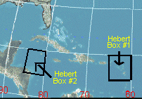
Here is a link explaining the Herbert box.It looks like in a few days Dean should enter this box.Given the history,this maybe very important for people in South Florida to read. http://www.hurricanecity.com/hebertbox.htm
| OUSHAWN |
| (Weather Guru) |
| Tue Aug 14 2007 08:07 PM |
|
|
Looks like the low level and mid level circulations of the the GOM system can't seem to get stacked right and that will keep it from becoming anything but a rain maker. The ULL is still having an effect on it.
| OUSHAWN |
| (Weather Guru) |
| Tue Aug 14 2007 08:25 PM |
|
|
If I'm seeing it correctly, it looks like the GOM system is being pulled in to the same flow as the ULL. You can see that there is now a stream, or line, of moisture from the ULL to the system. It's starting to look more like a trough or something.
| OUSHAWN |
| (Weather Guru) |
| Tue Aug 14 2007 08:31 PM |
|
|
Sure looks like conditions are less favorable than more favorable in the Gulf.
| stormchazer |
| (Storm Tracker) |
| Tue Aug 14 2007 08:34 PM |

|
|
|
Dean is starting to look weak at best and seems to be fighting off an infusion of dry air. Is it possible after all this that Dean may not strengthen much in the short term, or pull a "Chris" and dissipate?
WV Image Central atlantic
| Random Chaos |
| (Weather Analyst) |
| Tue Aug 14 2007 08:38 PM |
|
|
|
|
From what I see, seems like it is almost out of the dry air environment that has been plaguing it for the past 5 days since it left Africa.
http://cimss.ssec.wisc.edu/tropic/real-time/wavetrak/movies/m8g10split/m8g10splitjava5.html
I'd say weakening due to dry air infusion is wishful thinking.
| allan |
| (Weather Master) |
| Tue Aug 14 2007 08:42 PM |
|
|
|
|
Quote:
Dean is starting to look weak at best and seems to be fighting off an infusion of dry air. Is it possible after all this that Dean may not strengthen much in the short term, or pull a "Chris" and dissipate?
WV Image Central atlantic
Dean is not weakening, even mets are saying it is strengthening, I believe it's going through some reorganization like I said earlier. Just because the convection dies out does not mean it's gone, the perosn above said it right, that's wishfull thinkning. It's long before we say goodbye to Dean. I expect a strong TS or even a hurricane tommorrow morning if what I think COULD happen tonight. Lets watch and see what happens, I doubt this would be the end of Dean.
| stormchazer |
| (Storm Tracker) |
| Tue Aug 14 2007 09:00 PM |
|
|
|
|
Do not misunderstand, I am not suggesting Dean WILL dissipate, though it would be ironic considering the model support it has had since before its inception, just that it is struggling a bit. Of course it just went through a D-min and could well refire overnight.
| Storm Hunter |
| (Veteran Storm Chaser) |
| Tue Aug 14 2007 09:04 PM |
|
|
|
|
hmm... the lowest pressure i have seen on the GOM low.... is 1006mb... haven't seen a vortex... not sure if i missed it or not... winds not that bad neither... around 20-25 mph at the surface
| OUSHAWN |
| (Weather Guru) |
| Tue Aug 14 2007 09:08 PM |
|
|
That's because it looks like either the circulation is reforming further to the north or the low level circulation is going one way and the mid level is going another. You can see very clearly in the satellite pics that the circulation of the storms is wrapping further to the north than where the low level center is suppose to be. I'm not an expert on any of this so I don't have a clue as to what this means for the system in the GOM except that it is not going to be classified anytime soon...if at all.
| Rich B |
| (British Meteorologist) |
| Tue Aug 14 2007 09:45 PM |
|
|
Satellite imagery would seem to show that the disturbance over the GOM is becomming somewhat better organised once again. The circulation looks to be elongated along a SW - NE axis, but with some decent banding now setting up. also, there has been quite a flare-up of convection near the centre. If this trend continues then i think we could see this classified some time this evening or tonight. not sure how much longer RECON will be in for, but if they are in for a while they might find hat a centre has finally closed off.
| HanKFranK |
| (User) |
| Tue Aug 14 2007 10:35 PM |

|
|
|
dean is stronger than the advisories are saying, i'd reckon. the low clouds from the exposed eastern side were whipping around pretty good earlier. this afternoon the convection has stopped bursting as strong, but it'll pick back up in an hr or a few. no reason not to. models trending stronger with the ridging, but i'm thinking they're underplaying the later storm and how much it will be reacting to whatever ridge fracture is off the east coast. don't think it's going to stay in the caribbean and not get into the western atlantic, i mean. its faster movement means the threat window for a u.s. hit would be 21-23 august, for florida at least. it's going to run into stuff on the way, wherever in the u.s. it might end up going.
the gulf thing... interesting that they chose not to tag it a depression. if it's a borderline system i would have erred on the side of classifying it. obviously a closed center, obviously some deep convection. i get that it's not a tight center and all... but this thing has the kind of upper support that will cause it to strengthen very quickly once it gets together. don't see the advantage on not putting watches up for the texas coast now as opposed to 10 pm cdt or in a special advisory, or whenever. but yeah, it is marginal. just the same, odds extremely high that it's erin tomorrow.
nuff for now.
HF 2235z14august
| StrmTrckrMiami |
| (Weather Guru) |
| Tue Aug 14 2007 10:46 PM |

|
|
|
Hello,
I am new to this forum, mostly because I have just moved to Miami, Florida (Perrine) from Manchester, NH and I have some experience with tracking storms.
Just a quick question on Dean. When I was viewing the satalite images that were recently updated, I noticed that Dean was predicted to be a Catagory 2 when he hits Haiti/Dominican Republic. Out of curiosity, is it at all possible for Dean to strenghthen when he hits the waters between Cuba and Haiti? If so, could this result in the hurricaine curving twoard Florida? preferably Miami? If someone more experienced could help me on this, because I would like to be prepared, and I have never gone through a hurricaine before.
Thanks
| Random Chaos |
| (Weather Analyst) |
| Tue Aug 14 2007 10:53 PM |
|
|
|
|
Essentially, it is too far out to know both it's track and intensity even when it reaches the Cuba area.
As is, intensity forecasts, the 5-day (Haiti area) range everywhere from a Tropical Storm through a strong Category 4. That's a huge range of possibilities. NHC dropped the outliers and chose the average of those left to come up with a category 2.
As is being discussed in the Forecast Lounge, the track is equally up in the air. One run send it off into the atlantic, the next into texas, the next into the carolinas, and the next into flordia. There is no clue how powerful this is going to be or where it's going after about 2-3 days.
--RC
| Valandil |
| (Verified CFHC User) |
| Tue Aug 14 2007 10:57 PM |
|
|
I agree with HF that they could have just taged it, to get some awareness since it is very close to land an will probalbly be a depression soon.
But atleast the Bouy 42001 agrees with the NHC, it sits almost in the center of 91L. Preasures are falling and the winds are increasing, but wind at 14kts are not enaugh for a depression,yet.
I think it will develop somewhat faily soon before it eventually runs out of time.
Vala
| StrmTrckrMiami |
| (Weather Guru) |
| Tue Aug 14 2007 11:04 PM |
|
|
|
|
Quote:
Essentially, it is too far out to know both it's track and intensity even when it reaches the Cuba area.
As is, intensity forecasts, the 5-day (Haiti area) range everywhere from a Tropical Storm through a strong Category 4. That's a huge range of possibilities. NHC dropped the outliers and chose the average of those left to come up with a category 2.
As is being discussed in the Forecast Lounge, the track is equally up in the air. One run send it off into the atlantic, the next into texas, the next into the carolinas, and the next into flordia. There is no clue how powerful this is going to be or where it's going after about 2-3 days.
--RC
So since no one knows what this hurricaine might do, what is your professional suggestion? In my experience in tracking storms across the New England area, there was one storm that we never saw coming and that was hurricaine floyd, but there was one in the early 90's as well that devistated New England (Perfect Storm) As I am new to this area, I do not know what to do in hurricaines. In New Hampshire we did not have to prepare for these things because they happened on a rare occassion. Over the last few years, New Hampshire has seen some wierd weather impacts, starting with the Mother's day floods in 2006, to the late start of the snow season finally hitting us on Valentines Day, and then again to the April 2006 floods (Which in all three incidences, I was requested to assist in natural disaster stuff with the National Guard) So I guess if no one can tell, not even the storm trackers that have been tracking storms for years, than what should I do? My fiancee seems to think that this storm is no threat to us, but I seem to think otherwise. You see, I think that once this storm crosses through the Haiti/Domincan Republic, I think that this storm will follow along the outside of Cuba, and then once it hits the warm Atlantic/Gulf waters make an aim at Florida. You see, no one in Florida is concerned right now because the meterologists are all telling us different things. This is August, and if this storm is unpredictable now, than how are people in the US suppose to prepare for such a disaster? Does anyone want to help me, because I would like to know if you think this storm is going to be another Andrew?
| Storm Hunter |
| (Veteran Storm Chaser) |
| Tue Aug 14 2007 11:05 PM |
|
|
|
|
for those looking to follow the Hurricane Hunters... i'm looking at a few KML files for recon... that work with the HDOB and other recon msgs... i'll post the link soon.. Pretty neat stuff with sat images loaded over google earth... Kinda like the NAMMA Nasa project last year i posted about... I saw TWC was using it in there last update on the GOM.
| StrmTrckrMiami |
| (Weather Guru) |
| Tue Aug 14 2007 11:08 PM |
|
|
|
|
Quote:
for those looking to follow the Hurricane Hunters... i'm looking at a few KML files for recon... that work with the HDOB and other recon msgs... i'll post the link soon.. Pretty neat stuff with sat images loaded over google earth... Kinda like the NAMM Nasa project last year i posted about... I saw TWC was using it in there last update on the GOM.
Could you please post this link? I am interested in keeping track of this storm
Thanks
| Hugh |
| (Senior Storm Chaser) |
| Tue Aug 14 2007 11:09 PM |
|
|
It's really very strange that the recon flight did not find what is readily visible on visible satellite imagery - that's the nicest way I can put it. I suspect that, due to the fact that they didn't classify the system as a depression at 5pm, they never will - it will reach storm strength soon, if the last several IR images are any indication.
Is the plane staying out there, or has it gone back to Keesler? If it's still out there, maybe they will eventually figure out where the LLC is, and NHC will put up watches and warnings.
| StrmTrckrMiami |
| (Weather Guru) |
| Tue Aug 14 2007 11:13 PM |
|
|
|
|
Quote:
It's really very strange that the recon flight did not find what is readily visible on visible satellite imagery - that's the nicest way I can put it. I suspect that, due to the fact that they didn't classify the system as a depression at 5pm, they never will - it will reach storm strength soon, if the last several IR images are any indication.
Is the plane staying out there, or has it gone back to Keesler? If it's still out there, maybe they will eventually figure out where the LLC is, and NHC will put up watches and warnings.
What are you talking about? Are you simply stating that this is going to be a hurricaine because the recon flight did not find it? Now I am confused lol
| madmumbler |
| (Storm Tracker) |
| Tue Aug 14 2007 11:13 PM |

|
|
|
Quote:
So since no one knows what this hurricaine might do, what is your professional suggestion? In my experience in tracking storms across the New England area, there was one storm that we never saw coming and that was hurricaine floyd, but there was one in the early 90's as well that devistated New England (Perfect Storm) As I am new to this area, I do not know what to do in hurricaines.
You need to find the website for your county's EOC and follow their instructions. You can most likely find a free hurricane guide at any Publix or other grocery store, or call the local TV stations to find out where they're giving them away.
Build yourself a hurricane kit -- you can also find instructions on SFWMD's page at:
https://my.sfwmd.gov/portal/page?_pageid=2854,19644915,2854_19644929&_dad=portal&_schema=PORTAL
They have a lot of links to different agencies.
You should be prepared for EVERY hurricane. Only until EOC and the NHC announces the all-clear for your area should you not pay attention to where it is. I'm not saying board up now, I'm saying use common sense, get the information you need, and get ready. This is the time of year when we'll start seeing potentially dangerous happenings in the tropics.
| richisurfs |
| (Weather Guru) |
| Tue Aug 14 2007 11:17 PM |

|
|
|
Hi April, I've lived in Florida my whole life and I have seen so many storms and if I could say anything at this point it's that it is way too early to call if it's going to be another Andrew. You have to take these seriously and keep your eye on them because they are unpredictable but no one, who knows anything, would ever speculate at this point exactly what type of storm this will be or exactly where it is going to go.
| Hugh |
| (Senior Storm Chaser) |
| Tue Aug 14 2007 11:17 PM |
|
|
Quote:
What are you talking about? Are you simply stating that this is going to be a hurricaine because the recon flight did not find it? Now I am confused lol
No. I'm stating that it's odd that the recon did not find a LLC when one is obviously present (from looking at visible satellite loops). It looks like this system that is not yet organized enough to be a depression is more organized that Dean. The NHC says it is not defined enough to be categorized as a depression, though, but it looks like it is organizing rapidly.
There is a closed circulation, and the Hurricane Hunters have found it, but the wind speeds are not sufficient for classification. Always remember that Recon is a FAR superior tool than Satellite Imagery; what you see, or think you see on sats isn't always there, but recon 99% of the time is solid data. JK
| madmumbler |
| (Storm Tracker) |
| Tue Aug 14 2007 11:20 PM |
|
|
|
|
They just showed a cool graphic on TWC Abrams & Bettes showing the recon flight path back and forth.
| rmbjoe1954 |
| (Weather Master) |
| Tue Aug 14 2007 11:28 PM |

|
|
|
So, as I understand the nature of the Hebert Box, if a hurricane passes through the Hebert Box (E and SE of PR) then more likely than not, the track would most likely curve towards the southeast US. Is there any other significance associated with the Hebert Box? I beleive that in the short term, Dean is tracking to go through this enigma.
Any feedback on any significance?
| Beaumont, TX |
| (Storm Tracker) |
| Tue Aug 14 2007 11:40 PM |
|
|
91L does look to be getting better organized. Maybe classification will come this evening. In any event, south or central Texas may
get a lot of rain.
| Storm Hunter |
| (Veteran Storm Chaser) |
| Tue Aug 14 2007 11:48 PM |
|
|
|
|
i'm looking for that one KML file there using... there is a couple of them out there...
Recon flew at 787 feet for a good few hours, nice cross pattern of flying the system.... but with recent blow up of convection.... i think that we may have a TD soon.
try this one if you have google earth
GE kml
| wxman007 |
| (Meteorologist) |
| Tue Aug 14 2007 11:50 PM |
|
|
When I am speaking to civic and school groups about hurricane preparedness, I ask this simple question:
"If I came over to your house right now and turned off your power and gas and drained your car of gasoline, do you have EVERYTHING you need to survive for at LEAST 3 days without any intervention from anyone?"
If you can't answer yes, then get to the store and get the things you need so that you can.
As far as property preparation, the American Red Cross has a wealth of tips about that on their website.
| WXMAN RICHIE |
| (Weather Master) |
| Wed Aug 15 2007 12:00 AM |

|
|
|
Hebert's box is important to South Florida hurricane history, but it primarily is talking about major hurricanes. If a MAJOR hurricane goes through that box that means it has a very high likelihood of hitting South Florida. So, we need to watch if Dean becomes a major hurricane if and when it might pass through that box.
| Storm Hunter |
| (Veteran Storm Chaser) |
| Wed Aug 15 2007 12:06 AM |
|
|
|
|
Aircraft (AF305) just went on a west to east course... well south of the blow up of convection.... and now are heading SW from the west to east pass... at about 757 feet... winds are about 27mph at flight level... based on what i have seen... i don't think they can close off a center? the new convection is well to the north of where there at right now.... well seen what next HDOB data brings...
Just to show you what i am seeing:
Product: Air Force Tropical RECCO Message (URNT11 KNHC)
Transmitted: 15th day of the month at 00:03Z
Aircraft: Air Force Aircraft (Last digit of aircraft registration number is 305)
Mission Purpose: Investigate fourth suspect area (in the North Atlantic basin)
Mission Number: 1
Observation Number: 28
Observation Time: Wednesday, 00:03Z
Radar Capability: Yes
Aircraft Altitude: Below 10,000 meters
Coordinates: 23.0N 90.5W (View map)
Location: 151 miles (243 km) to the NNW (338°) from Mérida, Yucatán, México.
Turbulence: None
Conditions Along Flight Route: In the clear
Pressure Altitude: 260 meters
Flight Level Wind: 5 knots (~ 5.8 mph) (Bearing was unavailable.)
- The above is a spot wind.
- Winds were obtained using doppler radar or inertial systems.
Flight Level Temperature: 26°C
Flight Level Dew Point: 24°C
Weather (within 30 nautical miles): Broken clouds (5/8 to 7/8 cloud coverage)
Mean Sea Level Pressure (MSLP): 1007 mb (extrapolated)
Estimated Surface Wind Direction: Bearing was unavailable.
Estimated Surface Wind Speed: 5 knots (~ 5.8 mph)
| Unregistered User |
| (Unregistered) |
| Wed Aug 15 2007 12:07 AM |
|
|
looks like dean is weaking dry air intraining the center if this dont filter out dean could be down graded to depression or even a open wave wind shere is also a factor dont look good in the short term good news for everybody
| ftlaudbob |
| (Storm Chaser) |
| Wed Aug 15 2007 12:09 AM |
|
|
|
|
Quote:
So, as I understand the nature of the Hebert Box, if a hurricane passes through the Hebert Box (E and SE of PR) then more likely than not, the track would most likely curve towards the southeast US. Is there any other significance associated with the Hebert Box? I beleive that in the short term, Dean is tracking to go through this enigma.
Any feedback on any significance?
There have been only 2 major hurricans to hit South Florida that did not enter the Herbert box.Wilma went through box #2.Andrew did not enter box #1 but it did skirt it.The numbers don't lie,I always look at the Herbert box.Frances and jeanne in 2004 went through box #1.The good news is if a storm does not go through one of the boxes,it will most likely miss south Florida.Now ,it does not have to be a major cane when it goes through the box.
| Hugh |
| (Senior Storm Chaser) |
| Wed Aug 15 2007 12:14 AM |
|
|
Quote:
Aircraft (AF305) just went on a west to east course... well south of the blow up of convection.... and now are heading SW from the west to east pass...
If they are already well south of the blow up of convection (which on visible imagery looked to be where the LLC was), and now they're heading FURTHER SW, how can they hope to close off a low? They would have to fly NORTH.
|
MikeC
|
| (Admin) |
| Wed Aug 15 2007 12:21 AM |
|
|
Quote:
looks like dean is weaking dry air intraining the center if this dont filter out dean could be down graded to depression or even a open wave wind shere is also a factor dont look good in the short term good news for everybody
It's not going to get downgraded, It's been sheared a little, but man does it have an impressive low level circulation center. As long as it keeps that, it'll re intensify pretty quickly.
The quickscat shows it

It just means if when the shear it's encountering now goes down a bit, it'll flare up quite a bit. If it gets disrupted, it may still yet fall apart, but I wouldn't bet on it. Watch how it persists overnight. Already convection is firing up again near the center of circulation.
| CaneTrackerInSoFl |
| (Storm Tracker) |
| Wed Aug 15 2007 12:24 AM |

|
|
|
Quote:
looks like dean is weaking dry air intraining the center if this dont filter out dean could be down graded to depression or even a open wave wind shere is also a factor dont look good in the short term good news for everybody
First of all, use punctuation. I have very little idea of what you just said. Second of all, convection has begun to blow up around the COC again so wheres your basis?
http://www.ssd.noaa.gov/goes/flt/t1/loop-avn.html
Third of all, Dean is not getting downgraded to an open wave looking like that.
| Storm Hunter |
| (Veteran Storm Chaser) |
| Wed Aug 15 2007 12:28 AM |
|
|
|
|
here you go hugh... just i am going on based on there flight path... they have radar on and they have a better look at the system... but i would expect that there about to wrap up and head in... i bet with one pass through that new convection...
Recon Vortex drops/flight path
| Hugh |
| (Senior Storm Chaser) |
| Wed Aug 15 2007 12:39 AM |
|
|
Quote:
here you go hugh... just i am going on based on there flight path... they have radar on and they have a better look at the system... but i would expect that there about to wrap up and head in... i bet with one pass through that new convection...
Thanks, that helps alot, really, although I would have expected a flight that passed through the western side of the convection... but those details show them passing through where I would have expected the LLC to be. Satellites can be very deceiving apparently.
| OUSHAWN |
| (Weather Guru) |
| Wed Aug 15 2007 12:39 AM |
|
|
I'm confused...how do you not take that flight through the huge blow up of storms when the system is this close to land? It's easy to see that those storms are right over some sort of circulation.
Shawn
Please take all the question asking to the Ask/Tell Forum or use the PM feature from here on in...
| Storm Hunter |
| (Veteran Storm Chaser) |
| Wed Aug 15 2007 12:42 AM |
|
|
|
|
there actually flying through there now... but i would expect them to be heading in soon... FUEL load should make them head in now. They went from directly south of what i think was the center to directly north... through that convection.... **correction on the last pass through what i think would be the center... that got down to about 530 ft.... like a one last look... there back up higher now... and flight level winds are going up! around 35mph
| Storm Hunter |
| (Veteran Storm Chaser) |
| Wed Aug 15 2007 12:52 AM |
|
|
|
|
alright.. just as i posted last msg... looks like there done... heading in for the night until next recon...
**based on HDOB 48**
There at about 5,648 meters (~ 18,530 feet) and doesn't look like they closed off a center? Pretty neat, in about 10 mins from 0035 to 0045z they went from 550ft to 18,550ft... lowest pressure i saw, will check is about 1006mb... and while flying at 600ft, air temp was around 80 degree's.... highest flight level winds i seen were at 35 mph at 1,000ft... (will double check that)
**HDOB 49 puts them at 300 miles due south of New Orleans heading in... at alt. 24k ft.... they have flight level winds coming from the SE at about 30mph... good tail wind heading home?
| Fla. native in Ala. |
| (Registered User) |
| Wed Aug 15 2007 01:13 AM |
|
|
As someone who grew up 20 miles south of Ft. Pierce (and never had a hurricane experience until I moved to Ala. with David, Frederick and Opal), I can tell you this site is invaluable for information on hurricanes. My sister, who lives in Stuart, went through Frances and Jeanne at my house in Montgomery, Alabama. All the TV stations online were predicting landfalls in Vero and West Palm. There were those on this site that predicted both storms would make landfall through the St. Lucie inlet and they were right. My parents and other sister who stayed in Stuart were sorry they did. If they tell you to get out , do it early and just take your laptop and monitor this site. This site is really for professionals who know hurricanes to give the rest of us advice. Just monitor and learn!
| Storm Hunter |
| (Veteran Storm Chaser) |
| Wed Aug 15 2007 01:15 AM |
|
|
|
|
just took a good look at Dean... while convection is coming back, he is still getting hit the NE shear (can see it in IR shots).... notice convection is not banding out... so another 12-24hrs of this, then i think we will see him grow and become better structured... I'm thinking now... based on models and forecast pattern... this is a Caribean system... after that... its too far out to tell... i don't think that weakness between the two ridges will be weak enough to allow him to skip the islands... but the models may change... need another 24hrs worth of runs to see...
as for the GOM... i would expect this to be at TS at landfall.... but not that strong at landfall.... (and atleast a TD by 5am package in the morning)..... the conditions are getting better for it now... the ULL is moving over TX... and the GOM temps ahead are VERY WARM... the ULL was the only thing holding this from becoming a TS in the GOM today.... **(shear)**
| Old Sailor |
| (Storm Tracker) |
| Wed Aug 15 2007 01:32 AM |
|
|
|
|
dean looks the same feel still at 40mph, But think 91L will be TD at 11...
| Thunderbird12 |
| (Meteorologist) |
| Wed Aug 15 2007 01:38 AM |
|
|
Looks like they are going to bump the intensity up to at least 45 kts on Dean for the next advisory, based on the initial intensity used in the SHIPS output linked below:
http://www.srh.noaa.gov/productview.php?pil=WBCCHGHUR
| Storm Hunter |
| (Veteran Storm Chaser) |
| Wed Aug 15 2007 01:41 AM |
|
|
|
|
i would expect to read in the 11 TWO.. since recon has left the system... sats have shown better presentation of the system.... storms are to the NE of what was the center... recon could not close off a center? its right there at a TD.
May just be me... but looks like a lot of the models on Dean are back into the Caribean?
| WeatherNLU |
| (Meteorologist) |
| Wed Aug 15 2007 01:41 AM |

|
|
|
TD5 in the Gulf at the next advisory.
| twizted sizter |
| (Weather Guru) |
| Wed Aug 15 2007 01:42 AM |
|
|
Based on that quikstat image posted Dean definitly looks better than earlier...some 45kt barbs in there as well it appears.
Interested to see what he looks like in the a.m. after the dinural max.NHC has him to be a hurricane at the 2pm Fri position...seems to be on track.
Would hope they would at least issue some warnings for 91L...don't think the winds found in recon waranted an upgrade but I'm sure alot of people aren't really paying attention or even know what an invest is...at least give them a heads up.
Well I stand corrected on the upgrade of 91l
| Storm Hunter |
| (Veteran Storm Chaser) |
| Wed Aug 15 2007 01:47 AM |
|
|
|
|
hmm.... in that NHC run... they went with 1000mb on Dean... so pressure down a bit from earlier...
here's most of the 00z runs with GE... the models are in much better agreement tonight than last night on dean's path... but that could and will change again and again
Both systems models on GE
| CaneTrackerInSoFl |
| (Storm Tracker) |
| Wed Aug 15 2007 01:51 AM |
|
|
|
|
NRL has it up 45 knots and down to 1000 mbs.
Click Here
| wxman007 |
| (Meteorologist) |
| Wed Aug 15 2007 01:59 AM |
|
|
Also has 91L as 05 Noname, so it appears we have TD5.
| OUSHAWN |
| (Weather Guru) |
| Wed Aug 15 2007 02:04 AM |
|
|
Now that we have TD#5 this thing may actually start to really fire off. I've seen it happen before with storms in the GOM. We all know how warm the water is out there and it still has some time left before it hits land. Also, Joe B. has even mentioned this before, tropical systems like to really "go off" when they get close to the Texas coast. There's something about the way the coastline is at an angle that sets them off. I remember Alicia doing that back in '83 as well as Allison when she was just a few miles off the coast in 2001. I'm not saying it will...I'm just saying I wouldn't be surprised.
Shawn
| cieldumort |
| (Moderator) |
| Wed Aug 15 2007 02:10 AM |

|
|
|
I've been of the impression all afternoon that 91L has not been able to consolidate around the original LLC because it has been attempting to reform, or recenter itself, under where the deepest convection has been sustained, which also looks to be, unsurprisingly, where the upper level winds and overall shear has been coming way, way down (LINK)
The entire gulf has seen some cyclonic wind flow about the rough center of the Low, but with this blowup getting even more impressive as we head into the overnight, I tend to agree that TD5 may be called as 11PM. Overall, I put the odds at 80% of 91L becoming an officiated tropical cyclone within the next 48 hours, it just has to consolidate a tiny bit more.
The most recent model run that is closest to what has been my line of thinking is the 18Z NAM (LINK). It plays out the scenario of the cyclone truly centering a bit to the north of where most others have it initialized, and rather than a trip into old Mexico, takes it landfalling as a strong tropical storm or borderline hurricane near Port O Conner, Texas (up the coast a little bit from Corpus).
If I had to pick a cone, I would go with anywhere from Brownsville to Port O Conner, but stressing that the impacts will be felt well-away from the COC, itself. This is an area (SE Texas) which has already seen tremendous flooding so far this summer. Despite the recent past couple of dry days and even weeks, grounds are still soggy, rivers and lakes still at or above normal levels.
EDIT - See what I get for not checking NRL et all before posting?

(Been a long, long day)
| Storm Hunter |
| (Veteran Storm Chaser) |
| Wed Aug 15 2007 02:11 AM |
|
|
|
|
Well expect watches and warnings to be coming out shortly for the Texas coast into MX coast. Just looked at the cloud temps on the GOM... around -80 to -85.... they shot way up into the atmosphere... Nice rapid blow up of convection this evening.... not susprising to me.. the GOM is a bath tub of VERY WARM water now.
| OUSHAWN |
| (Weather Guru) |
| Wed Aug 15 2007 02:28 AM |
|
|
I'm not agreeing with the Northern Mexico/Southern Texas landfall option. I'm thinking more of a Central Texas Coast landfall...say around Corpus.
Shawn
| Storm Hunter |
| (Veteran Storm Chaser) |
| Wed Aug 15 2007 02:32 AM |
|
|
|
|
not sure, but i think TD5 is at 1006mb and at 25kts... lat./long coming with pkg..
just read public adv... TD 5 pkg coming out now
...TROPICAL DEPRESSION FORMS IN THE CENTRAL GULF OF MEXICO...
TROPICAL STORM WATCHES ISSUED...
AN AIR FORCE RESERVE UNIT RECONNAISSANCE AIRCRAFT ESTIMATED A
MINIMUM CENTRAL PRESSURE OF 1006 MB...29.71 INCHES...EARLIER THIS
EVENING.
So they are goin with recon pressure from earlier.... with landfall on thursday morning... southern TX coast
| OUSHAWN |
| (Weather Guru) |
| Wed Aug 15 2007 02:44 AM |
|
|
As of right now, the Houston/Galveston area is not under the watch. I think the watch will be extended further north in time.
Shawn
| Rabbit |
| (Weather Master) |
| Wed Aug 15 2007 02:47 AM |
|
|
|
|
looks like the ULL is pulling west rather rapidly, and is helping to enhance TD5's outflow
also, on NRL, Dean appears to be at 50mph now
| Storm Hunter |
| (Veteran Storm Chaser) |
| Wed Aug 15 2007 02:50 AM |
|
|
|
|
yeah... Pressure down... winds up
Dean is at
TROPICAL STORM CENTER LOCATED NEAR 12.0N 42.3W AT 15/0300Z
ESTIMATED MINIMUM CENTRAL PRESSURE 1000 MB
MAX SUSTAINED WINDS 45 KT WITH GUSTS TO 55 KT.
|
MikeC
|
| (Admin) |
| Wed Aug 15 2007 02:55 AM |
|
|
Clark's got the new model graphics working more consistently now, they are listed on the main page under each storm, but for reference:
The Intensity plot is brand new.
Dean
Dean Latest Model Track image: Latest Static - Animated
Dean Latest Intensity Model Image: Latest Static - Animated
TD#5
TD#5 Latest Model Track image: Latest Static - Animated
TD#5 Latest Intensity Model Image: Latest Static - Animated
Trying to add a few more things as well, but that's a start for tonight.
| Clark |
| (Meteorologist) |
| Wed Aug 15 2007 03:42 AM |
|
|
Many thanks to Mike with the help on mirroring the images. I hope they are of some use to you guys, being more complete than the SFWMD images (and a bit better looking, I think). The full set of images can always be found at http://moe.met.fsu.edu/~acevans/models/ -- including GFS Ensemble model tracks and a "quick look" image showing what is being plotted.
With respect to the tropics...
The structure of Dean, as illustrated by QuikSCAT, is such that as it moves into a region of weaker easterly shear, better thermodynamics (away from all of that stable air near the Cape Verdes), and warmer SSTs, it has a chance to develop at a decent rate. Look for this to happen starting sometime tomorrow -- probably afternoon into evening.
Not a whole lot to change with respect to the forecast reasoning or intensity right now. The NHC track and intensity both look reasonable at this time. From there, it's still largely a crapshoot, but a major hurricane is likely to be somewhere in Hebert's box before the 5 day period is out.
And TD 5? For some reason, I'm getting Dean flashbacks in my mind...except from the 1995 version rather than the 2007 version. What that means is a weak to moderate storm making landfall on the Texas coastline a day or two after it developed with rainfall as its most significant effect. The NHC intensity and track look good, though there's an outside chance at more intensification than anticipated depending upon how much the shear relaxes. The warmest (and deepest) waters of the Gulf are further east, so don't expect a bonanza out of this one.
| cieldumort |
| (Moderator) |
| Wed Aug 15 2007 08:41 AM |
|
|
|
|
A lot of organization still going on with TD5. I've seen somewhat better-organized disturbances go without an upgrade, so it's a little easy to say that NHC may have been gracing this one a little bit. The recent QuikSCAT pass from 08/15 0028Z clearly revealed the original LLC way down near 21N 91W, and still arguably either the dominant or yet major player at the surface. However, that pass also did hint at a the possibility of a very tenuous replacement LLC forming underneath the MLC, and roughly where NHC pegged the approximate center of the broad circulation of the tropical low.
The most recent RUC run I looked at still picks up on the original LLC as being the nexus of TD5, but also forecasts a complete and thorough jumping of the center later today... and that, combined with a continuing favorable atmospheric environment and very warm SSTs still make the recent NAM runs the better bets, IMHO.
Pressures are now starting to fall more, and somewhat more rapidly, while convection is getting its act back together, as well.
Bottom line - deep south and southeastern Texas needs to be prepared for the prospect of widespread moderate to heavy rains, areas of high winds (especially along the coast), isolated tornadoes, and really, most of all.. more flooding.
| WeatherNLU |
| (Meteorologist) |
| Wed Aug 15 2007 10:11 AM |
|
|
|
|
Boy, I tell you as interested as I am trying to be in TD5 since it's closer to home, Dean is starting to scare me a little. Of course it's terribly early to be worrying, but the GFS is starting to hone in on an area that I am not comfortable with, and that's the Louisiana coastline. The NHC is very comfortable with what the GFS is doing with Dean and has shifted the 5AM track southward for a run right through the Caribbean with Jamaica now bearing the brunt of the trouble as opposed to Puerto Rico and the Dominican. Still plenty of time to watch, but I don't like what I am seeing right now with Dean. If the 5 day forecast of the NHC holds as now shown, I see no way how Dean stays out of the GOM. Yuck!
| WeatherNLU |
| (Meteorologist) |
| Wed Aug 15 2007 10:13 AM |
| Attachment |
|
|
|
|
168HR GFS..........not good. BIG HURRICANE in a BAD SPOT. (See attachment).
228HR GFS has a signifigant hurricane making landfall on the Central/Western Louisiana coast. (Valid 08/24).
Obviously just food for thought at this point, the main idea being that a track more through the Caribbean and not north of the islands is taking shape.
| Hugh |
| (Senior Storm Chaser) |
| Wed Aug 15 2007 10:54 AM |
|
|
Quote:
If the 5 day forecast of the NHC holds as now shown, I see no way how Dean stays out of the GOM.
Yuck!
It is *possible* that Dean never makes THE TURN, and plows into Central America. The high in the SE that it giving us this oppressive weather and pushing TD 5 into Texas could keep Dean out of the picture.
Having said that, I don't expect it to - prepare for the worst, and it won't happen, they say. In 3-4 days we should know more, hopefully, but right now I think it's certainly not unreasonable to expect a Cat 3-4 (or higher) hurricane in the central GOM in the long term.
| madmumbler |
| (Storm Tracker) |
| Wed Aug 15 2007 12:02 PM |
|
|
|
|
Quote:
168HR GFS..........not good. BIG HURRICANE in a BAD SPOT.
228HR GFS has a signifigant hurricane making landfall on the Central/Western Louisiana coast. (Valid 08/24).
Obviously just food for thought at this point, the main idea being that a track more through the Caribbean and not north of the islands is taking shape.
Again I say, it doesn't matter where at this point it will hit -- EVERYONE should be making their early preparations at this point, regardless of where they are. THIS is the time to check plywood, window shutters, etc., go to the store, try to start the generator, all of that.
Do NOT wait until the NHC declares a hurricane watch to do all of this. At that point, EVERYONE will be trying to do it. NOW is the time to prepare.
Also, important reminder, if you have pets, make SURE you go through your evacuation plan and have all arrangements in place to ensure their safe evacuation if you leave! Many municipalities/counties are now creating pet-friendly evacuation shelters, BUT usually only for dogs and cats, and you have to have current vet paperwork. DO IT NOW.
Dean is coming SOMEWHERE. So prepare now and if you don't need it, fine.
| OUSHAWN |
| (Weather Guru) |
| Wed Aug 15 2007 12:14 PM |
|
|
Man, sure is hard to believe from looking at the latest satellite pics that we are still talking about a 30mph depression in the GOM. That thing has exploded with deep convection. I think the Hunters are on their way back out to the system. I'll be surprised if they don't find this to be a tropical storm now. I still feel the watches will have to be extended north into the Houston/Galveston area.
Shawn
| stevie |
| (Verified CFHC User) |
| Wed Aug 15 2007 12:44 PM |

|
|
|
I agree with you Shawn about the growth, however I think the National Hurricane center is being careful about scaring the Hou/Gal area since TD #5 has little room left before hitting land. Also the local METS /media seem to be a little behind in the info department.
| LisaC |
| (Weather Watcher) |
| Wed Aug 15 2007 01:13 PM |
|
|
Does anyone know what the coordinates are for the Herbert's boxes?
| h2ocean |
| (Weather Hobbyist) |
| Wed Aug 15 2007 01:27 PM |

|
|
|
Here is a link about the Herbert Box, shows a graphic, but didn't see the actual coordinates.
http://www.hurricanecity.com/hebertbox.htm
Also, I know we have two active systems, but check out the wave behind Dean. It has started to fire some convection around a spinning area.
http://www.ssd.noaa.gov/goes/east/catl/loop-vis.html
| SeaMule |
| (Weather Hobbyist) |
| Wed Aug 15 2007 01:35 PM |

|
|
|
the thing noteworthy to me, and perhaps not mentioned, but additionally not overlooked, I'm sure...is the fact that Dean is slowing down a bit...as he is strengthening.
edited by moderator to remove statements seen as wishcasting
| Beaumont, TX |
| (Storm Tracker) |
| Wed Aug 15 2007 01:37 PM |
|
|
TD 5 does look better this morning. Will be interesting to see what they fine. I was also thinking they might have to extend the
watch to the Houston/Galveston area also. Southeast Texas actually needs rain but of course, no one needs another Allison.
| Random Chaos |
| (Weather Analyst) |
| Wed Aug 15 2007 01:39 PM |
|
|
|
|
We have 2 recons scheduled for the GOM system (TD5) today and 1 recon for it tomorrow.
We have 2 recons scheduled for Dean tomorrow.
----
Quickscat looks impressive for Dean still, but the satellite presentation isn't as good - definately looks to have been affected by some dry air. Even so, Dean has a tightly wound core right now with microwave imagery showing deep convection wrapping most of the way around. I would expect it to make hurricane today.
Meanwhile TD5 looks sheared, with the main convection not over where the quickscat shows the rotation to be located. We need a few more satellite overpasses, though, for other imagery: nothing good for over 6 hours.
----
References:
Quickscat
Microwave imagery: NRL SSMIS overpass 85GHz.
| OUSHAWN |
| (Weather Guru) |
| Wed Aug 15 2007 01:48 PM |
|
|
I'm thinking the circulation on TD#5 may have reformed under all the deep convection. I just can't seem to find what would be causing shear to it.
Shawn
| Random Chaos |
| (Weather Analyst) |
| Wed Aug 15 2007 01:53 PM |
|
|
|
|
I agree.
Nothing should be shearing it, but the deep convection is displaced from the storm center, meaning there is either shear, or the center isn't where it appears to be.
However, that convection that occurred overnight with TD5 looked impressive.
| OUSHAWN |
| (Weather Guru) |
| Wed Aug 15 2007 01:59 PM |
|
|
Well, I guess when RECON gets out there it will hopefully help to clear it up. I wonder if they may find that it has formed a new center under the convection,though. Just speculation on my part I guess.
Shawn
| native |
| (Weather Guru) |
| Wed Aug 15 2007 02:27 PM |
|
|
|
|
Quote:
Does anyone know what the coordinates are for the Herbert's boxes?
Other than the one at the hurricanecity site....this was the best I could find for box 1, I was unable to locate anything similar for box 2. Hope this helps you out.
Herbert's Box
As an aside, I'm not sure how accurate this image is as it looks to be a little larger than the actual box, but, it's a pretty fair assessment. Herbert's box is approximately 335mi. X 335mi. It is 69.2mi. between each degree of both longitude and latitude, which means the box is not quite 5 x 5 longitudinal/latitudinal degrees. (ie 15N to 20N and 60W to 65W.) Technically, the box is 4.84 x 4.84 lonitudinal/latitudinal degrees.
| Ricreig |
| (User) |
| Wed Aug 15 2007 02:28 PM |
|
|
|
|
Quote:There are actually two boxes.
Does anyone know what the coordinates are for the Herbert's boxes?
Box 1 is approx 15N to 20N by 60W to 65W and
Box 2 is approx 15N to 20N by 80W to 85W.
It does appear that Dean will graze one or both of those boxes unless it turns.
| allan |
| (Weather Master) |
| Wed Aug 15 2007 02:38 PM |
|
|
|
|
At 11:00 advisory Dean may very well be very near to hurricane strength. Navy has winds up to 60 mph. (50 knts), this storm is so small in size but wow when you look at the visible, looks liek a minimal hurricane already! With such a small scale storm really gets me thinking about it's potential. The smaller the storm, greater will be the impact, think about Charley in 2004, was a small category 4, done a big amount of damage. Andrew was another one, best example actually, very small category 5 storm, brought the worst damage until Katrina came on board. So really think about Deans potential, I believe a category 5 hurricane is possible in a couple of days, especially as it heads in the GOM
| Thunderbird12 |
| (Meteorologist) |
| Wed Aug 15 2007 02:40 PM |
|
|
The plane has been out in TD5 for awhile now and still no vortex message. I'm not used to interpreting the HD recon obs, but it appears that there may be more than one candidate for a LLC. None of the flight-level winds thus far indicate anything stronger than a depression.
The satellite presentation does seem to be improving, with some banding features noted and also improving outflow. It is running out of time to do anything significant, though, especially considering it's apparent difficulty in establishing a well-defined low-level center.
Update: At 1433 UTC (10:33 EDT), the plane reported flight-level winds of 42 knots, which would be pushing tropical storm strength when the typical wind reduction to the surface is applied.
| Random Chaos |
| (Weather Analyst) |
| Wed Aug 15 2007 03:20 PM |
|
|
|
|
We have a new thread
| sharkman |
| (Registered User) |
| Thu Aug 16 2007 12:54 AM |
|
|
Please people read the summary of the Hebert Boxes

So what does all this mean when a Hurricane passes or develops in the Hebert Box east of Puerto Rico since 1950?
1)N Carolina has as much of a chance to get hit as Florida.
2)20.58% or most go out to sea without hitting land.
3)Only 8.82% make it into the Gulf of Mexico when they pass through the box as a hurricane.
4)Puerto Rico will get hit 20.58% of the time (the highest outside of n Antilles).
What about Box #2,Hurricanes developing or moving through after Oct 1st since 1950?
Cuba & the Bahamas are at highest risk late in the season.
To wrap things up, two significant Hurricanes that hit South Fla did not pass through this box, Andrew 1992, and Betsy 1965!. Data may be slightly off because these boxes were based on data going back to 1900. We chose named storms since 1950 for recognition purposes.
I grew up in Miami from the early 1950's and now live in Tampa Before Andrew which did not go through the Boxes there was nothing for 20 years only in the mid fifties and through the sixties did Miami get hit much less most of the state.
