MikeC
|
| (Admin) |
| Wed Oct 31 2007 01:11 PM |
|
|
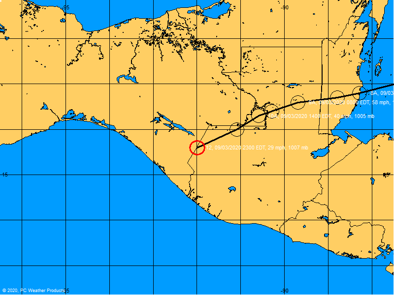
November 1st 9pm EDT Update
As it accelerates to the north and east, Noel has intensified into a minimal hurricane this evening. Current maximum sustained winds are 75mph. No tropical cyclone advisories are up for the US coastline as it is expected to transition into an extratropical storm in the next day or so, but high winds are possible for Cape Cod and the Northeast US as Noel passes offshore Friday into Saturday.
November 1, 2007, 6AM EDT Update
Noel has held at 60mph overnight, pressure has dropped slightly, but Tropical Storm Warnings are now up as a precaution from Ocean Reef to Deerfield Beach, and a Tropical Storm watch north of there to Jupiter Inlet.
Although the storm is expected to pass to the east, the windfield from the storm has expanded enough westward to potentially cause tropical storm force winds along the area in the warning zone.
31/11PM EDT Update
No Tropical Storm Warnings for Florida, Tropical Watches remain from Jupiter inlet southward, however.
Tropical Storm Warnings are up for the Central and Northwestern Bahamas, and a Hurricane Watch has been issued for the northwestern bahamas.
Noel is still expected to move slowly northward, with most of the convection to the north and east of the center. The convection to the north and east of the center has increased quite dramatically tonight.

This site will be continuing to watch this stubborn system.
31/10PM EDT Update
Not much has changed with Noel, other than plenty of people scratching their heads trying to figure out what's really going on with it right now. The good news is that it doesn't look like it's making any more westward movement. The high to the northwest has died down, and so have a lot of the gradient driven winds.

It has some extremely high (cold) cloud tops in the convection east of the center, varied wind, fairly strong, and a highly highly complex environment around it. One of the oddest things I have seen.
31/7PM EDT Update
From the NHC 21Z Bulletin: A TROPICAL STORM WATCH IS IN EFFECT FROM NORTH
OF OCEAN REEF TO JUPITER INLET FLORIDA.
The NHC Discussion noted (correctly) that the center of Noel has been stationary for the last few hours. The Discussion also noted that RECON had detected a secondary center trying to form to the northeast of the primary center. At 23Z the secondary center was located near 23N 78.4W, however for the last couple of hours this secondary center, under the circulation influence of the primary center, has been moving to the west - perhaps even a little south of due west.
Convection is again refiring this evening and some additional strengthening is possible tonight and tomorrow. The models will eventually be correct on the future movement - but Noel is an excellent example of why one should not put all of their marbles in the 'model bag'.
Folks in south Florida need to closely monitor Noel's movement and status.
ED
1PM EDT Update
Latest Recon fix is 22.6N 78.8W, a bit WSW of the 11AM Position of 22.7N 78.5W.
From a Special Weather Statement out of Miami:
Quote:
Due to the complicated nature of the situation. All persons in southeast Florida are urged to stay abreast of the latest advisories and statements from the National Hurricane Center and the Miami Weather Forecast office. And heed the advice of local officials if tropical storm warnings are issued late this afternoon or evening.
What are conditions from Noel and the pressure gradient like in your area? Let us know here
11:50 AM Update
Noel isn't cooperating, the low level circulation appears to be moving away and out of the main circulation.

Too early to tell exactly what this means, more recon data will help, but it should keep everyone alert as to what this system does today.
11AM Update
Noel has strengthened a bit this morning since it has moved off Cuba, and it appears to continue to be strengthening. It is currently at 50MPH winds, with 994 mb pressure, moving north northwest at 8 mph.
There are still no Tropical Storm Watches/Warnings, but there are Gale Warnings out for South Florida. The wind field of Noel may be expanding, and if it does enough, Tropical Storm Warnings may be issued for south Florida.
The forecast track still takes the center over 110 miles east of Florida, over the Bahamas, which do have Tropical Storm Warnings.
Regardless of Gale or Tropical Storm Warnings, it will be a nasty day along the coast, with gradient winds and some beach erosion.
Original Update
Tropical Storm Noel has moved off of Cuba now (Recon last vortex center position was 22.7°N 78.2°W), and is entering the Atlantic, it has a brief opportunity to strengthen today before shear kicks up to the point where the system may weaken again, and it has the potential to strengthen again after it becomes an Extratropical System in the Atlantic. Which means a fair amount of the East Coast (not just Florida) will have to deal with rough surf and gradient winds.

Tropical Storm Warnings are up for the Central and Northwestern Bahamas, there are no Tropical Storm watches or warnings for Florida.
Gradient winds today will, especially in South Florida, likely be brisk, with occasional higher gusts up to gale force. Today is mixed, some of the rain today is not directly from the storm, but some of the lower level clouds may cause some rain and may move west and southwest through the state today.
. Noel's clouds may expand, but the "Wall" keeping it from moving much further west, is also help keeping the convection away from Florida. However, It is possible for some of the western edge of the heavier convection to reach South Florida if Noel strengthens more than expected, so it's still important to watch if you are in South Florida.
It is enough to keep at least those in South Florida watching it closely. It may be a bit rough for Halloween down there, but should be slightly better in Central Florida unless you are right along the coast. Noel will likely pass 110-150 miles east of South Florida, yet this won't mean much because of the indirect winds and beach erosion likely to be caused.

The storm's motion is currently North Northwest, and it's expected to curve more north to northeast during the day. The worst indirectly caused from Noel will be felt in Florida today until late Thursday.
What are conditions from Noel like in your area? Let us know here
For discussion of other, less likely, scenarios check out this thread here.
Radar Loops
Flhurricane Long Term Noel Radar Approach Recording
Large Florida Composite Radar Loop
Large Miami Radar Loop
{{radarlink|mlb|Melbourne FL}}
{{radarlink|jax|Jacksonville FL}}
{{radarlink|amx|Miami, FL}}
{{radarlink|byx|Key West, FL}}
Cuban Radar
RAMSDIS closeup rapid visible satellite animation of Noel
{{CHC}}
{{StormCarib}}
{{StormLinks|Noel|16|16|2007|1|Tropical Storm Noel}}
| weathernet |
| (Storm Tracker) |
| Wed Oct 31 2007 01:19 PM |
|
|
Well, I know the advisory says NNW. Am still not seeing it, and yet to see a clear vis. or RGB sat. that shows clear motion. Cuban radar seems down, and the overall envelope system still appears to be moving WNW. Hard to tell if we are seeing reorganization under the new bursting, or if the true center is dragging WNW, and the convection having moved closer to the center. Net motion for 24 hour period ending at 8:00am this morning has been 1.3 degrees north and 1.4 degrees west.
| cieldumort |
| (Moderator) |
| Wed Oct 31 2007 01:21 PM |

|
|
|
Recon fixed Noel at 995 mb
A most interesting component of this morning's center fix:
Storm NOEL:
Date/Time of Recon Report: October 31, 2007 12:49:20 Zulu
Position Of The Center: 22 ° 42 ' N 078 ° 10 ' W (22.70° N 78.17° W)
-Here-
Maxium Flight Level Temperature / Pressure Altitude Outside The Eye: 21°C (69.8°F) / 1524 Meters
Maximum Flight Level Temperature / Pressure Altitude Inside The Eye: 18°C (64.4°F) / 1524 Meters
|
MikeC
|
| (Admin) |
| Wed Oct 31 2007 01:33 PM |
|
|
Quote:
Well, I know the advisory says NNW. Am still not seeing it, and yet to see a clear vis. or RGB sat. that shows clear motion. Cuban radar seems down, and the overall envelope system still appears to be moving WNW. Hard to tell if we are seeing reorganization under the new bursting, or if the true center is dragging WNW, and the convection having moved closer to the center. Net motion for 24 hour period ending at 8:00am this morning has been 1.3 degrees north and 1.4 degrees west.
This may help:
Here is a good RAMSDIS link to watch for movement with during the day.
Granted this may be more of a reformation of the center since overnight, like what was mentioned in this mornings discussion, but I'll be watching that satellite loop closely over the next few hours to be sure.
The temperature (colder inner core than outer core) difference may be indicating an extratropical transition already starting to occur.
| charlottefl |
| (Weather Hobbyist) |
| Wed Oct 31 2007 01:42 PM |
|
|
I know this violates the rules a little. Can someone help me out I'm supposed to fly into Ft. Lauderdale tomorrow from Guatemala at about 12:30pm.
I was wondering if they've mentioned anything about airport cancellations or anything like that in the area. What effects are expected in Ft. Lauderdale.
Thanks.
| Lee-Delray |
| (Weather Master) |
| Wed Oct 31 2007 01:52 PM |

|
|
|
The airports stay open unless the winds are sustained at 50 mph; which is not expected. The High Wind Warning is due to expire tonight at 6PM; though it probably will be extended. As always, check with the airlines in the morning & be prepared for a bumpy landing.
Weather now is windy and partly sunny. The media seems to be hyping South Florida a lot more than needed. I saw on Yahoo where they are talking about evacutions because of Noel; not true. An old seawall in S. Palm Beach is failing from previous weather and they feel with the current winds (not Noel) the seawall will completely fail. The seawall is for only one condominum on the ocean.
| LoisCane |
| (Veteran Storm Chaser) |
| Wed Oct 31 2007 01:58 PM |

|
|
|
excuse me for wondering here but... from the loops ive seen this morning Noel is intensifying and or... expanding into a larger ball and despite supposed shear it seems rounder and more filled in on the west side
http://www.ssd.noaa.gov/goes/east/natl/loop-rgb.html
as for beach conditions, ill post them elsewhere when I get back from the beach at lunch (a block away on sobe) but...
this has had steady build up of convection and we are talking a storm very close to land and even the slightest shift in track can make a big difference .. even more so combined with change in intensity
difference between hype and playing it safe
http://www.ssd.noaa.gov/goes/east/natl/loop-rgb.html
|
MikeC
|
| (Admin) |
| Wed Oct 31 2007 02:11 PM |
|
|
The "western blowup" is actually closer to the center, the western edge of Noel's center is still exposed. The center recon found was a bit to the west and southwest of the big blowup It'll likely and the center will stay over 110 miles east of South Florida. If you look at the water vapor, the "wall" from yesterday is now more oriented north northeast than north like yesterday afternoon.
The more interesting thing will be any possible extratropical transition (which Recon may have hinted at--I'd still want to see if that continues), and what it does for the general winds and gradient winds. Beach Erosion will likely be Noel's biggest impact on Florida.
I still really don't see any reason for Tropical Storm watches or warnings for Florida, the effects of the system are already covered under the current advisories. This does not mean it won't be an ugly day today and tomorrow morning! Yes it appears close, and I know that makes people nervous, but there's a lot of valid weather reasons not to issue warnings and watches.
|
danielw
|
| (Moderator) |
| Wed Oct 31 2007 02:12 PM |

|
|
|
I am also seeing a slight return of the arc on the western side of the storm.
TWC did their Google map for the Vortex fix and I noticed the RECON center was WSW of the huge convective buildup.
Caution NHC storm movements are based on a 12 hour average.
If it looks like it's moving toward you it probably is.
Remember Hurricane Charley turned at least 3 hours before the NHC upped their direction of motion.
|
danielw
|
| (Moderator) |
| Wed Oct 31 2007 02:22 PM |
|
|
|
|
I don't see where they are getting a hybrid type storm out of the EYE drop.
Temperatures are all in line for a Tropical Storm.
Height of 1000mb: 541m
Temperature / dewpoint at 1000mb: Not recorded / Not recorded
Wind speed and direction at 1000mb: 0kt 0 degrees
----
Surface is at 995mb
Temperature / dewpoint at 995mb: 26.6C / 24.5C
Wind speed and direction at 995mb: 0kt 0 degrees
----
Height of 925mb: 646m
Temperature / dewpoint at 925mb: 22.8C / 20.7C
Wind speed and direction at 925mb: 27kt 185 degrees
----
Height of 850mb: 1385m
Temperature / dewpoint at 850mb: 21.4C / 18.3C
Wind speed and direction at 850mb: 21kt 195 degrees
As best I can tell at this moment. There is more than one RECON flying the storm. It appears that they have done a handoff frrom the St Croix crew to a Keesler Crew.
| doug |
| (Weather Analyst) |
| Wed Oct 31 2007 02:28 PM |
|
|
The structural dynamic of this has certainly improved since yesterday. Took a look at the wide view of this system and the envelope now is huge, and the coverage has a westerly component to it. We will probably have to be patient for several hours to see if NNW is the true direction, or is more related to reorganization. My personal opinion is it is moving NNW, and the reorganization of the mid and low levels has completed.
| LoisCane |
| (Veteran Storm Chaser) |
| Wed Oct 31 2007 02:33 PM |
|
|
|
|
arc on the westside
great explanation
even i could not think how to explain it... good phrase
storm has changed tremendously after it got back in the water and left cuba behind
and the front is there but not the best front i have ever seen
front will get stronger in time but right now... noel looks better than the front
everythings in timing
intensity especially
cant wait to see 11am
|
danielw
|
| (Moderator) |
| Wed Oct 31 2007 02:51 PM |
|
|
|
|
As of 1345Z, 945 AM EDT the water vapor loop is indicating that the western arc of Noel has progressed to a point frfom the Middle of Grand Bahama Island to Cayo Fragoso,Cuba to the 80W longitude line over Central Cuba near Santa Clara, Cuba
http://www.ssd.noaa.gov/goes/east/gmex/img/2007304_1415wv.jpg
http://www.ssd.noaa.gov/goes/east/gmex/loop-wv.html
This is the most western point of the cloud signature in the last two days.
Around midnight last night the western Arc had nearly flattened to a north south line.
http://www.ssd.noaa.gov/goes/east/gmex/img/2007304_0345wv.jpg
| LoisCane |
| (Veteran Storm Chaser) |
| Wed Oct 31 2007 02:54 PM |
|
|
|
|
is it possible that noel is responding to the deepening trough in the gulf to its west... ?
http://www.ssd.noaa.gov/goes/east/natl/loop-rgb.html
storm looks different in a lot of ways
its responding to something
beven did say conditions were favorable for some intensification with his four scenarios
| doug |
| (Weather Analyst) |
| Wed Oct 31 2007 03:05 PM |
|
|
Daniel I also note that the system seems to be having an influence on the trough across Florida., pushig it back a bit. Also the southern most portion of the envelope is expanding its coverages westward. I see the eastern most extent of the approaching trough is in the central gulf coast area between NO and P'cola, and its approach eastward is much more rapid than the storm's approach westward. In other words the race is on...
Yet, there is no real evidence to suggest that the storm will actually diretly effect Florida.
| Steve H1 |
| (Storm Tracker) |
| Wed Oct 31 2007 03:07 PM |
|
|
Pressure dropping pretty rapidly now.....down to 994 mb! The trough is really the one swinging trough the midwest now....that's the kicker. This will be very interesting! WIll they post a TS warning/hurricane watch for SE Florida later today? never know. Happy Halloween!
| LoisCane |
| (Veteran Storm Chaser) |
| Wed Oct 31 2007 03:27 PM |
|
|
|
|
Yeah, in a discussion I found hard to read compared to the excellent one beven did at 5... they seem to feel they may have to issue a warning because we will be experiencing tropical storm winds but it's not really from the storm but from the pressure gradient and they posed the question why... sort of... and referred us to the NWS for more info
After the 11 am discussion I may spend the rest of the day on NWS and here....
Why?
Because if we have tropical storm force winds then it should be issued and not a high wind warning
why? people pay attn to Tropical Storm Warnings.. vs Wind Warnings which they think means "windy"
Why? Does it make a difference if its from a gradient connected to Noel or from Noel directly.. if some palm branch flies into your car window shield while you are driving your child to go halloweening "for just a little while" ...do you care the wind came from the storm itself or the weather associated with the storm..
Words games while the public's interests are not being served...
No one is saying a Cat 2 Hurricane is moving towards South Florida but while this storm intensifies (clearly happening) and expands (definitely) the winds will pick up and people need to know whether to expect kids to go to school tomorrow or drive a long commute into work or take the day off.
After Irene I thought they learned and it doesn't help to go on and update at 1pm after everyone is stuck at work far from home or out in traffic with rising water and rising winds..
and.. I don't care if it's extra-tropical or tropical.. i care what the winds will be and if i will or wont be in their path
| doug |
| (Weather Analyst) |
| Wed Oct 31 2007 03:33 PM |
|
|
Uh, Er!...don't want to be contrary here, but I think we can now just begin to follow on visible the LLC on the SW portion of the convective bubble...pardon me, but that motion is NOT NNW...I go with WNW.
Anybody esle have any opinion?
|
MikeC
|
| (Admin) |
| Wed Oct 31 2007 03:34 PM |
|
|
Yeah it appears the Low Level Circulation is attempting to move out... Now it's MORE exposed than it was a few hours ago.
For those wanting a big wildcard added to the mix, you now have it with this..
Here you can see the 11AM Official position, the Main Convection, and the apparant Low Level Circulation Center moving off to the west, slightly. It's probably best to waiting for some more recon data to really determine what's going on, but strange things are afoot near the Bahamas, Ted.
| Storm Hunter |
| (Veteran Storm Chaser) |
| Wed Oct 31 2007 03:46 PM |

|
|
|
Concur with ur drawing above MikeC.... Although i am curious if its the true low level center... need a little more data on it... but its sure can spinning out to the wnw from the deep convection
| craigm |
| (Storm Tracker) |
| Wed Oct 31 2007 03:47 PM |

|
|
|
Sure enough, Noel seems to have more of a westward component and we know its not strong enough to be stair stepping. Approaching 79W now. I was sure it was starting the hard right turn but now how far west will he get, He has already overshot the forecast track. If indeed, like Storm Hunter points out, that is the LLC.
http://www.ssd.noaa.gov/goes/flt/t1/loop-rgb.html
| Lamar-Plant City |
| (Storm Tracker) |
| Wed Oct 31 2007 03:52 PM |

|
|
|
That is absolutely wild...went to that satellite site and zoomed in on the area....an almost prefectly circular feature moving out from under the large convective burst!! Is this because the shear/trof is in the mid/upper levels and is not affecting the LLC as much? AND is this what they mean by Noel becoming 'extra-tropical' if it loses its LLC at the surface? What would it take for the LLC to develop convection and a life of its own? I am still planning a big camping trip for Fri-Sun on the north side of Tampa and this may change ALL of that.
| Colleen A. |
| (Moderator) |
| Wed Oct 31 2007 03:53 PM |

|
|
|
I am seeing the same thing...but I'm not sure if it's been jumping because I haven't really been following the loops, just TV! However, I trust your judgement!
All I know from the past is this: NEVER say NEVER when it comes to a storm. Of course, the mets on TV say "not to worry about it" while in the same breath say "keep a close eye on it". I think that is always interesting, no? Ugh

| LoisCane |
| (Veteran Storm Chaser) |
| Wed Oct 31 2007 04:05 PM |
|
|
|
|
Thanks for the great graphics and yes...something is going on, very much so and i see more of a westward component than the 11am talked about ... and considering the 5am talked on 4 scenarios it would seem to be that before Noel goes out to sea...he can do a whole lot more damage than one would have thought yesterday at this time.
Something is happening and I'd like some explanations.
A much better sat presentation of the storm as a whole despite the inner workings or whereabouts of the LLC.
I don't really care if its extra-tropical, sub-tropical or tropical.. i care if it is going to get stronger and where it's going.
one complain i have had consistently with the nhc is not track forecast but timing... they are always off on timing
and timing is more important for how it relates to intensity forecasting.. which proenza wanted to improve and needs improving
everyone in miami wanted to know if we would get hit by Noel on Wednesday and I kept telling them Thursday was the day to worry on not WEdnesday
What a difference a day makes....
| Lee-Delray |
| (Weather Master) |
| Wed Oct 31 2007 04:08 PM |
|
|
|
|
Lois
I think the reason they are calling it a High Wind Warning and not a Tropical Storm Watch is actually a legal issue. For a High Wind Warning no one has to close their busness', but a TS warning I think you have to. The municipalities would also have to use their EOC's as well. It's very expensive and inconvenient for 40 mph winds and an inch or so of rain. Also, a TS warning tends to create a panic.
Everyone keeps speaking of Charlie. Punto Gorda was in the 3 day cone and under a Hurricane Warning. Punta Gorda was also on the east side of a hurricane, wher SF is on the west side of a TS.
I think the NHC is doing the right thing, for now. They are saying a TS Warning may come.
| cieldumort |
| (Moderator) |
| Wed Oct 31 2007 04:10 PM |
|
|
|
|
I suspect that LLC is a little too large and spinning around a little too rapidly and coming from just the too perfect starting point to not be "the real deal." Now doesn't this development toss a whole new wrench in the mix. The 11AM forecast is possibly bust, not within one hour after issuance. Should this be the case, now one of two things have to happen to make the 11 happen: A) A -brand new- LLC needs to form within a new powerful convective burst (which doesn't appear to be happening anytime soon, as pressures are now rising per latest recon data and all-too-obvious cloud top warming is underway) or B) The "real deal" LLC and the MLC and its associated now waning deep convection have to meet back up and go through the whole re-coupling process all over again. Either way, it is not nearly as probable that both the 11AM's intensity and track verify as a result.
| scottsvb |
| (Weather Master) |
| Wed Oct 31 2007 04:40 PM |
|
|
Hold on everyone..lets not get to into the west jog..afterall most of the globals had this going to 79-80W before a turn late this evening into tonight...only the GFDL and HRW had this going straight NNW to NE. The Midlevel moisture is feeling the affect of the westerlys and weakening the system slightly over the last few hours pulling Noels LLC WNW but I feel its just a jog as it will turn back NNW then N later this evening. As said yesterday furthest I see this gets is near 80W but felt 78.5-79W was a best best. Now with the LLC jogging WNW the past few hours..it may make it alittle closer but still the turn was forecasted by the globals to begin this evening while the gfdl and few others said last night. Really its still on the GFS forecast.
| Stormin_thru |
| (Registered User) |
| Wed Oct 31 2007 04:48 PM |
|
|
Hello all,
I've been on this site watching and learing from everyone for some time now. I just wanted to take a minute to point out some of you may be overlooking from the 11am NHC discussion.
"ALTHOUGH THE GLOBAL MODELS ARE NOT IN
GOOD AGREEMENT ON THE EVOLUTION OF THE CURRENT SURFACE CIRCULATION
OF NOEL...THEY ALL TAKE EITHER NOEL OR A NEW EXTRATROPICAL
DEVELOPMENT RAPIDLY NORTHEASTWARD"
| Hurricane29 |
| (Weather Guru) |
| Wed Oct 31 2007 04:50 PM |

|
|
|
| doug |
| (Weather Analyst) |
| Wed Oct 31 2007 04:50 PM |
|
|
WOW!...For a minimal TS the circulation coverages of this system are enormous!...Look at the current visible from the NOAA site on the West ATL view. The low level circulation around what is clearly the focus of Noel is huge...I don't think I've ever seen any thing like this.
| Storm Hunter |
| (Veteran Storm Chaser) |
| Wed Oct 31 2007 04:51 PM |
| Attachment |
|
|
|
|
that looks to be the center.... here's recon flight path as of 11:45am
and Doug
Quote:
WOW!...For a minimal TS the circulation coverages of this system are enormous!...Look at the current visible from the NOAA site on the West ATL view. The low level circulation around what is clearly the focus of Noel is huge...I don't think I've ever seen any thing like this.
I think its more typical October.... late season storm.... we got a lot of factors in place... High Pressure, Low Pressure, Trough coming... that the large area doesn't really susprise me.... but this make for a tricky forecast... which most of the models are doing okay right now.... its not an exact science, but the forecast is looking good... been a few minor adjustments made, but for some of us, its been expected.... Shear is the next big factor for Noel i think.... before it gets beat up with the coming front.
|
MikeC
|
| (Admin) |
| Wed Oct 31 2007 04:52 PM |
|
|
Yeah, my best guess for the center position based on visible and radar, now is about 79.0W, but it appears to be moving a bit more northward now too. Will wait for 2PM or so to see if it's a real trend or not.
It adds a bit to the mix, but I don't think it's going to cause a huge change.
edit: Latest recon shows 22.6N 78.8W, a bit WSW of the 11AM Position.
| Hurricane29 |
| (Weather Guru) |
| Wed Oct 31 2007 04:57 PM |
|
|
|
|
Special Weather Statement
SPECIAL WEATHER STATEMENT
NATIONAL WEATHER SERVICE MIAMI FL
1242 PM EDT WED OCT 31 2007
FLZ068-071>074-168-172>174-312100-
COASTAL BROWARD COUNTY-COASTAL MIAMI-DADE COUNTY-
COASTAL PALM BEACH COUNTY-FAR SOUTH MIAMI-DADE COUNTY-
INLAND BROWARD COUNTY-INLAND MIAMI-DADE-METRO BROWARD COUNTY-
METRO PALM BEACH COUNTY-METROPOLITAN MIAMI DADE-
1242 PM EDT WED OCT 31 2007
...SOUTH FLORIDIANS SHOULD MONITOR THE LATEST ON NOEL...
TROPICAL STORM NOEL HAS EMERGED OFF THE NORTH CENTRAL COAST OF CUBA
TODAY...AND DATA FROM HURRICANE HUNTER AIRCRAFT LATE THIS MORNING
INDICATE THAT NOEL HAS STRENGTHENED. MAXIMUM SUSTAINED WINDS ARE NOW
NEAR 50 MPH WITH HIGHER GUSTS. NOEL WAS MOVING IN A GENERAL NORTH TO
NORTHWEST DIRECTION AT 8 MPH. THE AIRCRAFT DATA ALSO INDICATED
TROPICAL STORM FORCE INCREASING SLIGHTLY IN THE NORTHWEST QUADRANT.
NOEL IS FORECAST TO MOVE ON A GENERAL NORTHERLY TRACK TODAY AND
TONIGHT...WITH ADDITIONAL STRENGTHENING EXPECTED.
IF THE TREND OF INCREASING WINDS IN THE NORTHWEST QUADRANT OF THE
STORM CONTINUES THIS AFTERNOON...PORTIONS OF SOUTHEAST FLORIDA
WOULD POSSIBLY BE CLOSER TO THE WINDS ASSOCIATED WITH THE INNER
CIRCULATION OF NOEL TONIGHT AND EARLY THURSDAY. AS A RESULT...A
TROPICAL STORM WARNING MAY BE NEEDED FOR PARTS OF SOUTHEAST FLORIDA
LATER THIS AFTERNOON OR EVENING.
THE STRONG WINDS OF THE PAST TWO DAYS ACROSS SOUTH FLORIDA HAVE BEEN
ASSOCIATED WITH THE PRESSURE DIFFERENCE...OR GRADIENT...BETWEEN A
STRONG HIGH PRESSURE OVER THE MID ATLANTIC STATES AND TROPICAL
STORM NOEL TO THE SOUTH. THE WINDS ARE EXPECTED TO DECREASE OVER
SOUTH FLORIDA THIS EVENING AS THE HIGH WEAKENS. NEVERTHELESS...THE
POTENTIAL EXISTS FOR ANOTHER INCREASE IN WINDS LATER TONIGHT OR
EARLY THURSDAY AS THE WINDS DIRECTLY ASSOCIATED WITH NOEL APPROACH
SOUTHEAST FLORIDA.
DUE TO THE COMPLICATED NATURE OF THE SITUATION...ALL PERSONS IN
SOUTHEAST FLORIDA ARE URGED TO STAY ABREAST OF THE LATEST
ADVISORIES AND STATEMENTS FROM THE NATIONAL HURRICANE CENTER AND THE
MIAMI WEATHER FORECAST OFFICE...AND HEED THE ADVICE OF LOCAL
OFFICIALS IF TROPICAL STORM WARNINGS ARE ISSUED LATER THIS
AFTERNOON OR EVENING.
STAY TUNED TO NOAA WEATHER RADIO AND OTHER LOCAL MEDIA FOR FURTHER
DETAILS OR UPDATES.
$$
MOLLEDA
| Hurricane29 |
| (Weather Guru) |
| Wed Oct 31 2007 05:03 PM |
|
|
|
|
Looks like 50-70kt windshear just north of Noel.
Maybe also be associated with its outflow.
| scottsvb |
| (Weather Master) |
| Wed Oct 31 2007 05:21 PM |
|
|
I think Noel is slowing some...drifting still WNW along the coast (just off shore near 78.9W). 1 thing to look at is the NAM...it wants to keep Noel more West and most of the energy get pulled NE by a developing NON-Tropical Low.. ...now this situation isnt out of the question cause the Globals want to take something NE and they assume its Noel due to its approx to that area.....we might just have a weak low going around cuba.. but then again...its the NAM model (though it hasnt done that bad with this soo far). Ill still go with the GFS.
| doug |
| (Weather Analyst) |
| Wed Oct 31 2007 05:56 PM |
|
|
I agree with what you are saying...and the displacement from the convection is logiically shear related...looks like several things happening simultaneously...probably one of the most complex systems I have enjoyed observing.
| Hurricane29 |
| (Weather Guru) |
| Wed Oct 31 2007 06:03 PM |
|
|
|
|
2pm.
NOEL DRIFTED WESTWARD DURING THE PAST FEW HOURS...BUT IS CURRENTLY
NEARLY STATIONARY. A TURN TO THE NORTH IS EXPECTED LATER TODAY.
| scottsvb |
| (Weather Master) |
| Wed Oct 31 2007 06:04 PM |
|
|
The GFS has been right on most of the time on this. Alittle too far to the south yesterday..but still showed it getting to near 79W and then stoping or/and then turning NE. Still I see this happening. I wouldnt throw out the NAM but I cant go with that model over the GFS with tropical systems. LOL!
| ftlaudbob |
| (Storm Chaser) |
| Wed Oct 31 2007 06:51 PM |
|
|
|
|
I would like to get some feed back about the storm stalling.Could this mean it will have more time to strengthen,and maybe change course?Looks like the NHC will put out warnings for South East Florida late today.This storm would drive anyone crazy!
|
danielw
|
| (Moderator) |
| Wed Oct 31 2007 06:59 PM |
|
|
|
|
With Noel... I mean No-end, anything is possible.
Yes a slowing or stalling would probably mean an increase in the wind speeds and a drop in the pressure. After all, the Gulf Stream passes through the Florida Straits.
|
MikeC
|
| (Admin) |
| Wed Oct 31 2007 07:11 PM |
|
|
It's not likely to strengthen all that much, shear dramatically goes up west and north of where the center is, that's what is probably keeping most of the convection off the center right now.
| Lamar-Plant City |
| (Storm Tracker) |
| Wed Oct 31 2007 07:23 PM |
|
|
|
|
Is it my imagination, or has that low level center gone almost stationary right now. Just off the norther coast of Cuba at about 22.5N and 79W. Could this mean it is about to spin back and rejoin the convection? Or is it 'waiting' for the convection to catch up to it? Storm doesn't look too healthy at this point in the day...very lob-sided because of the shear and the 'wall' it is up against.
| doug |
| (Weather Analyst) |
| Wed Oct 31 2007 07:45 PM |
|
|
"No-End" indeed..look at the new convection just NE of the stalled LLC...the shear across the tops of the convection that was close by this morning but is now seperated a bit seems to be from the WNW..., Am I right? If so what is the source?
| cieldumort |
| (Moderator) |
| Wed Oct 31 2007 08:03 PM |
|
|
|
|
Fawning over models and defending their value in forecasting Noel's track aside for the moment, the facts on the ground are entirely challenging the NHC forecasters, giving them quite the run for the money, one can be sure. After defying the forecast of a continued NNW track so far today, and clearly running WSW, Noel has taken up nearly stationary right along the coast again (Close-up of GOES visible from NRL) . If Noel were to start heading WSW again he will be back over Cuba, once again. In fact, if his mean movement takes up any direction other than a solid NW through E course, he will be back over Cuba. A trip back over Cuba changes everything with regard to the 11AM forecast put out by NHC, not just a little bit of everything.
That paragraph being my segue into getting back to the models. I actually think the very large cyclonic envelope that has grown up around Noel to be illuminating, and something that perhaps lends a good deal more support to the outlier NAM. For several runs now, NAM has held back the bulk of Noel's abundant vorticity this side of 23N, in one fashion or another. NAM has generally taken the large and expansive cyclonic flow that is apparent with Noel, and used that, along with a not nearly as impressive shortwave approach and Noel's anticyclone aloft, to soften the blow and reduce the tugs of the approaching trough. And you know, if you look at the loops today, you really can make a case for this.
Whether or not Tropical Storm Watches and/or Warnings go up for the Keys and/or coastal south Florida, while a matter or politics and economics, is also really a matter of semantics when it comes down to a number of the effects this area continues to feel, and will likely feel, for some more time to come. A High Wind Watch, if reissued, is nothing to scoff at. Sustained winds of up to "only" 40MPH and/or gusts aoa 58, if verified, will definitely rearrange ones view.
| doug |
| (Weather Analyst) |
| Wed Oct 31 2007 08:20 PM |
|
|
Believe it or not I just gave this speech to my office manager, as we discussed the weather and possible effects over the next day or so...I'm in Ft Myers, and a few more hours of WNW means a lot to us here...I agree Gale Center or TS is really not a meaningful distinction right now.
| ftlaudbob |
| (Storm Chaser) |
| Wed Oct 31 2007 08:35 PM |
|
|
|
|
Take a look at the spin now!Could that be an eye forming on the last frame?It is right were the LLC is.
http://www.ssd.noaa.gov/goes/flt/t1/loop-vis.html
| Lee-Delray |
| (Weather Master) |
| Wed Oct 31 2007 08:37 PM |
|
|
|
|
..
.NOEL LINGERING ALONG THE CUBAN COAST...TROPICAL STORM WATCH
WTNT31 KNHC 312032
TCPAT1
BULLETIN
TROPICAL STORM NOEL ADVISORY NUMBER 17
NWS TPC/NATIONAL HURRICANE CENTER MIAMI FL AL162007
500 PM EDT WED OCT 31 2007
...NOEL LINGERING ALONG THE CUBAN COAST...TROPICAL STORM WATCH
ISSUED FOR THE SOUTHEAST FLORIDA COAST...
AT 5PM EDT...2100Z...A TROPICAL STORM WATCH IS IN EFFECT FROM NORTH
OF OCEAN REEF TO JUPITER INLET FLORIDA. A TROPICAL STORM WATCH
MEANS THAT TROPICAL STORM CONDITIONS ARE POSSIBLE WITHIN THE WATCH
AREA.
| Lee-Delray |
| (Weather Master) |
| Wed Oct 31 2007 08:42 PM |
|
|
|
|
From the 5:00 Discussion, now I understand why they held off; makes perfect sense.
WINDS ASSOCIATED WITH THE ENVIRONMENTAL PRESSURE GRADIENT HAVE
DECREASED BELOW GALE FORCE ALONG THE SOUTHEAST FLORIDA COAST.
RECONNAISSANCE DATA INDICATE THAT THE WIND FIELD OF NOEL HAS
EXPANDED IN THE NORTHWEST QUADRANT...AND THE OFFICIAL FORECAST NOW
BRINGS TROPICAL STORM WINDS TO NEAR THE SOUTHEAST FLORIDA COAST.
SINCE ANY SUBSEQUENT INCREASE IN WINDS AT THE COAST WOULD BE
ASSOCIATED WITH THE TROPICAL STORM...A TROPICAL STORM WATCH IS
BEING ISSUED AT THIS TIME. WHILE A WATCH IS USUALLY ASSOCIATED WITH
A LONGER LEAD TIME THAN A WARNING...IT ALSO CONVEYS THE
POSSIBILITY...AS OPPOSED TO THE EXPECTATION...OF TROPICAL STORM
CONDITIONS. BECAUSE THE TROPICAL STORM FORCE WIND RADII ARE
FORECAST TO REMAIN OFFSHORE...A WATCH IS MORE APPROPRIATE THAN A
WARNING. THE NEED FOR A WARNING WILL BE REASSESSED THIS EVENING.
| doug |
| (Weather Analyst) |
| Wed Oct 31 2007 08:53 PM |
|
|
To comment on the report of the progress of the SW'ly wind zone progressing across the central GOM indeed it has...that is available on the W. ATL WV LOOP.
Impressive progress today while the center has stayed stationary...
The NHC said the center may be making a cyclonic loop, but in the last frames of the most recent visible image I noticed a significant jump ENE. Will have to watch for an hour or so to see if it is a movement or a loop.
| Storm Hobbyist |
| (Registered User) |
| Wed Oct 31 2007 08:56 PM |
|
|
|
5PM:
WINDS ASSOCIATED WITH THE ENVIRONMENTAL PRESSURE GRADIENT HAVE
DECREASED BELOW GALE FORCE ALONG THE SOUTHEAST FLORIDA COAST.
RECONNAISSANCE DATA INDICATE THAT THE WIND FIELD OF NOEL HAS
EXPANDED IN THE NORTHWEST QUADRANT...AND THE OFFICIAL FORECAST NOW
BRINGS TROPICAL STORM WINDS TO NEAR THE SOUTHEAST FLORIDA COAST.
SINCE ANY SUBSEQUENT INCREASE IN WINDS AT THE COAST WOULD BE
ASSOCIATED WITH THE TROPICAL STORM...A TROPICAL STORM WATCH IS
BEING ISSUED AT THIS TIME. WHILE A WATCH IS USUALLY ASSOCIATED WITH
A LONGER LEAD TIME THAN A WARNING...IT ALSO CONVEYS THE
POSSIBILITY...AS OPPOSED TO THE EXPECTATION...OF TROPICAL STORM
CONDITIONS. BECAUSE THE TROPICAL STORM FORCE WIND RADII ARE
FORECAST TO REMAIN OFFSHORE...A WATCH IS MORE APPROPRIATE THAN A
WARNING. THE NEED FOR A WARNING WILL BE REASSESSED THIS EVENING.
Anyways, I'm still staying firm on the fact that Noel will not do what NHC is thinking its going to do...
I mean,honestly, they have been wrong this WHOLE time...

The turn to the north is inevitable, of course, but its all about when. The NHC has been wrong about this "when" for awhile now.
| Colleen A. |
| (Moderator) |
| Wed Oct 31 2007 09:01 PM |
|
|
|
|
I'm not sure that's an eye forming, Bob. I suppose it could be an indication that the storm is re-organizing itself and that perhaps the LLC is deepening a bit...if the pressure begins to fall on Noel, this might be the case.
On the other hand, I could be completely off base and have no clue!
| Colleen A. |
| (Moderator) |
| Wed Oct 31 2007 09:13 PM |
|
|
|
|
Easy...the NHC has not been wrong the WHOLE time on this. We are dealing with a tropical system which went over land and re-emerged just a few hours ago into the Atlantic. This land interaction almost always has an effect on a tropical system; it can split it apart, disrupt it, create a new LLC or fall apart altogether. There are other issues you have to look at also. Timing with fronts, troughs, etc. can always effect a storm and hasten up a forecast or slow it down and the NHC has no control whatsoever over that, so they cannot be blamed.
I know it may not seem like it right now, but in my years of following NHC they have been more right than wrong and time will tell what happens with Noel.
| weathernet |
| (Storm Tracker) |
| Wed Oct 31 2007 09:52 PM |
|
|
Alan - you made no reference yesterday or last night with regards to your "steering current maps" of a stationary motion today. The maps "are" pretty though. It is but one tool, among many however one really need to examine the real weather. Remember too, even GFS and NAM both show surface, mid level, and upper air, but not as an identical interpretation. I am the first to admit to being a map and model monger, however I feel to get a proper read of the weather, one must spend at least as much looking at the "real picture". This picture being the satellite views. Often time models depict something that may simply not be there, where at least the naked eye can make such observations.
I believe we are seeing a cyclonic loop, but not a NE motion. Is basically stationary, but will likely continue to drift NW. I do believe we will see deepening during the evening hours.
| LoisCane |
| (Veteran Storm Chaser) |
| Wed Oct 31 2007 10:55 PM |
|
|
|
|
i believe we dont know for sure what we are seeing... hard to say for sure and don't think anyone knows
either way its very close to south florida and has moved further west than we thought
a lot could happen, norcross showed several scenarios
i think the watch was a prudent step, a little late but a good compromise
nice to think its a loop, could be weak steering currents and what i dont understand is if the front is as strong as the gfdl thought...why are the currents so weak?
i dont see a cyclonic loop.. i see a slow, steady drift west
http://www.ssd.noaa.gov/goes/flt/t1/loop-vis.html
| Tak |
| (Weather Watcher) |
| Wed Oct 31 2007 11:34 PM |
|
|
Looks to me like Noel is about to get a diet of dry air http://www.ssd.noaa.gov/goes/east/watl/loop-wv.html and about 30+ kts of wind shear http://cimss.ssec.wisc.edu/tropic/real-time/atlantic/winds/wg8shr.html
I dont think it can move west against this.
| jessiej |
| (Weather Watcher) |
| Wed Oct 31 2007 11:40 PM |
|
|
Radar from Cuba
http://www.met.inf.cu/asp/genesis.asp?TB.../cmwMAXw01a.gif
|
Ed Dunham
|
| (Former Meteorologist & CFHC Forum Moderator (Ed Passed Away on May 14, 2017)) |
| Wed Oct 31 2007 11:48 PM |
|
|
I've placed a short update on the Main Page. It may help to clarify some items in the latest NHC Discussion. A stationary system should hint at just how weak the steering currents are at the moment.
Regarding NHC: A couple of days ago in an update I stated that the future track was still tbd. Please remember that NHC does not have this luxury when the forecast time pops up every 6 hours.
ED
| Hurricane29 |
| (Weather Guru) |
| Thu Nov 01 2007 12:02 AM |
|
|
|
|
8pm National Hurricane Center Advisory...
NOEL HAS BEEN DRIFTING NORTHWARD FOR THE LAST SEVERAL HOURS AND A
GENERAL SLOW NORTHWARD MOTION IS EXPECTED TO CONTINUE DURING THE
NEXT 24 HOURS.
DATA FROM THE NOAA RECONNAISSANCE PLANE INDICATE THAT MAXIMUM
SUSTAINED WINDS HAVE INCREASED TO NEAR 60 MPH...95 KM/HR...WITH
HIGHER GUSTS. SOME STRENGTHENING IS POSSIBLE DURING THE NEXT 24
HOURS.
|
Ed Dunham
|
| (Former Meteorologist & CFHC Forum Moderator (Ed Passed Away on May 14, 2017)) |
| Thu Nov 01 2007 12:22 AM |
|
|
Note that the above post was from the 8PM NHC Intermediate Public Advisory. Just a general reminder to quote your source. Also note that it is okay to post an extract from any NHC bulletin - but only if you are using it to support a particular point of view since NHC bulletins are always available as drop-down items on the Main Page.
I'd hazard a guess that the primary center might be drifting northward to align itself with the secondary center - but its also possible that the trough to the west is finally exerting its influence on the entire system. A faster forward speed on the 03Z bulletin would provide good verification of this.
ED
| LoisCane |
| (Veteran Storm Chaser) |
| Thu Nov 01 2007 12:37 AM |
|
|
|
|
northward at NEAR 2 mph
what is that 1 and a half miles per hour forward speed
intensity is more impt here than direction at that forward speed
up to 60mph... we aren't getting that far from hurricane force and intensification is in the forecast
in weak steering currents over warm water there is a bigger point here than if noel is or isnt moving n at NEAR 2mph
and more so his western side has seemed to grown and ooze west at at least 2mph i think
| LoisCane |
| (Veteran Storm Chaser) |
| Thu Nov 01 2007 12:39 AM |
|
|
|
|
interesting point Ed made and i would think tho that if that were happening
we would see a storm that has more of a chance to intensify faster, lets hope not considering its so close in right now
"primary center might be drifting northward to align itself with the secondary center "
i mean that could definitely help pull it together
|
danielw
|
| (Moderator) |
| Thu Nov 01 2007 12:54 AM |
| Attachment |
|
|
|
|
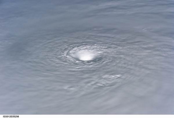
Convective tower near center is spiking well into the Maximum satellite signal. I don't recall seeing this color used before.
Just south of Andros Island, inside the bright red are is a small white area with a black 'dash' in it.
I have no way of estimating the altitude or the cloud top temperatures. These colors are actuall one or two levels higher than Noel displayed prior to crossing over Haiti.
http://www.ssd.noaa.gov/goes/east/gmex/img/2007305_0015rb.jpg
I have attached the 'rainbow enhancement' shot to this post.
It also appears on the Funktop enhancement as a white area on the green level.
http://www.ssd.noaa.gov/goes/east/gmex/img/2007305_0015ft.jpg
| LoisCane |
| (Veteran Storm Chaser) |
| Thu Nov 01 2007 12:56 AM |
|
|
|
|
yeah, that storm is going through a real organization spurt
the trough is there.... not as impressive tonight at noel
i see... we'll see what they say at 11..
i just dont see northward anything... drifting around, stationary more like it and intensifying
over still warm water
|
danielw
|
| (Moderator) |
| Thu Nov 01 2007 01:28 AM |
|
|
|
|
Something very strange going on with the SFMR measuring the surface windspeeds.
It appears that they may have encountered a low level jet stream. Or possibly a strong shear line.
Numbers in bold are the SFMR estimated surface wind speed in knots.
010730 2532N 08115W 3760 08020 0402 -209 -370 274028 028 010 005 00
010800 2530N 08114W 3761 08018 0403 -210 -350 273027 028 044 000 00
010830 2528N 08112W 3759 08021 0403 -209 -370 273026 026 056 000 00
010900 2526N 08110W 3751 08038 0404 -212 -358 275026 026 096 000 00
010930 2524N 08108W 3755 08032 0405 -210 -352 276026 026 142 000 03
011000 2522N 08107W 3766 08011 0404 -210 -348 278026 026 142 000 03
011030 2520N 08105W 3760 08022 0404 -210 -347 279025 025 140 000 00
011100 2519N 08103W 3768 08009 0405 -209 -351 281025 026 133 000 03
011130 2517N 08102W 3818 07916 0405 -202 -336 286023 024 095 000 03
011200 2515N 08100W 3937 07688 0393 -183 -303 295018 020 125 000 03
011230 2513N 08059W 4054 07469 0380 -164 -271 301016 016 087 000 03
Area of peak wind speeds would have been over Ponce de Leon Bay in the Everglades Nat'l Park.
| cieldumort |
| (Moderator) |
| Thu Nov 01 2007 01:41 AM |
|
|
|
|
Yeah, this is definitely much more like what you are more likely to see in some of the juicier West Pac tropical storms, to be sure. I've seen a few of the east pac systems flare this deep, but very infrequently.
Noel was doing this earlier this morning, before the LLC exited stage left. HERE are the AMSU Radial/Height cross section anomalies from around that time (15Z). The look of it compared to most of our other systems this year is just parabolic.
I would bet that rainfall rates within those deepest cores are running upwards of 4" to 10" per hour, and the water loading is probably creating a tropical cyclone's version of a very, very wet microburst, locally dragging down the strongest winds to the surface, and enhancing them on the way down. I'm wondering a little about hail production, as well.
| Hurricane29 |
| (Weather Guru) |
| Thu Nov 01 2007 01:49 AM |
|
|
|
|
Thats my bad ED wont happen again....Already fixed it.
|
danielw
|
| (Moderator) |
| Thu Nov 01 2007 01:55 AM |
|
|
|
|
Rainfall estimator indicating 12 to 18 inches per hour NOW (ending at 0030Z) just SE of Andros Island.
ftp://www.orbit.nesdis.noaa.gov/pub/smcd/emb/f_f/hydroest/nowcast/BIGINSNC.GIF
http://www.orbit.nesdis.noaa.gov/smcd/emb/ff/hn.html
|
danielw
|
| (Moderator) |
| Thu Nov 01 2007 02:10 AM |
|
|
|
|
SATELLITE TROPICAL DISTURBANCE RAINFALL ESTIMATES
NWS TPC/NATIONAL HURRICANE CENTER MIAMI FL
0015 UTC THU NOV 1 2007
SYSTEM NAME/IDENTIFIER...T.S. NOEL
MAX RAINFALL
DATE/TIME__ LOCATION__ MOTION__ MEAN__ LAST
----------- ------------ ------ ------- -------
1/0015 UTC 22.9N 78.5W 345/06kts 16.1 IN_ 10.1 IN
LAST RAINFALL DISTRIBUTION...
DISTANCE LEFT OF CENTER RIGHT OF CENTER
------------- --------------- ---------------
0 TO 1 DEGREE__ 0.9 TO 1.6 IN__ 1.4 TO 5.4 IN
1 TO 2 DEGREE__ 0.0 TO 1.0 IN__ 4.9 TO 7.2 IN
2 TO 3 DEGREE__ 0.0 TO 0.1 IN__ 7.1 TO 9.6 IN
3 TO 4 DEGREE__ 0.0 TO 0.1 IN__ 4.8 TO 10.1 IN
Aircraft is near or in the center at this time lowest pressure extrapolated from 846mb ( 5000 ft ) is 997.1mb
SFMR rainfall peak appeared to be:
54 mm/hr (~ 2.13 in/hr)
Near 23.0N/ 78.8W
| Hurricane29 |
| (Weather Guru) |
| Thu Nov 01 2007 02:12 AM |
|
|
|
|
Iam getting a NW-WNW from recon...3 north and .8 west
| Storm Hunter |
| (Veteran Storm Chaser) |
| Thu Nov 01 2007 02:16 AM |
|
|
|
|
i think thats the plane flying over land... the SFMR is actually really measuring the speed of the aircraft over land... i pretty sure its bad data, seen it with AF recon heading into GOM over land... they turn it on to calibrate?....
Regarding those "Hot Towers".... some impressive storms that shot up over 50-60k ft from what i can tell.... TRIMM should have a good image soon... If you remember.... this is always where the TALLIEST storms from tropical systems have been recorded... like Bonnie, etc... something to do with the very warm shallow water there in southern Bahama's... if this keeps happening and center can tuck under deep convection, before shear jumps in late tonight and into the morning, then a no doubt in my mind we should see this thing jump up in strength some... but with trough coming, shear is knocking on the door!
| Colleen A. |
| (Moderator) |
| Thu Nov 01 2007 02:20 AM |
|
|
|
|
Just trying to clarify: is that .3 north and .8 west or 3.0N and .8 west?
edit:better hope it's 0.3 north. 3.0 north is near Cape Kennedy~danielw
|
danielw
|
| (Moderator) |
| Thu Nov 01 2007 02:28 AM |
|
|
|
|
Over land. I didn't think of that. Makes perfect sense.
I still don't trust the SFMR 100%. Maybe 98%
The Gulf Stream running closeby is probably helping fuel the fire. I haven't checked the SSTs, but I feel sure they are above 80F.
| Hurricane29 |
| (Weather Guru) |
| Thu Nov 01 2007 02:31 AM |
|
|
|
|
Might see those warnings pop afterall for South Florida...
Here is part of the discussion from the NWS in miami.
WILL ALSO LIKELY BE UPGRADING GALE WARNING/TROPICAL STORM WATCH TO
A TROPICAL STORM WARNING FOR AMZ650-651-670-671...BUT WILL AWAIT
INGESTION OF 01/03Z NHC ADVISORY WIND GRIDS BEFORE MAKING THE
FINAL DECISION ON THIS.
Uh just realized its for coastal waters.
I just read that too...but I believe it IS for the coastline, not the coastal waters...Colleen
|
danielw
|
| (Moderator) |
| Thu Nov 01 2007 02:39 AM |
|
|
|
|
URNT12 KNHC 010238
VORTEX DATA MESSAGE AL162007
A. 01/02:06:30Z
B. 23 deg 01 min N
078 deg 42 min W
C. NA mb 1401 m
D. 31 kt
E. 298 deg 046 nm
F. 041 deg 042 kt
G. 301 deg 061 nm
H. 997 mb
I. 18 C/ 1533 m
J. 20 C/ 1534 m
K. 18 C/ NA
L. NA
M. NA
N. 1345 /8
O. 0.02 / 9 nm
P. AF304 1016A NOEL OB 06
MAX FL WIND 42 KT NW QUAD 01:47:30 Z
This is the Inbound leg to the center. Recon should fly the SE leg and turn to the North before flying inbound on the NE leg. ( Where the highest wind speeds are normally found)
Due to the close proximity to Cuba they may fly a different pattern. As they have been doing for the last few missions.
|
danielw
|
| (Moderator) |
| Thu Nov 01 2007 02:50 AM |
|
|
|
|
TROPICAL STORM NOEL ADVISORY NUMBER 18
NWS TPC/NATIONAL HURRICANE CENTER MIAMI FL AL162007
1100 PM EDT WED OCT 31 2007
..NOEL MOVING AWAY FROM CUBA...WEATHER SHOULD BEGIN TO WORSEN IN
THE CENTRAL AND NORTHWESTERN BAHAMAS...
AT 11 PM EDT...0300Z...THE GOVERNMENT OF THE BAHAMAS HAS ISSUED A
HURRICANE WATCH FOR THE NORTHWESTERN BAHAMAS. A TROPICAL STORM
WARNING REMAINS IN EFFECT FOR THE CENTRAL AND NORTHWESTERN BAHAMAS.
A TROPICAL STORM WARNING REMAINS IN EFFECT FOR THE CUBAN PROVINCES
OF SANCTI SPIRITUS...CIEGO DE AVILA...CAMAGUEY...LAS TUNAS...
GRANMA...HOLGUIN...SANTIAGO DE CUBA...AND GUANTANAMO.
A TROPICAL STORM WATCH REMAINS IN EFFECT FROM NORTH OF OCEAN REEF TO
JUPITER INLET FLORIDA. A TROPICAL STORM WATCH MEANS THAT TROPICAL
STORM CONDITIONS ARE POSSIBLE WITHIN THE WATCH AREA.
| Old Sailor |
| (Storm Tracker) |
| Thu Nov 01 2007 02:58 AM |

|
|
|
Looking at the Models with the deep convection East of Noel, my take is Noel should be a Cat 1 by 11:00 AM on 11/01/07..
|
danielw
|
| (Moderator) |
| Thu Nov 01 2007 03:01 AM |
|
|
|
|
Recon is northbound and is reporting winds from the SSW at 51kts or 58.6 mph.
This position appears to be E to ESE of the center. Based on lat/ long and wind direction.
| Storm Hunter |
| (Veteran Storm Chaser) |
| Thu Nov 01 2007 03:17 AM |
| Attachment |
|
|
|
|
here's latest path of Recon with Funktop Color scheme off Floater loaded... last spot was about 20mins ago on this map... see the curve on westside of convection, where recon flew threw low center
EDIT: Red line is flight path of HDOB from Recon, using google maps
| ftlaudbob |
| (Storm Chaser) |
| Thu Nov 01 2007 03:27 AM |
|
|
|
|
Looks to me like the deep convection is getting very close to the LLC.If that starts to wrap around than I think we will have a cane.Movement is getting critical,this thing is very close.
| cieldumort |
| (Moderator) |
| Thu Nov 01 2007 03:58 AM |
|
|
|
|
Well, we just had yet another impressive westward, and now also southwestward expansion of the very deep, silly deep, convection (Large expanse of colder than -70C cloud tops & then some).. and this is now likely fully encircling the LLC, based on coordinates. I think Noel is really getting there. Even by 2AM.
Recon just found 993.1 with winds out of the ENE at 15 MPH, so it is now certain that Noel is back on track tonight, as if there wasn't any doubt.
03:45:00Z 23.43N 78.40W 841.9 mb
(~ 24.86 in Hg) 1,454 meters
(~ 4,770 feet) 993.1 mb
(~ 29.33 in Hg) - From 71° at 13 knots
(From the ENE at ~ 14.9 mph)
| LoisCane |
| (Veteran Storm Chaser) |
| Thu Nov 01 2007 04:34 AM |
|
|
|
|
http://www.ssd.noaa.gov/goes/flt/t1/loop-rb.html
use any sat of your choice, this storm is well... not bombing but putting on quite a show
how low can the barometer go
http://www.ssd.noaa.gov/goes/flt/t1/loop-rb.html
| ltpat228 |
| (Storm Tracker) |
| Thu Nov 01 2007 04:40 AM |

|
|
|
Below is a link to my County's EOC page where I found a different kind of model for Noel.
I live in Saint Lucie County, 2 counties north of West Palm Beach, and would like to share this visual with you.
(BTW, Jupiter Inlet is about 25 minutes south of me.)
http://co.st-lucie.fl.us/eoc/hurrtrak_maps/map.asp?StormID=219
| mikethewreck |
| (Weather Hobbyist) |
| Thu Nov 01 2007 09:07 AM |
|
|
|
|
0500 update: tropical storm warnings issued up to Deerfield Beach (coastal areas of Miami-Dade and Broward counties).
| weathernet |
| (Storm Tracker) |
| Thu Nov 01 2007 09:46 AM |
|
|
jeeezzzz, just woke up after a post traumatic Halloween chocolate and wine binge!
What "is" that at 23N and 79W? Best viewed on one of several different sat. resolutions, preferably IR2/Shortwave. Looks like what would appear as a low level center, but could be an vort. max. rotating aournd a broader center?
| craigm |
| (Storm Tracker) |
| Thu Nov 01 2007 11:23 AM |
|
|
|
|
Good Morning! Looks like everything is status Quo. Vapor loop about sums up any questions regarding Noel- not that there were any left. Take care in the bahamas. See Y-all next season!!
http://www.ssd.noaa.gov/goes/east/nwatl/loop-wv.html
| doug |
| (Weather Analyst) |
| Thu Nov 01 2007 02:53 PM |
|
|
Structurally this storm continues to evolve...thecnicaly the LLC is still SW of Andros but it is increasingly becoming diffuse. It seems the cooler dry air from the west may now be the real fuel source for the Mid level which is clearly ENE of Andros. In other words the extra tropical transition is very close now. that is how I see it any way.
EDS
| Lee-Delray |
| (Weather Master) |
| Thu Nov 01 2007 02:56 PM |
|
|
|
|
As of 11AM, all watches and warnings have been dropped for Palm Beach County. Looks like the COC jumped 30 miles east and Noel is chugging along at 9 mph in a NNE direction now. They also said all other Watches and Warning will be dropped for the rest of South Florida this PM.
A lot of nay sayers for the NHC on this one, but looks like they've been pretty much on the money.
| Storm Hobbyist |
| (Registered User) |
| Thu Nov 01 2007 04:09 PM |
|
|
|
|
It has begun turning to the northeast, as said by the NHC at 11am. See everyone next season!
| ftlaudbob |
| (Storm Chaser) |
| Thu Nov 01 2007 04:13 PM |
|
|
|
|
Looks like we can say good bye to hopefully our last storm of the season.It could cause some problems for the ships out the in the Atlantic.Interesting system.As far as the NHC's job on this one,just go back and look at their projected path over the last couple days,you will see that they were NOT right on the money.But it was a tough one.
| scottsvb |
| (Weather Master) |
| Thu Nov 01 2007 04:26 PM |
|
|
NHC did a fine Job.....at times they were slightly off cause the GFDL was alittle too quick on this going N....but overall did what most of the globals said it was going todo. This system was actually easy to forecast.
| Lee-Delray |
| (Weather Master) |
| Thu Nov 01 2007 04:30 PM |
|
|
|
|
I think my choice of "right on the money" wasn't correct. Let's say they did a real good job on it.
We're getting some clouds, wind and very, very quick moving rain bands here now.
| allan |
| (Weather Master) |
| Thu Nov 01 2007 04:45 PM |

|
|
|
The NHC did an "ok" job, I mean Noel was really not that easy to predict. Seems like Noel might ramp up into a Hurricane before it goes Extratropical. With how deep the convection is with Noel, you could say this resembled a Western Pacific system. Noel should continue the NNE motion for a while until it really starts to feel the trough which is swinging through the Northeast fo the USA right now. You can really see it on water vapor.
http://www.ssd.noaa.gov/goes/east/nwatl/wv-l.jpg
Here's the current steering map for Noel (990- 999 mlb)
http://cimss.ssec.wisc.edu/tropic/real-time/atlantic/winds/wg8dlm2.html
This is why I see a NNE motion for the afternoon.. still needs to catch that trough.. wouldn't be surprised if the 2 p.m. has it moving back to the north. We'll see what happens with Noel as it should recurve either tonight or tommorow morning.
lasly, I want to note that there is a moderate Anticyclone over the storm, the same one that we saw in the Western Carribean..
http://cimss.ssec.wisc.edu/tropic/real-time/atlantic/winds/wg8shr.html
You can see the strong clockwise motion.. This is a good reason why shear isn't destroying it

| doug |
| (Weather Analyst) |
| Thu Nov 01 2007 04:46 PM |
|
|
Out side of the two days spent in Cuba the system performed as expected...just about 36 hours behind the initial estimates.
EDS
| sailor |
| (Verified CFHC User) |
| Thu Nov 01 2007 05:49 PM |
|
|
Don't say goodbye yet! If this storm strenghtens in the mid atlantic it could be drawn a little farther to the left and phase with the front which could spread tropical force winds towards Nantucket and the Cape. Look out on George's Bank and the Nova Scotia
| sailor |
| (Verified CFHC User) |
| Thu Nov 01 2007 09:34 PM |
|
|
Here comes that track to the West
NHC has it in their 5PM discussion and NWS Boston has started the ealy warning
322 PM EDT THU NOV 1 2007
...HIGH WIND WATCH IN EFFECT FROM SATURDAY MORNING THROUGH
SATURDAY EVENING...
THE NATIONAL WEATHER SERVICE IN TAUNTON HAS ISSUED A HIGH WIND
WATCH...WHICH IS IN EFFECT FROM SATURDAY MORNING THROUGH SATURDAY
EVENING. THIS WATCH INCLUDES RHODE ISLAND AND EASTERN MASSACHUSETTS.
DAMAGING NORTH TO NORTHEAST WINDS ARE POSSIBLE SATURDAY...ESPECIALLY
DURING THE AFTERNOON.
THE GREATEST THREAT FOR DAMAGING WINDS IS ON CAPE COD AND THE
ISLANDS. SUSTAINED WINDS OF 40 TO 50 MPH ARE POSSIBLE WITH GUSTS UP
TO 70 MPH.
ALONG THE COAST FROM PROVIDENCE TO BOSTON...SUSTAINED WINDS OF 30 TO
40 MPH ARE POSSIBLE WITH GUSTS AS HIGH AS 60 MPH.
FARTHER INLAND INTO THE INTERSTATE 495 CORRIDOR...WINDS MAY BE A BIT
WEAKER WITH SUSTAINED WINDS TO 30 MPH AND GUSTS TO 50 MPH. HOWEVER...
THESE LOCATIONS MAY EXPERIENCE DAMAGE TO TREES AND POWER LINES SINCE
MANY TREES STILL HAVE THEIR LEAVES.
| allan |
| (Weather Master) |
| Fri Nov 02 2007 12:38 AM |
|
|
|
|
Hurricane Noel it is! Yet the question is why??? the Anticyclone that was over it is back in the Carribean and Noel is strengthening in 30-50 knots of shear? Anyways, they should issue Hurricane Watches for Cape Cod (how weird that sounds). It's looking more and more like Noel may do some damage in the northeast like Cape Cod, MA, Long Island, NY.. places like that. I just don't understand why it is strengthening under VERY hostile conditions. Kudos to Noel!
| scottsvb |
| (Weather Master) |
| Fri Nov 02 2007 01:15 AM |
|
|
Noel is a hurricane as forecasted by several models...reason it's a hurricane in this shear is cause its moving in tandom (almost) with the shear blowing NE... Reason N.E. will get gusty winds is from the strong high pressure behind the front and Extra Tropical Noel later on Friday... Kinda simular to what the Florida experienced.
| allan |
| (Weather Master) |
| Fri Nov 02 2007 01:41 AM |
|
|
|
|
Noel should be Extratropical soon, possibly late tommorrow. I give credit to Hugh for seeing the Cuba landfall, kudos to him.. I didn't see that coming and most people didn't see it coming. I'm looking for Hurricane Noel to come extremely close to the Northeast..
| allan |
| (Weather Master) |
| Fri Nov 02 2007 02:28 AM |
|
|
|
|
I'm hearing about Noel becoming a category 2 by 11 p.m. I kind of figured that due to the pressure dropping and convection increasing. Looks much like a Western Pacific storm with all of the moisture.. Cape Cod may not just get brushed, but it appears as the trough strengthens more, it may nearly hit Cape Cod which means the worst case scenario.. the question now is Tropical or Extratropical... Lets wait and see, time will tell.
| cieldumort |
| (Moderator) |
| Fri Nov 02 2007 06:28 AM |
|
|
|
|
In light of Noel's projected path and the anticipated addition of a new area of High pressure to his west strengthening the gradient winds along the western semicircle, the latest recon finds some interesting data to ponder for those along the eastern seaboard from roughly the Carolinas up through Main this Friday & Saturday
Storm NOEL: Observed by AF #306
Date/Time of Recon Report: November 02, 2007 05:15:20 Zulu
Other Information:
1: Maximum Flight Level Winds Were 89 KT E Quadrant at 02:16:00 Z
2: Maximum SFC WIND OUTBOUND 70 KT W QUAD 05:18:30 Z
| cieldumort |
| (Moderator) |
| Fri Nov 02 2007 09:16 AM |
|
|
|
|
As a follow-up to my previous entry -
From the 5 AM:
Quote:
SURFACE OBSERVATIONS FROM NOAA BUOY 41047...QUIKSCAT DATA...AND
AIRCRAFT REPORTS INDICATE THAT NOEL HAS BECOME SIGNIFICANTLY LARGER
IN SIZE DURING THE NIGHT. THIS HAS CAUSED SIGNIFICANT REVISION TO
BOTH THE INITIAL AND FORECAST WIND RADII.
If verified, this has forecast significant implications for the east coast through the weekend
FORECAST VALID 02/1800Z 31.2N 73.6W...BECOMING EXTRATROPICAL
MAX WIND 70 KT...GUSTS 85 KT.
64 KT... 40NE 0SE 25SW 25NW.
50 KT...120NE 120SE 80SW 80NW.
34 KT...300NE 300SE 180SW 240NW.
FORECAST VALID 03/0600Z 35.4N 71.2W...EXTRATROPICAL
MAX WIND 70 KT...GUSTS 85 KT.
64 KT... 40NE 60SE 0SW 0NW.
50 KT...150NE 150SE 120SW 150NW.
34 KT...360NE 360SE 300SW 360NW.
FORECAST VALID 03/1800Z 40.0N 68.7W...EXTRATROPICAL
MAX WIND 75 KT...GUSTS 90 KT.
64 KT... 40NE 60SE 0SW 0NW.
50 KT...180NE 240SE 150SW 150NW.
34 KT...480NE 420SE 300SW 300NW.
FORECAST VALID 04/0600Z 44.9N 65.0W...EXTRATROPICAL INLAND
MAX WIND 75 KT...GUSTS 90 KT.
50 KT...300NE 240SE 240SW 90NW.
34 KT...480NE 480SE 360SW 300NW.