MikeC
|
| (Admin) |
| Wed Aug 20 2008 08:01 AM |
|
|
6:39PM EDT Aug 20 Update
Fay is gaining strength again, Recon just reported a minimum central pressure of 993mb, and a rather large "eye-like" feature sitting off the coast of Volusia county, slowly moving toward the north.
Rain is still the big story with Fay, including flooding rains in Melbourne that will be moving north overnight.
Original Update
Tropical Storm Fay weakened overnight, but is now about to enter the Atlantic Ocean, at 8AM it's position was over the Banana river Between Kennedy Space Center and Canaveral Air Force Station, and is moving north back over the open Atlantic now.

There is a window for strengthening before heading back inland somewhere between Daytona Beach and Jacksonville, so Hurricane Watches remain up for the northern Florida coastline. It is expected to slowly move north over the rest of the evening.
The Northern Brevard Coastline (Which is mostly wild refuge), and the coasts of Volusia and Flagler counties will see the worst of it today.
We have a few discussion threads going on Fay, if you would like to discuss Fay's possible impact on Florida, check out here, if you want to let people what you think, or have a gut feeling, or want to shoot the breeze on Fay do that in the Fay forecast Lounge Want to let us know about conditions in your area, any closings, notices, or evacuations, let pass it along in this area. This is done to attempt more order during the flood of information (both good and bad) that will come over the next few days. The main comments are usually for discussion of what the storm is doing now, or will likely be short term.
Elsewhere in the tropics a wave in the central Atlantic (94L) may become a depression in the next few days, but it has become less likely.
Please pay attention to local media and officials in your area as the storm approaches. As of 2PM Fay is still a Tropical Storm. For state information, check out the local NWS advisories on the top of the main page and Floridadisaster.org.
HCW Level 3 Radar Recording of Fay
Mark Sudduth over at HurricaneTrack is out in Southwest Florida now, tracking the storm in his vehicle.[/url]
More to come soon...
General Fay Related Links:
Southwest Florida Webcams / hurricanecity
Florida Emergency Management / floridadisaster.org
Cuban Radar Flhurricane Recording of Cuban Mosaic radar
Southeastern US Radar Mosaic
{{radarlink|tbw|Tampa Bay, FL Radar}}
{{radarlink|amx|Miami FL Radar}}
{{radarlink|mlb|Melbourne FL Radar}}
{{radarlink|jax|Jacksonville FL Radar}}
Emergency Management/County info
Florida County Websites (South to North along the West Coast):
Monroe County Emergency Management (Florida Keys)
Collier County, FL (Naples)
Lee County, FL (Ft. Myers)
Charlotte County, FL
Sarasota County, FL
Manatee County, FL
Pinellas County, FL (St. Petersburg)
Hillsborough County, FL (Tampa)
Paso County, FL
Hernando County, FL
Citrus County, FL
Levy County, FL
Other Florida County Emergency Management Websites
State of Florida Division of Emergency Management/floridadisaster.org
Forecast Discussions for (Show All Locations):
Tampa,Miami, Key West, Melbourne
Tallahassee
"Spaghetti" style model plots from Colorado State / Jonathan Vigh
Local Newspapers/Websites
Naples News
St. Petersburg Times (Tampabay.com)
Florida Today (Brevard County)
Orlando Sentinel
Tampa Tribune
Palm Beach Post
Miami Herald
Daytona Beach News Journal
News Press (Southwest Florida)
Storm Animation of what a storm passing just north of Tampa would do to Tampa Bay
Dominican Republic Radar (Flhurricane Recording/Loop of this Radar)
{{StormCarib}}
Fay plotted on Google Map
{{StormLinks|Fay|06|6|2008|1|Fay}}
{{StormLinks|94L|94|7|2008|2|Wave 94L}}
| VolusiaMike |
| (Weather Hobbyist) |
| Wed Aug 20 2008 10:06 AM |
|
|
|
|
Mike,
What's your anticipation of the potenial for strengthening? Percentages, how much, etc.
TIA
| Steve H1 |
| (Storm Tracker) |
| Wed Aug 20 2008 10:13 AM |
|
|
Well heck, she doesn't seem to be moving much, maybe drifting SSE. Wish I could really see the llc. She seems to be building convection again, and certainly has good structure for being around/over land so long. Anyone know if any part of her "center" is over water/ It's hard to tell, but will make quite a difference as far as any strengthening is concerned. Still raining here in Melbourne.
| NewWatcher |
| (Storm Tracker) |
| Wed Aug 20 2008 10:17 AM |

|
|
|
i could be wrong but looking up close at radar i think she is almost entirely over water now. even if whe isnt, when drifting north she will def. because of the coastline shape.
| SeaMule |
| (Weather Hobbyist) |
| Wed Aug 20 2008 10:24 AM |

|
|
|
In looking at the building high pressure ridge that looks to have already stopped any more northerly movement...plus, the expanding outflow to her west...it looks like Fay is positioning herself to begin a different direction entirely. Given the slight sw wobble, that is sometimes indicative of a change in direction. It's quite conceivable that she is now going to begin heading west. The saving grace may be IF she traverses west slowly enough.....to perhaps dissipate. doubt that will happen, given the nice outflow and her impressive characteristics. She will enter the northern gulf as a tropical depression at worst...and then have at least 60 hours to rebuild, with all the mechanics in place to make it a real headache for the NHC.
Is this fun, or what?
anything that happens now wouldn't suprise me. it will be interesting if the new forecast models catch what I think I'm seeing.....
anyone else see this?
| kromdog |
| (Weather Hobbyist) |
| Wed Aug 20 2008 10:34 AM |
|
|
I have not seen a lot of drift to the north. Will be interesting to see the 11:00 advisory.
http://weather.myfoxtampabay.com/maps/WTVT/custom/models/gfs_caribbean.html
| Steve H1 |
| (Storm Tracker) |
| Wed Aug 20 2008 10:42 AM |
|
|
This is happening all too painfully slow. Seems the round center of clouds is drifting back towards Melbourne, but bright clouds (possible llc) seem to be evident on the East side of the convection (see current NASA vis loop). Very frustrating since it is hard to tell which way she is going, if anywhere. I'm sure the 11am advisory will say she is moving north at 5 mph. Not totally sure I will buy that.
| charlottefl |
| (Weather Hobbyist) |
| Wed Aug 20 2008 10:55 AM |
|
|
I've been bouncing back n forth between radar, IR, and Vis. Is it me or has Fay moved SE? The COC appears to be in the Atlantic now SE of Cape Canaveral. If you look at the visible it's apparent at least part of the COC has made it's way over water.
| scottsvb |
| (Weather Master) |
| Wed Aug 20 2008 11:17 AM |
|
|
Always watch radar when it comes to movement. Sat images give a false sense of movement. Also sat images are updated usually every 12-30min while radar is updated every 4-6 min. Also you have to look at the movement over the past hour or 2. Fay wont get much further north than this as the ridge is now along 81W..so maybe another 10miles ( 28.5-29dg as I stated in my forecasts) or so then maybe a wobble to the east or southeast can happen before a turn west later tomorrow. Finally the GFDL has come along (somewhat).
Fay looks about right for a 995 pressure over land, has a open area of divergence near the center (no precip) and has most of its strongest winds on the SE side and over the water in feeder bands. If Fay does jog ENE-ESE by just a dg to 79-80W then she does have 24hrs to make it back to hurricane status before the ridge gets her moving west back towards Cape-Daytona beach.
| metwannabe |
| (Weather Hobbyist) |
| Wed Aug 20 2008 11:22 AM |

|
|
|
NASA shuttle landing field reporting NE winds, wouldn't this indicate that the center is just to their east/se, very close if not just over the ocean's edge?
| Colleen A. |
| (Moderator) |
| Wed Aug 20 2008 11:35 AM |

|
|
|
That was a great link..thanks. My eyes are tired from looking at radar loops, but it appears to me that half of her COC is over water and the other half is over land. In the last loop image, it also looks like her western side is trying to get itself together - again. It looks like deja vu from yesterday, just on the other side of the peninsula.
Could that be because she is now feeding from some of the warmer water in the Gulf Stream - or has she even reached that area yet? Or am I just seeing things?

| scottsvb |
| (Weather Master) |
| Wed Aug 20 2008 11:36 AM |
|
|
I would think as a precaution a few days ago that NASA has everything indoors or wherever. Especially since they expected Fay to be about 1.5 dg east of them and a hurricane by 5pm (as of last night).
| charlottefl |
| (Weather Hobbyist) |
| Wed Aug 20 2008 11:46 AM |
|
|
Got it. The COC is just to the SE of Titusville, moving very slowy, very slowly to the N. Hard to see on Radar. I found a better Radar view and zoomed in.
| scottsvb |
| (Weather Master) |
| Wed Aug 20 2008 11:48 AM |
|
|
Latest GFS brings Fay ashore earlier than the NHC forecasted ( late tonight ) and moves Fay from near my forecast points of Titusville-Daytona west and coming off the west coast near Pasco-Hernando County (30-50miles north of Tampa) later tomorrow afternoon-evening. Tropical Storm warnings might go into affect later tonight for the west coast of florida if this does happen, afterall its only 12-18hrs before it moves back onshore again and less than 36hrs (from this post) till it enters the GOM. Also tomorrow Hurricane Watches could go up from Cedar Key-Panama City. The GFS has been consistant and that along with the ECMWF, UKMET, and even the GFDL (somewhat is coming along). Still it has 18-24hrs to make it alittle bit more east before it gets pulled back west.
| Steve H1 |
| (Storm Tracker) |
| Wed Aug 20 2008 11:50 AM |
|
|
Hey Colleen, how are things going with you. I show up at work this morning (right on the MLB airport) to find out they will open the site at noon. Fay has been hanging around dumping rain all morning here. An hour later I get a message that the site will definitely be open at noon. at 10 am we get another notice that the site will be open at noon. At 11:30 I get another notice that the site will be closed wednesday.....aaarrrrggghhh!!!! Anyhow, FAy seems to be moving a bit east now, which is interesting since if she can do that she may indeed strengthen, and may actually dip a bit South of east before heading back west. (Purely my assumption here). As Scott said, I don't see her going much, if any, further north. Maybe Fay will pay you a visit after all! She certainly firing some convection off to the north. Well, there's plenty of hurricane season left, and if you look at the Euro extended maybe Fay #2 south of Cubs at 240!! Talk to you soon.
| engicedave |
| (Weather Hobbyist) |
| Wed Aug 20 2008 11:52 AM |
|
|
Quote:
NASA shuttle landing field reporting NE winds, wouldn't this indicate that the center is just to their east/se, very close if not just over the ocean's edge?
and I am on Merritt Island, about 10mi S of the Cape/KSC, and rain/winds are now out of the W
Meaning Fay's center is just about directly N of me and below KSC
| kromdog |
| (Weather Hobbyist) |
| Wed Aug 20 2008 11:57 AM |
|
|
This is a link to a nice animated model of the GFS which supports your observations.
http://weather.myfoxtampabay.com/maps/WTVT/custom/models/gfs_caribbean.html
| mcgowanmc |
| (Weather Hobbyist) |
| Wed Aug 20 2008 12:00 PM |
|
|
Bush is in Orlando.
CNN showed him Speaking at VFW Convention.
Probably why that lady last nite said she had to be in Orlando for that very important meeting.
And couldn't say that bush would be there.
Everything Federal will be open until he leaves.
Fay sitting and strengthening.
All day.
Next move will be west.
http://i.flhurricane.com/images/2008/clark6latest.png
Maybe the potus could stop by fema on his way out. Just a thought. 8D
| scottsvb |
| (Weather Master) |
| Wed Aug 20 2008 12:20 PM |
|
|
12z GFS supports this also, plus if you just look at the water vapor imagry you can see a westerly flow (east to west from the ridge building in)from now 82W towards the GOM. It should be near 81W by this evening, 80W by later tonight, 79W by Thurs morning... so with that said, wherever Fay is exactly, her movement west should start then...looks like Thursday morning making 2nd landfall in Florida then or by mid-day.
A quick note here.... GFS though has Fay later this afternoon near Daytona I wont rule that out if she heads wnw this evening,... if she is still down by The Cape-Titusville, then she will move probably slightly further south across the state near Orlando-Pasco offshore. 20miles can make alot of difference for Tampa bay and also it being out in the GOM slightly longer down the road.
| Colleen A. |
| (Moderator) |
| Wed Aug 20 2008 12:44 PM |
|
|
|
|
Is there any particular loop I should look at to better see that eastward motion? I've heard it from several people but I'm not sure which loop is the best to look at.
Steve...I don't want another visit from Fay! We were spared the worst weather in my half of the county here yesterday (Polk)..and I'm not sure what Fay would bring if she wanders more east, fires up and then heads back my way! Especially with her "track" record.

| scottsvb |
| (Weather Master) |
| Wed Aug 20 2008 01:11 PM |
|
|
There is no eastward motion right now.. just a slight jog to the NNE still.
| JMII |
| (Weather Master) |
| Wed Aug 20 2008 01:14 PM |

|
|
|
Since Fay's center is sloppy & disorganized now we are back to problem we had around Cuba & Key West, you just can't find the center thus you can't tell which way she is going. Overall she appears to be moving mostly north with a slight bit of west tilt that parallels the coast. The main thing I'd look for is a tighten eye like structure, an increase in heavy/strong showers or any pressure drops to indicate if Fay is getting stronger or just holding station. A slight jog or wobble at this stage makes little difference since the center is so ragged. It doesn't look like she get far enough into the Atlantic to gain much power (maybe 10-15mph max), so the main threat continues to be the constant rain. I like the new WonderMaps RADAR since you can zoom, overlay other data and see personal weather stations... good stuff.
| scottsvb |
| (Weather Master) |
| Wed Aug 20 2008 01:44 PM |
|
|
The center of Fay is becoming elongated WSW-ENE ... a newer center might be trying to form further off the coast near 28.6N-80.4W. If this is the case then she has a better chance to get organized this evening into tonight before her turn West making landfall late tonight or tomorrow morning from, Titusville-New Smyrna beach.
| TampaSu |
| (Registered User) |
| Wed Aug 20 2008 02:00 PM |
|
|
scottsvb - I find I tend to follow your posts closely and I'd like to know what your timeline/expectations are for the Tampa area (I'm in north central Hillsborough - minutes from Pasco line). If we see anything from Fay's travel back over the state, what and more importantly, when?
So far, our conditions have been just very overcast - it looks like a TS outside without the rain or wind. I think it rained for about ten minutes yesterday, and there were a couple of gusts. We have family in south Daytona, and they have said it isn't bad there at all - of course they are the type that could be hanging on to a flag pole blowing in the wind perpindicular to the ground, and they'd still say it wasn't bad!
| kromdog |
| (Weather Hobbyist) |
| Wed Aug 20 2008 02:01 PM |
|
|
NHC 2:00 PM Advisory:
...FAY STALLS NEAR CAPE CANAVERAL...DUMPING TORRENTIAL RAINS...
| allan |
| (Weather Master) |
| Wed Aug 20 2008 02:03 PM |

|
|
|
Wow, you took the words right out of my mouth

I was observing the radar out of Melbourne and saw exactly what you mentioned! The radar shows an elongated circulation, but it seems a new one looks to be forming a bit offshore. If this happens, and from what I'm already seeing, Fay is strengthening a tad. The satellite presentation this morning had Fay as a ragged looking storm while this afternoon it has improved in banding and structure (getting more symmetrical). It's gonna be interesting to see what Fay does this evening, especially since I'm off work today.
| scottsvb |
| (Weather Master) |
| Wed Aug 20 2008 02:10 PM |
|
|
Timeline I posted was above. Making landfall again very late tonight or Thursday morning and moving west across the state and ending up late Thursday night or Friday from Spring Hill-Crystal River. It won't be more than what it is now..but on the east coast it still has that outside chance of gaining strength before it makes landfall there in the next 18-24hrs..( and thats saying it gets better organized offshore and not on the coast still). Radar still isn't the best, we need Recon fixes and ground obs.
Tampa will get alot of feeder bands and gusts to TS force when it moves west across the state. Really just alot of rain, flooding in the usual areas of St Pete and S Tampa Bayshore. Possible Tornado watches and individual warnings could happen as the system moves across.
| NewWatcher |
| (Storm Tracker) |
| Wed Aug 20 2008 02:21 PM |
|
|
|
|
scott
looks to me like it is almost fully offshore now
here in daytona, not even much rain or wind, considering.
it also seems to be consolidating and building convection
| scottsvb |
| (Weather Master) |
| Wed Aug 20 2008 02:33 PM |
|
|
Yep, anyways folks I'm off for awhile tonight. I'm sure Jason K, Hank,Clark and the other Mets can keep ya updated.
|
MikeC
|
| (Admin) |
| Wed Aug 20 2008 02:55 PM |
|
|
Here's a note from Ed Dunham:
At 2PM Tropical Storm Fay was located 10 miles east of Port St. John over the Cape - and stationary. For the next 12 to 24 hours Fay will move little if at all - perhaps a slow drift to the north or northwest. Many streets and entire subdivisions are flooded - and they will stay that way for at least another 24 hours - probably more. If you don't have an emergency, please stay off the road - some of the roads are so badly flooded that you cannot tell where the drainage ditches are. If you have any reports of conditions in your area, I'll be glad to pass them on in these storm updates. Stay safe - and dry!
Almost all of Lake Washington Road is flooded. Lake Washington itself has
now expanded east of the water treatment plant. The water has no place to
go. Rainfall in our area is now at 14" with 16" in Satellite Beach.
Deerwood Trail and Wilderness Lane are completely covered with water as is
Harlock Road. Most of Wickham Road, Jon Rodes Blvd, Parkway and Country
Lane are all under water. Quite a mess - and its almost continuous heavy
rain - I've never seen anything like this in my lifetime. The National
Guard is rescuing folks from their homes on Jon Rodes and on the western end
of Lake Washington Road.
ED
Reports from Satellite Beach:
Nearly all East-West streets have flooding at their intersection with So. Patrick Dr (the west end of the roads). The worse is Ocean Blvd & So. Patrick (where the Chevron station/convenience store is near the So. base exit). there is actually moving water w/a heavy current along the ditch crossing over Ocean blvd. Ocean Blvd. is completely flooded for 2 blocks. In Sat. Bch. proper - Jackson Ave & Park Ave & Desoto Pkwy- nearly 4 blocks under deep water; Sea Park Blvd, Cassia Blvd, Cinnamon Ave have 2 blocks underwater. And it's still raining heavily.
I now have a mote ¾ around my townhome in Satellite Beach and can see from the upstairs that the parking lot of the Quik Mart is flooded, as is the adjacent street.
| OrlandoDan |
| (Weather Master) |
| Wed Aug 20 2008 03:21 PM |

|
|
|
Does everyone notice a more consolidated large eye being formed, mostly off the coast right now?
| SeaMule |
| (Weather Hobbyist) |
| Wed Aug 20 2008 03:24 PM |
|
|
|
|
i see a consolidated eye forming. It's filling in to the west on the land part. looks like Fay will sit just off the coast...and pump in about 40 inches more rain. life threatening for sure....
people won't be able to leave now.
| Ed in Va |
| (Weather Master) |
| Wed Aug 20 2008 03:26 PM |
|
|
Probably more a center of circulation than an eye. I guess it's possible a new center is forming, but I think its only a temporary flare-up on the eastern side. Time will tell.
| Bruce |
| (Weather Guru) |
| Wed Aug 20 2008 03:27 PM |
|
|
Mike, I'm in Palm Bay. Over 16inches so far. Lots of flooding in Palm Bay also. Never have seen it this bad in Palm Bay. Retention ponds are full, overflowing into streets. What a mess!
| Mike |
| (Weather Watcher) |
| Wed Aug 20 2008 03:32 PM |
|
|
I am located at KSC. I have been watching NASA radar and noticed the western wall fill in about an hour ago. This was from the south to north. Now I am watching it do it again, about half way there. This is making the COC a little tighter and centerd more offshore. I am also noticing the eastern wall of the COC is about 30-40 miles off the coast. This places the eastern part of the COC over the gulfstream. the southern wall is also starting to fill in. It will be an interesting evening here at KSC.
| Robert |
| (Weather Analyst) |
| Wed Aug 20 2008 03:32 PM |

|
|
|
yes ive sceen it all morning the tight inner core died and the outer core took over as the new center. Half over land, and half over water that ring is now contracting and focising trying to wrap a new inner core over water just south east of daytona.
| Southern4sure |
| (Weather Guru) |
| Wed Aug 20 2008 03:36 PM |

|
|
|
I live in Pasco Co. actually just south of your prediction and I do not want a visit from Fay. Today feels tropical, dark clouds and at times misty.
I just want to thank all of you. I have learned alot here. I do however have a question. Once Fay begins to move, do you think the movement will be slow like her tract over FL?
| Robert |
| (Weather Analyst) |
| Wed Aug 20 2008 03:39 PM |
|
|
|
|
Wind Direction (WDIR): S ( 190 deg true )
Wind Speed (WSPD): 38.9 kts
Wind Gust (GST): 50.5 kts
Wave Height (WVHT): 12.1 ft
Dominant Wave Period (DPD): 7 sec
Average Period (APD): 5.3 sec
Atmospheric Pressure (PRES): 29.49 in
Pressure Tendency (PTDY): -0.09 in ( Falling Rapidly )
Air Temperature (ATMP): 75.7 °F
Water Temperature (WTMP): 74.8 °F
Salinity (SAL): 35.71 psu
Dew Point (DEWP): 75.7 °F
| pcola |
| (Storm Tracker) |
| Wed Aug 20 2008 03:43 PM |

|
|
|
if you go by the NHC, Fays move to the west will take about 24 hours to cross the peninsula, slow down, then move farther west. The key is where that take place. The NHC track will diminish Fay in 24-48 hrs. If it goes farther south and reenters the gulf, the Big Bend area will likely get the torential rains, as well as the length of the panhandle before moving inland. So many ifs. The models continue to jump around. The 18Z gfs should give us a good indication. If it moves north, Fay may stay over land during its westward motion.
| metwannabe |
| (Weather Hobbyist) |
| Wed Aug 20 2008 03:44 PM |
|
|
|
|
I was about to post same observations, with particular attention to the 998 mb pressure, falling rapidly. I think scottsvb posted earlier that it may be trying to form a new center just off coast. These pressure falls 20 nm east of Cape Canaveral could be an indication of that.
| vineyardsaker |
| (Weather Guru) |
| Wed Aug 20 2008 03:53 PM |
|
|
|
|
I realize that Fay does not have an eye, but here in New Smyrna it feels exactly like inside the eye of a system. Hardly any wind, spray-like drizzle and eerie calm. We even had just a little sunshine earlier in the day and its hard to believe that there are winds rotating around us.
| Artsy Fartsy |
| (Verified CFHC User) |
| Wed Aug 20 2008 04:17 PM |

|
|
|
Not sure if any other users from Jax, but, here today has been the most perfectly messed up day, Humidity must be nearing 1000% percent, winds blustery, clouds flying by with teasing blues peaking here and there. It has rained on and off at times heavy, but, mostly lighter.
Three weeks ago we were complaining that we needed rain, I guess sometimes we get what we ask for whether we really want it or not...LOL.
-Artsy Fartsy
| pcola |
| (Storm Tracker) |
| Wed Aug 20 2008 04:40 PM |
|
|
|
|
looks like the coc is about 10 miles east notheast of Titusville, and trying to wrap some convection around it....
| lsutigerfan |
| (Registered User) |
| Wed Aug 20 2008 04:51 PM |
|
|
I was wondering what is keeping this system from going due west back into the GOM and moving on toward Louisiana or texas coast?
Sorry if this is the wrong forum to ask this question. Im a newbie!!!
Thanks!
| pcola |
| (Storm Tracker) |
| Wed Aug 20 2008 04:56 PM |
|
|
|
|
the storm is going to ride the edge of the high pressure ridge..moving west. The NHC says the ridge will be north of the coast, thus the demise of Fay in a few days, but it could enter the Gulf and head inland farther west near Mobile, but the models are moving more towards the inland route
| Colleen A. |
| (Moderator) |
| Wed Aug 20 2008 04:56 PM |
|
|
|
|
There's really nothing to stop it...I don't know if it will go back due west across the state, but I just don't see it getting that much further north..although as you can see, the NHC disagrees with me.
BTW...you are in the right place to ask this question.

| wxman007 |
| (Meteorologist) |
| Wed Aug 20 2008 05:21 PM |
|
|
Over the last 2 hours the radar presentation of Fay is really improving. I do believe that Fay is going to try to strengthen a little bit before it moves west later tonight or tomorrow.
| xxflcyclonexx |
| (Verified CFHC User) |
| Wed Aug 20 2008 05:41 PM |
|
|
Some traffic reports from the Florida Highway Patrol mentioning the locations of street flooding, etc. in Brevard,
Traffic reports page:
http://www.flhsmv.gov/fhp/traffic/ You can also see the incident locations on Google maps.
Obstruction on Highway BREVARD I-95 SB EXIT x[SR-520 W, MM 201] [COCOA]
NORTHBOUND ENTRANCE RAMP IS CLOSED FOR CONSTRUCTION UNITL 8-27 ON I-95 AT SR 520 MM 201
ROAD CLOSED DUE TO WATER BREVARD WICKHAM RD x[PARKWAY DR] [MELBOURNE] WICKHAM ROAD SHUT DOWN DUE TO FLOODING
ROAD CLOSED DUE TO WATER BREVARD SR-A1A x[PINEDA CSWY ENT WB] [SATELLITE BEACH] RIGHT LANE UNDER WATER
ROAD CLOSED DUE TO WATER BREVARD TROPICAL TRL x[TEQUESTA HARBOR DR] [MERRITT ISLAND] MINOR FLOODING OVER THE ROAD, ROAD IS OPEN
ROAD CLOSED DUE TO WATER BREVARD WICKHAM RD x[PINEDA CSWY] [MELBOURNE] ROADWAY FLOODED
ROAD CLOSED DUE TO WATER BREVARD SR-5 N x[ANSIN RD] [ROCKLEDGE] ROADWAY FLOODED
ROAD CLOSED DUE TO WATER BREVARD SR-5 N x[SUNTREE BLVD]
[ROCKLEDGE] ROADWAY FLOODED JUST NORTH OF SUNTREE BLVD
ROAD CLOSED DUE TO WATER BREVARD JOHN RODES BLVD x[US-192 W] [MELBOURNE] JOHN RODES BLVD FLOODED
ROAD CLOSED DUE TO WATER BREVARD LAKE WASHINGTON RD x[TURTLE MOUND RD] [MELBOURNE]
ROAD CLOSED DUE TO WATER BREVARD SR-518 E x[PINEWOOD RD] [MELBOURNE]
ROAD CLOSED DUE TO WATER BREVARD WICKHAM RD x[SHOPPES DR] [MELBOURNE]
Disabled Vehicle in Roadway BREVARD I-95 NB x[MM197.0] [ROCKLEDGE]
Disabled Vehicle in Roadway BREVARD I-95 NB x[MM191.0] [MELBOURNE] PARTIAL ROAD BLOCK AT THE MM191
| kromdog |
| (Weather Hobbyist) |
| Wed Aug 20 2008 05:47 PM |
|
|
More people die in these storms from water related issues rather than wind related. Everyone needs to be very careful out there!
| vineyardsaker |
| (Weather Guru) |
| Wed Aug 20 2008 06:04 PM |
|
|
|
|
Quote:
Over the last 2 hours the radar presentation of Fay is really improving. I do believe that Fay is going to try to strengthen a little bit before it moves west later tonight or tomorrow.
Yes, I just noticed the same thing right here.
Just just read on the NHC's advisory that Fay is not expected to strengthen much. Good.
| wxman007 |
| (Meteorologist) |
| Wed Aug 20 2008 06:36 PM |
|
|
Pressure is falling...now down to 993 mb...
| Clark |
| (Meteorologist) |
| Wed Aug 20 2008 06:37 PM |
|
|
Quote:
Over the last 2 hours the radar presentation of Fay is really improving. I do believe that Fay is going to try to strengthen a little bit before it moves west later tonight or tomorrow.
Recon spit out a 993 mb sfc. pressure reading just a few minutes ago in the latest vortex message, a drop of 4 mb since the 5 p estimate. With the radar presentation improving, showing a nearly closed eye-like feature of about 50 mi width (though recon did not consider it to be an eye), Fay could well strengthen some before moving inland. The large size and relative coolness of the near-coastal waters may hinder that somewhat, though.
Jason and I, needless to say, are hoping at the 12z ECMWF track does not verify. There's still a very good chance Fay ends up in the Gulf in some form, particularly if the ridge is stronger than the other models forecast, but we want no part of the model's forecast. Independent of that, though, this will be a heavy rainfall event for many along the I-10 corridor from west of Jacksonville through to Pensacola or Mobile in the next few days.
| LoisCane |
| (Veteran Storm Chaser) |
| Wed Aug 20 2008 06:41 PM |

|
|
|
True comment as people can hide from the wind easier. Even when you aren't running from the water people get into accidents and either way the damage from the water is pervasive, everywhere. This is a catastrophy beyond description.
And, it's not over. We need to start tracking TS different than hurricanes.
Perhaps someone like Skeetobite could make street tracks for areas for who will get weather, the tail, the dirty side, etc.
And, the tail is supposed to dump tomorrow on lots of people including south florida.
| DebbiePSL |
| (Weather Guru) |
| Wed Aug 20 2008 06:50 PM |
|
|
I was just thinking she must be getting stronger or moving more north, Up here in SE Georgia it has been really quiet other than a short shower and light wind gusts now it appears to be more overcast and the wind is picking up.
| kromdog |
| (Weather Hobbyist) |
| Wed Aug 20 2008 06:55 PM |
|
|
She does not appear to be moving more north at this time.
| DWalk |
| (Registered User) |
| Wed Aug 20 2008 07:03 PM |
|
|
|
|
Radar looks as though she may be starting to head W or WSW even. Am I just seeing things? Center also appears to be closing up a little.
| Trekman |
| (Weather Watcher) |
| Wed Aug 20 2008 07:03 PM |

|
|
|
The Air Force weather officer at work had mentioned something about the ULL near Texas could have some impact on Fay. Problem is that it is a fall type low and the tropical models are having a hard time with the interaction between a fall low and a tropical system. Any thoughts on that? I am just a comm type guy, and can only guess about atmospheric interaction.
| OrlandoDan |
| (Weather Master) |
| Wed Aug 20 2008 07:09 PM |
|
|
|
|
I notice an elongation in the CoC on radar from east to west. Is this indicative of the start of the move west?
| Captain Jed |
| (Registered User) |
| Wed Aug 20 2008 07:13 PM |
|
|
I thought i posted something about a nice rainmaking windfield?Am I wrong?
| gatorman |
| (Verified CFHC User) |
| Wed Aug 20 2008 07:29 PM |
|
|
ok, i know its weird, but,, it does look as if a slight movement to the west is happening, maybe a wobble?? or is this the westward movement we were looking for? but wasnt it supposed to be a northwest movement? it gets into the gulf,, look out panhandle!!!! maybe the high is strnger than was expected?? ideas anyone???

| pcbjr |
| (Registered User) |
| Wed Aug 20 2008 07:30 PM |
|
|
NWS here (Gainesville) has removed out Tropical Storm Watch from the local "hazardous Weather Conditions" portion of their site, yet she's supposed to come right near per NHS and other forecasts. She looks better on radar and satellite right now. Does that local revision portend some shift in track/strength?
Thanks!
| SirCane |
| (Storm Tracker) |
| Wed Aug 20 2008 07:40 PM |

|
|
|
Take a look at this radar loop (Scroll down a little to get to it). Appears that it could be drifting a TAD West. See what you think...
http://www.joesdiscoweathercentral.com/Florida_Doppler_radar_Loops.html
| kromdog |
| (Weather Hobbyist) |
| Wed Aug 20 2008 07:49 PM |
|
|
It will be interesting to see the 8:00 advisory. It looks like she may have a hard time fighting her way up through Ocala and Gainsville which is the official NHS track.
| pcbjr |
| (Registered User) |
| Wed Aug 20 2008 07:51 PM |
|
|
Quote:
It will be interesting to see the 8:00 advisory. It looks like she may have a hard time fighting her way up through Ocala and Gainesville which is the official NHS track.
So - you think south?
| Storm Cooper |
| (User) |
| Wed Aug 20 2008 07:52 PM |
|
|
Fay is probably making her left turn now. She is out of options so this is it...the question is if she will dip into the GOM for any length of time and gain some power back before the next landfall. I think we are far from done.
| pcola |
| (Storm Tracker) |
| Wed Aug 20 2008 07:52 PM |
|
|
|
|
looking on radar..you can see the center of circulation inside the large 50 mile wide "eye" or coc..it seems to be stationary....i think if you look at radar or sat images long enough, these coc's seem to be moving in every direction depending on the circulation..i am waiting to see if the new gfs models still have any hints at a gulf of mexico path..most models have shifted north but the weaker the storm the more difficult the forecast
| Storm Hunter |
| (Veteran Storm Chaser) |
| Wed Aug 20 2008 07:53 PM |

|
|
|
if i doing my calculations right.. the 993mb is about 5 miles NE of the 995mb reading from recon? Figured recon didn't sample the center that well on the first pass, and or she is dropping 2mb's an hour... will see in a little bit... looks like recon is inbound from the north. No doubt on sats and radar her inner core is tightening up... question is when does she start getting pushed to the left.
Interesting note... GPS data from drop in maximum wind band... Is on the NE side. winds at 23ft down to the surface were blowing from 105° (from the ESE) at 52 knots (60 mph)... Thats a pretty good wind run on that feeder band at around 29.4N 79.9W (about 40miles ENE of the coc) Wouldn't be susprised if they bumped Fay up with winds with the pressure drop...
| kromdog |
| (Weather Hobbyist) |
| Wed Aug 20 2008 08:03 PM |
|
|
NHS 8:00 Advisory:
...FAY BACK OVER WATER AND SLIGHTLY STRONGER...
What most were thinking.....
| watchinout |
| (Verified CFHC User) |
| Wed Aug 20 2008 08:10 PM |
|
|
I hate to say it but I think St. Johns, Volusia or Flagler County should prepare for a minimal hurricane Fay looks like she's gonna prove some people wrong again.If she continues to loose 4 mb's every 3 hours that puts her very near hurricane sthenghth by landfall. God this storm sucks!! Also notice the thunderstorms on the west side appear to be tryin to pull inward to the center.maybe a eye?
| Storm Hunter |
| (Veteran Storm Chaser) |
| Wed Aug 20 2008 08:23 PM |
|
|
|
|
Recon just went back through the center about 5mins ago.. and my first view of some of the data... looks to me that Fay may have drifted to the NNW by a few miles.. Pressure around 994-993mb... want know for sure until the GPS dropsonde data is in. But agree with others, she is on the upward trend a little.. and i would expect tonight for 11pm pkg... if trend holds that the TS warnings be upgraded to Hurricane Warnings...
one side note... i think i watched two small vortices spin around in the coc in the last 2 hrs... watching sats to see if we have any t-storm blow ups near the center
| allan |
| (Weather Master) |
| Wed Aug 20 2008 08:23 PM |
|
|
|
|
What's interesting with Fay is that her right side is all ready for hurricane status, but the left side due to land interaction has barely any convection. fay will probably not make Hurricane status but I wouldn't be surprised if the NHC went ahead and issued Hurricane Warnings from Daytona Beach up to St. Augustine due to strong hurricane force wind gusts. I'll tell ya what, I'm hunkering down here at my house and ready to go! Fay is pounding over here with heavy rain and some strong winds, the worst is yet to come in a few hours from now.
| Storm Hunter |
| (Veteran Storm Chaser) |
| Wed Aug 20 2008 08:41 PM |
|
|
|
|
latest recon holds... but slight drift to the nw
A. Time of Center Fix: 21st day of the month at 0:10:00Z
B. Center Fix Coordinates: 28°59'N 80°27'W (28.98N 80.45W)
B. Center Fix Location: 39 miles (63 km) to the ESE (114°) from Daytona Beach, FL, USA.
C. Minimum Height at Standard Level: 1,369m (4,491ft) at 850mb
D. Estimated (by SFMR or visually) Maximum Surface Wind: 45kts (~ 51.8mph)
H. Minimum Sea Level Pressure: 993mb (29.32 inHg)
Remarks Section - Remarks That Were Decoded...
Maximum Flight Level Wind: 60kts (~ 69.0mph) in the northeast quadrant at 22:17:00Z
Maximum Flight Level Temp: 19°C (66°F) which was observed 12 nautical miles (14 statute miles) to the N (7°) from the flight level center
Remarks Section - Additional Remarks...
SURFACE WIND OBSERVED VISUALLY
| scottsvb |
| (Weather Master) |
| Wed Aug 20 2008 09:02 PM |
|
|
Fay getting better organized but lacking a core. They could make this a 65mph storm @ 11pm... if they find winds near 60kts then they will issue hurricane warnings from Titusville-Palm Coast. Landfall probably wont be till early tomorrow or about 8-12hrs from now so it has most of the night. There is a chance she will move onshore sooner since she is only 25miles from the coast.
I'm just wondering what if Fay came up north late last night about 25 miles further east. She would of been offshore and we would probably be talking about a hurricane right now. Anyways It be close but not sure if she will make hurricane status....especially with no core. My path is still south of the NHC and inline with the GFS-ECMWF coming across the state north of Orlando and exiting from Spring hill-Crystal river.
| Hugh |
| (Senior Storm Chaser) |
| Wed Aug 20 2008 09:11 PM |
|
|
That's basically my track as well... although I think the exist point could be further south. I definately think the storm will be at least 65mph at 11pm, and could be a cane by then.
| supermom1 |
| (Verified CFHC User) |
| Wed Aug 20 2008 09:14 PM |

|
|
|
I'm in Spring Hill, if she exits here, what can we expect?
| kromdog |
| (Weather Hobbyist) |
| Wed Aug 20 2008 09:16 PM |
|
|
I agree, I just cannot see this storm fighting it's way up through Gainsville and into the panhandle without entering the GOM.
| allan |
| (Weather Master) |
| Wed Aug 20 2008 09:17 PM |
|
|
|
|
Even though Palm Coast is in Florida, we barely get hurricane force winds. During 2004 here are the winds from each storm..
Charley - 80 mph.
Frances - 60 mph.
Jeanne - 45-50 mph.
Ivan - 5 mph lol
We always luck out, normally a storm moves north of us, or south. Barely do we get a direct hit, especially from a hurricane! This is going to be very big for us in Palm Coast, expecting lots of power outages, damage, and flooding. I'm pretty sure that my job (Golden Corral) will be closed tomorrow as well as lots of other places.
| pcbjr |
| (Registered User) |
| Wed Aug 20 2008 09:22 PM |
|
|
So - Lake City, Gainesville, Ocala or further south?
| Hugh |
| (Senior Storm Chaser) |
| Wed Aug 20 2008 09:24 PM |
|
|
Quote:
So - Lake City, Gainesville, Ocala or further south?
Based upon current radar motion, I say further south... possibly much further south... north of Tampa, even.
| Rob Moser |
| (Verified CFHC User) |
| Wed Aug 20 2008 09:26 PM |
|
|
Hopefully it won't re-emerge in G.O.M.
Any of you think this may happen????
Think we have been lucky that there was sheer before it hit Cape Romano.
RRM
| scottsvb |
| (Weather Master) |
| Wed Aug 20 2008 09:30 PM |
|
|
All Fay needs is T-Storms to blow up near the center... then we will have a 70mph storm or hurricane, it may happen later tonight just before landfall. Right now I see her at 28.9N and 80.4W nearly stationairy.
| pcbjr |
| (Registered User) |
| Wed Aug 20 2008 09:32 PM |
|
|
Quote:Quote:
So - Lake City, Gainesville, Ocala or further south?
Based upon current radar motion, I say further south... possibly much further south... north of Tampa, even.
Putting my mouse pointer on a spot, looks like wobble back and forth but no discernible movement one way or another; can you link to the radar motion you are referring to?
Thanks!
| DMFischer |
| (Weather Hobbyist) |
| Wed Aug 20 2008 10:18 PM |
|
|
|
|
I was watching the radar and in the very last frame it looks like the eye wall closes and tightens up just enough that it is over water.?
| scottsvb |
| (Weather Master) |
| Wed Aug 20 2008 10:33 PM |
|
|
The GFDL model btw shows that FAY should of been near 29.5N and making landfall around 2am near St Augustine or 29.7N before it moving W by morning and it being about 29.9N and 83W by mid afternoon on Thursday. Now its already about .6 too far N so if you subtract that, it give ya around 29.1N at landfall and 29.3-83N by mid afternoon Thursday. That is a big difference cause that shows it will make the GOM as it has to be below 29.8N. I think the GFDL is alittle too quick and about .6-.8 too far north. I see the HRW has come along with the ECWMF and GFS on the 18z run.
| vineyardsaker |
| (Weather Guru) |
| Wed Aug 20 2008 10:59 PM |
|
|
|
|
I just read the 11PM advisory from the NHC and it read pretty much like the 8PM. However, several posters here seem to think that Fay could strengthen overnight. The NHC does say that Fay is stationary and that it is unlikely to move much. So here is my question to you all:
Are we here, in New Smyrna Beach, just south of Daytona, likely to wake up tomorrow morning with hurricane force winds?
Thanks.
| watchinout |
| (Verified CFHC User) |
| Wed Aug 20 2008 11:09 PM |
|
|
The only thing I can say is I live here in St. Johns County and i've been watching the weather and the met's have been saying if the thunderstorms start wrapping the center it may strengthen into a hurricane and on both the recent sat. and radar it looks like the storms are coming together. I'm gonna treat Fay as if she may become a hurricane I hope others do to.
| wxman007 |
| (Meteorologist) |
| Wed Aug 20 2008 11:12 PM |
|
|
Quote:
I just read the 11PM advisory from the NHC and it read pretty much like the 8PM. However, several posters here seem to think that Fay could strengthen overnight. The NHC does say that Fay is stationary and that it is unlikely to move much. So here is my question to you all:
Are we here, in New Smyrna Beach, just south of Daytona, likely to wake up tomorrow morning with hurricane force winds?
Thanks.
It's certainly possible, but the difference in a 60 mph TS and a 80 mph hurricane is not all that great. I doubt you'd notice a huge difference. Remember, the strongest winds are confined to a very small area around the core of the storm.
| vineyardsaker |
| (Weather Guru) |
| Wed Aug 20 2008 11:20 PM |
|
|
|
|
Quote:
Remember, the strongest winds are confined to a very small area around the core of the storm.
Yes, and New Smyrna Beach is right in the coc/eye right now, so when Fay moves, we will get it, hard. My main fear is that the NHC will only issue a 5AM warning and that by then most people will be asleep.
Also - my wife has been told by her boss that she needs to show up at work tomorrow morning and I fear that the driving condition will be appalling and dangerous, at which point 60 or 80 mph winds will make a difference and possibly a scary one.
| metwannabe |
| (Weather Hobbyist) |
| Wed Aug 20 2008 11:35 PM |
| Attachment |
|
|
|
|
I do not see Fay tightening up anymore and should not strengthen much if anymore at all. It looks alot like Hurricane Ophelia in 2005. Ophelia never became more than a 70 knot hurricane mostly due to slow movement, meandering around, causing upwelling of cooler waters and eye wall disruption due to dry air entrainment. Ophelia's inner core also faded and was replaced with a large eye like feature, these rarely are able to regain there strength. I have attatched a radar image of Ophelia and the two look very similar.
| scottsvb |
| (Weather Master) |
| Wed Aug 20 2008 11:51 PM |
|
|
Fay is beginning to drift west. Might be a wobble but if she continues, she should be onshore in about 3-4hrs.The waters off Daytona are not exactly mid 80s type water, more like upper 70s.
| Colleen A. |
| (Moderator) |
| Thu Aug 21 2008 12:04 AM |
|
|
|
|
Also - my wife has been told by her boss that she needs to show up at work tomorrow morning and I fear that the driving condition will be appalling and dangerous, at which point 60 or 80 mph winds will make a difference and possibly a scary one.
This has always been a pet peeve of mine. IF you think your wife's life would be at any type of risk, then by all means she should stay safe. If her boss has a problem with that, tell him to call the local EOC or the Governor's office. No one should ever take any unneccessary risks.
| metwannabe |
| (Weather Hobbyist) |
| Thu Aug 21 2008 12:08 AM |
|
|
|
|
Fay does appear to be on the move westward. If she does not gain anymore latitude it would appear just as I believe scottsvb pointed out earlier, that she would re-emerge around Crystal River. This path, if it verifies, would be the shortest distance across the Fl pen and I suppose would maximize Fay's time over the NE GOM.
Let's see how she handles this terrain this time....

|
danielw
|
| (Moderator) |
| Thu Aug 21 2008 12:09 AM |

|
|
|
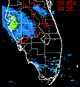
I agree with the westward drift. I'm also seeing a bulge in the NW Quadrant. Similar to an elongation in that direction.
Westward movement can be seen in the two images below.
Top image is at 0038Z and the second image is at 0341z, or about 30 minutes ago.
They are zoomed and centered on the 11 PM Center location from NHC.


| vineyardsaker |
| (Weather Guru) |
| Thu Aug 21 2008 12:10 AM |
|
|
|
|
well, except that her boss simply won't pay her if she does not show up...
Looks like Fay is moving West. God willing, she will not have the time be load up more energy before leaving the coast.
| Storm Hunter |
| (Veteran Storm Chaser) |
| Thu Aug 21 2008 12:13 AM |
|
|
|
|
Fay appears to be moving... the 50 mile wide coc is already made it pass I-95 there in Daytona Beach on the west side... hard to tell if its a true west movement of a slight north/south of west movement... one thing is for sure... thats the largest center of circulation of a tropical low i have seen in a long time! I saw a great big blow-up of convection this evening over NW of tampa.. so there appears to be some warm water off that way... will see what happens tomorrow... as for Fay, i think she's leaving the Atlantic now, SLOWLY.. but she's feeling the high to the north and now looking for the weakness to the west/north/west of her.
Help show what its like at the surface there near Daytona Beach, Fl
| Genesis |
| (Weather Guru) |
| Thu Aug 21 2008 12:19 AM |

|
|
|
It does appear, after watching this beast all night, that she's going to head west across the Peninsula this evening and be poised to emerge into the gulf sometime tomorrow evening or night.
This is not good from my point of view (NW Florida Panhandle) as if the storm goes straight west across and exits around Crystal River there's a very good chance it will have enough time to make mischief in the Gulf, and there's plenty of warm water there.
The only good news would something north of west that keeps it on land, more or less. But I don't see that in the behavior of the storm at this point in time.
Blech. I don't mind rain, even lots of it, but we do not need even a moderately strong 'Cane. A "lawn furniture rearranger", ok, but nothing stronger than that please!
The 1800Z HWRF plot is, uh, "disturbing".
http://my.sfwmd.gov/portal/page?_pageid=3194,21328260,3194_21169354:3194_21260388:3194_21260861&_dad=portal&_schema=PORTAL
|
danielw
|
| (Moderator) |
| Thu Aug 21 2008 12:20 AM |
|
|
|
|
Thanks Colleen.
Emergency Services- Fire Departments, Law Enforcement and Emergency Medical Service usually cease outside Operations at 45 mph wind speeds due to it being hazardous to the personnel.
Believe me. You don't want to be in a van type ambulance or larger, police cruiser or any Fire Apparatus in high winds. You have a tendancy to change lanes at a moments notice. And Mother Nature doesn't signal before changing lanes!!
All Danny said and fire hose streams are not effective in 50+ mph winds
| vineyardsaker |
| (Weather Guru) |
| Thu Aug 21 2008 12:25 AM |
|
|
|
|
ok. She will stay home tomorrow. thanks!
|
danielw
|
| (Moderator) |
| Thu Aug 21 2008 12:31 AM |
|
|
|
|
Southern drift too?? Or expanding circulation?
Expanding Circulation.....JK
| Colleen A. |
| (Moderator) |
| Thu Aug 21 2008 12:33 AM |
|
|
|
|
After looking at some of model plots shown on local TV, it appears that they have shifted furher south..which would be exactly why we've seen the westward movement.
As far as your wife's boss not paying her for not showing up, PM me with what she would lose in money tomorrow if she put herself in danger, and I'll write you a check if it means keeping her safe and sound at home. Nobody's life has a price tag on it.
| vineyardsaker |
| (Weather Guru) |
| Thu Aug 21 2008 12:36 AM |
|
|
|
|
we will be ok, Colleen, but thank you and God bless your kind heart. good night!
| Genesis |
| (Weather Guru) |
| Thu Aug 21 2008 12:36 AM |
|
|
|
|
Try this....
http://radar.weather.gov/ridge/radar.php?rid=MLB&product=N0R&overlay=11101111&loop=yes
Looks to me like a touch south of west; it should be obvious by morning if its going to hit the "pocket" around Crystal River. If so, that's not a good sign for people in the Panhandle and perhaps even NO (!) as it is significantly south of the current forecast track centerline.
| FloridaNative |
| (Registered User) |
| Thu Aug 21 2008 12:41 AM |
|
|
Looks to me like something is squishing this storm. Northern half looks like its being squashed as well as the COC.
|
danielw
|
| (Moderator) |
| Thu Aug 21 2008 12:42 AM |
|
|
|
|
Reading the latest Discussion on Fay. I caught this little bit of information.
THE MODEL CONSENSUS HAS SAGGED A LITTLE TO THE SOUTH...AND
SO HAS THE OFFICIAL TRACK. ALTHOUGH THE FORECAST POINTS LISTED
BELOW DO NOT EXPLICITLY INDICATE IT...THE EXACT FORECAST TRACK HUGS
THE GULF COAST OF THE FLORIDA BIG BEND AREA AT 36 TO 48 HOURS. IF
FAY ENDS UP MOVING FARTHER SOUTH THAN FORECAST...AND SPENDS MORE
TIME THAN FORECAST OVER THE NORTHEASTERN GULF...IT COULD BE AT
TROPICAL STORM STRENGTH A COUPLE OF DAYS FROM NOW.
IF...HOWEVER...IT MOVES NORTH OF THE OFFICIAL TRACK...IT COULD
WEAKEN FASTER THAN INDICATED BELOW.
REGARDLESS OF THE EXACT TRACK...FAY WILL BE MOVING RATHER SLOWLY
DURING THE NEXT SEVERAL DAYS...POSING A SIGNIFICANT HEAVY RAINFALL
AND FLOODING HAZARD TO A VERY LARGE AREA.
http://www.nhc.noaa.gov/text/refresh/MIATCDAT1+shtml/210300.shtml?text
| SirCane |
| (Storm Tracker) |
| Thu Aug 21 2008 12:43 AM |
|
|
|
|
That's not good news for the FL Panhandle/AL/MS or even possibly SE LA if it starts moving due West. I tell ya, this has been one crazy storm to track and it hasn't even reached Hurricane strength not even once. To think it could make 3 landfalls possibly in the same state is just crazy!
| Big Red Machine |
| (Storm Tracker) |
| Thu Aug 21 2008 12:51 AM |
|
|
Big blow up of a lot of red on the latest frame of the AVN (around the 345 mark). Wow.
Family and friends of mine up the road in Northern Orlando who I've spoken to in the past hour have said that currently they are getting their worst weather yet.
| StrmTrckrMiami |
| (Weather Guru) |
| Thu Aug 21 2008 01:09 AM |

|
|
|
Wierd,
Currently Fort Myers is getting an outer band of Fay??
I thought she was gone?
http://www.intellicast.com/National/Radar/Current.aspx?animate=true&location=USFL0152
| Storm Hunter |
| (Veteran Storm Chaser) |
| Thu Aug 21 2008 01:52 AM |
|
|
|
|
recon just went through at 05:38:00Z... and looks like the center fix may be near... 29.08N 80.63W with a pressure of 994-995mb... looks to me a slight north of west dirft? will see what vortex report comes in. The above location is about 15 miles from the coast. GPS dropsonde on the NE side still has winds around 50-55mph at and near the surface.
Correction... GPS dropsonde shows a 993mb reading at the surface... vortex report soon
| berrywr |
| (Weather Analyst) |
| Thu Aug 21 2008 03:46 AM |

|
|
|
There is nothing unusual about the Fay's movement. The calendar and climatology play a big role given the time of year it is right now. Faye's current location and what that synoptic pattern is gives Faye's steering component. We all watched yesterday as Faye strengthened over land but given this is Florida - GOM on one side, the Atlantic on the other, Lake Okechobee and the Everglades and a very, very favorable upper level environment conducive to strengthening if she remains over open water for any length of time and you have a recipe of a sustained tropical cyclone like Faye. We all have to remember Faye did not become a hurricane and did not have a developed inner core that is traditional with hurricanes, thus for the most part she's remained in somewhat a steady state of development with some weakening and some strengthening. The big question that lies ahead in a few days is whether the upper air ridge over the Ohio Valley and Mid-Atlantic will build enough to push Fay into the Gulf of Mexico further south than currently projected and what will be left of her if she emerges over open water.
| CDMOrlando |
| (Weather Hobbyist) |
| Thu Aug 21 2008 03:55 AM |

|
|
|
There appears to be a southwest motion to Fay. Is this a trend... time will tell.
5:38:10Z 29°05'N 80°38'W (29.08N 80.63W)
6:57:20Z 29°03'N 80°41'W (29.05N 80.68W)
Product: Air Force Vortex Message (URNT12 KNHC)
Transmitted: 21st day of the month at 06:02Z
Observation Number: 06
A. Time of Center Fix: 21st day of the month at 5:38:10Z
B. Center Fix Coordinates: 29°05'N 80°38'W (29.08N 80.63W)
B. Center Fix Location: 26 miles (42 km) to the ESE (110°) from Daytona Beach, FL, USA.
C. Minimum Height at Standard Level: 1,367m (4,485ft) at 850mb
D. Estimated (by SFMR or visually) Maximum Surface Wind: 51kts (~ 58.7mph)
E. Location of the Estimated Maximum Surface Wind: 61 nautical miles (70 statute miles) to the NNE (25°) of center fix
Product: Air Force Vortex Message (URNT12 KNHC)
Transmitted: 21st day of the month at 07:07Z
Observation Number: 11
A. Time of Center Fix: 21st day of the month at 6:57:20Z
B. Center Fix Coordinates: 29°03'N 80°41'W (29.05N 80.68W)
B. Center Fix Location: 24 miles (39 km) to the ESE (117°) from Daytona Beach, FL, USA.
D. Estimated (by SFMR or visually) Maximum Surface Wind: 45kts (~ 51.8mph)
E. Location of the Estimated Maximum Surface Wind: 36 nautical miles (41 statute miles) to the SE (127°) of center fix
| OrlandoDan |
| (Weather Master) |
| Thu Aug 21 2008 05:31 AM |
|
|
|
|
This is the worst of the weather yet in the Wekiva area of Seminole county. Winds are gusting and we are getting plenty of rain. Seminole schools are open today, ironically. NWS radara out of Melbourne has her looking a little ragged on the northern most quadrant right now, but I wonder if that is bad reflectivity. Has she made a move yet west? When?.
| kromdog |
| (Weather Hobbyist) |
| Thu Aug 21 2008 09:25 AM |
|
|
A nice day so far here in Tampa. Do you get the feeling that Fay might just be with us FOREVER!