MikeC
|
| (Admin) |
| Sat Aug 30 2008 08:06 AM |
|
|
8:30PM EDT 31 August Update
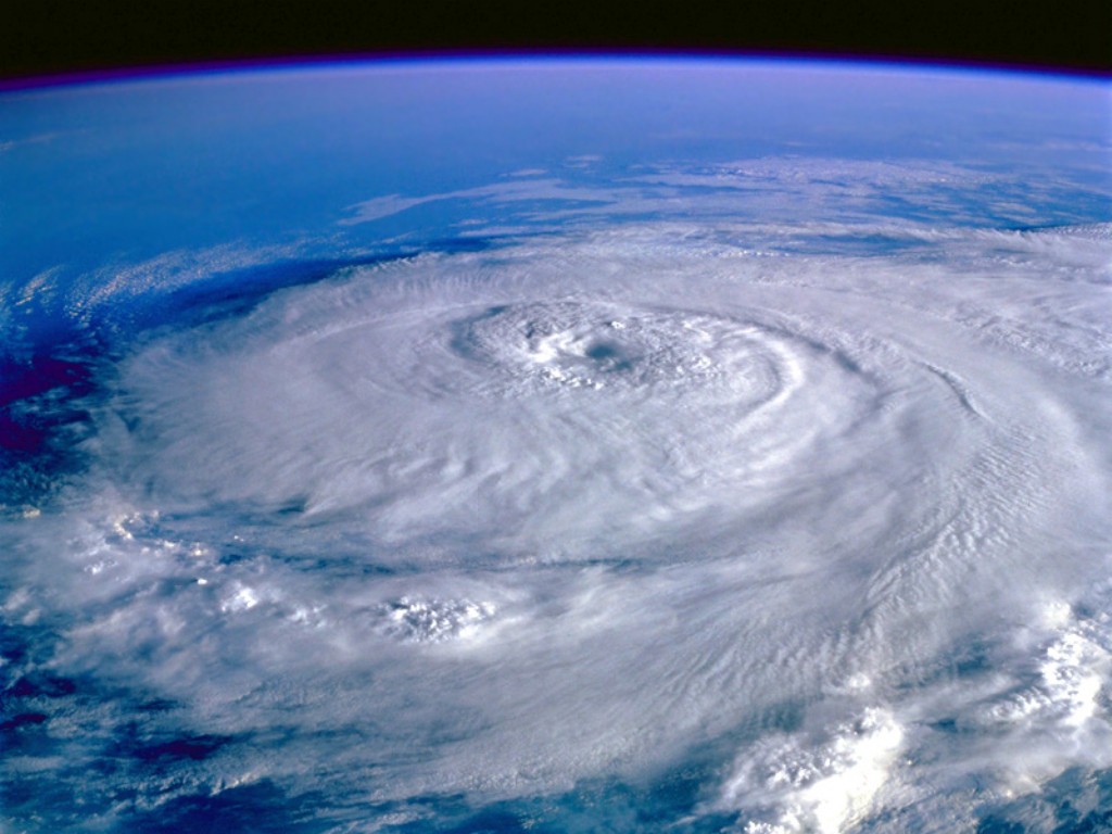
Gustav now likely to make landfall in east central Louisiana as a major Catagory III hurricane. Last visisble light satellite imagery showed a significant convective bloom over and southwest of the eye and the recon aircraft reported a central pressure of 952MB. Sustained surface winds have likely increased to at least 120mph and since the forward motion of about 15mph to the northwest has not yet decreased, Gustav should make landfall as a firm Cat III storm. Wind gusts in higher structures within the eyewall at landfall could approach 150mph. The central core of the hurricane appears to be rebuilding. The primary feeder band of the hurricane reached New Orleans at 8PM with wind gusts to 47mph at the airport. Gustav should make landfall in the mid-morning hours on Monday.
ED
8:20AM EDT 31 August Update
Gustav Weakened a bit after crossing Cuba, but remained a Major Hurricane, and has a chance to recover strength today. The storm has picked up forward motion as is Currently Moving Northwest at 16mph which would put the storm at or near landfall tomorrow night around 8 or so CDT.
If you are in Coastal Louisiana or New Orleans now YOU SHOULD NOT BE LOOKING AT THIS PAGE and should be executing evacuation plans now.

Hurricane watches remain in effect from High Island Texas to the border of Alabama and Florida, including the city of New Orleans and Lake Ponchartrain. Tropical storm watches also remain in effect from the Alabama/Florida border to Ochlochonee River. Tropical storm warnings are in effect for the western end of the Florida Keys, and tropical storm watches are in effect for the eastern keys. Mandatory evacuations have been ordered and are on-going in and around the New Orleans area. All persons in and around the watch area need to rush preparations to protect life and property, to completion.
11:15 pm Saturday Update
Hurricane Gustav now over the waters of the southeastern Gulf (23.1N/83.8W)
Hurricane watches remain in effect from High Island Texas to the border of Alabama and Florida, including the city of New Orleans and Lake Ponchartrain. Tropical storm watches also remain in effect from the Alabama/Florida border to Ochlochonee River. Tropical storm warnings are in effect for the western end of the Florida Keys, and tropical storm watches are in effect for the eastern keys. Mandatory evacuations have been ordered and are on-going in and around the New Orleans area. All persons in and around the watch area need to rush preparations to protect life and property, to completion.
Gustav took a punch in the belly for his having passed over Cuba. As of 11pm, maximum sustained winds have decreased to 140mph, and the minimum central pressure has risen to 948mb. However, with weak to no shear and rich oceanic heat content along the expect track through the east-central Gulf, the forecast for strengthening to near Category 5 status unfortunately still exists, peaking around 155mph 24 hours from now. This may be conservative. Gustav's interaction with the enormous heat potential of the Loop Current has yet to occur. Re-intensification is already underway, as recent satellite images are showing cooling cloud tops amid the CDO region, and the eye beginning to reappear. The long range radar from Key West, Florida, also shows a very sharply defined eye.
Gustav is forecast to make landfall as a very powerful hurricane, most likely near the Mississippi Delta region, between 36 and 48 hours from now; although it is important to point out that absolute certainty regarding the landfall location still can not be made.
John (typhoon_tip)
5:00 pm Saturday Update
Hurricane watch has been issued from High Island Texas to the border of Alabama and Florida, including the city of New Orleans and Lake Ponchartrain. Hurricanes conditions may develop anywhere in this watch area in 36 hours time. Preparations to secure safety and property should be well underway and completed prior to the expected arrival of very dangerous and powerful Hurricane Gustav. Evacuations in New Orleans and surrounding areas have already begun. A tropical storm watch has also been issued from Alabama/Florida border east to the Ochlockonee River.
Gustav continues to strengthen as it approaches western Cuba. As of the 5pm advisory, maximum sustained winds have increased to near 150 mph, placing Gustav a mere 5 mph shy of the Category 4/Category 5 threshold. Minimum pressure is currently 942mb.
The Tropical Prediction Center has maintained their intensity forecast, expecting the maximum sustained winds to reach as high as 140kts (160mph) during and shortly after Gustav tracks bodily across the famed Loop Current (a large eddy of particularly warm waters that also extends to greater depths than normal) in the southeastern Gulf. Currently, Gustav has responded to a weakness in the ridge over the northern Gulf and that is why were are seeing a discerned northwest motion. This is expected to continue until the point of landfall; where precisely that landfall takes place can not yet be pin-pointed, but a landfall in the northern Gulf is of higher confidence.
John (typhoon_tip)
1:30 pm Saturday Update
Gustav has continued to intensify today with peak winds now at 145 mph. Gustav is a strong category 4 hurricane on the Saffir-Simpson scale and further strengthening is possible before it makes landfall in western Cuba this evening.
Original Update
Hurricane Gustav has become a category 3 storm, with 120MPH winds as of 5PM, and recon just recently reported a pressure drop to 955mb which indicates it has grown even stronger.

The forecast track has the 3 day cone with Gustav nearing the coast Tuesday morning in an area from Northeast Texas to Alabama, with Louisiana in the middle. Most of the model guidence takes it to Central Louisiana, and it may slow down forward motion significantly as it nears the coastline or crosses over the coast making extended winds/rain likely in the landfall area.
Those in those areas should pay attention to local media and officials and official weather statements from your area. Those in areas that take a while to evacuate along the Louisiana coastline should start so now. Areas in the expanded cone should continue to watch too, especially after Gustav gets north of Cuba.
Tropical Storm Hanna's center is away from most of the convection, but it's moving generally westward, the forecast keeps it gaining strength slowly, and eventually moving southwest (which is extremely rare for hurricanes and tropical storms in this area). Avila in the 5AM discussion even mentioned Hurricane Betsy (1965) as another storm that did something similar and how today's models would react to that. That said, there appears to be even more uncertainty in the future track than with Gustav.
Also in the eastern Atlantic is a tropical wave (97L) which has the potential to develop over the next few days, and is the first likely candidate this year for a long track system (tropical depression or higher).
Graphic showing elevations of New Orleans
Emergency Management/County info
Gulf Coast Storm Alert Network
FloridaDisaster.org - Florida Emergency Management
Mississippi Emer. Management
State of Florida Division of Emergency Management/floridadisaster.org
Louisiana Emergency Management
Lousiana Evac Maps
Video/Audio Links/Webcams
NOAA Weather Radio out of New Orleans
Hurricane City - Live Audio and Video
HurricaneTrack/Mark Sudduth HIRT Team
New Orleans Webcams
French Quarter Cam
Multiple webcams located at the Port of New Orleans
Lake Ponchartrain Causeway
Metarie Webcam
Louisana Instacams
GregLeder Backyard webcam with battery backup
Maroonspoon multiple live coverage of Gustav New Orleans: WGNO, WWL, WDSU, WVUE (Mute individual ones to focus)
New Orleans Police Scanner (Req. Winamp)
Lousiana EM Radio Chatter
Louisiana DOT Traffic Cameras
Television/Radio
WWL TV 4 (CBS Affiliate in New Orleans) HERE
ABC 26 TV (ABC Affiliate in New Orleans)
WDSU Channel 6 (NBC Affiliate New Orleans)
Fox 8 (New Orleans)
WTIX 690 News Radio
WWL 870 News Radio
Hurricane Now - Video reports from former CNN hurrican reporter Jeff Flock
Weathervine.com
WKRG 5 in Mobile/Pensacola
WPMI Channel 15 from Mobile
Other
NOLA - Everything New Orleans
-- Looking for more Video/Audio links for the approach areas, please let us know if you have any links/information!
Key West Long Range Radar with hint of Gustav
Storm Surge Risks with Gustav along Louisiana
Google Map Plot of Both Gustav and Hanna
Flhurricane Long Term Recording of Cuban radar mosaic
{{StormCarib}}
{{radarlink|lix|New Orleans, LA Radar}}
{{radarlink|lch|Lake Charles, LA Radar}}
{{StormLinks|Gustav|07|7|2008|1|Gustav}}
Caribbean Islands Weather Reports
{{StormLinks|Hanna|08|8|2008|2|Hanna}}
{{StormLinks|97L|97|9|2008|3|97L}}
|
MikeC
|
| (Admin) |
| Sat Aug 30 2008 08:50 AM |
|
|
Gustav wobbled a bit to the north northwest this morning, so it's currently a little north of the 5AM forecast Track, I think wobbles like this will happen a lot, especially on a forecast track that almost looks like a straight line.
For those in the northern Gulf, this is going to be a long labor day weekend.
| MichaelA |
| (Weather Analyst) |
| Sat Aug 30 2008 09:16 AM |

|
|
|
Quote:
Gustav wobbled a bit to the north northwest this morning, so it's currently a little north of the 5AM forecast Track, I think wobbles like this will happen a lot, especially on a forecast track that almost looks like a straight line.
For those in the northern Gulf, this is going to be a long labor day weekend.
A long weekend indeed. I'm watching closely to see if that is a temporary wobble or a trend in Gustav's direction. If it becomes a trend, then all bets are off as to where eventual landfall will be.
|
danielw
|
| (Moderator) |
| Sat Aug 30 2008 09:22 AM |

|
|
|
Could Gustav be off center and wobbling??
The EYE is displaced to the right of where it should be. With respect to the high cloud tops.
However, the Eye appears to be centered against the main portion of the storm clouds.

| scottsvb |
| (Weather Master) |
| Sat Aug 30 2008 09:26 AM |
|
|
The overall pattern has been NW, there was a wobble for a hour or so NNW but overall its moving NW and will do so until Landfall. Satellite appearence looks well in 90% of Gustav with a slight SSW shear.
| scottsvb |
| (Weather Master) |
| Sat Aug 30 2008 09:32 AM |
|
|
Hanna should start really getting organzied tonight into Sunday I feel. The upper low is now a midlevel low and weakening with ridging now building in the upper levels over this. The LLC of Hanna is just SE of there and should start strengthening some this afternoon but especially tonight into Sunday. Hanna could be come a hurricane in the next 24hrs.
| smorse22 |
| (Verified CFHC User) |
| Sat Aug 30 2008 09:54 AM |
|
|
I believe that it's east of the forecasted path. Doesn't look like a wobble to me. NHC has it going around the body of land where I see it going east of it. We will see. Mentioned this earlier but my message got edited.
| Colleen A. |
| (Moderator) |
| Sat Aug 30 2008 10:13 AM |

|
|
|
Here is the WV Loop from Gustav:
WV Loop
If you click on "Forecast Points" on the top of the page, you can see that he is east of the NHC's forecasted track. Remember Fay's "wobbles"...if she hadn't made landfall when she did ... and she started making a turn faster than the NHC expected...she may have ended up making landfall as a Cat 1 further up the west coast of Florida.
The NW direction may still be the "true" direction of Gustav, but we need to pay attention to things like this..because it could affect a lot of people's weather who are not prepared for it. For the record, I've been monitoring local and national TV and they are all mentioning the "wobble".
| mcgowanmc |
| (Weather Hobbyist) |
| Sat Aug 30 2008 10:27 AM |
|
|
Quote:
Could Gustav be off center and wobbling??
The EYE is displaced to the right of where it should be. With respect to the high cloud tops.
However, the Eye appears to be centered against the main portion of the storm clouds.
I studied this as bothersome, but couldn't come up with the reason.
but try this:
Isn't the eye supposed to be where Gustav is?
If that's the case, then Gustav is, by default, to the East of the forecast track:

| Colleen A. |
| (Moderator) |
| Sat Aug 30 2008 10:40 AM |
|
|
|
|
Good graphic...it looks as though it's been to the east of the forecast track..although not by all that much...for a few hours now. However, when you look at the last frame, it appears to be moving closer to that line. We should be getting the 11am update soon...will have to wait and see what the NHC says about it.
| DMFischer |
| (Weather Hobbyist) |
| Sat Aug 30 2008 10:41 AM |
|
|
|
|
After reading about Gustav's drunken like wobble to the east, I was watching the WV loop with the forecast points up. I have learned enough from reading here that wobbles and such deviations are not unexpected. Over all the NHC projected path is close enough for me to be as prepared as possible for what is coming. Charlie also taught me that despite man's best efforts, they will sometimes just get screwed. As my kids say, stuff happens.
So I popped over to the same loop but with hanna, to see how she was doing on her anticipated curve southward. I noticed that she is well off track, or seems to be, to the north. I completely see why the curve is suppose to happen, but the delay, could this seriously alter the path of this storm?

| B_from_NC |
| (Verified CFHC User) |
| Sat Aug 30 2008 10:51 AM |
|
|
It will be interesting to see how the NHC reacts to this "wobble" as it has seemed to have persisted now for almost 4 hours. We have the long range radar out of Key West now giving us our first good look at the core.
Key West Long Range Loop
Hopefully everyone is well prepared and have made the appropriate plans.
Hurricanes are given names to distinguish themselves from others, and this will most likely be the only Gus we remember!!!
| kromdog |
| (Weather Hobbyist) |
| Sat Aug 30 2008 10:52 AM |
|
|
With a storm this size you are going to have some "wobbles" to the left and right of the official track. It looks as those Gustav is ultimately on the NHC predicted course, however everyone in the cone should pay very close attention to this powerful storm.
| Hurikid |
| (Verified CFHC User) |
| Sat Aug 30 2008 11:01 AM |
|
|
I don't know whether you guys found this, but I think recon found(earlier) flight level winds of about 146 mph in NE quad(I followed it on google earth). Does the NHC have it in them to upgrade it to a Cat 4? It's satellite presentation continues to improve and the eye is now very visible. I wish the very best to those in this deadly hurricane's path
Edit: I guess not, still cat 3 at 11 am, with winds of 125mph
| kromdog |
| (Weather Hobbyist) |
| Sat Aug 30 2008 11:04 AM |
|
|
At the 11:00 AM advisory, Gustav appears to be a little stronger with not much change in the track. Hannah however looks be on a more westerly course without that big south to southwest component. If it holds, this storm could also end up in the GOM by the end of next week.
| cmoore |
| (Registered User) |
| Sat Aug 30 2008 11:06 AM |
|
|
Not to sound like a complete idiot, but can someone please tell me what is keeping Gustav moving NW, vs further N? (in other words having more affect on the Gulf Coast of MISS, Al and Fl) Everything is showing it towards TX - LA border and I would like to breathe a sigh of relief .....(I know I know, I am watching it) but I'm wondering what it is that keeping it on that path, weather wise.....
| Colleen A. |
| (Moderator) |
| Sat Aug 30 2008 11:10 AM |
|
|
|
|
Well, apparantly the NHC has seen the same thing we saw with the wobbles:
THE NEW
OFFICIAL FORECAST TRACK REMAINS CONSISTENT WITH THE REMAINING
GUIDANCE IN TAKING GUSTAV INLAND IN LESS THAN 72 HOURS...AND IS
JUST EDGED EVER SO SLIGHTLY TO THE RIGHT...IN PART TO ACCOUNT FOR
THE RECENT RIGHT OF TRACK MOTION. REGARDLESS OF THE DETAILS IN THE
TRACK...GUSTAV WILL LIKELY SLOW DOWN SIGNIFICANTLY IN THE
LONGER-TERM...WHICH COULD CAUSE A CONSIDERABLE FLOODING THREAT OVER
LOUISIANA AND TEXAS.
You can read the entire discussion by clicking on "Current Storms" on the left-hand side of the main page then clicking on "Government Discussion".
| Colleen A. |
| (Moderator) |
| Sat Aug 30 2008 11:15 AM |
|
|
|
|
I am not a met, so take this as you will: those winds of 146mph were found at flight level where recon is flying, not at the surface level. That is why they did not upgrade it to a Cat 4. The NHC would never hold back on upgrading a hurricane to a Cat 4.
Hope that answers your question.

| CDMOrlando |
| (Weather Hobbyist) |
| Sat Aug 30 2008 11:45 AM |

|
|
|
PRELIMINARY EXTENDED FORECAST DISCUSSION
NWS HYDROMETEOROLOGICAL PREDICTION CENTER CAMP SPRINGS MD
926 AM EDT SAT AUG 30 2008
...TWO TROPICAL SYSTEMS IMPACTING U.S. WEATHER THIS PERIOD...
ALL MODELS DEVELOP STRONG MID LEVEL RIDGING OVER ERN CONUS TUES AND WED WITH ITS AXIS SHIFTING EWD
OVER THE MID ATLC STATES REGION AND ADJACENT ATLC. WHILE THE OVERALL PATTERN IS SIMILAR THERE ARE ENOUGH DETAIL DIFFERENCES TO IMPACT THE TRACKS OF TROPICAL SYSTEMS GUSTAV AND HANNA MAINLY MID AND LATE PERIOD.
GLOBAL DYNAMICAL MODELS HAVE BEEN MUCH MORE CONSISTENT AND IN FAIRLY GOOD AGREEMENT ON ITS SW TRACK INTO THE BAHAMAS BY DAY 5. ITS FUTURE DEPENDS MUCH UPON HOW MUCH RIDGING BUILDS IN NORTH OF THE SYSTEM ACROSS THE MID ATLC STATES AND ADJACENT ATLC AS THE RIDGING REPLACES AN EXITING MID LEVEL LOW OFF THE MARITIMES.
CMC/GFS AND ECMWF AND ITS ENS MEAN HOLD ONTO THE RIDGE AND MOVE HANNA AROUND ITS WEST PERIPHERY. BIGGEST QUESTION IS WHERE WILL HANNA BE AS THE MID LEVEL EVOLVES. 00Z/06Z GFS/NOGAPS AND GFS ENS MEAN GAIN THE HIGHEST LATITUDE IN THE BAHAMAS WITH HANNA ALLOWING FOR A FUTURE DAYS 6 AND 7 TRACK MUCH MORE EWD TAKING HANNA INTO
THE SOUTHEAST COAST DAYS 6/7 AS DOES DGEX. CMC AND ECMWF START OUT FROM DAY 5 AT LOWER LATITUDES AND MAKE THE NW AND N TURN ALONG THE WEST COAST OF FL OR ERN GLFMEX. UKMET GOES THE FARTHEST SOUTH WITH THIS SYSTEM ON THE SOUTH SIDE OF CUBA BY DAY 5. PREVIOUS YEARS THE UKMET WAS ONE OF THE BETTER MODELS IN THE CARRIBEAN AND WRN ATLC
IF ONE ADJUSTED ITS LATITUDE SEVERAL DEGREES NWD. MAKING THIS ADJUSTMENT WOULD PUT IT INTO THE ECMWF/CMC CAMP. BEGINNING FROM THE TPC DAY 5 POSITION WHICH IS IN THE MIDDLE OF THE GROUPING..
HPC PREFERENCE WOULD BE AN ECMWF ENS MEAN AND PROGS HAVE BEEN ADJUSTED FOR THIS FOR DAYS 6 AND 7 FRI/SAT. THIS IS WITHIN THE SPREAD ENVELOPE ON THE WEST SIDE TAKING HANNA FROM THE FL STRAITS FRI ALONG THE WEST FL COAST TO NEAR APALACHEE BAY SAT. THIS SOLUTION IS ALSO SLOWER THAN ALL OP MODELS BUT IN LATITUDINAL AGREEMENT OF BOTH GFS AND ECMWF ENS MEANS.
SEE TPC FORCASTS/ADVISORIES/DISCUSSION OF HANNA.
The HPC has the hard task of giving 7 day forcasts. They were the first to predict the Fay stall. They are only concerned with the general area that will be impacted (like Florida or southeast) not the precise location of landfall. But, over the years have found their information usefull for longer range planning.
| scottsvb |
| (Weather Master) |
| Sat Aug 30 2008 11:53 AM |
|
|
I've gotten PM'S on my thoughts on Gustav's future path. Please go to Gustav lounge on page 2 and top of page 4. My idea on Hanna is up in the air still, a few things can happen still while Gustav is pretty straight-forward still, nothing has changed in 5 days.
| scottsvb |
| (Weather Master) |
| Sat Aug 30 2008 12:01 PM |
|
|
CDMOrlando that is close to my thinking also, but I won't have a good grasp on this yet until the pattern sets up better. Probably Monday I'll have my thoughts on Hanna.
|
danielw
|
| (Moderator) |
| Sat Aug 30 2008 12:26 PM |
|
|
|
|
Key West 248nm radar has a great 'live' pic of Gustav.

| Storm Hunter |
| (Veteran Storm Chaser) |
| Sat Aug 30 2008 12:31 PM |

|
|
|
Very nice 248nm scan on Key west radar.. but even better close-up of the eye here. thought i may have seen two small vortices inside the eye... hard to tell, wish they turn rapid scan to the storm...
Smile... its an eye!
| Steve H1 |
| (Storm Tracker) |
| Sat Aug 30 2008 12:33 PM |
|
|
Now Hanna is beginning to make me a little nervous. Some of that is a result of the 12Z GFS which keeps her east of the Florida coastline making land fall in SC. This would normally make me breathe a sigh of relief, but the more reliable guidance seems to have her going over or up the west coast of the Florida peninsula. Chances are the answer lies somewhere in between. GFS intensifies her quite a bit as well, since normally at this resolution it doesn't show cyclones that deep (ex. Gustav). We still have a few days to get a feeling on where she is headed, but I am going to make sure I have my supplies ready, know where they are, and make sure I have enough cash and propane. Now is the time to get prepared. This afternoon's ECM will be interesting. Cheers!
| TheElNino1 |
| (Registered User) |
| Sat Aug 30 2008 12:46 PM |
| Attachment |
|
|
From the latest IR image it looks like Gustav is going through an eyewall replacement cycle at this time. The image shows the ragged inner eye surrounded by an outer eyewall. It's likely Gustav will not strengthen until the cycle is complete. I remember Katrina expanding it's windfield when this happened prior to becoming a Cat 5 hurricane over the warm Gulf loop.
My mistake, an ERC is not happening with Gustav at this time, though, it definitely has a double eyewall.
| allan |
| (Weather Master) |
| Sat Aug 30 2008 01:01 PM |
| Attachment |

|
|
|
I am starting to believe that Hanna is going to be a headache for me, the path is starting to become a bit clearer but still hard to track. Gustav is most likely a category 4 storm now with winds of probably 130-140 mph. It's northward movement is putting the Cayman Islands in the eye. I know Gustav will lose a bit of power while crossing Cuba, but I'm really inclined to believe Fox News and it's something that I have been predicting for a few days that Gustav will possibly reach category 5 intensity right after crossing Cuba, then it should start to slowly weaken due to northwesterly shear. I have made my runs last night on both Hanna and Gustav and still sticking to the tracks yet Gustav is a category 3 storm, not a 1 as it says on the attachment. So far it's holding good, but anything can change. Hanna on the other hand, I might have to nudge my track eastward on the 2nd run if the models begin the "eastward" trend. Something tells me I need to go to the store this week to buy some stuff. Please click attachments for my run on Gustav.
| cieldumort |
| (Moderator) |
| Sat Aug 30 2008 01:04 PM |

|
|
|
Recon looks to be about to send out a new Vort with pressure down to around 944mb with flight level winds at 138 knots.
Gustav is likely now a very dangerous and still-intensifying Category 4 hurricane on the Saffir-Simpson Scale. Hurricane force winds extend well-away from the eye. Western Cuba will take a bite out of the cyclone, but given its forward rate of speed and the relative flatness of the western half of Cuba, it won't be much of a bite.
| Storm Hunter |
| (Veteran Storm Chaser) |
| Sat Aug 30 2008 01:09 PM |
|
|
|
|
agree.. dropsonde shows 945mb (27.91 inHg) at the surface... with a wind of 4kts at the surface... in the dead center it looks like at or around 21.4N 82.4W and an air temp of 28.0°C (82.4°F) at the surface with a dew point of 27.0°C (80.6°F)
second dropsonde released in the SW side of the eye (dropped in the eyewall) has a 116 knots (133 mph) surface wind and a pressure of 935mb (27.61 inHg)... kind suspect to me... around 21.3N 82.5W.
| Steve H1 |
| (Storm Tracker) |
| Sat Aug 30 2008 01:11 PM |
|
|
I don't believe that western Cuba will take much of a bite out of him, as I understand this region is fairly flat (understandably). I think he should approach cat 5 before weakening prior to landfall as it hits some of the warm eddies in the GOM. Some encouraging news on the Hanna front, the Canadien has shifted east on the 12z run, which was further west on the 0z. Hopefully the ECM will follow suit. But we will probably see them go back and forth over the next few days.
| allan |
| (Weather Master) |
| Sat Aug 30 2008 01:18 PM |
|
|
|
|
Time:
16:49:00Z
Coordinates:
21.65N 82.1W
Flt. Lvl. Wind (30s):
From 138° at 132 knots (From the SE at ~ 151.8 mph)
Peak (10s) Flt. Lvl. Wind:
137 knots (~ 157.5 mph)
Recon reports near the center or at the center... This is getting serious. With Katrina, NO got lucky if you really think about it. Katrina s left (weaker) side of the storm hit the city. Gustav is expected to bring the right (stronger) side to the city which might mean the storm surge "could" be worse then Katrina. Something to think about, my heart and prayer goes out to the people in the path of this extremely dangerous cyclone.
A year after Rita hit in 2005, I toured and helped out with cleaning the damage and fixing homes, it was my church's mission trip. It was completely devastated, the beach was gone. The really dangerous thing about Gustav is that both Rita and Katrina areas will be impacted severely.
| Colleen A. |
| (Moderator) |
| Sat Aug 30 2008 01:20 PM |
|
|
|
|
It looks to me as if Isle of Youth is going to take a little bit less of a hit than thought before. The center of Gustav keeps jumping back and forth..looks like they are about to get the west side of Gustav on the eastern side of the island. I know the jumps are common, but the difference for them is a big one..a direct hit vs. a brush. Still devastating, though.

sorry...had my islands mixed up!
 Thanks for pointing that out!
| Lamar-Plant City |
| (Storm Tracker) |
| Sat Aug 30 2008 01:22 PM |

|
|
|
Just keep this in mind (and we are already seeing it a LOT this seaso)....the models do NOT do even a fair job on weak TS. Fay was a mess and Hanna is following suit, whereas Gustav as a stronger storm over the past 4 days has not REALLY given the models much problem. Yes, the cone is wide at the end of Gustav's travels, but part of that may be attributed to it being weaker at that point after making landfall. Models have really been unusually consistent on Gustav. Until Hanna gets stronger, I am really not paying attention to the models on her at all as they are just slightly more than worthless.....
| Rich B |
| (British Meteorologist) |
| Sat Aug 30 2008 01:23 PM |
|
|
Gustav now upto Cat 4 with 145 mph winds... and still he gets stronger...
| Tazmanian93 |
| (Weather Master) |
| Sat Aug 30 2008 01:36 PM |

|
|
|
Afternoon all... WOW, incredible rapid deepening. Is it my eyes, or (and I know common) but is Gus moving more N of NW than NW? I was just in NOLA in the winter for business and it was incredible to see the rebuilding that had taken place and now for this to happen. Prayers are out and constant !
http://my.sfwmd.gov/sfwmd/common/images/weather/noaaport/radar_byx2_anim.gif
| pcola |
| (Storm Tracker) |
| Sat Aug 30 2008 01:41 PM |

|
|
|
Quote:
It looks to me as if Grand Cayman Island is going to take a little bit less of a hit than thought before. The center of Gustav keeps jumping back and forth..looks like they are about to get the west side of Gustav on the eastern side of the island. I know the jumps are common, but the difference for them is a big one..a direct hit vs. a brush. Still devastating, though.
Sorry for the one liner, but that is not Grand Caymen..Gustav is past bthat...the island Gustav is approaching is the Isle of Youth, part of Cuba
| cieldumort |
| (Moderator) |
| Sat Aug 30 2008 01:42 PM |
|
|
|
|
Quote:
From the latest IR image it looks like Gustav is going through an eyewall replacement cycle at this time. The image shows the ragged inner eye surrounded by an outer eyewall. It's likely Gustav will not strengthen until the cycle is complete. I remember Katrina expanding it's windfield when this happened prior to becoming a Cat 5 hurricane over the warm Gulf loop.
It's often fool's bait to rely on IR images to determine whether or not an ERC is underway.
Stick to the data from recon, and available radar. These do not show any imminent ERC.
| Steve H1 |
| (Storm Tracker) |
| Sat Aug 30 2008 01:50 PM |
|
|
Point taken Lamar, she is still a somewhat naked circulation and a lot can change. I agree not a straightforward track at all like Gustav's.
| smorse22 |
| (Verified CFHC User) |
| Sat Aug 30 2008 01:54 PM |
|
|
Quote:
Afternoon all... WOW, incredible rapid deepening. Is it my eyes, or (and I know common) but is Gus moving more N of NW than NW? I was just in NOLA in the winter for business and it was incredible to see the rebuilding that had taken place and now for this to happen. Prayers are out and constant !
http://my.sfwmd.gov/sfwmd/common/images/weather/noaaport/radar_byx2_anim.gif
I agree. I believe that it's moving more N of NW. Continues to be east of NHC projected path.
| RedingtonBeachGuy |
| (Moderator) |
| Sat Aug 30 2008 02:37 PM |
|
|
It appears to my layman view the previous two day track is dead center on the NHC prediction. I wouldn't put any stock on a few hours of wobbles myself.
| Colleen A. |
| (Moderator) |
| Sat Aug 30 2008 02:45 PM |
|
|
|
|
Although I agree that we have to see more of a few hours of wobbling before looking for a track change; however, it is important to note that the 5am track had Gus going straight over the Isle of Youth, at 11am they shifted the track back bythismuch to the right because of those wobbles - which has a direct impact on those who are in it's path.
It may not be as important when it's over water, but when it's as close to land as it is right now, it's really important.
| Bloodstar |
| (Moderator) |
| Sat Aug 30 2008 02:47 PM |

|
|
|
have to say I think it has trended about 10 degrees right of the track, which isn't a big difference, however when you're dealing with a major storm, it changed dramatically who's going to be impacted. (again people shouldn't just look at the line, look at the entire cone and keep prepared!)
That being said, the lated HH has the pressure down to around 939mb as of 2:35. so the storm is still Intensifying Rapidly. It's getting close to Cuba, so the intensification has to stop soon, but it still has another few hours before the land interaction will disrupt the storm. I just hope Cuba's ready for this one. I don't know if people expected it to be quite this strong as it headed north.
The next 3 days, I think the NHC has a good handle on things, and being slightly off is to be expected (5 day errors of 300 miles is average, remember). Anyone from Houston to Mobile has to keep an eye on this thing. and if I were in the Florida panhandle and on the Texas coast south of Houston, I'd still be watching closely in case something unexpected does happen.
Good luck to everyone in the path.
| Random Chaos |
| (Weather Analyst) |
| Sat Aug 30 2008 04:21 PM |

|
|
|
Just want to point out MODIS's Terra satellite took a spectacular picture of Gustov a couple hours ago:
http://rapidfire.sci.gsfc.nasa.gov/realt...3160501.1km.jpg
Be sure to zoom in using the alternate sizes on the left.
| Storm Hunter |
| (Veteran Storm Chaser) |
| Sat Aug 30 2008 04:55 PM |
|
|
|
|
5pm winds up 150mph... pressure to 942mb and new hurricane watch up for the gulf coast... and tropical storm watch up...
eye is getting smaller... want be long til first ERC to take affect.. most likely over land of Cuba
(I had already updated the main page with the NHC information and Gustav statistics for the 5pm advisory so there is no need to do so here... Thanks!
John)
| smorse22 |
| (Verified CFHC User) |
| Sat Aug 30 2008 05:08 PM |
|
|
Does Gustav look like it went alittle north after it passed the little body of land (not sure what it is)? I understand that it's probably a wobble but it has slowly been moving to the right throughout the day. But the NHC track seems not to change. Just wanted to get your thoughts. After looking at the second link. I believe it did move north.
http://www.ssd.noaa.gov/goes/flt/t1/loop-vis.html
| typhoon_tip |
| (Meteorologist) |
| Sat Aug 30 2008 05:22 PM |
|
|
And now as of 5pm...150mph hour!
It will interesting to see what affects Cuba has on this... The elevations of Cuba are not nearly as tall as Hisp. They do not disrupt the boundary layer flow as they only extend to around 1,500' on the western end of the island. This should impede some on the circulation, but I believe fully that a very dangerous and powerful hurricane will emerge on the northern coast of Cuba. After that, wow - this goes bodily across the Loop Current with almost no shear in the deep layer.
| native |
| (Weather Guru) |
| Sat Aug 30 2008 05:43 PM |

|
|
|
That would be the Isle of Youth you're referring to.
What is keeping NHC on their path prediction(s) is the model guidance. If you click on the picture of the 5 day map of Gustav to the left here and scroll down to view Skeetobite's map, you'll clearly see what the NHC is seeing and hence the reasoning behind their estimates.
You'll note that all the models are in excellent agreement...until Gustav moves inland, it is only then that you'll see some deviation between them.
| Lamar-Plant City |
| (Storm Tracker) |
| Sat Aug 30 2008 05:46 PM |
|
|
|
|
Quote:
Does Gustav look like it went alittle north after it passed the little body of land (not sure what it is)? I understand that it's probably a wobble but it has slowly been moving to the right throughout the day. But the NHC track seems not to change. Just wanted to get your thoughts. After looking at the second link. I believe it did move north.
First, that 'little body of land' is known as the Isle of Youth. It was known as the Isle of Pines until about 1978. Population of about 100,000. And yes, it sure looks to me like the eye has wobbled more north than west since about 10am this morning. Hope it is a wobble and any trend in that direction puts the effects of this thing much closer to the Fl west coast. We are already seeing enhanced storms and showers today in what seems like early spiral patterns across the state. Pretty active too. Keeping my fingers crossed and prayers going out for all in the path!
| vineyardsaker |
| (Weather Guru) |
| Sat Aug 30 2008 05:52 PM |
|
|
|
|
The Latest NHC track has Hanna moving in a more WNW direction. Not only this, but all the models except the UKMET have Hanna heading either for northern Florida or even Georgia. (What happened to the prediction that it was headed to Miami or even Cuba?!). So far, no models are predicting a hurricane, but how much confidence would you place in these models?
Is Hanna likely to become a real threat to Florida?
Thanks,
VS
| jf |
| (Verified CFHC User) |
| Sat Aug 30 2008 05:55 PM |
|
|
The last few radar and sat clips indicate that at least for the last 1 1/2 hours that Gustav has moved on a more northerly track as it approaches the southern coast of Cuba. If after passing over Cuba and into the Gulf this trend continues then I am sure that models as well as the NHC will take note. The storm has been tracking east of the projected targets all day long but this past 1 1/2 hours was a more pronounced northerly shift ? or wobble.
| native |
| (Weather Guru) |
| Sat Aug 30 2008 06:02 PM |
|
|
|
|
I personally, wouldn't put too much stock in those models right now. Until the ULL fully pulls off and the high sets in, the models are going to change on just about every run. Just read the 5pm Disco...NHC has very low confidence in them at the present time.
It's hurricane season as you know, and as a Floridian, I would hope you already have hurricane supplies and a solid plan in place and ready for a potential storm regardless of Hanna or not.
If it comes, it comes...nothing you can do about that. All you can do is be prepared and stay informed. Just don't watch too much TWC or you'll just drive yourself bonkers!!

| Ronn |
| (User) |
| Sat Aug 30 2008 06:10 PM |

|
|
|
jf,
Gustav has wobbled slightly to the NNW over the past couple of hours, but this is almost certainly just a wobble. With Gustav's clearly defined eye, we are able to see very slight wobbles that usually go unnoticed when tracking more poorly defined systems.
| Beach |
| (Weather Guru) |
| Sat Aug 30 2008 06:10 PM |

|
|
|
http://www.ssd.noaa.gov/goes/east/gmex/loop-vis.html
It kind of looks that way at the moment.
I was looking at the bouy info in the Keys and things are starting to get blustry.
Sand Key Fl:
Wind Direction (WDIR): E ( 80 deg true )
Wind Speed (WSPD): 34 kts
Wind Gust (GST): 37 kts
Atmospheric Pressure (PRES): 29.70 in
Pressure Tendency (PTDY): -0.09 in ( Falling Rapidly )
Air Temperature (ATMP): 80.6 °F
Polaska Shoal Light:
Wind Direction (WDIR): E ( 80 deg true )
Wind Speed (WSPD): 28 kts
Wind Gust (GST): 32 kts
Atmospheric Pressure (PRES): 29.68 in
Pressure Tendency (PTDY): -0.09 in ( Falling )
Air Temperature (ATMP): 79.3 °F
Water Temperature (WTMP): 86.2 °F
Sombraro Key:
Wind Direction (WDIR): ENE ( 70 deg true )
Wind Speed (WSPD): 24 kts
Wind Gust (GST): 26 kts
Atmospheric Pressure (PRES): 29.73 in
Pressure Tendency (PTDY): -0.04 in ( Falling )
Air Temperature (ATMP): 80.2 °F
Salinity (SAL): 30.48 psu
Dew Point (DEWP): 73.9 °F
Tide (above MLLW) (TIDE): 0.97 ft
Heat Index (HEAT): 84.9 °F
| jf |
| (Verified CFHC User) |
| Sat Aug 30 2008 06:26 PM |
|
|
Gustav has come ashore at the narrowest point in Cuba and likely will not be affected by the land mass, other than a temporary abatement of its growth. Once over the warm waters of the Gulf it's anything goes.
It seems as though when the satelites are taking photos of the various storms , if they are not directly over the storm , the results of the photos are somewhat misleading.
| watchinout |
| (Verified CFHC User) |
| Sat Aug 30 2008 06:36 PM |
|
|
I'm not an expert but i've seen on here in the past if a storms outer bans are being pulled in a certain direction then that's the direction the storm is traveling in. Does'nt it look like these outer bans are being pulled more to the due north. Also can someone tell me why if Gus is'nt suppose to come toward Florida because of the ridge over us then how come the outer bans are'nt being affected by this ridge.
| berrywr |
| (Weather Analyst) |
| Sat Aug 30 2008 06:40 PM |

|
|
|
I looked at this same trend early this morning and noted during the past 24 hours it is NNW and currently on a direct line to the Bootheville, LA; the mouth of the Mississippi River. My biggest concern for New Orleans is Gustav's forward speed and when the upper ridge is likely to be in place over the NE US and able to steer Gustav more westward of it's current vector. Any slight deviation to the right and this is the worse case scenario for New Orleans given the topography and the amount of water Gustav is likely to pile up in that area. My prayers are with Abbeville and all the South Central LA coast; and hope this time everybody gets out of the way. I live in the Auburn-Opelika, Alabama and we received 6 inches of rain from Fay; we don't need any gale force winds, or any part of Fay's track last week getting any high winds, but that pales to our neighbors to our SW. To those of you down there, we will be thinking of you for the foreseeable future; Godspeed to all of you.
| Ronn |
| (User) |
| Sat Aug 30 2008 06:48 PM |
|
|
|
|
watchinout,
Gustav has enhanced Florida's usual afternoon and evening thunderstorm activity. On satellite imagery, this is resulting in the exaggerated appearance of Gustav's cloud structure being elongated south to north. In some cases, this can indicate the future direction a storm will take. This is not true in Gustav's case. The enhancement of convective activity over the Florida peninsula is painting a somewhat misleading picture.
| Colleen A. |
| (Moderator) |
| Sat Aug 30 2008 07:24 PM |
|
|
|
|
It does appear that even with the wobbles Gustav had today, he is now clearly on a NW path...at quite a good clip, too. But we must also keep this in mind: this storm is HUGE...and will impact a lot of people, not just NOLA.
| WeatherNut |
| (Weather Master) |
| Sat Aug 30 2008 08:07 PM |
|
|
I noticed on the last vortex msg that the Temp outside the eye was 10c and inside the eye was 22c. The dewpoint outside the eye was 6c. Thats a HUGE amount of energy coming out of this storm. I dont think Katrina had that kind of temp difference.
EDIT...I looked in the archives and when Katrina had a pressure of 908mb the temp inside the eye was 25c and outside was 13c and the outside dewpoint was 17c. Perhaps one of the mets can explain this (cause I'm not even that sure of how significant it is)
| vineyardsaker |
| (Weather Guru) |
| Sat Aug 30 2008 08:12 PM |
|
|
|
|
This from the NHC advisory for the US landfall
A POTENTIAL STORM SURGE OF 15 TO 20 FEET WILL BE POSSIBLE NEAR AND
TO THE RIGHT OF LOCATION OF LANDFALL OF HURRICANE GUSTAV .
and this for the advisory for Cuba: COASTAL STORM SURGE FLOODING OF 18 TO 23 FEET ABOVE NORMAL TIDE
LEVELS...ALONG WITH LARGE AND DANGEROUS BATTERING WAVES
If New Orleans gets hit by a 20+ foot storm surge and Cat4 winds at the same time I cannot image the city surviving this. I just hope and pray that this will hapeen at low tide. Does anybody know?
| MichaelA |
| (Weather Analyst) |
| Sat Aug 30 2008 08:47 PM |
|
|
|
|
Fortunately, NOLA is not exactly located right on the coast. There is plenty of lowland and swamp south of the city that helps to absorb storm surges. However, much of the city is below sea level, so an extended period of heavy rain coupled with a storm surge will put extraordinary stress on the city's flood control devices. You can't pump water out if there's nowhere to pump it to.
|
danielw
|
| (Moderator) |
| Sat Aug 30 2008 08:58 PM |
|
|
|
|
For a bit more information on a Hurricane with a track similar to Gustav's track.
Google Hurricane Betsy-1965 or Hurricane Pam, which was an exercise run against a hypothetical Hurricane called Pam.
Both Betsy and Pam had a SE to NW track near New Orleans.
Betsy left New Orleans in a huge mess. That's why the Levee System was built. At least one of the reasons.
| MichaelA |
| (Weather Analyst) |
| Sat Aug 30 2008 09:22 PM |
|
|
|
|
Long range Key West NWS radar shows the eye moving off the North coast of Cuba now. Looks intact.
| Beach |
| (Weather Guru) |
| Sat Aug 30 2008 09:26 PM |
|
|
|
|
Have you benn watching the winds in the keys.
Sand Keys:
Wind Direction (WDIR): E ( 100 deg true )
Wind Speed (WSPD): 47 kts
Wind Gust (GST): 50 kts
Atmospheric Pressure (PRES): 29.70 in
Pressure Tendency (PTDY): +0.00 in ( Steady )
Air Temperature (ATMP): 80.2 °F
Polaski Shoal:
Wind Direction (WDIR): E ( 80 deg true )
Wind Speed (WSPD): 40 kts
Wind Gust (GST): 47 kts
Atmospheric Pressure (PRES): 29.61 in
Pressure Tendency (PTDY): -0.05 in ( Falling )
Air Temperature (ATMP): 83.1 °F
Water Temperature (WTMP): 86.0 °F
Sombraro Key:
Wind Direction (WDIR): ESE ( 110 deg true )
Wind Speed (WSPD): 41 kts
Wind Gust (GST): 43 kts
Atmospheric Pressure (PRES): 29.72 in
Pressure Tendency (PTDY): +0.00 in ( Steady )
Air Temperature (ATMP): 79.9 °F
Salinity (SAL): 30.18 psu
Dew Point (DEWP): 76.8 °F
Tide (above MLLW) (TIDE): 2.47 ft
Heat Index (HEAT): 85.5 °F
Key West Radar:
http://radar.weather.gov/ridge/radar_lite.php?rid=amx&product=N0R&loop=yes
Latest from Habana Cuba:
Latest 9 PM (1) Aug 30 77 (25) 73 (23) 29.44 (0997) SE 31 heavy rain
Wind Direction (WDIR): E ( 100 deg true )
Wind Speed (WSPD): 47 kts
Wind Gust (GST): 50 kts
Atmospheric Pressure (PRES): 29.70 in
Pressure Tendency (PTDY): +0.00 in ( Steady )
Air Temperature (ATMP): 80.2 °F
| mcgowanmc |
| (Weather Hobbyist) |
| Sat Aug 30 2008 09:30 PM |
|
|
Quote:
For a bit more information on a Hurricane with a track similar to Gustav's track.
Google Hurricane Betsy-1965 or Hurricane Pam, which was an exercise run against a hypothetical Hurricane called Pam.
Both Betsy and Pam had a SE to NW track near New Orleans.
Betsy left New Orleans in a huge mess. That's why the Levee System was built. At least one of the reasons.
I study the hydrology of MS River and it's tributaries up to Memphis. I'm familiar with the oil/gas structure
of the area as well as Chemical Alley stretching 30 miles to the West.
If CAT 4 Gustav dumps 26" North of Houma as it surges into Lake Pontchartrain, fill up your tanks.
Gas will be $5 by the next week.
| madmumbler |
| (Storm Tracker) |
| Sat Aug 30 2008 09:32 PM |

|
|
|
Quote:
It does appear that even with the wobbles Gustav had today, he is now clearly on a NW path...at quite a good clip, too. But we must also keep this in mind: this storm is HUGE...and will impact a lot of people, not just NOLA.
We've already got some pretty intense rain bands today here in w. Charlotte County (Fl). On top of all the water from TS Fay, there's going to be some inland flooding, most likely. Everyone needs to remember the impact isn't just wind and storm surge, it's rainfall. This system will dump a ton of water on an already saturated area, which will only compound the problems.
| Seminolestormwatcher |
| (Registered User) |
| Sat Aug 30 2008 10:22 PM |
|
|
|
I sure hope the 11:00 pm advisory dosent move the cone any closer to florida. Gus sure does seem to have wobbled some to the north. Does anyone else think it is possible for this huge storm to have an effect on west-central Florida?
| FIREREALTY |
| (Registered User) |
| Sat Aug 30 2008 10:32 PM |
|
|
Well, if it does wobble to the east, and becomes a Fla. issue, there won't be much time to react with that big of a storm. I'm betting if they even had an outside chance that was to happen they'd have alrady metioned it. I've not seen anyhting at all on that even being a remote possibility. The closest I ever saw was one model putting it into Tallahassee area. I think we in Fla. will skate on this one with nothing but more rains-so much for the drought!! Hanna will be more rains too...so Lake Okeechobee will be back to regular height, its close now. And they said it'll be
 years before we get enough rain to refill that thing......
| StrmTrckrMiami |
| (Weather Guru) |
| Sat Aug 30 2008 10:32 PM |

|
|
|
Quote:
I sure hope the 11:00 pm advisory dosent move the cone any closer to florida. Gus sure does seem to have wobbled some to the north. Does anyone else think it is possible for this huge storm to have an effect on west-central Florida?
I would like to know the same thing.
If anything, I'm prepared for the power to go out..and so just in case the storm wobbles toward us, I'm Getting out!! I'm scared of Cat 5 hurricanes. Especially after Katrina..
| Thunderbird12 |
| (Meteorologist) |
| Sat Aug 30 2008 11:05 PM |
|
|
The latest NHC forecast track looks about the same as before, though the most recent model guidance has nudged a little to the east, with many of the models indicating very little deviation from the current bearing before landfall. That would be bad news, but whether or not that is a trend remains to be seen. At this point, small changes in the bearing of the storm will make a big difference on the number of people potentially in the direct path of the storm. Stay tuned, as if anyone needs to be reminded of that.
Intensity-wise, it is hard to say what will happen, though the odds favor additional intensification at least over the southern Gulf. Outflow has been somewhat restricted on the southern side of the storm, but that seems to have improved during the day. Once it gets closer to the Gulf Coast, past history strongly suggests it will come down at least a little from peak intensity, but there is a good chance of a major hurricane at landfall.
| Ronn |
| (User) |
| Sat Aug 30 2008 11:11 PM |
|
|
|
|
West-central Florida will experience rain bands and breezy conditions on Sunday and Monday, thanks to being on the eastern side of a large hurricane . A track slightly to the east of the current forecast track would elevate the rain and wind a little more than expected across the region; however, West-central Florida will likely escape any major impact from the storm. The rain bands should move quickly enough so that significant flooding is not a concern. Gustav is moving fast and everything points to landfall on the north-central Gulf coast. The consistency in the models has been remarkable.
| vineyardsaker |
| (Weather Guru) |
| Sat Aug 30 2008 11:48 PM |
|
|
|
|
I just listened to the press conference of Mayor Nagin. He speaks of the "mother of all storms", the "storm of the century" and of a storm whose power the NHC cannot imagine. He ordered a complete evacuation of NO.
|
danielw
|
| (Moderator) |
| Sun Aug 31 2008 12:06 AM |
|
|
|
|
They learned a lot 3 years ago. And he's trying hard not to make the same mistakes.
It appears that the New Governor, Bobby Jindal is on top of things too.
As soon as NHC came out with a faster forward speed. Jindal moved up the time for ContraFlow to go into effect. It was 6 AM CDT, it now begins at 4 AM CDT and runs until at least Midnight Sunday Night.
HURRICANE WARNINGS WILL LIKELY BE REQUIRED FOR PORTIONS FOR THE
NORTHERN GULF COAST ON THE NEXT ADVISORY.
Gustav appears to be in an Eyewall Replacement Cycle- ERC. As the Eye has disappeared from IR satellite imagery. If this is actually occuring Gustav would beginn to shrink the outer eyewall at approximately the same time that the storm is over the Loop Current. This could get very interesting. But remember. A storm can only hold a Cat 4 or Cat 5 level for so long. ERC usually takes place within 24-36 hours.
Katrina was appeared to be starting an ERC when she made landfall on the SE Louisiana Coast. ERC and dry air entrainment contributed to a weakened Katrina at 1st Landfall.
For those that still own an AM radio. You can get up to the minute information from WWL-AM 870 on your radio. They should be receivable in most of the SE U.S.~danielw
| cieldumort |
| (Moderator) |
| Sun Aug 31 2008 12:25 AM |
|
|
|
|
Strongly suspect that, much like Friday morning, Infrared is once again.. playing tricks.. on the eye. Radar still indicates just one very circular, very singular eyewal still pretty much intact. Being that Gustav is much more of a classic hurricane than the weirdness witnessed with Fay, there was some filling during the trek across Cuba, as the hurricane was cut off from the very warm waters it had grown quite accustomed to.
IR is truly the Houdini of all weather tools. We will have a more definitive answer to the question as to whether or not IR is actually tipping off an ERC or not soon, as recon should start to get back in there by the top of the hour.
Radar out of Cuba does indicate that there isn't much precip falling in the bottom half of the cyclone, and that there could be a hint of a break in the southern portion of the eyewall. This will probably change once Gustav has spent 10-20 more hours in the Gulf. After that, there is some increased potential for shear to begin shoving in a little bit more dry air again.
| typhoon_tip |
| (Meteorologist) |
| Sun Aug 31 2008 12:52 AM |
|
|
Quote:
They learned a lot 3 years ago. And he's trying hard not to make the same mistakes.
It appears that the New Governor, Bobby Jindal is on top of things too.
As soon as NHC came out with a faster forward speed. Jindal moved up the time for ContraFlow to go into effect. It was 6 AM CDT, it now begins at 4 AM CDT and runs until at least Midnight Sunday Night.
HURRICANE WARNINGS WILL LIKELY BE REQUIRED FOR PORTIONS FOR THE
NORTHERN GULF COAST ON THE NEXT ADVISORY.
Gustav appears to be in an Eyewall Replacement Cycle- ERC. As the Eye has disappeared from IR satellite imagery. If this is actually occuring Gustav would beginn to shrink the outer eyewall at approximately the same time that the storm is over the Loop Current. This could get very interesting. But remember. A storm can only hold a Cat 4 or Cat 5 level for so long. ERC usually takes place within 24-36 hours.
Katrina was appeared to be starting an ERC when she made landfall on the SE Louisiana Coast. ERC and dry air entrainment contributed to a weakened Katrina at 1st Landfall.
For those that still own an AM radio. You can get up to the minute information from WWL-AM 870 on your radio. They should be receivable in most of the SE U.S.~danielw
There is no eye-wall replacement on-going at this hour. This does not typically take place for hurricanes in a disruptive phase of development. In fact, the current eye is in the process of redefining, after being temporarily disrupted by passing over the narrow land strip of western Cuba. I would not be surprised if we see a defined and circular eye with good clarity prior to even dawn on today (Sunday). If there is going to be an IR, it will probably happen during or just post passage over the huge heat content of the Loop Current. That is because the nearest outer rain bands will become hugely intense, and effectively choke off the inward flux to the core, such that an eye widens and the winds weaken. This [actually] may be the best case scenario for a Mississippi Delta landfall, because once hurricanes get into IR's, they don't tend to get "as strong" as they were during initial ramp up. Nevertheless, this doesn't look good... I have some trepidation at this our that Gustav may arrive in the northern Gulf slightly east of the current track guidance cluster, then "hook" west... That would be fantastically bad. In 1938, Narragansett Bay in RI took on a funneling of storm surge and that narrowing similar geography caused a nearly 30' foot rise in water levels. Here, we have those tuck waters on the northern side of the Delta; I really hope this either passes well enough west, or east, to spare a similar channeling of surge waters. As is modeled? Just about exactly wrong.
| HanKFranK |
| (User) |
| Sun Aug 31 2008 12:53 AM |

|
|
|
first, a couple thoughts on gustav. folks in la got the message from the 2005 assault, and this time they're heading for higher ground. coastal louisiana is a deathtrap in a major hurricane. the eastern wards of new orleans are likely to be inundated again if the forecast track verifies, and a bit more deviation to the east and the chances that the city turns into a fishbowl again are enough to get people moving, hopefully. i don't think many people are dumb enough to stick around for that... the whole mass casualty event/humanitarian crisis from katrina made an impression on even the thickest holdouts. gustav should sputter for a bit while its inner core recovers from that knot of hills in western cuba it just ripped across. the whole category five peak over the central gulf is as likely as not to occur, followed by a slow spin-down as the thermodynamic profiles for the storm decrease near the coast. the nhc is definitely on the ball with this one... the devil is in the smaller scale track and intensity details. hope and pray that deviation to the left occurs in the track sooner than forecast, and that the storm moves ashore obliquely over less densely populated areas. i'm sure lafayette, new iberia, morgan city, houma, abbeville and the like have no reason to wish this on themselves... but the scale of the coming disaster can be governed by just 20 miles or so... or maybe one rung on the saffir-simpson scale.
further east hanna is plodding westward, making one of the more inconspicuous approaches that could be expected. gustav hype is letting this system slowly sneak up on the southeast coast... as forecast models have it slowly approaching throughout the new week. hanna probably won't change much in basic profile or location for the next three days... shear will keep shifting around, keeping the storm in check through mon-tue or so.. and forecast models are now showing a more amplified, less influential ridge, with a huge cut-off low off the canadian maritimes poised to set up shop early next week and slow hanna's approach. thereafter the ridge is shown breaking down more quickly, with the model solutions now edging hanna much further north than guidance had the storm just yesterday. what looked like an east florida threat now looks like a more typical jab at wilmington or cape lookout, then out to sea.. if the trends are to be bought. i'm not ready to buy anything... gustav is simple compared to hanna, in terms of forecasting. the exact evolution of the cut-off to the northeast (which will entrain energy from the active tropical waves further east), i'm suspicious about. if it amplifies that much, dips to new jersey latitude.. the sucker might just try a tropical transition. is it really going to eat away at the subtropical ridge north of hanna that much, or snatch harder at the sheared system trying to develop to the southeast? does hanna keep edging along westward or go quasi-stationary for two days near the east-central bahamas? this one is much harder to peg.
systems to the east--the feature tagged invest on the nhc imagery, with no number... that one looks much better than the one just passing the cape verdes. shear or no shear, it has more going for it right now. there's an obvious surface center, which it seems fond of ejecting/reforming.. or reabsorbing.. and the shear is wheeling around more and appears to be slackening. when this thing gets to the edge of the subtropical ridge fracture, don't be surprised if it develops in earnest as it lifts out.
further east invest 97L is a large, sprawling wave... moving over marginal waters and unlikely to develop quickly. i'm not sure which model camp to buy into--some lift it through the ridge fracture just like the others... others, notably the euro, take it pretty much straight wnw for days. there are obvious disagreements on just how amplified the blocky pattern in the atlantic will get.
gfs is turning the faucet off after the following wave or two, indicating a lull, not seeing activity in the longer ranges. the atlantic goes back to a flatter ridge with no obvious breaks. scratching my head on that one--this time of year you need widespread westerly shear to stop development on that scale. guess we'll have to see.
HF 0553z31august
| flanewscameraman |
| (Weather Watcher) |
| Sun Aug 31 2008 03:04 AM |
|
|
I am a news cameraman out of Miami, and just arrived in New Orleans..It is such a deja vu experience..I too hope for a slight left jog...Ths storm has the chance to do so much damage here, and after seeing what Katrina did coming in on the east side of the city, I am wondering what the end result may be with it coming in somewhat west...Any thoughts please let me know
| flahurricane |
| (Weather Hobbyist) |
| Sun Aug 31 2008 03:17 AM |
|
|
this isn't looking good at all....the slight jog to the right looks to bring the center directly over NO. I hope everyone gets out. I'm not sure what they will do with NO if this is a direct hit. He's a beast.
| berrywr |
| (Weather Analyst) |
| Sun Aug 31 2008 03:59 AM |
|
|
|
|
Eyewall is being sheared at the moment, IR shows southern eyewall, but nothing else; CIMMS has 20 knots of southerly shear on top of him at the moment, but it is expected to lighten before returning H+24 hours.
| berrywr |
| (Weather Analyst) |
| Sun Aug 31 2008 04:13 AM |
|
|
|
|
According to the folks at LSU; Katrina's track wasn't the perfect scenario to flood New Orleans; that track at present would require Gustav to make a very slight job to the "LEFT" and come in through Jefferson Parish and skim the Lake to the west. Reason is, on this approach; winds are from the southeast and then the east piling all that water in the Lake Ponchartrain; as the winds veer to west and all that water overtakes the southern shore and thus flooding New Orleans conventionally. Everybody has to remember NO did very, very good up against Katrina with the western flank eyewall just skiring the city which is the weaker side and weaker due to relative movement. If Gustav comes ashore west of the city; you can tack on the additional forward speed to the wind velocity on the east and south side. Right now, as of 0807Z, Gustav is right of forecast track and on a heading of 320 to 330.
| RedingtonBeachGuy |
| (Moderator) |
| Sun Aug 31 2008 07:43 AM |
|
|
While the intent of this site has always been and continues to be to provide a forum for serious tropical discussion, a spot where newbies are free to ask questions and mets and other experienced weather folks provide insight and information, there have recently been some complaints/questions etc..
There are TWO hard and fast rules: ONE: NO CUSSIN'. Everyone is abiding by this, so no problem there; TWO: No attackin'. We've had some minor as well as major activity in this area; the major ones have been sent to the graveyard...you know who you are and you should have probably surmised WHY your post has been deleted.
There are also a couple of "unwritten" rules the newer members may not be aware of, and perhaps need to be reiterated now. It might behoove some of the newer members to "go back" and read some of the discussion threads from 2004, particularly at the height of the "big four". We do NOT want to discourage anyone from posting, and everyone is certainly entitled to his/her opinion, it is STRONGLY recommended that long-timers and newbies alike to not "speculate" or "wishcast" about strength and landfall of future hurricanes, especially those that are not within 120 hours of any landfall. Such posts are irresponsible at best and could be dangerous at worst. If you feel you MUST predict a landfall and intensity, for example, at the very least be prepared to back up your prediction with some kind of science; if someone questions this, it had better not be in the form of a direct attack on the poster.
Finally, try to keep the "off-topic" posts to a minimum. Often a post which begins "on topic" can quickly get off topic.
I realize that people are justifiably on-edge. Lets all work together to keep CFHC the best and most informative hurricane site on the net. (originally posted by Phil in 2004)
| RevUp |
| (Weather Guru) |
| Sun Aug 31 2008 08:19 AM |
|
|
This will be quite a week for residents and emergency response workers around Louisiana (Gus) and up the East coast (Hanna). I pray for all those near the path of these storms (past and future) - for safety and peace of mind.
There may be wobbles and wiggles with Gus and Hanna, but NHC has been doing a great job keeping up with these storms (yes, the public needs to focus more on the forecast cone and not so much on the points and lines). Gustav continues to restrengthen as we speak, and looks like a monster for N.O., Louisiana and southern MS (especially since the trough currently moving thru the northern Rockies into the Midwest won't likely be enough to lift it out of the region entirely).
Meanwhile, Hanna bears watching for several more days until it finally gets enough steam together and accelerates northward.
| Thunderbird12 |
| (Meteorologist) |
| Sun Aug 31 2008 08:21 AM |
|
|
I wouldn't have figured Hanna to be the storm to strengthen overnight while Gustav weakened, but there is a reason that intensity forecasting is extremely difficult. Gustav is struggling right now and does not have a terribly organized presentation on satellite or radar. There are no obvious reasons for why it has continued to weaken, other than some possible organizational malfunctions introduced by passing over Cuba or from the still slightly sheared environment. Its window for significant reintensification will be slowly closing throughout the day. Hopefully, that window closes with no major increase in intensity.
| Thunderbird12 |
| (Meteorologist) |
| Sun Aug 31 2008 08:55 AM |
|
|
One consequence of Gustav maintaining a slightly further east track than expected is that it will only be skirting the warm loop current (see map link below) of the Gulf, rather than moving directly over it if it was just a little further west. It will be moving over part of that loop current in the short term, but it has less than 12 hours before it will find itself over a cooler eddy again.
Heat content map for the Gulf:
http://www.aoml.noaa.gov/phod/dataphod1/work/HHP/NEW/2008242go.jpg
| pcola |
| (Storm Tracker) |
| Sun Aug 31 2008 10:09 AM |
|
|
|
|
Gustav looks as though its west side is iver he loop current and strengthening, and what I had been following off of cuba as the "eye" seems to no longer be the center of circulation...strange ....it is hard to tell
| Texas Cane Tracker |
| (Verified CFHC User) |
| Sun Aug 31 2008 10:31 AM |
|
|
It appears on the latest sat. loop that the center is still tracking along the NHC predicted path. The big convective blow up on the western side of Gustav and the absence of a visibile eye earlier gave the appearance that it may have shifted somewhat to the left.
| Random Chaos |
| (Weather Analyst) |
| Sun Aug 31 2008 10:43 AM |
|
|
|
|
Latest vortex recon only found 76kt surface winds. That's category 1. The system looks poor on satellite, with most of the convection east and southeast of the center. Between the WV and IR loops, it looks to be having a real problem firing up any sort of convection in the NE quadrant Not sure why this is - perhaps a met could help?
If the system is going to grow, it has to reorganize in the next six hours while still near the loop current. Otherwise, the cool eddies will impede future growth.
Edit: And just as I post this, the last frame of IR and Water Vapor indicate the eye is reforming with convection in all quadrants. Also, convection firing north of the storm now, and starting to wrap south.
Edit 2: Appears NHC is using data outside the vortex recon and has issued their 11am forcast advisory with 120mph initial winds. I'm guessing they are seeing winds in quadrants not crossed by the aircraft.
| scottsvb |
| (Weather Master) |
| Sun Aug 31 2008 11:11 AM |
|
|
Ok Gustav looks on track towards the Lake Charles area BUT NOLA will get at least a min hurricane out of this as it will come within 50miles of NOLA + on top of that NOLA will be on the eastern side of Gustav. Heavy rains, tornados, flooding...just a mess. Any deviation to the right will bring the Cat 2 + winds to NOLA. I hope everyone from Biloxi,Ms-all of LA coastline is prepared or will be by sunset as this makes landfall Monday late in the day or later that night.
With Hanna, I have a beef with the NHC and I usually dont go against my fellow friends there , but what are they looking at? First off, the center isn't where they have it @ 23.3N and 70W, The center is @ 24N and 70.7W. That is a big difference really! The intensity is correct, but also some of the reasoning just isnt there. First off a weaker system will follow the Ukmets solution (as they did note but didnt say why) while a stronger system will go along more with the GFS and GFDL and stall her as she gets traped between ridges and axis trough digging down from the north. Right now the trough axis is progressing ever so slightly slower than the 0z and 6z runs have showed and Hanna is a weaker system and will probably go with the LLF towards the SE Bahama chain (ala Ukmet-CMC-Lbar) and I hate to use them models but in this case, they could be right on. Now if Hanna does somehow get SW and strengthens into a strong TS by later tonight, then it be interesting on where this happens and what are the varibles of the ridges, gustav prox, upper trough axis strength and postion to her N + more.
Right now I cant make a forecast on Hanna until Monday afternoon, and will do so in the Hanna forecast lounge, but I want to see what evolves today into tonight, and lets get the 1st thing straight, and thats the location of the center near 24N and 70.7W moving W@10mph and will start moving WSW later today into tonight!
scottsvb
| Thunderbird12 |
| (Meteorologist) |
| Sun Aug 31 2008 11:28 AM |
|
|
The easiest explanation for the asymmetric organization of Gustav is that the western half of the storm is over the loop current, while the eastern half mostly is not. Meteorological explanations rarely turn out to be so simple, though, so there are probably some other issues involved. Gustav's inner core has been disorganized since leaving Cuba, as indicated by its elliptical shape and ill-defined presentation on satellite.
Gustav is not a healthy looking tropical cyclone at the moment. The clear area that is occasionally showing up on satellite is not really an eye... it is very close to the center, but it more indicative of a lack of convection in the eastern half of the eyewall. The last couple of IR images show what looks like a ring of intense convection surrounding a slightly clearer area well to the SE of the clear area mentioned above. Do not be fooled, that is not where the center of the storm is. Looking at a satellite loop will make that clear, though looking at a static image may give the wrong impression.
|
danielw
|
| (Moderator) |
| Sun Aug 31 2008 11:52 AM |
|
|
|
|
I've been monitoring the Evacuation Traffic reports on 870 AM WWL in New Orleans.
http://www.wwl.com
http://wwlhurricanecentral.com/pages/580958.php
At this time 11 AM CDT, it's taking 2 hours to travel the 30 mile stretch to the end of the MS Contraflow at Poplarville,MS.
Last check of I-10 East bound to Mobile,AL was a 7 hour, that's seven hour drive.
I'll check a bit more and post it here.
| RedingtonBeachGuy |
| (Moderator) |
| Sun Aug 31 2008 12:07 PM |
| Attachment |
|
|
Following up Daniel's post, traffic on I-10 East at the FL/AL line is running four to five times normal but US-29 (the upper left most cross link) seems to be running normal.
I have noticed that Google and other local area traffic cams are showing very little traffic on the roads but folks need to be aware those sites could be not reporting properly.
Also, attached to this post is a graphic from the Oil Drum showing the energy infrastructure and damage models around NO.
|
danielw
|
| (Moderator) |
| Sun Aug 31 2008 12:24 PM |
|
|
|
|
Using the latest Advisory # 28. NHC is predicting landfall in Terrebone Bay, LA near 7 AM Monday morning. That is based on current forward motion and model guidance.
Latest SHIPS model has the system slowing down significantly after 36 hours. Which would lead to a torrential rain producer.
| RU12 |
| (Registered User) |
| Sun Aug 31 2008 12:34 PM |
|
|
We've been told by the local media to expect a 7'-8' surge in Jackson County, MS but to be prepared for a 14' surge if the storm comes in east of New Orleans. Mayor of Biloxi calling for a mandatory evacuation just to the west of us in Harrison County. Still looks like the storm needs to have a bend to the left to follow NHC track. I keep thinking it is guiding right of the forcast but trust that the mets have got the correct track. We're prepared in any event as we've implemented our plan. Good luck and our prayers to all in the path of this storm.
|
danielw
|
| (Moderator) |
| Sun Aug 31 2008 12:43 PM |
|
|
|
|
http://www.srh.weather.gov/lix/html/tropical.htm
...STORM SURGE AND STORM TIDE...
A POTENTIAL STORM SURGE OF 12 TO 16 FEET WILL BE POSSIBLE NEAR AND
TO THE RIGHT OF LOCATION OF LANDFALL. LIFE THREATENING FLOODING IS
POSSIBLE. SECTIONS OF WEST JEFFERSON...AND LOWER LAFOURCHE
HURRICANE PROTECTION LEVEES COULD BE OVER TOPPED. AREAS OUTSIDE OF
HURRICANE PROTECTION LEVEES...WILL BE SEVERELY INUNDATED.
http://www.srh.weather.gov/lix/
Latest Hurricane Local Statement for SE LA and S MS
...STORM SURGE AND STORM TIDE...
BASED ON THE LATEST FORECAST TRACK AND SPEED...THE CENTER OF
HURRICANE GUSTAV IS EXPECTED TO MAKE LANDFALL IN SOUTHEAST LOUISIANA
ON MONDAY MORNING. STARTING MONDAY MORNING...THE MAXIMUM TOTAL STORM
TIDE COULD REACH 6 TO 8 FEET ALONG SOUTHERN MOBILE COUNTY FROM CEDAR
POINT WESTWARD ACROSS PORTERSVILLE BAY...CODEN AND BAYOU LA BATRE.
ALONG THE WESTERN SHORE OF MOBILE BAY...TOTAL STORM TIDE FROM THE
FOWL RIVER AREA NORTH ACROSS THE THEODORE INDUSTRIAL CANAL...DOG
RIVER...TO THE ALABAMA STATE DOCKS AND PORT OF MOBILE COULD REACH 4
TO 6 FEET BY MONDAY MORNING. ALONG THE EASTERN SHORE OF MOBILE BAY
AND SOUTHERN BALDWIN COUNTY...TOTAL STORM TIDE IS ALSO EXPECTED TO
AVERAGE 4 TO 6 FEET. WE ARE ENTERING INTO A NEAP TIDE CYCLE AS GUSTAV
MAKES LANDFALL...SO THE ASTRONOMICAL HIGH TIDES WILL BE NEGLIGIBLE
IN THE OVERALL STORM TIDE HEIGHT.
EXTREMELY DANGEROUS RIP CURRENTS WILL OCCUR ALONG THE ALABAMA AND
NORTHWEST FLORIDA BEACHES THROUGH AT LEAST TUESDAY DUE TO HIGH WINDS
AND EXTREMELY LARGE BREAKING WAVES. RIP CURRENTS ARE LIFE
THREATENING TO ANYONE ENTERING THE SURF...DO NOT ENTER THE WATER
UNDER ANY CIRCUMSTANCES.
http://www.srh.noaa.gov/lix/cgi-bin/getprodversion.php?pil=HLS&sid=MOB&version=0&max=50
BASED ON THE LATEST FORECAST TRACK AND SPEED...THE CENTER OF
HURRICANE GUSTAV IS EXPECTED TO MAKE LANDFALL ALONG THE SOUTHEAST
LOUISIANA COAST ON MONDAY MORNING. THE MAXIMUM TOTAL STORM TIDE COULD
REACH 2 TO 4 FEET IN SOME AREAS...MAINLY OVER FAR WESTERN PORTIONS
OF NORTHWEST FLORIDA...INCLUDING PENSACOLA. WE ARE ENTERING INTO A
NEAP TIDE CYCLE AS GUSTAV MAKES LANDFALL...SO THE ASTRONOMICAL HIGH
TIDES WILL BE NEGLIGIBLE IN THE OVERALL STORM TIDE HEIGHT.
| DWard |
| (Registered User) |
| Sun Aug 31 2008 12:55 PM |
|
|
Please excuse the one line post. I live here in Pensacola, FL. I have been out on the road this morning and traffic was fine on both I-10 and Hwy 29.
| craigm |
| (Storm Tracker) |
| Sun Aug 31 2008 02:36 PM |

|
|
|
My Brother Scott, registered here as 'flanewscameraman' is now in N.O. He has a satellite phone and I will try and post some real time updates if he can get through. He is telling me N.O. is like a ghost town right now with a pretty good National Guard presence. Looks like they are doing it right this time.
| Sheeper |
| (Weather Hobbyist) |
| Sun Aug 31 2008 02:51 PM |

|
|
|
i am posting this from the New Orleans EOC. Yes....the city is empty. Traveling thru the city is scary.....one of my team members said it was like a bad "zombie" movie.
Surprisingly. evacuating the city went smoother than expected. We were coordinating the last few special needs evacuees. Kudos to the CERT and Red Cross volunteers. We could not have done it without them.
We are still preparing for the "mother of all storms" but it is looking to be a tad more west and hopefully a little bit weaker. The only chance for NOAL is if the wind and storm surge stays down. We're ready.....but hopefull.
I am not going to give any weather update from here....you all are getting that already. I will try to provide another update sooner or later....
| RevUp |
| (Weather Guru) |
| Sun Aug 31 2008 02:58 PM |
|
|
I believe this 5-day forecast precip map tells the tale for a significantly large area to be affected by Gustav as it slows down and rains itself out over Louisiana.
5 day precip fcst
Visible imagery continues to show Gustav moving NW along forecast track and at least maintaining, if not increasing, in strength. The next 12-18 hours will determine whether we're looking at a cat 3 or cat 4 storm -- either way, it's a major hurricane.
| Geoff |
| (Weather Hobbyist) |
| Sun Aug 31 2008 02:58 PM |
|
|
Quote:
At this time 11 AM CDT, it's taking 2 hours to travel the 30 mile stretch to the end of the MS Contraflow at Poplarville,MS. Last check of I-10 East bound to Mobile,AL was a 7 hour, that's seven hour drive.
I'll check a bit more and post it here.
Regarding the traffic/evac, I've been watching the all the news channels showing reporters standing on various highways in MS and LA with contraflow in affect, and one side is totally jammed up while the contraflow side has just a few cars. Not to be critical, but why can't they get out there with a few bulldozers and break out a quarter mile of those concrete barriers to make the other lanes available? And where there is a grass median between them just come in and dump a few loads of (readily available) gravel as a temporary crossover.
Sorry to vent or be an armchair quarterback; feel free to move or delete.
|
Ed Dunham
|
| (Former Meteorologist & CFHC Forum Moderator (Ed Passed Away on May 14, 2017)) |
| Sun Aug 31 2008 03:00 PM |
|
|
Just FYI that Met Blog has been updated. This post inserted to prevent linkage of follow on posts to some posts that were moved to another Forum. Please respond to this post with your continuing dialogue so that we can correct the linkage.
Thanks,
ED
| Hugh |
| (Senior Storm Chaser) |
| Sun Aug 31 2008 03:04 PM |
|
|
My apologies if this post belongs in another forum... but I wanted to pass along a bit of a traffic update to anyone who is still evacuating. I-10 from Gulfport to Mobile was a parking lot from 6:30-9:30am this morning... which is how long it took us to traverse that route. There were some other traffic jams around Mobile/Pensacola as well... a normal 3 hour trip took 6 hours. If you're going to be doing any traveling, I recommend avoiding I-10 (although you really should head north anyway).
| msdejesus |
| (Registered User) |
| Sun Aug 31 2008 03:49 PM |
|
|
I too agree that Gustav is making his way a little the East of the NHC track... but I trust they know what they are doing. As far as traffic, I think many people began leaving yesterday. I live in Ft. Walton and tried to cross highway 98 last night (around 12:30am) and it took me about 10 minutes to do so because East bound traffic was so heavy... every plate was a Louisana plate! The only thing I worry about is that they will be evacuating to the path of Hanna. I am glad people are taking heed to warnings this time though.... Be smart and stay safe!
| allan |
| (Weather Master) |
| Sun Aug 31 2008 03:49 PM |
|
|
|
|
Gustav is still a very dangerous hurricane, yet a miracle has happened.. Gustav never reached category 5 when it was expected to. It would seem that Cuba weakened the storm but it only weakened it from 155-140 mph. Shear and dry air is doing the rest of the job, it appears that the anticyclone is moving back into Gustav and that might help it get near but I give it a slim chance at regaining category 4 status. There's cool TCHP waters where it's going but the surface temperatures should keep in at major hurricane status. The eye is popping out again, maybe it will regain winds 10-15 mph. over 115 mph. I guess it's a wait and see, it probably won't be worse than Hurricane Katrina, but it will still cause plenty of chaos in the NOLA area.
| hurricane expert |
| (Really Not an Expert) |
| Sun Aug 31 2008 04:14 PM |
|
|
97L is looking pretty good at the moment. This has potential to be our next storm in the next day or so.
http://www.ssd.noaa.gov/goes/east/tatl/loop-wv.html
| Rich B |
| (British Meteorologist) |
| Sun Aug 31 2008 04:14 PM |
|
|
Central pressure is dropping now as per vortex message, down 3 mb from the 2pm advisory to 957mb from 960mb. Satellite imagery shows the inner core becoming better organised to, with an increase in convection within the eyewall, and the eye becoming better defined too. This is not good news for the Gulf Coast.
| Colleen A. |
| (Moderator) |
| Sun Aug 31 2008 05:15 PM |
|
|
|
|
I certainly hope for all the people along the Gulf Coast that Gustav does not intensify any more before she makes landfall. With her forward speed now at 17mph, she's going to be there much quicker than previously thought - I hope that gives everyone out in those traffic jams enough time to get to safety.
That being said ... has he hit the warmer waters of the GOM yet?
My thoughts and prayers to all those out there in Gustav's path.
| JulieTampa |
| (Verified CFHC User) |
| Sun Aug 31 2008 05:23 PM |
|
|
I am a long-time lurker. I have noticed that we novices often think the NHC is wrong by a few degrees one way or another, but then the NHC's track verifies perfectly. For example, Gustav seems to trend to the right, but in fact will probably end up right where the experts predicted days ago. Could that be because the curvature of the Earth fools our eyes? I would be very interested to know.
| mcgowanmc |
| (Weather Hobbyist) |
| Sun Aug 31 2008 05:27 PM |
|
|
Quote:
I certainly hope for all the people along the Gulf Coast that Gustav does not intensify any more before she makes landfall. With her forward speed now at 17mph, she's going to be there much quicker than previously thought - I hope that gives everyone out in those traffic jams enough time to get to safety.
That being said ... has he hit the warmer waters of the GOM yet?
My thoughts and prayers to all those out there in Gustav's path.
Hi, Colleen,
This is the Pam Hurricane worst case scenario. Whatever you've read about bowls, sinks and New Orleans is true.
The world that America knew is about to change. $5 gas by Friday.
And Gustav slowing to a Cat 1 in 48 hours while moving maybe 200 miles is 20 inches of rainfall.
| Colleen A. |
| (Moderator) |
| Sun Aug 31 2008 05:41 PM |
|
|
|
|
Excellent question, Julie. I think it does have something to do with where the satellites are places and that sometimes fools our eyes...I've heard that more than once the last few days. I think a met could answer that question better than I can.
The NHC has been doing an excellent job with these storm tracks the last few years. I think it's because they have better technology. Also, they do not look at every wobble (like we do
) and make track changes until they see a trend in the models. They have also made a huge point in the last two or so years to tell us not to focus on the "black line"..which they do not use anymore. Atmospheric conditions can change and affect a storm .. like Gustav .. and that is why they have that cone. I, personally, have much more faith now in the NHC track than I did a few years ago.
| Raymond |
| (Weather Guru) |
| Sun Aug 31 2008 05:43 PM |
|
|
Pressure slightly drops to 956 hPa and cloud tops in parts of the central area are quite cold. But the dry air continues to eat away of the surrounding convection, especially on the eastern side. Also max. flight level wind is down to 97 kt during the last SW to NE center pass, with the SW part only with max. winds below 80 kt.
|
MikeC
|
| (Admin) |
| Sun Aug 31 2008 06:13 PM |
|
|
Some good news tonight, it seems the dry air coming around from the west is wrapping in, slowing any intensification tonight. But some of the last visible pictures show some restrengthening too. So it's probably just slow restrengthening, not likely for Gustav to rapidly intensify again.
| berrywr |
| (Weather Analyst) |
| Sun Aug 31 2008 07:03 PM |
|
|
|
|
The 11 am discussion today made this very reference; the recon mission into the hurricane reported the center SW of what appeared to be an elliptical eye to the reported center's NE. That "eye" has been there all day with convection to it's west and south with a 20 knot southerly shear and that movement has been a pretty consistent 320 vector all day. I have had the center of this stomr NE of their positions all day today and again as of 5:15 pm ET when I had Gustav at 27.1N 87.1W which is 42 miles further north. I took into account the time of the satellite images, and the RAMDIS Rapidscan which those images are updated once every 7 minutes. The good news is, if the structure of Gustav remains as is, NOLA will be spared the drenching rain given it's lack of it on the east side and by the time it slows down, it will be far enough away it won't matter; that doesn't help W LA and E TX and AR, but who gets spared is always at the expense of who don't.
| bigpapi |
| (Weather Watcher) |
| Sun Aug 31 2008 07:26 PM |
|
|
Pressure down 3mb to 953. Eye closed now.
| Storm Hunter |
| (Veteran Storm Chaser) |
| Sun Aug 31 2008 07:30 PM |
|
|
|
|
A. Time of Center Fix: 31st day of the month at 23:03:00Z
B. Center Fix Coordinates: 26°43'N 87°29'W (26.7167N 87.4833W)
B. Center Fix Location: 258 miles (415 km) to the S (184°) from Pensacola, FL, USA.
H. Minimum Sea Level Pressure: 953mb (28.14 inHg)
I. Maximum Flight Level Temp & Pressure Altitude Outside Eye: 7°C (45°F) at a pressure alt. of 3,059m (10,036ft)
J. Maximum Flight Level Temp & Pressure Altitude Inside Eye: 17°C (63°F) at a pressure alt. of 3,038m (9,967ft)
L. Eye Character: Closed
M. Eye Shape: Elliptical (oval shaped)
M. Orientation of Major Axis in Elliptical Eye: 330° to 150° (NNW to SSE)
M. Length of Major Axis in Elliptical Eye: 40 nautical miles (46 statute miles)
M. Length of Minor Axis in Elliptical Eye: 25 nautical miles (29 statute miles)
Remarks Section:
Maximum Flight Level Wind: 97kts (~ 111.6mph) in the northeast quadrant at 21:00:30Z
Maximum Flight Level Wind Outbound: 90kts (~ 103.6mph) in the southeast quadrant at 23:08:20Z
Kermit is about to make a pass.... coming in from the NE side... AF went out to the SE side of the EYE
| Raymond |
| (Weather Guru) |
| Sun Aug 31 2008 07:34 PM |
|
|
Conflicting signs continue: cold cloud tops all around the center, strong bursts of convection in the now closed eyewall, outflow obviously improving, pressure dropping to 953 hpa. At the same time the dry air is now nearly all around the core region. And winds don´t pick up (yet).
| Hugh |
| (Senior Storm Chaser) |
| Sun Aug 31 2008 07:38 PM |
|
|
Cold cloud tops around the center, the closed eyewall, and the outflow improving (and certainly the pressure drop) are all BAD signs pointing to intensification. Dry air could prevent major intensification but I don't think it will be much of an issue unfortunately. The signs point toward a high-end Cat 3 or a Cat 4 as it approaches the coast. Hopefully it won't strengthen, but I don't think the dry air will win this battle.
| Random Chaos |
| (Weather Analyst) |
| Sun Aug 31 2008 07:44 PM |
|
|
|
|
Spectacular convection now circling the core. Looks like quite a few hot towers on the north side now, which had no convection just two hours ago.
http://www.ssd.noaa.gov/goes/flt/t1/loop-ft.html
RECON HDOB pass picked up 951-952mb pressure just now too.
| Hurikid |
| (Verified CFHC User) |
| Sun Aug 31 2008 07:45 PM |
|
|
Kermit went through the center. Pressure down to 951mb. 127.6 mph flight level winds found in NE eyewall. They seem to be heading back up the north western quad at the moment. We can see that Gustav is trying to get back on his feet. Hopefully the dry air and shear stop him from developing too quickly before he comes ashore.
| Raymond |
| (Weather Guru) |
| Sun Aug 31 2008 07:51 PM |
|
|
By the way, where do you get the data from Kermit? I can´t find it on the NHC website.
| mcgowanmc |
| (Weather Hobbyist) |
| Sun Aug 31 2008 07:52 PM |
|
|
Quote:
Spectacular convection now circling the core. Looks like quite a few hot towers on the north side now, which had no convection just two hours ago.
http://www.ssd.noaa.gov/goes/flt/t1/loop-ft.html
RECON HDOB pass picked up 951-952mb pressure just now too.
That's right. Eye clearly visible. If Gustav stalls it'll be like a cracked flywheel.
He'll explode just South of Baton Rouge. E BR could flood all the way to L Pontchartrain.
Strengthening all the way in tonite.
"
Last Modified: Saturday, August 30, 2008 at 11:36 p.m.
HOUMA -- Terrebonne and Lafourche parishes can expect 20- to 25-foot wall of water to slam their coasts if Hurricane Gustav remained on what growing consensus of projections said could be a direct hit on the area, a New Orleans meteorologist said late tonight."
Watch the Bonnet Carre Spillway. It will get the highest surge. SLOSH model.
|
Ed Dunham
|
| (Former Meteorologist & CFHC Forum Moderator (Ed Passed Away on May 14, 2017)) |
| Sun Aug 31 2008 08:03 PM |
|
|
Just a stern caution about 'alarmist' posts - they are not permitted here. Any news item at 11:36PM last night is now very much obsolete.
ED
| FIREREALTY |
| (Registered User) |
| Sun Aug 31 2008 08:21 PM |
|
|
I'm watching the MSNBC coverage and their radar pic,,is it me or am I seeing this getting tighter in the core red area and appears becoming more symmetrical- well developed ?? I'm no meterologist but,,that info earlier from "kermit" flight tends to support what I am seeing ??
-- just saw Dir of NHC on MSNBC confirm what i saw,,some strengthening is happening now and possibly hi 3/4 at landfall,,it is gainng strength as it approaches LA. (I thought it was me..
| pcola |
| (Storm Tracker) |
| Sun Aug 31 2008 08:39 PM |
|
|
|
|
eye is visible on no radar.....here in pensacola we have a band coming thru now....wind gusts at 40mph
| flahurricane |
| (Weather Hobbyist) |
| Sun Aug 31 2008 08:44 PM |
|
|
I live here in Tallahassee. They opened some shelters here for evacuees. Looking at Tallahassee radar I can see the outer bands just offshore of the Florida big bend. Is it likely those will reach us here in Tally or due the NW motion they will stay off shore?
Thanks
| Colleen A. |
| (Moderator) |
| Sun Aug 31 2008 08:54 PM |
|
|
|
|
I am starting to see some "green" on that Funk radar loop...aren't those the coldest cloud tops that would indicate strengthening? Also .. I know it's probably the satellite loop jumping .. but it looks like it took a jog to the north.
CNN reporting latest recon is reporting 953mb as of last dropsonde.
| Storm Hunter |
| (Veteran Storm Chaser) |
| Sun Aug 31 2008 09:17 PM |
|
|
|
|
just read that there is a tornado watch about to be issued for the central gulf coast... see meso discussion 2193
also there appears to be a problem with AF recon 303.. they were the next recon to head into the GOM from Homestead.. got about 100 miles from land and have turned around and are heading back... last RECO msg. sayes Concluded (Last Report) at 1:09z
| RedingtonBeachGuy |
| (Moderator) |
| Sun Aug 31 2008 09:40 PM |
|
|
For those wanting to watch live TV broadcast from the area click the link.
They are currently saying locally they don't expect Gustav to weaken much more.
| Rasvar |
| (Weather Master) |
| Sun Aug 31 2008 09:45 PM |

|
|
|
I am quite concerned about the tendency of these storms to jog east upon approach to land in this region. Especially since I have heard some of the talking heads earlier this afternoon proclaiming good news that the forecast is shifting west. Add to the fact that the news channels seem to be drawing a tighter cone than NHC. CNN currently has NO outside the cone in its continuous graphic.
I certainly still feel that a slight wobble is enough to make the diff between a glancing blow and a direct hit. I just hope that the mis-statements of talking heads do not lead to a false sense of security.
| Colleen A. |
| (Moderator) |
| Sun Aug 31 2008 10:02 PM |
|
|
|
|
I understand and agree with your concern, Rasvar. Hopefully, the people that are in the direct path of this storm are watching local broadcasts instead of watching the "Talking Heads" on the major cable news channels who are making this a political event.
Right now, we are all Red, White and Blue...and I am more concerned about what the storm is doing than how this will affect any politicians.
This is a serious storm and it should not be played out in order to get the best ratings.
|
danielw
|
| (Moderator) |
| Sun Aug 31 2008 10:30 PM |
|
|
|
|
Weather changes more often than the News. And is often more interesting. Or worse for wear.
Case in point... Gustav
By the way. Hannah currently has deeper convection than Gustav does and is more symmetrical.
| flahurricane |
| (Weather Hobbyist) |
| Sun Aug 31 2008 10:31 PM |
|
|
Pressure just measured at 950mb. Thats 7mb lower than last update.
| Colleen A. |
| (Moderator) |
| Sun Aug 31 2008 10:32 PM |
|
|
|
|
Ok..let's get off the subject of the media. I know that Gustav is the main concern right now (rightfully so) but look at Hanna:
Hanna
We need to make sure we keep our eyes on her...that being said, Gustav looks like he is once again gathering steam.
| Random Chaos |
| (Weather Analyst) |
| Sun Aug 31 2008 10:37 PM |
|
|
|
|
Speaking of Hanna, Microwave shows internal structure starting to form.
Compare microwave from two and a half hours ago to five hours ago.
Edit: Fixed links
| flahurricane |
| (Weather Hobbyist) |
| Sun Aug 31 2008 10:42 PM |
|
|
Pressure 955mb.... winds 129.9mph! as of 10:42pm est
| Random Chaos |
| (Weather Analyst) |
| Sun Aug 31 2008 10:46 PM |
|
|
|
|
130mph is flight level, not surface. SFMR surface estimates are only about 100mph.
Additionally, eye is open south again. He's still having trouble getting the core organization fixed after Cuba.
| scottsvb |
| (Weather Master) |
| Sun Aug 31 2008 10:47 PM |
|
|
Hanna is located @ 2 different areas. 23.7N and 72.2W by Satellite, but also bouy showed it might actually be racing out further west near 23.5N and 73W, though it might be a vortex swirl. Still moving west. If this trend continues for another 12hrs then she will be near 75W by then.
Gustav is still a Cat 3 and will make landfall as a strong Cat 2 or Cat 3 from Morgan City-Lake Charles. My projection a week ago (Monday) from different model data gave me a landfall from Lake Charles- Upper Tx Coast.
| Troy C |
| (Verified CFHC User) |
| Sun Aug 31 2008 11:00 PM |
|
|
Looking at the link Coleen provided, it appears that Hanna's center may be trying to relocate/reform a bit further south than where the plotted location is.
| Steve H1 |
| (Storm Tracker) |
| Mon Sep 01 2008 12:11 AM |
|
|
Looks like the 0z GFS has shifted a bit to the west from its previous 18z plot. This brings Hanna's center that much closer to the east coast. I sense a trend here, particularly with the 18z NOGAPS shift west and the UKMET holding firm. This will affect the GFDL output. Hmmmmm.
| cieldumort |
| (Moderator) |
| Mon Sep 01 2008 12:20 AM |
|
|
|
|
The microwave passes provided above are poor choices to use when trying to ascertain whether or not internals are improving within a sub-hurricane tropical cyclone. Specifically, the PCT (Polarization Corrected Temperature) mode is best used to isolate deep convection, and not necessarily internal structure. Therefore, while it is at times quite good when looking at well-developed tropical storms and most hurricanes, it fails to help much if at all when things aren't already all "there."
You can read more about the benefits and drawbacks of PCT here.
Below is a portion of that tutorial
Quote:
The PCT image isolates convection within tropical cyclones and thereby allows an easy-to-understand introduction to the ability of the SSM/Ito detect precipitation. It is sensitive to snowflakes above the freezing level, and thus gives an effective view of conditions aloft in a storm. Although the PCT is a vertical integration, it can be thought of as showing precipitation at roughly 5 to 9 km, or15 to 30 thousand feet.
The Polarization Corrected Temperature (PCT) image combines the two polarizations of the 85 GHz channels. It enhances convection and virtually eliminates low-level clouds and ocean characteristics.
What is key in that explanation is that PCT "virtually eliminates low-level clouds." It might be great at picking up on afternoon thunderstorms, but that doesn't help much with Hanna.
| Wrong Number Bassist |
| (Registered User) |
| Mon Sep 01 2008 01:01 AM |
|
|
Hey, I ussually come to this website to get information about hurricanes (I live in lafayette louisiana). Anyway, I saw yall had a bunch of websites for tv stations in new orleans on the front page, but if you want some other insight, lafayette is predicted to get some of the worst weather from the entire storm, both west and east side of the eyewall on its path, and www.katc.com will be streaming the emergency newscast on the internet even after power goes out so if you are interested in watching some up to the minute stuff, you can go there. Wall to wall coverage starts at 3AM, I know, I'm a camera guy for the station. Wish me luck and take it easy.
| Random Chaos |
| (Weather Analyst) |
| Mon Sep 01 2008 05:15 AM |
|
|
|
|
Last three vortex recons: no eye found.
Land based radar: no sign of any eye.
Looks like Gustov's central structure has fallen apart. I doubt it has the time to get back together before landfall.
| Thunderbird12 |
| (Meteorologist) |
| Mon Sep 01 2008 08:05 AM |
|
|
Gustav is probably not a cat 3 hurricane any longer (if it is, such winds would be confined to the western eyewall fragment), but it is still a formidable hurricane with a large wind field. Hopefully, the levees hold and everyone is out of harm's way.
| Raymond |
| (Weather Guru) |
| Mon Sep 01 2008 08:11 AM |
|
|
No, can´t be a cat. 3 with 91 kt max. flight level winds during the last center pass. Conditions in NO seem to be surprisingly well with 25-30 mph averidge wind in the city area and no threatening flood levels in the canals.
| Random Chaos |
| (Weather Analyst) |
| Mon Sep 01 2008 09:39 AM |
|
|
|
|
Well, eye managed to somewhat reform.
Latest recon says 30nm circular eye. Land based radar sees it too.
However, recon also said:
MULTIPLE SMALL BREAKS IN WALL CLOUD
UNABLE TO FIX SFC CNTR
| Random Chaos |
| (Weather Analyst) |
| Mon Sep 01 2008 09:43 AM |
|
|
|
|
Per NRL: Tropical Depression 9 has formed.
| chase 22 |
| (Weather Hobbyist) |
| Mon Sep 01 2008 10:26 AM |

|
|
|
On radar, it looks like Gustav has made landfall SSE of Houma LA
| mcgowanmc |
| (Weather Hobbyist) |
| Mon Sep 01 2008 10:34 AM |
|
|
Quote:
Well, eye managed to somewhat reform.
Latest recon says 30nm circular eye. Land based radar sees it too.
However, recon also said:
MULTIPLE SMALL BREAKS IN WALL CLOUD
UNABLE TO FIX SFC CNTR
From NO radar I say the Northern eye wall is moving on a line thru Houma and just East of Morgan City.
Up the Atchafalaya River Basin.
I think slow down is imminent.
| mcgowanmc |
| (Weather Hobbyist) |
| Mon Sep 01 2008 10:42 AM |
|
|
MSNBC-Industrial Canal overtopped 200 yd stretch.
"Like a waterfall."
| LoisCane |
| (Veteran Storm Chaser) |
| Mon Sep 01 2008 10:45 AM |

|
|
|
On visible it really looks like landfall
http://www.ssd.noaa.gov/goes/east/gmex/vis-l.jpg
I know they are busy but would like some confirmation.
Also, worried on how much weather there is far from the center of Gustav and people not expecting tornadoes that far away.
Could be a lot worse, if that cycle had continued..another 3 hours and he may have come in as a Cat 3 though from when I was in Andrew I can tell you knowing the storm went down in windspeed 5 mph does not make you feel a whole lot better.
Beautiful pic for a deadly storm.
| Colleen A. |
| (Moderator) |
| Mon Sep 01 2008 10:48 AM |
|
|
|
|
All the national news channels are now reporting that floodwaters are now overtopping the Industrial Canal Levee and also the Lower 9th Ward Levee. Hopefully, the levees will hold and not erode, but the water is rising and will continue to rise throughout the day. EOC in these areas are beginning to come increasingly concerned about this.