MikeC
|
| (Admin) |
| Fri Sep 12 2008 11:58 AM |
|
|
10:30AM CDT Update 9/13
Hurricane Ike began as a Tropical Wave emerging from Africa and was picked up as an "Invest" (97L) by the time it approached the Central Atlantic. As Hurricane Gustav was approaching Louisiana and Hanna the Bahamas, it formed into Tropical Depression 9. Later that same day, shortly after Gustav made landfall, TD#9 formed into Tropical Storm Ike.
Ike was beginning to be noticed in the Bahamas and Florida. The NHC's track took it through the Bahamas and was pointed dangerously close to South Florida. As it became apparent Hanna wasn't too much a threat to Florida, Ike was beginning to cause people to take interest in it.
As it approached the Bahamas, Ike started moving more southwestward, passing near Balfor Town in the Turks and Caicos Islands. From there, it continued to pile westward, moving over Inagua, the Flamingo habitat there, as well as Matthew Town and its large Morton Salt facility. These places experienced the full force of a Category 4 hurricane as Ike passed by. By then, it was then apparent it was not going to directly affect South Florida.
The forecast then turned toward Cuba, where it appeared it might ride up the spine of Cuba. Instead, it moved westward across Cuba and entered the Caribbean for a bit. Eventually turning northwestward and crossing the western tip of Cuba, this was enough to weaken the storm. After entering the Gulf, the hurricane-force wind radii greatly expanded and it appeared that South Texas might be under the gun. Storm tides across the Gulf from the Keys to the Florida Panhandle westward started to rise abnormally, a precursor to what lie ahead over the coming days.
As it entered the Central Gulf, it became more and more apparent that it would strike near or just south of Galveston. Ike had an odd eye structure for much of its time over the Gulf of Mexico, but it never really consolidated until very near landfall. Landfall came very early Saturday morning along Galveston Island itself. The surge at Galveston was just over 12 feet, with higher peaks, but not as bad as it could have been had the storm passed just west. It appears, at least for the downtown, the seawall was a good investment as it kept things from getting too bad there. But still vast amounts of damage happened, including the destruction of the historic Balinese room and the Galveston Memorial Monument to the infamous 1900 Hurricane. Port Bolivar, across the bay east of Galveston, had a 23 ft surge.
As it nears midday Saturday, Ike is moving rapidly northward, soon to merge with a cold front. A lot of the damage has yet to be assessed, and it appears the damage is very widespread. Tornadoes and heavy rainfall remain a significant threat with Ike for at least the next 24-36 hours.
8:30AM CDT Update 9/13
Ike made Landfall at Galveston at 2:10 AM CDT/3:10AM EDT
9:40PM CDT Update
Ike's likely last full advisory before landfall keeps it as a strong Category 2 storm, with the largest surge still to come in the next few hours. The center of Ike is 55 miles to the southeast of Galveston.
A convective burst in the Southwest side is showing that Ike is still trying to strengthen as it approaches.

7:00PM CDT Update
Ike has jogged a bit to the west northwest. Latest position estimate is 28.3N 94.0E. If this continues Ike will landfall just south of Galveston, which is probably the worst case for Galveston and Houston's coastal areas.
The eye is contracting a bit, so it appears likely that Ike will landfall as a Category 3 hurricane, with the equivalent of an upper Cat 4 (or even low 5) level storm surge because of the very broad high windfield.
Ike's worst should happen between Midnight and 1:30 in and around Galveston.
6:00PM CDT Update
At the 7PM Update Ike was located about 100 miles southeast of Galveston, moving northwest at 13MPH, Ike has strengthened to a maximum sustained windspeed of 110MPH, it sill has a chance to make landfall as a category 3.
Regardless the large surge will inundate a large coastal area later tonight.
Latest Coverage: houston Chronicle Hurricane Live blog - Multiple Affiliate TV Coverage to monitor most of the local coverage (Broadband only!).
1:30PM CDT Update
The National Hurricane Center's track seems to be right on, now. Recon has't totally confirmed it yet, but it appears Ike is trying to strengthen once again. The latest vortex message supports 110MPH winds, and it appears Ike may indeed be a proper Saffir-Simpson major hurricane before it makes landfall (As if the surge bubble didn't make it one).
Tidal Flooding continues all around the Northwest Gulf, including Galveston.
Let us know Ike conditions in your area here.
Hurricanetrack.com tower cam recording -- Visit Mark Sudduth and Mike Watkins over at hurricanetrack.com for more info.
If you want more real time information local sources are better, use this Multiple Affiliate TV Coverage to monitor most of the local coverage (Broadband only!).
Galveston Tidal Data
Original Update
Hurricane Ike strengthened a little overnight, now at 105MPH winds, it's still a very broad hurricane with a large area of hurricane force winds, and a massive storm surge.
Parts of the unwalled Galveston island are already seeing water rise.

The wave east of the Bahamas (91L) is not looking like it will develop but we will watch it over the next few days.
If you want more real time information local sources are better, use this Multiple Affiliate TV Coverage to monitor most of the local coverage (Broadband only!).
Mark Sudduth and my friend Mike Watkins are out in the HIRT team vehicle studying Hurricane Ike near Galveston, Visit and see the info at Hurricanetrack.com You can see where they are located now at our Ike Google Map
Let us know Ike Conditions in your area
Ike Microwave imagery (MIMIC) (More MIMIC)
Hurricane City Live Audio Stream
Upper Texas Coast Webcams (From Hurricane City)
Texas Emergency Management Reports
Southeastern US Radar Mosaic
Forecast Discussions for (Show All Locations):
Corpus Christi, TX, Houston/Galveston, Lake Charles, LA
New Orleans, LA
Brownsville, TX
Hurricane Ike Level 3 Radar Recording of Ike Approach
Ike Tides and Currents
Emergency Management:
Texas Division of Emergency Management
Entergy Texas Interactive Power Outage Map
Houston Traffic Cams
{{radarlink|byx|Key West, FL Radar}}
{{radarlink|tbw|Tampa, FL Radar}}
{{radarlink|hgx|Houston/Galveston, TX Radar}}
{{radarlink|bro|Brownsville, TX Radar}}
{{radarlink|crp|Corpus Christi, TX Radar}}
Texas/South Plains Radar Composite
Local Media/Television
Multiple Affiliate TV Coverage
KHOU the CBS affiliate in houston, is former Hurricane Center director Neil Frank's station, and likely will begin streaming once warnings are up in the area
Channel 2 NBC affiliate in Houston
ABC 13 in Houston
Houson Fox 26
Radio
KTRH Rado News/Talk station in Houston with streaming
Other Houston area radio
Galveston Police Scanner
Newspapers
Galveston Daily News
Houston Chronicle
Corpus Christi Caller-Times
Center Point Energy Houston area Power Outage Info
Color Sat of Gulf (Animation)
Cuba Mosaic radar recording of Ike Approach
{{StormCarib}}
Caribbean Islands Weather Reports
flhurricae Webcam recordings (will be turned on/off frequency adjusted as needed):
Spot Cam/Galveston Spot Beach Cam - Commodore Cam - Commodore Surf Cam/Galveston - Palacios Bay Cam
- Moody Gardens Recording
(Let us know if you know of other good views)
Moody Gardens Webcam
{{StormLinks|Ike|09|9|2008|4|Ike}}
{{StormLinks|91L|91|11|2008|1|91L}}
| Random Chaos |
| (Weather Analyst) |
| Fri Sep 12 2008 12:16 PM |

|
|
|
In confirmation with SFMR readings, buoy 42361 (a Shell Oil rig) is measuring 99kt winds 50 miles NNE from the last center fix of Ike. Anemometer is at 122m above the surface, so this isn't really true surface winds.
All data: http://www.ndbc.noaa.gov/station_page.php?station=42361
Wind Graph: http://www.ndbc.noaa.gov/show_plot.php?s...;time_label=CDT
(didn't realize a new thread was created until after I originally posted this)
| RedingtonBeachGuy |
| (Moderator) |
| Fri Sep 12 2008 12:32 PM |
|
|
CNN is showing water already over parts of the Galveston Seawall.
| Raymond |
| (Weather Guru) |
| Fri Sep 12 2008 12:51 PM |
|
|
Nothing like an inner core left in Ike. The last microwave passes show all convective power in the E and especially concentrated in the SE. The former outer wall gets more an d more eroded in the W-NW. really a strange structure. The last changes may be due the by the NHC mentioned increased northerly shear.

| Humanriff |
| (Verified CFHC User) |
| Fri Sep 12 2008 01:58 PM |

|
|
|
Does anyone have a handle on the historical relative size of IKE? I live about half way between Lakeland and Orlando and was there for Jeanne in 04. It seemed like it went on forever. We actually had more damage to our house from Jeanne than from Charlie. I can't think of any real damage we had from Charlie even though the eye was about 15 miles away but Jeanne blew down our fence and stripped a bunch of shingles off the roof just because it lasted so long. It looks to me like this one is at least twice the diameter. Hopefully it will not get its act together any more than what is is now. We had far outer bands from Ike yesterday in Orlando. Unbelievable. Hope Galveston and Houston are ready. It's going to be a long weekend.
| Thunderbird12 |
| (Meteorologist) |
| Fri Sep 12 2008 02:22 PM |
|
|
Based on flight-level winds and dropsondes, it looks like Ike may still be slowly increasing its max intensity. Whether or not this actually represents intensification of the system is debatable. In a large, broad circulation like Ike, changes in internal organization can bring the max winds up even if the system as a whole is not getting any stronger. There is a lot of wind energy that has the potential to be redistributed.
The character of the storm has not changed... it is still a very large system and the main threat will be the storm surge and a prolonged period of heavy wind, especially along and north of the track of the center. They always say to not focus too much on the exact forecast track line, but in Ike's case it is also important to not focus too much on what the max wind is or is not.
Ike looks like it might be trying to close off a large eye, but it is having trouble on the western side so far. The shear mainly seems to be impinging on the east side of the storm, but thus far it seems to be having little effect on the storm itself, since it is the west side that is struggling at the moment. If Ike does close off an eye, that would probably result in some modest deepening of the central pressure and increase in max winds, but time is running out.
| berrywr |
| (Weather Analyst) |
| Fri Sep 12 2008 02:32 PM |

|
|
|
Conditions at 42361 as of
(9:00 am CDT)
1400 GMT on 09/12/2008:Unit of Measure: Time Zone:
Click on the graph icon in the table below to see a time series plot of the last five days of that observation.
Wind Direction (WDIR): NE ( 50 deg true )
Wind Speed (WSPD): 81.6 kts
Atmospheric Pressure (PRES): 28.58 in
Pressure Tendency (PTDY): -0.15 in ( Falling Rapidly )
Air Temperature (ATMP): 78.8 °F
Dew Point (DEWP): 77.0 °F
Heat Index (HEAT): 82.8 °F
Combined plot of Wind Speed, Gust, and Air Pressure
Previous observationsMM DD TIME
(CDT) WDIR WSPD
kts GST
kts WVHT
ft DPD
sec APD
sec MWD PRES
in PTDY
in ATMP
°F WTMP
°F DEWP
°F SAL
psu VIS
mi TIDE
ft
09 12 8:45 am NE 81.6 - - - - - 28.58 - 78.8 - 77.0 - - -
09 12 8:30 am NE 81.6 - - - - - 28.58 - 78.8 - 77.0 - - -
09 12 8:15 am NE 81.6 - - - - - 28.58 - 78.8 - 77.0 - - -
09 12 8:00 am NE 81.6 - - - - - 28.58 -0.32 78.8 - 77.0 - - -
09 12 7:45 am NE 87.4 - - - - - 28.55 - 78.8 - 77.0 - - -
09 12 7:30 am NE 99.1 - - - - - 28.58 - 78.8 - 75.2 - - -
09 12 7:00 am NE 99.1 - - - - - 28.63 -0.42 78.8 - 75.2 - - -
09 12 6:45 am NE 108.8 - - - - - 28.61 - 78.8 - 75.2 - - -
09 12 6:30 am NE 99.1 - - - - - 28.65 - 78.8 - 75.2 - - -
09 12 6:15 am NE 93.2 - - - - - 28.67 - 80.6 - 75.2 - - -
09 12 6:00 am NNE 93.2 - - - - - 28.73 -0.43 80.6 - 75.2 - - -
09 12 5:45 am NNE 95.2 - - - - - 28.76 - 80.6 - 75.2 - - -
09 12 5:30 am NNE 91.3 - - - - - 28.81 - 80.6 - 75.2 - - -
09 12 5:15 am NNE 91.3 - - - - - 28.83 - 80.6 - 75.2 - - -
09 12 5:00 am NNE 71.9 - - - - - 28.90 -0.32 78.8 - 75.2 - - -
09 12 4:45 am N 71.9 - - - - - 28.94 - 80.6 - 75.2 - - -
09 12 4:30 am NNE 81.6 - - - - - 28.98 - 80.6 - 73.4 - - -
09 12 4:15 am NNE 83.5 - - - - - 28.99 - 78.8 - 73.4 - - -
09 12 4:00 am NNE 79.6 - - - - - 29.05 -0.28 78.8 - 73.4 - - -
09 12 3:45 am N 56.3 - - - - - 29.07 - 78.8 - 75.2 - - -
09 12 3:30 am N 73.8 - - - - - 29.12 - 80.6 - 73.4 - - -
09 12 3:15 am NNE 73.8 - - - - - 29.13 - 80.6 - 73.4 - - -
09 12 3:00 am NNE 71.9 - - - - - 29.16 -0.24 80.6 - 73.4 - - -
09 12 2:45 am N 77.7 - - - - - 29.16 - 78.8 - 73.4 - - -
09 12 2:30 am N 69.9 - - - - - 29.20 - 78.8 - 73.4 - - -
09 12 2:15 am N 69.9 - - - - - 29.22 - 80.6 - 73.4 - - -
09 12 2:00 am NNE 77.7 - - - - - 29.22 -0.23 80.6 - 73.4 - - -
09 12 1:45 am NNE 64.1 - - - - - 29.27 - 80.6 - 73.4 - - -
09 12 1:30 am NNE 66.0 - - - - - 29.29 - 80.6 - 73.4 - - -
09 12 1:15 am NNE 69.9 - - - - - 29.31 - 80.6 - 73.4 - - -
09 12 1:00 am NNE 69.9 - - - - - 29.33 -0.17 82.4 - 73.4 - - -
09 12 12:45 am NNE 62.2 - - - - - 29.35 - 82.4 - 73.4 - - -
09 12 12:30 am NNE 62.2 - - - - - 29.37 - 82.4 - 73.4 - - -
09 12 12:15 am NNE 66.0 - - - - - 29.40 - 82.4 - 73.4 - - -
09 12 12:00 am N 66.0 - - - - - 29.40 -0.14 82.4 - 73.4 - - -
09 11 11:45 pm N 68.0 - - - - - 29.41 - 82.4 - 73.4 - - -
09 11 11:30 pm NNE 60.2 - - - - - 29.44 - 82.4 - 73.4 - - -
09 11 11:15 pm N 62.2 - - - - - 29.44 - 84.2 - 71.6 - - -
09 11 11:00 pm N 68.0 - - - - - 29.45 -0.10 84.2 - 71.6 - - -
09 11 10:45 pm N 58.3 - - - - - 29.47 - 84.2 - 71.6 - - -
09 11 10:30 pm NNE 62.2 - - - - - 29.48 - 84.2 - 71.6 - - -
09 11 10:15 pm N 60.2 - - - - - 29.49 - 84.2 - 71.6 - - -
09 11 10:00 pm N 54.4 - - - - - 29.50 -0.07 84.2 - 71.6 - - -
09 11 9:45 pm N 60.2 - - - - - 29.50 - 84.2 - 73.4 - - -
09 11 9:30 pm N 56.3 - - - - - 29.52 - 84.2 - 73.4 - - -
09 11 9:15 pm N 44.7 - - - - - 29.53 - 84.2 - 73.4 - - -
09 11 9:00 pm N 46.6 - - - - - 29.54 -0.06 84.2 - 75.2 - - -
09 11 8:45 pm NNE 36.9 - - - - - 29.54 - 84.2 - 75.2 - - -
09 11 8:30 pm NNE 42.7 - - - - - 29.54 - 84.2 - 73.4 - - -
09 11 8:15 pm NNE 44.7 - - - - - 29.55 - 84.2 - 73.4 - - -
09 11 8:00 pm NNE 38.9 - - - - - 29.55 -0.06 84.2 - 73.4 - - -
09 11 7:45 pm N 44.7 - - - - - 29.56 - 84.2 - 73.4 - - -
09 11 7:30 pm N 38.9 - - - - - 29.56 - 84.2 - 75.2 - - -
09 11 7:15 pm N 52.4 - - - - - 29.56 - 84.2 - 75.2 - - -
09 11 7:00 pm N 40.8 - - - - - 29.57 -0.06 84.2 - 75.2 - - -
09 11 6:45 pm N 42.7 - - - - - 29.58 - 84.2 - 73.4 - - -
09 11 6:30 pm N 42.7 - - - - - 29.59 - 84.2 - 73.4 - - -
09 11 6:15 pm N 38.9 - - - - - 29.59 - 84.2 - 75.2 - - -
09 11 6:00 pm NNE 36.9 - - - - - 29.60 -0.08 84.2 - 75.2 - - -
09 11 5:45 pm N 38.9 - - - - - 29.60 - 84.2 - 75.2 - - -
09 11 5:30 pm N 36.9 - - - - - 29.61 - 84.2 - 73.4 - - -
09 11 5:15 pm N 40.8 - - - - - 29.62 - 84.2 - 73.4 - - -
09 11 5:00 pm N 36.9 - - - - - 29.61 -0.09 86.0 - 75.2 - - -
09 11 4:45 pm N 46.6 - - - - - 29.62 - 86.0 - 73.4 - - -
09 11 4:30 pm N 44.7 - - - - - 29.62 - 86.0 - 73.4 - - -
09 11 4:15 pm NNE 42.7 - - - - - 29.63 - 86.0 - 73.4 - - -
09 11 4:00 pm N 42.7 - - - - - 29.63 -0.11 86.0 - 73.4 - - -
09 11 3:45 pm N 36.9 - - - - - 29.64 - 87.8 - 73.4 - - -
09 11 3:30 pm N 40.8 - - - - - 29.66 - 86.0 - 73.4 - - -
09 11 3:15 pm N 38.9 - - - - - 29.66 - 86.0 - 73.4 - - -
09 11 3:00 pm N 36.9 - - - - - 29.68 -0.08 86.0 - 75.2 - - -
09 11 2:45 pm N 31.1 - - - - - 29.68 - 86.0 - 75.2 - - -
09 11 2:30 pm N 35.0 - - - - - 29.69 - 86.0 - 73.4 - - -
09 11 2:15 pm N 27.2 - - - - - 29.70 - 87.8 - 73.4 - - -
09 11 2:00 pm N 36.9 - - - - - 29.70 -0.08 87.8 - 73.4 - - -
09 11 1:45 pm N 29.1 - - - - - 29.71 - 86.0 - 73.4 - - -
09 11 1:30 pm N 29.1 - - - - - 29.72 - 86.0 - 75.2 - - -
09 11 1:15 pm N 31.1 - - - - - 29.73 - 86.0 - 73.4 - - -
09 11 1:00 pm NNE 36.9 - - - - - 29.74 -0.05 84.2 - 73.4 - - -
09 11 12:45 pm N 29.1 - - - - - 29.75 - 84.2 - 75.2 - - -
09 11 12:30 pm N 31.1 - - - - - 29.75 - 87.8 - 73.4 - - -
09 11 12:15 pm N 31.1 - - - - - 29.76 - 87.8 - 73.4 - - -
09 11 12:00 pm N 31.1 - - - - - 29.76 -0.03 87.8 - 73.4 - - -
09 11 11:45 am NNE 31.1 - - - - - 29.77 - 87.8 - 73.4 - - -
09 11 11:30 am N 33.0 - - - - - 29.77 - 87.8 - 75.2 - - -
09 11 11:15 am N 29.1 - - - - - 29.78 - 87.8 - 75.2 - - -
09 11 11:00 am N 29.1 - - - - - 29.78 -0.01 87.8 - 73.4 - - -
09 11 10:45 am N 27.2 - - - - - 29.78 - 87.8 - 75.2 - - -
09 11 10:30 am NNE 35.0 - - - - - 29.78 - 86.0 - 73.4 - - -
09 11 10:15 am NNE 31.1 - - - - - 29.79 - 87.8 - 73.4 - - -
09 11 10:00 am NNE 35.0 - - - - - 29.79 +0.00 87.8 - 75.2 - - -
09 11 9:45 am NNE 35.0 - - - - - 29.78 - 86.0 - 73.4 - - -
09 11 9:30 am NNE 31.1 - - - - - 29.79 - 84.2 - 75.2 - - -
09 11 9:15 am N 31.1 - - - - - 29.79 - 84.2 - 75.2 - - -
09 11 9:00 am NNE 33.0 - - - - - 29.79 +0.01 84.2 - 73.4 - - -
| berrywr |
| (Weather Analyst) |
| Fri Sep 12 2008 02:38 PM |
|
|
|
|
The 7 am CT Public Advisory reported this buoy had 109 mph sustained wind at 400' elevation on the platform. My question, marine winds are reported in knots, not mph. Satellite presentation is the best I've seen Ike in a couple of days, despite northerly shear affecting it and does have what appears to be an eye and some cold, cold tops around it. Maybe the mets here might want to request verification whether these winds are in fact miles per hour or knots; if it is knot, it suggest Ike is in fact a Category 4 storm, though recent recon data refutes this data.
| berrywr |
| (Weather Analyst) |
| Fri Sep 12 2008 02:44 PM |
|
|
|
|
For the life of me I can't remember the name of that tropical storm that came off the Yucatan Peninsula and was by far the biggest tropical storm I've ever seen in the Gulf of Mexico, bigger than Ike; it encompassed almost the entire basin. I don't believe it ever became a hurricane because the inner core was so disupted that it never recovered. What is the name of that storm and what year?
| Thunderbird12 |
| (Meteorologist) |
| Fri Sep 12 2008 02:47 PM |
|
|
The winds from 42361 are measured at a height of 122 meters above the ground. They are not representative of winds near the ground (which are usuaully measured at 10 m). In a typical hurricane vertical wind profile, winds increase rapidly once you get immediately above the surface. This is why it is often said that high-rise buildings in the path of a hurricane will receive winds one category higher than what is observed at the surface.
The max winds reported at 42361 were 108.8 knots at around 6:45 AM CDT. I believe that would imply winds of about 90-95 knots at 10 m using the usual reduction.
| tekkrite |
| (Registered User) |
| Fri Sep 12 2008 02:50 PM |
|
|
With all the attention understandably on Ike, I don't see any commentary anywhere on 91L, the remnants of Josephine, which are now flaring up again east of the Bahamas. The 8:00AM model runs have suddenly converged on a path running up the east coast of Fla from West Palm to around the Cape. Do any of the mets care to comment on this disturbance (would it be Josephine or Kyle?)?
http://www.wunderground.com/tropical/tracking/at200891_model.html
Sorry for the off-topic post, but I doubted anyone would see it otherwise. A mod is welcome to start a new thread with it, of course.
|
MikeC
|
| (Admin) |
| Fri Sep 12 2008 03:01 PM |
|
|
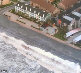
Anyone still on Galveston island is going to be in a world of hurt. This was the last good webcam Image I was able to get from downtown:

This location survived the 1900 storm, I hope it survives Ike.
| clyde w. |
| (Storm Tracker) |
| Fri Sep 12 2008 03:16 PM |
|
|
Alaberry,
You may be thinking of Isidore in 2002. The storm came into the Gulf as a category 4, hooked left into the northern Yucatan Penninsula where it weakened to a strong Tropical Storm. It moved north and made landfall in Louisiana with 70 mph winds, but was incredibly broad as it moved through the Gulf. Ike has reminded me of a much stronger version of this storm on its trek through the Gulf.
| madmumbler |
| (Storm Tracker) |
| Fri Sep 12 2008 03:22 PM |

|
|
|
TWC is showing Surfside Beach, TX is basically underwater already from early surge. Mike Sidell's report stated that except for a few sections and the main road, water has overtaken the I'm assuming it's an island, and they'll be pulling out over the bridge to the mainland shortly.
| MichaelA |
| (Weather Analyst) |
| Fri Sep 12 2008 03:56 PM |

|
|
|
I'm afraid that the major damage from Ike will be from the wide extent of the storm surge. With the center still well offshore, surge flooding has already begun from Louisiana to Galveston. A predicted 20 foot surge will easily breach the seawalls at Galveston and farther North at Port Arthur. This is going to be a devastating storm over a very large area.
|
MikeC
|
| (Admin) |
| Fri Sep 12 2008 04:04 PM |
|
|
Quote:
I'm afraid that the major damage from Ike will be from the wide extent of the storm surge. With the center still well offshore, surge flooding has already begun from Louisiana to Galveston. A predicted 20 foot surge will easily breach the seawalls at Galveston and farther North at Port Arthur. This is going to be a devastating storm over a very large area.
Yes, Ike is more a surge engine than a traditional hurricane,
The slosh for Ike is unreal, with even the ship canal near downtown Houston perhaps getting upwards of 20-27 feet of surge.
| MichaelA |
| (Weather Analyst) |
| Fri Sep 12 2008 04:13 PM |
|
|
|
|
Tides were 2 - 4 feet above normal along the West coast of FL yesterday on the back side and 400 miles from Ike's center. The entire GoM is being affected.
| Steve H1 |
| (Storm Tracker) |
| Fri Sep 12 2008 04:49 PM |
|
|
Hate to say this, but there are extremely cold cloud tops that are about to close a ring off around the core. This would seem to indicate that some strengthening is occurring, and we may see Cat 3 winds before this storm makes landfall. I wouildn't be surprised to see the eye clear out in the next couple of hours.....but I guess that's a moot point at this stage. Hope everyone gets out of the coastal areas.
| Beaumont, TX |
| (Storm Tracker) |
| Fri Sep 12 2008 05:17 PM |
|
|
There is water in Sabine Pass. There is concern the surge could top the levees in Port Arthur. Mid-County residents were told to leave so my brother-in-law is "hunkering" down here. Surge is the biggest concern with this storm. West end of Galveston is under water.
|
Ed Dunham
|
| (Former Meteorologist & CFHC Forum Moderator (Ed Passed Away on May 14, 2017)) |
| Fri Sep 12 2008 05:29 PM |
|
|
The weak center of Invest 91L was located yesterday near 22.1N 66.5W at 11/15Z. Today it is near 23.8N 70.9W at 12/17Z. Although the system continues to generate convection it is within a zone of windshear that is expected to increase, so development, if any, seems unlikely for awhile. The system is moving to the west northwest at 10 knots.
ED
| LoisCane |
| (Veteran Storm Chaser) |
| Fri Sep 12 2008 05:38 PM |

|
|
|
One of my real concerns is for places like Sabine Pass who have an illusion of safety. Flooding is widespread.
It may be more historic and mesmerizing on the live feeds on the front page (which I was watching at work) but it is going to happen in places without the press there to show and local agencies really have to get out the word in their towns.
Would be nice for some old timers from these places to post info if they have any... picture from Galveston downtown helped.
Water rides far in advance of the storm in this area... not something that happens as much in South Florida.
The way the beach and the sea slope off shore is a big issue in Galveston and that part of the world.
| Thunderbird12 |
| (Meteorologist) |
| Fri Sep 12 2008 06:14 PM |
|
|
Long range radar out of both Lake Charles and Houston indicates that Ike is attempting to form an eyewall, The would-be eyewall is still made up of various banding features at this point, but it is looking more organized that it did earlier.
Storm surge in excess of 8 feet has already been reported around Cameron, LA and in the Galveston area.
edit: Storm surge of 8.3 feet has also been recently reported at Sabine Pass.
| threw-er-back |
| (Registered User) |
| Fri Sep 12 2008 06:37 PM |
|
|
http://www.foxnews.com/video2/live.html?chanId=2
Live feed from Galveston
|
MikeC
|
| (Admin) |
| Fri Sep 12 2008 06:38 PM |
|
|
Live feed link is already on the main page, but you can see all the local news broadcast at once here: http://flhurricane.com/ikecoverage.html
Ike does look like it is again attempting to strengthen.
The storm surge is affecting a large area, just to emphasize this...
From New Orleans NWS:
50 FOOT BREECH OF A PRIVATE LEVEE NEAR SCARSDALE.
| DougBaker |
| (Verified CFHC User) |
| Fri Sep 12 2008 06:53 PM |
|
|
if you want to monitor police and other operations.
http://tx.scanamerica.us/index.php?county=Galveston
| MichaelA |
| (Weather Analyst) |
| Fri Sep 12 2008 06:56 PM |
|
|
|
|
I cannot believe that people have not evacuated from the coast yet! I'd have been long gone by now!
|
danielw
|
| (Moderator) |
| Fri Sep 12 2008 07:33 PM |

|
|
|
They never saw the Surge pictures from Katrina. The levee breaks got all of the coverage.
Estimates are that just over half of Galveston Island's 60,000 resdients have evacuated.
That would leave 30,000 people on the island. A 10% death rate would make the Katrina and Rita Death Toll insignificant.
A 10 to 15 feet surge with 18 foot waves on top of the Surge will destroy most of the wooden structures and a large number of commercial structures.
If you are in Texas and can see the Beach from where you are. Either Get Higher or Get Out NOW
Emergency Services will shut down as soon as sustained 30mph winds are in Galveston. The duration of winds greater than 30mph will be at least 12 hours and possibly 18 hours based on current storm track and speed.
|
danielw
|
| (Moderator) |
| Fri Sep 12 2008 07:38 PM |
|
|
|
|
This is long but it loads faster for those on dialup. Sorry for the length.
BRAZORIA-CHAMBERS-GALVESTON-HARRIS-JACKSON-LIBERTY-MATAGORDA-
132 PM CDT FRI SEP 12 2008
...HURRICANE WARNING REMAINS IN EFFECT...
...NEW INFORMATION...
UPDATED PRECAUTIONARY/PREPAREDNESS SECTION.
UPDATED STORM SURGE AND STORM TIDE SECTION.
UPDATED WINDS SECTION.
...AREAS AFFECTED...
THIS STATEMENT RECOMMENDS ACTIONS TO BE TAKEN BY PERSONS IN THE
FOLLOWING COUNTIES OR MARINE AREAS:
BRAZORIA...CHAMBERS...GALVESTON...HARRIS...JACKSON...LIBERTY...
MATAGORDA.
...WATCHES/WARNINGS...
PLEASE LISTEN TO NOAA WEATHER RADIO OR GO TO WEATHER.GOV ON THE
INTERNET FOR MORE INFORMATION ABOUT THESE ADDITIONAL HAZARDS.
FLOOD WATCH.
...PRECAUTIONARY/PREPAREDNESS ACTIONS...
IT IS IMPERATIVE THAT PERSONS WHO LIVE IN MOBILE HOMES OR POORLY-
BUILT STRUCTURES EVACUATE TO A SAFER LOCATION SUCH AS A WELL BUILT
HOME. PERSONS WHO LIVE IN HIGH RISES SHOULD CONSIDER EVACUATING AS
WINDS CAN BE AS MUCH AS 20 TO 30 MPH STRONGER AT THE TOP OF A HIGH
RISE THAN AT GROUND LEVEL. PERSONS OUTSIDE OF THE MANDATORY EVACUATION
AREAS WHO HAVE NOT EVACUATED SHOULD PLAN TO SHELTER IN PLACE IN A
WELL BUILT STRUCTURE DURING THE PERIOD OF TROPICAL STORM FORCE
WINDS.
CURRENT EVACUATION INFORMATION:
BRAZORIA COUNTY:
MANDATORY EVACUATIONS HAVE BEEN ORDERED FOR THE ENTIRE COUNTY
WITH THE EXCEPTION OF THE CITIES OF PEARLAND...ALVIN...MANVEL...
AND ANGLETON WHICH ARE UNDER A VOLUNTARY EVACUATION.
CHAMBERS COUNTY:
A MANDATORY EVACUATION HAS BEEN ORDERED FOR THE ENTIRE COUNTY
EFFECTIVE IMMEDIATELY.
GALVESTON COUNTY:
POWER OUTAGES HAVE BEEN REPORTED ON THE BOLIVAR PENINSULA.
A MANDATORY EVACUATION HAS BEEN ORDERED FOR ALL OF GALVESTON
ISLAND.
A MANDATORY EVACUATION IS IN EFFECT FOR BOLIVAR PENINSULA...
OMEGA BAY...SAN LEON...BACLIFF...FREDDIESVILLE...TIKI ISLAND...
KEMAH...AND CLEAR LAKE SHORES.
THE GALVESTON-BOLIVAR FERRY HAS CEASED OPERATIONS.
THE BOLIVAR S.U.D. HAS INDICATED THEY HAVE CEASED WATER SERVICE
TO THE PENINSULA.
HARRIS COUNTY:
A MANDATORY EVACUATION HAS BEEN ORDERED FOR THE FOLLOWING ZIP
CODES...77058...77059...77062...77520...77546...77571...77586...
77598 AND 77507.
PERSONS THROUGHOUT HARRIS COUNTY THAT LIVE IN MOBILE HOMES OR
HIGH RISES SHOULD CONSIDER EVACUATING DUE TO THE HIGH THREAT OF
DAMAGING WINDS.
FOR RESIDENTS WITH SPECIAL NEEDS...PLEASE CALL 311.
SOUTHWEST AIRLINES HAS SUSPENDED FLIGHTS INTO AND OUT OF HOBBY
AIRPORT UNTIL FURTHER NOTICE.
JACKSON COUNTY:
A MANDATORY EVACUATION HAS BEEN ORDERED FOR THE ENTIRE COUNTY.
SCHOOLS WILL BE CLOSED TODAY.
MATAGORDA COUNTY:
A MANDATORY EVACUATION HAS BEEN ORDERED FOR THE ENTIRE COUNTY.
PALACIOS SCHOOL DISTRICT WILL REMAIN CLOSED ON MONDAY SEPTEMBER
15TH.
...STORM SURGE AND STORM TIDE...
TIDE LEVELS REPORTED AT 1230 PM CDT:
HOUSTON SHIP CHANNEL/BATTLESHIP TEXAS - 4.7 FEET
CLEAR LAKE ENTRANCE - 4.6 FEET
ROLLOVER PASS - 5.4 FEET
EAGLE POINT - 5.9 FEET
MORGANS POINT - 5.1 FEET
NORTH JETTY - 7.7 FEET
PIER 21 - 6.8 FEET
PLEASURE PIER - 8.9 FEET
FREEPORT - 7.4 FEET
PORT O'CONNOR - 3.6 FEET
WATER LEVELS WILL BEGIN RISING VERY RAPIDLY LATE THIS AFTERNOON
WITH WATER LEVELS PEAKING BETWEEN 11 PM AND 3 AM TONIGHT AS THE
STORM SURGE SPREADS ONTO THE COAST AND BAYSHORE AREAS. MAXIMUM
STORM TIDE LEVELS ARE HIGHLY DEPENDENT ON THE TRACK OF THE STORM
AND VARIATIONS IN THE TRACK OF ONLY 15 MILES CAN MAKE DIFFERENCES
OF SEVERAL FEET MORE OR LESS FROM SOME OF THESE VALUES.
MAXIMUM WATER LEVELS FORECAST:
SHORELINE OF GALVESTON BAY...15 TO 22 FEET
BOLIVAR PENINSULA...17 TO 20 FEET
GALVESTON ISLAND......14 TO 17 FEET
GULF-FACING COASTLINE FROM SARGENT TO
SAN LUIS PASS...8 TO 14 FEET
GULF-FACING COASTLINE WEST OF SARGENT...4 TO 7 FEET
SHORELINE OF MATAGORDA BAY...3 TO 5 FEET
SEVERE INUNDATION IS LIKELY NEAR THE IMMEDIATE COAST AND BAYSHORE
AREAS!
NEIGHBORHOODS THAT ARE AFFECTED BY THE STORM SURGE...AND POSSIBLY
ENTIRE COASTAL COMMUNITIES...WILL BE INUNDATED DURING THE PERIOD
OF PEAK STORM TIDE. MANY RESIDENCES OF AVERAGE CONSTRUCTION
DIRECTLY ON THE COAST WILL BE DESTROYED. WIDESPREAD AND
DEVASTATING PERSONAL PROPERTY DAMAGE IS LIKELY ELSEWHERE. VEHICLES
LEFT BEHIND WILL LIKELY BE SWEPT AWAY. NUMEROUS ROADS WILL BE
SWAMPED...SOME MAY BE WASHED AWAY BY THE WATER. ENTIRE FLOOD PRONE
COASTAL COMMUNITIES WILL BE CUTOFF. WATER LEVELS MAY EXCEED 9 FEET
FOR MORE THAN A MILE INLAND. COASTAL RESIDENTS IN MULTI-STORY
FACILITIES RISK BEING CUTOFF. CONDITIONS WILL BE WORSENED BY
BATTERING WAVES CLOSER TO THE COAST. SUCH WAVES WILL EXACERBATE
PROPERTY DAMAGE...WITH MASSIVE DESTRUCTION OF HOMES...INCLUDING
THOSE OF BLOCK CONSTRUCTION. DAMAGE FROM BEACH EROSION COULD TAKE
YEARS TO REPAIR.
HIGH TIDE TIMES:
MORGANS POINT...
FRI 2:52 PM.
SAT 2:59 PM.
CLEAR LAKE ENTRANCE...
SAT 10:43 AM.
EAGLE POINT...
SAT 8:32 AM.
PORT BOLIVAR...
FRI 1:52 PM.
SAT 4:52 AM.
SAT 3:00 PM.
GALVESTON CHANNEL...
FRI 1:38 PM.
SAT 4:38 AM.
SAT 2:46 PM.
GALVESTON PLEASURE PIER...
SAT 3:32 AM.
SAT 1:40 PM.
JAMAICA BEACH...
FRI 4:16 PM.
SAT 7:16 AM.
SAT 5:24 PM.
SAN LUIS PASS...
FRI 1:29 PM.
SAT 4:29 AM.
SAT 2:37 PM.
FREEPORT...
SAT 3:54 AM.
SAT 2:02 PM.
PORT O CONNOR...
SAT 2:01 PM.
NOTE...TIDE LEVELS ARE REFERENCED FROM THE MEAN LOWER LOW WATER.
...WINDS...
THE WIND FIELD SURROUNDING IKE IS UNUSUALLY LARGE. TROPICAL STORM
FORCE WIND GUSTS IN EXCESS OF 39 MPH ARE EXPECTED TO REACH THE
COASTAL COUNTIES IN THE NEXT FEW HOURS...AND SPREAD INLAND TO THE
HOUSTON AREA BY LATE THIS AFTERNOON. WINDS OF AT LEAST TROPICAL
STORM FORCE WILL LAST UP TO 24 HOURS.
HURRICANE FORCE WINDS IN EXCESS OF 74 MPH WILL REACH THE COASTAL
COUNTIES LATE THIS EVENING. THESE WINDS WILL SPREAD INLAND THROUGH
THE HOUSTON METRO AREA BETWEEN MIDNIGHT AND 3 AM CDT. HURRICANE
FORCE WINDS MAY LAST FOR UP TO 12 HOURS.
PEAK WIND GUSTS OF 90 TO 110 MPH WILL BE POSSIBLE ACROSS
HARRIS...LIBERTY...BRAZORIA...GALVESTON...AND CHAMBERS COUNTIES.
WIND GUSTS NEAR 115 MPH WILL BE POSSIBLE NEAR WHERE THE CENTER OF
THE STORM COMES ONSHORE.
VERY DANGEROUS WINDS WILL PRODUCE WIDESPREAD DAMAGE AND
DESTRUCTION OF MOBILE HOMES IS LIKELY.
STRUCTURAL DAMAGE WILL INCLUDE THE MAJORITY OF MOBILE HOMES BEING
SEVERELY DAMAGED. THOSE THAT SURVIVE WILL BE UNINHABITABLE UNTIL
REPAIRED. HOUSES OF POOR TO AVERAGE CONSTRUCTION WILL HAVE MAJOR
DAMAGE...INCLUDING PARTIAL WALL COLLAPSE AND ROOFS BEING LIFTED
OFF. MANY WILL BE UNINHABITABLE. WELL CONSTRUCTED HOUSES WILL
INCUR MINOR DAMAGE TO SHINGLES...SIDING...GUTTERS...AS WELL AS
BLOWN OUT WINDOWS. UP TO ONE QUARTER OF GABLED ROOFS WILL FAIL.
PARTIAL ROOF FAILURE IS EXPECTED AT INDUSTRIAL PARKS...ESPECIALLY
TO THOSE BUILDINGS WITH LIGHT WEIGHT STEEL AND ALUMINUM
COVERINGS. OLDER LOW RISING APARTMENT ROOFS MAY ALSO BE TORN
OFF...AS WELL AS RECEIVING SIDING AND SHINGLE DAMAGE. UP TO ONE
QUARTER OF ALL GLASS IN HIGH RISE OFFICE BUILDINGS WILL BE BLOWN
OUT. AIRBORNE DEBRIS WILL CAUSE DAMAGE...INJURY...AND POSSIBLE
FATALITIES.
NATURAL DAMAGE WILL INCLUDE ALL TREES WITH ROTTING BASES BECOMING
UPROOTED OR SNAPPED. NEARLY ALL LARGE BRANCHES WILL SNAP. BETWEEN
ONE QUARTER AND ONE HALF OF HEALTHY SMALL TO MEDIUM SIZED TREES
WILL BE SNAPPED OR UPROOTED...MOST COMMON WHERE THE GROUND IS
SATURATED. UP TO THREE QUARTERS OF NEWLY PLANTED GROUND CROPS
WILL BE DAMAGED.
...INLAND FLOODING...
A FLOOD WATCH IS IN EFFECT THROUGH SATURDAY NIGHT.
RAIN BANDS ASSOCIATED WITH HURRICANE IKE WILL BEGIN SPREADING ONTO
THE UPPER TEXAS COAST THIS AFTERNOON AND THROUGH THE HOUSTON METRO
AREA BY EARLY THIS EVENING.
WIDESPREAD RAINFALL OF 5 TO 7 INCHES WITH ISOLATED TOTALS OF 10
TO 12 INCHES WILL BE POSSIBLE THROUGH THE DURATION OF THE STORM.
SIGNIFICANT FLOODING WILL BE POSSIBLE IN AREAS OF HEAVIEST
RAINFALL.
...TORNADOES...
THE THREAT FOR TORNADOES WILL INCREASE RAPIDLY BY THIS EVENING AND
CONTINUE THROUGH LATE SATURDAY AS IKE MOVES ONSHORE. YOU SHOULD
PLAN TO SEEK SHELTER IN AN INTERIOR ROOM ON THE LOWEST FLOOR AWAY
FROM WINDOWS.
...NEXT UPDATE...
THE NEXT LOCAL STATEMENT WILL BE ISSUED AROUND 530 PM CDT.
|
MikeC
|
| (Admin) |
| Fri Sep 12 2008 07:42 PM |
|
|
Galveston Tidal data shows oceans at 10 feet right now. (This is not counting wave action)
Galveston Tidal Data
Ike is still on course to make landfall just south of Galveston, closer to Freeport, but it looks like Galveston will see the worst of the storm surge, unfortunately.
| Thunderbird12 |
| (Meteorologist) |
| Fri Sep 12 2008 09:06 PM |
|
|
Ike suddenly appears to have a large but rather well-defined eye on radar. Considering the apparent improved organization and the recent upward trend in convective intensity, it may be making a last minute attempt to strengthen. The next recon mission just got in there... HDOBs seem to indicate that the pressure may have dropped (though interpolated pressure readings should always be taken with a grain of salt), but no winds yet that would prompt an upgrade in the current intensity, given past trends.
The latest vortex message just came out, which confirms a 60-mile wide eye. Pressure is down slightly to 955 mb compared to the previous vortex message.
| LoisCane |
| (Veteran Storm Chaser) |
| Fri Sep 12 2008 09:19 PM |
|
|
|
|
such a good comment Daniel. So true..the levee failure took over the news and towns like Waveland that got devastated were barely covered except for a few seconds of video and the sign.
The surge with Katrina was past Camille's surge I believe.. there was flooding past I 10..
So... not sure when the last time a low lying area in America got a strong storm surge vs other damage.
| Thunderbird12 |
| (Meteorologist) |
| Fri Sep 12 2008 10:16 PM |
|
|
Well, the earlier well-defined large eyewall is less defined now and it looks like Ike is trying to form a smaller eyewall. The eye is becoming a little better defined on IR imagery, with very deep convection firing in the eastern semicircle.
The outer core of the storm is starting to move onshore now, so conditions should start deteriorating quickly.
| Scott3294 |
| (Registered User) |
| Fri Sep 12 2008 10:56 PM |
|
|
radar showing the new inner-eye really tightening up...that is impressive.
http://radar.weather.gov/radar.php?product=N0Z&rid=hgx&loop=yes
SP
| Ed in Va |
| (Weather Master) |
| Fri Sep 12 2008 11:04 PM |
|
|
TWC says the winds now 110...only 5 from a major.
| weather999 |
| (Weather Watcher) |
| Fri Sep 12 2008 11:08 PM |
|
|
Oh my goodness, people should have left, what a stupid move not to. I hope those estimates of 1/2 the people still there aren't true.
17 foot seawall is already falling victim to the storm in Galveston (CNN)
110 MPH now.
| LoisCane |
| (Veteran Storm Chaser) |
| Fri Sep 12 2008 11:17 PM |
|
|
|
|
If there is video or information on the seawall please post it here.
This channel has been following the waves at the seafall and the Yacht Basin Dry storage being on fire.
Water is still slamming into the seawall and I don't see anything crumbling. Been worried on it so would like more info, thanks.
http://abclocal.go.com/ktrk/livenow?id=6384042 (watch live here..)
There is a lot of flooding in Houston around areas close to bayous. Apartment condo parking lots getting flooded though not inside structures.
This is the story of Ike... water across a tremendous area not just the island of Galveston.
| chitown |
| (Registered User) |
| Fri Sep 12 2008 11:17 PM |
|
|
Any chance we see rapid intensification right before landfall? It seems to be trying to get itself organized right before landfall.
| LoisCane |
| (Veteran Storm Chaser) |
| Fri Sep 12 2008 11:20 PM |
|
|
|
|
looks odd on radar... the eye wall seems to be retreating as it rebuilds as it contracts (if that is what it is doing, but it is changing tremendously)
http://radar.weather.gov/radar.php?product=N0Z&rid=hgx&loop=yes
The old area that was open is now filing in so landfall would be delayed officially I suppose.
I don't see any great intensification, perhaps someone else here does but I don't. This storm has been about as steady as it gets.
| Scott3294 |
| (Registered User) |
| Fri Sep 12 2008 11:20 PM |
|
|
I think we have already gotten confirmation of strengthening from the National Hurricane Center. They commented in their 6pm CDT statement that winds are up to 110 and they could go higher. Clearly the radar is showing that the storm is wrapping in tighter, but fortunately it looks like it is too close to really bomb out.
| weather999 |
| (Weather Watcher) |
| Sat Sep 13 2008 12:19 AM |
|
|
Quote:
If there is video or information on the seawall please post it here.
This channel has been following the waves at the seafall and the Yacht Basin Dry storage being on fire.
Water is still slamming into the seawall and I don't see anything crumbling. Been worried on it so would like more info, thanks.
http://abclocal.go.com/ktrk/livenow?id=6384042 (watch live here..)
There is a lot of flooding in Houston around areas close to bayous. Apartment condo parking lots getting flooded though not inside structures.
This is the story of Ike... water across a tremendous area not just the island of Galveston.
Sorry, didn't word that right.
Water was just about flowing over the 17 foot seawall.
nothing is crumbling.
Far too late to get out now, hopefully people will get through Ike.
| damejune2 |
| (Storm Tracker) |
| Sat Sep 13 2008 12:29 AM |

|
|
|
I was watching a live feed from a link provided on this site by Mike C and one of the local news networks in Houston said 40% of the residents of Galveston and surrounding areas remained behind to ride out the storm. That is just ludicrous considering the interstates and other roads out of the area were clear/traffic and water free not even 12 hours ago...why would people risk their lives for material items? Parts of Galveston were already inundated by water at noontime...my goodness...god bless those who stayed behind!
| stormchaserSteve |
| (Registered User) |
| Sat Sep 13 2008 12:37 AM |
|
|
|
I`m gonna go out on a limb here and say we will see 115 winds in the next 2 hours. That will match the storm surge we are seeing.
This is only the 5th hurricane I`ve tracked and I love it. I only track the big or unusual ones. I`m waiting on the tornados to develop as I`m sure we`ll see a few before the night is over.
Tone it down a bit. This is not funny.
| cieldumort |
| (Moderator) |
| Sat Sep 13 2008 12:43 AM |

|
|
|
Quote:
I`m gonna go out on a limb here and say we will see 115 winds in the next 2 hours. That will match the storm surge we are seeing.
Ike may easily be classified as a Cat 3 prior to making landfall, but the exact Saffir-Simpson number does not have nearly as much to do with the storm surge this time. Ike is an exceptionally large hurricane, whose storm surge is likely to be on a level more typically seen in a Cat 4 or Cat 5.
| prairiecomm |
| (Registered User) |
| Sat Sep 13 2008 12:58 AM |
|
|
foxnews.com has an live video feed that is still, as of 7:59 cdt, running.
it's right on the shore behind the seawall in galvaston, so you are looking across the roadway and seawall at the water beyond - there's a light that goes on and off, it seems to be out for good, now - but still interesting. this video must be indoors since it is still functional - the others on roofs were out some time ago
you can see the force of the wind on the palms
go to foxnews.com and click on live video stream - its the one for galveston coastline
| SeaMule |
| (Weather Hobbyist) |
| Sat Sep 13 2008 12:58 AM |

|
|
|
A good friend of mine is about an hour and a half north of ground zero...so far...nothing heavy to report...they have power and all. However....their dad owns two beach homes on Bolivar Peninsula.....which should take the storm surge...I'm guessing Katrina-like....
There is no way...after what we all have read about the power of this storm...that i think any of us would have stayed...right?
Perhaps the report that it was a cat 2 was a bit misleading! They need another way of catergorizing these!!!!!!! then, more would have left galveston......
too late now
| stormchaserSteve |
| (Registered User) |
| Sat Sep 13 2008 12:59 AM |
|
|
|
|
Looks like the eye is opening back up. May not make a 3 after all?
|
MikeC
|
| (Admin) |
| Sat Sep 13 2008 01:00 AM |
|
|
Power has gone out to Galveston island in general, none of the webcams (except Mark Sudduth's... but it's pitch black) are recording now, I did add a Level 3 Radar Recording from HCW Here. Though.
The multi coverage link at http://flhurricane.com/ikecoverage.html is still up and working, however.
Folks in the upper texas coast, and Lousiana it's going to be a long night. God bless you all and we sincerely hope you and those you know and love have decided the right way in evacuations and preparations.
| prairiecomm |
| (Registered User) |
| Sat Sep 13 2008 01:03 AM |
|
|
have been watching this feed on and off for several hours - the progression is intense - and obviously, it's going to get much worse. that emergency vehicle just drove up - could be a fox news car
in the video you are actually looking across a parking lot, past a row of hedge, low wall and palms, across the roadway/seawall and then the water beyond
J
| prairiecomm |
| (Registered User) |
| Sat Sep 13 2008 01:14 AM |
|
|
well, a tree must have come down in front of the video because it's obscured now - and it's been changed to nothing in particular ...
| cieldumort |
| (Moderator) |
| Sat Sep 13 2008 01:17 AM |
|
|
|
|
Now in addition to reforming an eyewall and tightening up, pressures have resumed falling. At 110MPH, there is more than enough time left for Ike to go Cat 3 - perhaps even mid-range Cat 3, prior to, or going in to landfall. An argument could be made that high-end 3 is not entirely out of the question. Given the very healthy upper-level pattern in the northwest quadrant that has replaced the shear and dry air, strengthening up to and into landfall is a pretty good bet. But whatever Saffir-Simpson number Ike officially makes landfall at, a 15-25 foot water rise/surge, along and a bit east of the eye, is already baked in the cake.
Product: Air Force Vortex Message (URNT12 KNHC)
Transmitted: 13th day of the month at 01:00Z
Aircraft: Air Force Aircraft (Last 3 digits of the tail number are 304)
Storm Number & Year: 09L in 2008
Storm Name: Ike (in the North Atlantic basin)
Mission Number: 33
Observation Number: 22
A. Time of Center Fix: 13th day of the month at 0:46:00Z
B. Center Fix Coordinates: 28°21'N 94°14'W (28.35N 94.2333W) (View map)
B. Center Fix Location: 74 miles (119 km) to the SSE (151°) from Galveston, TX, USA.
C. Minimum Height at Standard Level: 2,703m (8,868ft) at 700mb
D. Estimated (by SFMR or visually) Maximum Surface Wind: 82kts (~ 94.4mph)
E. Location of the Estimated Maximum Surface Wind: 22 nautical miles (25 statute miles) to the NW (318°) of center fix
F. Maximum Flight Level Wind Inbound: From 35° at 89kts (From the NE at ~ 102.4mph)
G. Location of Maximum Flight Level Wind Inbound: 27 nautical miles (31 statute miles) to the NW (316°) of center fix
H. Minimum Sea Level Pressure: 952mb (28.11 inHg)
I. Maximum Flight Level Temp & Pressure Altitude Outside Eye: 9°C (48°F) at a pressure alt. of 3,041m (9,977ft)
J. Maximum Flight Level Temp & Pressure Altitude Inside Eye: 17°C (63°F) at a pressure alt. of 3,047m (9,997ft)
K. Dewpoint Temp (collected at same location as temp inside eye): 14°C (57°F)
K. Sea Surface Temp (collected at same location as temp inside eye): Not Available
L. Eye Character: Open in the east (center has 50% or more, but less than 100%, of eyewall coverage)
M. Eye Shape: Elliptical (oval shaped)
M. Orientation of Major Axis in Elliptical Eye: 40° to 220° (NE to SW)
M. Length of Major Axis in Elliptical Eye: 60 nautical miles (69 statute miles)
M. Length of Minor Axis in Elliptical Eye: 40 nautical miles (46 statute miles)
N. Fix Determined By: Penetration, Radar, Wind, Pressure and Temperature
N. Fix Level: 700mb
O. Navigation Fix Accuracy: 0.02 nautical miles
O. Meteorological Accuracy: 1 nautical mile
Remarks Section:
Maximum Flight Level Wind: 103kts (~ 118.5mph) in the northeast quadrant at 23:36:00Z
| Thunderbird12 |
| (Meteorologist) |
| Sat Sep 13 2008 03:29 AM |
|
|
Ike is displaying some interesting features this evening. The innermost eye wall appears to be somewhat unstable, as there are several small-scale circulations rotating around in there. These circulations generally seem to be weak, but the stronger ones could locally enhance the winds in their vicinity. The main outer band has been expanding in both directions, leaving an increasing precip-free area outside of the inner eyewall.
The complex inner dynamics will lead to a wobbly approach to the coast. it is often said to not focus too much on the exact track, especially with a large storm like Ike, but when it comes to potential impacts on the Galveston/Houston area, now is the time to obsess over every single wobble or potential change in direction. A slight deviation either way will make a huge difference when it comes to storm surge impact near the center. Right now, Ike seems to be headed for a landfall a little south of Galveston, which would be bad news for that area.
| Allison |
| (Weather Guru) |
| Sat Sep 13 2008 05:05 AM |

|
|
|
Local news (KHOU) is reporting that the storm surge is up to the top of the Galveston Seawall -- about 15-17 feet high. Earlier today, Galveston-area residents were saying that it was already higher than Carla or Alicia.... One family interviewed was planning on staying, and had bought life jackets...

Here in far west Houston, we're getting strong gusts, but still within TS strength... rain just started... we still have power and no apparent damage.
| flahurricane |
| (Weather Hobbyist) |
| Sat Sep 13 2008 05:22 AM |
|
|
Quote:
Local news (KHOU) is reporting that the storm surge is up to the top of the Galveston Seawall -- about 15-17 feet high. Earlier today, Galveston-area residents were saying that it was already higher than Carla or Alicia.... One family interviewed was planning on staying, and had bought life jackets...
Here in far west Houston, we're getting strong gusts, but still within TS strength... rain just started... we still have power and no apparent damage.
You in west Houston are just now starting to get the outer bands of Ike. You've got a lot more coming. I'd expect widespread power outages in the next few hours.
| cieldumort |
| (Moderator) |
| Sat Sep 13 2008 05:23 AM |
| Attachment |
|
|
|
|
Ike continues to organize into landfall, with the once 70 mile-wide center of circulation continuing to contract. Outflow is far superior in all quadrants than just about at any other time in Ike's entire lifespan, thus far; and while not especially warm to much depth, ocean temps along the upper Texas coast are quite a bit warmer than the ocean temps along the eastern half of Louisiana as Gustav came in.
Have uploaded a recent water vapor image highlighting Ike's excellent breathing.
An additional threat to those who are going to be experiencing the actual eyewall: The eye has been displaying embedded swirls all night, with several vortices noted within the innermost portions of the eyewall. This is indicative of an eyewall experiencing a lot of turbulence, and the kind of twisting and turning often very capable of quickly spinning up numerous EF-0 and EF-1 tornadoes without warning.
| Allison |
| (Weather Guru) |
| Sat Sep 13 2008 05:46 AM |
|
|
|
|
For those familiar with Houston -- KHOU reporting that Brennan's Restaurant in downtown has burned down, and now they're trying to keep the fire from spreading to other buildings.
| Thunderbird12 |
| (Meteorologist) |
| Sat Sep 13 2008 05:47 AM |
|
|
It is remarkable how Ike has reorganized in the last 12 hours or so. Thankfully, it has not had time to reconsolidate the wind field, which is still very large and broad. Surface winds (based on SFMR and dropsondes) remain lower than you might expect given the flight-level winds, which is keeping Ike below cat 3 status. Whether or not Ike makes cat 3 before landfall is strictly academic at this point.
Ike continues to wobble toward the coast. It wobbled a bit to the north a little earlier and the center now appears headed toward the city of Galveston proper, on the north side of Galveston island. Any further movement to the north would probably be a good thing, but much of the damage is already done at this point.
| Raymond |
| (Weather Guru) |
| Sat Sep 13 2008 05:58 AM |
|
|
The surge near Galveston is currently 12 feet high and strongly raising, but the sligth northward jog of the storm center should take the worst of the surge away from there more to areas eastward.
| cieldumort |
| (Moderator) |
| Sat Sep 13 2008 06:21 AM |
|
|
|
|
Houston is now picking up winds over 100mph.
Sabine has just recorded 74mph sustained. Mike Bettes (TWC) just recorded a 101mph gust quickly after a 98mph gust - in Houston (Clear Lake) - at an arm's-length elevation of six or seven feet, which would reasonably equate to about 110mph at the standard measuring elevation of 10 meters.
| Raymond |
| (Weather Guru) |
| Sat Sep 13 2008 07:24 AM |
|
|
This is good news for the storm surge in this area, which is currently a bit above 12 feet. Most likely it`ll stay below the high predictions and also below the sea wall hight at Galveston!
It´s of course also bad news for the areas more to the east of the landfall location, which will get the worst of surge and wind.

| Jane219ga |
| (Registered User) |
| Sat Sep 13 2008 09:27 PM |

|
|
|
Just wondering if this place is running okay today. Please put it graveyard if need be but no posts since 8:28AM is kind of unsettling.
| JonB |
| (Registered User) |
| Sun Sep 14 2008 12:56 AM |

|
|
|
at 9:17 yesterday Ike had a reading 952 mb.
I have found numerous hurricanes that were 3 on the Saffir-Simpson scale with minimum pressures of 952, 953, 954. Very lucky the winds with Ike never caught up to his minimum pressure.
|
Ed Dunham
|
| (Former Meteorologist & CFHC Forum Moderator (Ed Passed Away on May 14, 2017)) |
| Sun Sep 14 2008 01:04 AM |
|
|
Thanks for your concern, but we are fine and the 'quiet period' is normal. CFHC is primarily a site for tracking tropical cyclones in the Atlantic basin and for 'getting the word out' whenever a storm should threaten an area. I suspect that a lot of our contributors (and a big 'Thank You' to all of them) were up long into the wee hours of this morning monitoring the progress of Ike as the hurricane approached the Galveston area. Ike will soon become a Tropical Depression as the storm moves into southwestern Arkansas later this evening. Invests 91L and 92L are both not expected to develop - at least not for the next few days - since both Invest areas will be under the influence of strong windshear. So there really isn't anything to track for the moment and I'd guess that everyone is getting some well deserved rest. In the next couple of days we should all get a better idea of the scope of the damage that was inflicted by Ike and of the magnitude of the recovery effort.
ED
| M.A. |
| (Weather Guru) |
| Sun Sep 14 2008 03:18 PM |
|
|
I dont know if it is a mistake or not, Is Ike forcasted to become a storm again??? Looking at the forecast it has it upgraded to a storm in Canada. Is this possible? Or is that where the Canadian goverment takes over from the NHC?
It looks like we are going into a SLOWER period. I think everyone is in need of a little break. I would like to once again thank the mods and mets here for the spot on commentary.
|
Ed Dunham
|
| (Former Meteorologist & CFHC Forum Moderator (Ed Passed Away on May 14, 2017)) |
| Sun Sep 14 2008 08:24 PM |
|
|
The system that was Ike is expected to strengthen again - but as an extratropical system, i.e., no longer tropical in nature. From the last NHC Discussion bulletin issued this morning:
"IKE WILL LOSE TROPICAL CHARACTERISTICS DURING THE NEXT 24
HOURS AS IT MERGES WITH THE FRONT. SOME RE-INTENSIFICATION IS
EXPECTED AFTER EXTRATROPICAL TRANSITION IS COMPLETE"
Cheers,
ED
| hurricf |
| (Registered User) |
| Sun Sep 14 2008 10:28 PM |
|
|
Galveston reporter Video
www.worldwidemeteo.com
| saltysenior |
| (Verified CFHC User) |
| Mon Sep 15 2008 04:18 PM |
|
|
Galv. tidal link on this site showed a peak recorded wind of 54 knts nne at about 2:am that morning at "Galv.Pleasure Pier''.......tv and others say 110......that's a big difference........... tide gauge recorded +13ft...that jives,but what's with the wind reports????
|
MikeC
|
| (Admin) |
| Mon Sep 15 2008 07:35 PM |
|
|
After a reprieve from Ike, here is a good collection of photos from around the area Link here. #11 especially reflects the event for me. Best to all those in the area, help is on the way from here as well.
|
MikeC
|
| (Admin) |
| Tue Sep 16 2008 05:26 PM |
|
|
Here is a google earth overlay with aerial photos of Ike damage
| LoisCane |
| (Veteran Storm Chaser) |
| Fri Sep 19 2008 01:16 AM |
|
|
|
|
There's a part of me that will always think of Ike as Invest 97. When reading what was written here .. written well too it made me remember a lot on the beginnings of Ike and many of this season's storms that have come together and been "late bloomers" vs Cat 2s and 3s crossing the Atlantic.
With a wave down in the Carib it behooves us to all remember that as this seems to the year where storms form on our side of the world.
Yup... Invest 97.
| flahurricane |
| (Weather Hobbyist) |
| Fri Sep 19 2008 04:03 AM |
|
|
Never underestimate mother nature.
Gilchrist, TX and Crystal Beacha are gone.
http://coastal.er.usgs.gov/hurricanes/ik...h_TX_Loc1LG.jpg
| LoisCane |
| (Veteran Storm Chaser) |
| Fri Sep 19 2008 07:41 PM |
|
|
|
|
Interesting actually to look at that image and see where the structures remain. I wonder how many feet in that is... how much of a mile (fractions) and if the land there has an incline away from the beach.
Homes built on the beach line are not surprisingly washed away but a bit surprised actually so much survived further on the other side.
Am sure they are very damaged either way.
Thanks for the reminder... those of us in Florida (and Texas and Alabama..and...) need to remember.
|
danielw
|
| (Moderator) |
| Sat Sep 20 2008 12:22 PM |
|
|
|
|
TROPICAL WEATHER OUTLOOK
NWS TPC/NATIONAL HURRICANE CENTER MIAMI FL
800 AM EDT SAT SEP 20 2008
FOR THE NORTH ATLANTIC...CARIBBEAN SEA AND THE GULF OF MEXICO...
A WESTWARD-MOVING TROPICAL WAVE...ACCOMPANIED BY A SURFACE LOW
PRESSURE SYSTEM OVER THE EASTERN CARIBBEAN SEA...IS PRODUCING
WIDESPREAD CLOUDINESS AND SHOWERS OVER THE LESSER ANTILLES...AND
ADJACENT CARIBBEAN AND ATLANTIC WATERS. THIS SYSTEM IS SHOWING
SIGNS OF IMPROVED ORGANIZATION THIS MORNING...AND UPPER-LEVEL WINDS
ARE EXPECTED TO BECOME SOMEWHAT MORE FAVORABLE OVER THE NEXT COUPLE
DAYS FOR SOME ADDITIONAL DEVELOPMENT TO OCCUR.
A BROAD AREA OF LOW PRESSURE...ACCOMPANIED BY DISORGANIZED SHOWER
ACTIVITY...CONTINUES OVER THE SOUTHWESTERN CARIBBEAN SEA JUST EAST
OF NICARAGUA. UPPER-LEVEL WINDS ARE CURRENTLY UNFAVORABLE FOR ANY
SIGNIFICANT DEVELOPMENT TO OCCUR.
ELSEWHERE...TROPICAL CYCLONE FORMATION IS NOT EXPECTED DURING THE
NEXT 48 HOURS.
$$
FORECASTER STEWART
| tcurtis |
| (Registered User) |
| Sun Oct 19 2008 01:11 AM |
|
|
Hi there Mike C,
I'm searching for documented figures on the maximum storm surges observed in Galveston's ship channel/bay at Pie r 21 and in the Gulf at the Pleasure Pier.
http://tidesandcurrents.noaa.gov/geo.shtml?location=8771341 asserts that a couple of hours before landfall, the maximum tide was 9.78 feet--this before the recording stations ceased to record.
What is your source for the peak surge at Galveston (and where in Galveston was it measured) & for Bolivar?
You quote: The "surge at Galveston was just over 12 feet, with higher peaks, but not as bad as it could have been had the storm passed just west. It appears, at least for the downtown, the seawall was a good investment as it kept things from getting too bad there. But still vast amounts of damage happened, including the destruction of the historic Balinese room and the Galveston Memorial Monument to the infamous 1900 Hurricane. Port Bolivar, across the bay east of Galveston, had a 23 ft surge."
Thanks much,
tcurtis