MikeC
|
| (Admin) |
| Wed Aug 23 2017 03:39 AM |
|
|
11:00PM CDT 25 August 2017 Update
Eye of Category 4 Harvey makes landfall between port aransas and Port O'Connor, TX. Early damage reports in Rockport, TX are extreme, an widespread. The eye is still slowly moving onshore, and the storm hasn't weakened yet.
Harvey's landfall on the Texas coast was over the northern end of San Jose Island about 4 miles east of Rockport.

6:00PM CDT 25 August 2017 Update
Recon has confirmed Category 4 winds in Harvey mere hours from landfall in the Middle Texas Coastline.

2:00PM CDT 25 August 2017 Update
Recon has found 120mph winds and a pressure of 943mb, making Harvey a major hurricane.
6:30AM CDT 25 August 2017 Update
Once landfall happens some models have it sitting inland near the coast until Monday, with potentially a second Texas landfall later in the week further north.
Recon continues to show pressure dropping, 946mb as of the latest pass. 951 with the latest dropsonde.
Those in the path of Harvey should have made preparations or evacuated if necessary yesterday. Those in the area check local national weather service and Media for more information for your particular area. There is a list of media on the main page of flhurricane.com below

12:30AM CDT 25 August 2017 Update
Recon has found that the more gradual lowering of barometric pressure and leveling off of wind that Harvey experienced yesterday may have come to an end, and the hurricane could be entering a new round of Rapid Intensification tonight.
Harvey remains forecast to become a high-end Cat 3 before landfall, but implicit in this is the possibility of Cat 4 between advisory times. Regardless of Category, it is very likely that Harvey will be a catastrophic hurricane on many levels, not the least of which will be the potential to produce biblical inland flooding over an extended duration, and possibly over extensive areas.
Efforts to protect life, loved ones and property along the coast and just inland should now be getting rushed to completion. Anyone who elects to stay behind may be unreachable by emergency services, and left to fend for themselves in what could very easily become nightmarish life-threatening conditions.
-Ciel
4:00PM CDT 24 August 2017 Update
Harvey still strengthening, and the Hurricane Warning has been extended northeast of Matagorda to Sargent Texas.
10:00AM CDT 24 August 2017 Update
Per NHC:
Harvey has intensified quickly this morning, and is now forecast to be a major hurricane at landfall, bringing life-threatening storm surge, rainfall, and wind hazards to portions of the Texas coast
.
Preparations to protect life and property should be completed by tonight, as tropical-storm-force winds will first arrive in the
hurricane and storm surge warning areas on Friday.
A Storm Surge Warning is in effect for much of the Texas coast. Life-threatening storm surge flooding could reach heights of 6 to 10 feet above ground level at the coast between the north entrance of the Padre Island National Seashore and Sargent.
Life-threatening flooding is expected across much of the Texas coast from heavy rainfall of 12 to 20 inches, with isolated amounts as high as 30 inches, from Friday through early next week. Please refer to products from your local National Weather Service office and the NOAA Weather Prediction Center for more information on the flooding hazard.
8:45AM CDT 24 August 2017 Update
Aircraft recon found 984 pressure, and a 16 nautical mile wide closed eye in Harvey. It's deepening quickly and winds will increase shortly after. Expect a hurricane today, and possibly a major hurricane at landfall.
Times will generally be in Central time because of the location of Harvey.
6:45AM CDT 24 August 2017 Update
Recon measured a 985mb pressure in Harvey which indicates a Hurricane, it seems to be going under rapid intensification now, which means Harvey will likely become a major before landfall. Those in the hurricane warning area should rush preparations now, and listen to local officials/media for local details.
6:30AM CDT 24 August 2017 Update
Harvey has strengthened slightly overnight and Recon has found potentially stronger winds that indicate Harvey could strengthen more today, possibly a hurricane later tonight or tomorrow. With that in mind, some new warnings have been issued:
Storm surge will likely be an issue in parts of the Texas coastline, therefore a Storm Surge Warning has been issued for the Texas coast from Port Mansfield to San Luis Pass.
Additionally a Storm Surge Watch has been issued from Port Mansfield south to
the Mouth of the Rio Grande.
A Hurricane Warning has been issued for the Texas coast from Port
Mansfield to Matagorda.
A Tropical Storm Warning has been issued from north of Matagorda
to High Island Texas
A Tropical Storm Warning and a Hurricane Watch has been issued from
south of Port Mansfield to the Mouth of the Rio Grande.
10AM CDT 23 August 2017 Update
Based on Recon, harvey has regenerated in the Gulf of Mexico as a Tropical Depression. The official forecast takes Harvey in as a Hurricane near Madagorda Midday on Friday.
Because of this,
A Storm Surge Watch has been issued for the coast of Texas from Port Mansfield to High Island, which includes Corpus Christi.
North fo that, a A Hurricane Watch has been issued for the coast of Texas from north of Port Mansfield to San Luis Pass. (just south of Houston)
A Tropical Storm Watch has been issued for the coast of Texas from the Mouth of the Rio Grande to Port Mansfield and from north of San Luis Pass to High Island.
The government of Mexico has issued a Tropical Storm Watch for the coast of Mexico from Boca De Catan to the Mouth of the Rio Grande.
Harvey is expected to slowly move into Texas, bringing extended periods of surge and wind, and extreme amounts of rainfall, starting tomorrow morning into Midday. If you are in the warning area make preparations now, and be prepared to be under bad conditions for a while as it is expected for Harvey to stall out and possibly move back into the Gulf. If you are in the warning area time to look to local media and officials for more pertinent information.
Conditions are right so that it is a good possibility that Harvey becomes a Major hurricane before landfall, category 3 or higher. So please please take this seriously if you live in the hurricane warning area.
edit: Recon found 985mb, which is enough for hurricane strength.
10AM CDT 23 August 2017 Update
Harvey is expected to slowly increase in strength at first, but increase more rapidly as it approaches the coastline, the forecast takes it in slowly and Harvey could wind up being a major flooding events for parts of Texas, Louisiana, and Mississippi. The National hurricane center calls out the fact this first forecast may change once motion and trends have established, so everyone in the watch area should be watching this system, and preparing. It is expected be an intensifying hurricane at landfall, and may do so quickly once near land.
Things may change rapidly with Harvey, so keep watch closely if you are in the watch/warning area and listen to local officials and media for the best information for your particular area.
Mark Sudduth from Hurricanetrack.com is on his way to Texas for Harvey, follow him at www.hurricanetrack.com
Original Update
The remnants of Harvey are very likely to regenerate in the Gulf, in fact the National Hurricane Center gives it a near 100% chance for development within the next 48 hours.
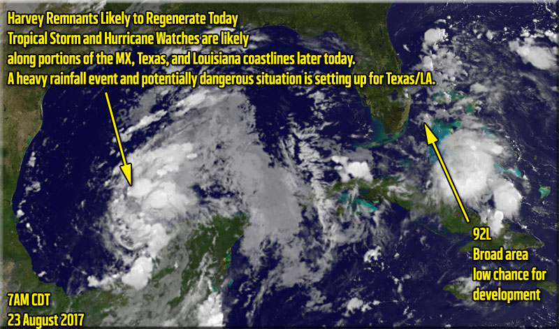
Those in northeastern Mexico to Louisiana should continue to monitor its progress as it could develop. Some models forecast it may landfall briefly then re-emerge into the Gulf, so those along the Gulf should monitor it even beyond the first landfall point. A strong Tropical storm or cat 1/2 hurricane is possible with the remnants of Harvey. if forward motion slows before landfall it could increase more than expected. Others suggest a single landfall, but slow moving, causing large amounts of rainfall,which ultimately may be Harvey's claim to fame.
Harvey's remnants have moved offshore and signs of an organized center are already occurring.
More information on Harvey remnants will come soon.
92L is currently a trough partially over Florida, but most of the rain is actually southwest of Florida this evening, it is not expected to develop into much, but could move back over Florida and develop in the Atlantic before heading out to sea, Worth Monitoring just in case something happens.
{{StormLinks|Harvey|09|9|2017|09|Harvey}}
{{StormLinks|92L|92|10|2017|92|92L (FL/Bahamas Low)}}
{{HoustonStormEventLinks}}
Harvey Related flhurricane recordings
{{TexasGulfRadar}}
{{EastFloridaRadar}}
{{NorthGulfRadar}}
| Nick Humphrey |
| (Meteorologist/Geographer) |
| Wed Aug 23 2017 06:30 AM |

|
|
|
I must say, for a system that hasn't even (re)developed yet, it's absolutely shocking to have such high degree of model agreement on scenarios. Somewhat equivalent to multiple independent medical tests giving you the same bad news. It certainly appear incredible amounts of rain may be the biggest story with the system. Obviously if the system drifts into LA, so does the torrential rain threat.

The heaviest total forecast rainfall from the latest 00Z GFS would be for Houston. However, as some may heave heard, even "lighter" heavy rain in New Orleans could be disastrous given their recent drainage problems.
With all that said, I do have some concerns about the actual intensity as well. Temps in the Gulf head of Harvey are running in the mid-80s and with much lighter shear than it is initially facing now.

I think it is realistic for it to quickly become a hurricane if develops an organized inner core quickly. Given trends (as of tonight) I am hopeful advisories are started very soon to get the alert out as the Texas Coast is also very surge prone...beyond wind damage problems.
|
MikeC
|
| (Admin) |
| Wed Aug 23 2017 11:52 AM |
|
|
The models runs are interesting on Harvey this morning, go see the Forecast Lounge for that.
Recon is out in the system currently and finding it a very wet area, and it may be upgraded this morning.
|
MikeC
|
| (Admin) |
| Wed Aug 23 2017 12:51 PM |
|
|
Recon found the closed circulation, advisories are very likely now at 10AM CDT (11AM EDT)
|
MikeC
|
| (Admin) |
| Wed Aug 23 2017 03:46 PM |
|
|
I want to point out the first forecast map after regeneration may be a little off until motion and trends are established. Those in the watch area need to start preparing now, if this slows down as expected, it may have more time to strengthen, or at the very least cause extended periods of time with heavy rain and wind.
| cieldumort |
| (Moderator) |
| Wed Aug 23 2017 03:55 PM |

|
|
|
First-ever operational Storm Surge Watch

|
MikeC
|
| (Admin) |
| Wed Aug 23 2017 09:31 PM |
|
|
3 recon planes are investigating Harvey this evening.
|
MikeC
|
| (Admin) |
| Thu Aug 24 2017 02:10 AM |
|
|
Recon isn't finding much in the way of lower pressures, so it's likely the storm will stay a depression at 11PM, tomorrow afternoon is when things may improve, especially if the center of the system becomes a bit more circular that it currently is. Battle of two ridges east and west leaves the gap of low steering currents, which one wins out determines if it goes more west or east (or dragged back into the Gulf)
The LLC may be a bit exposed tonight.
| cieldumort |
| (Moderator) |
| Thu Aug 24 2017 04:10 AM |
|
|
|
|
Internal processes and some external wind shear has kept intensity in check throughout the day Wednesday, but that may be changing. Recon and satellite data indicates that Harvey is strengthening tonight. With water temps in the GOM exceptionally warm, and shear increasingly more favorable, Harvey will likely have a mostly conducive environment for strengthening up through landfall, or maybe more than one, as indicted by some models.
Wind at recon flight level of about 2,400' elevation in the northeast quadrant is now running at or above 50 knots. Taken together with some reliable SFMR estimates of at least 35 knots at the surface, Harvey has become a tropical storm again.
|
MikeC
|
| (Admin) |
| Thu Aug 24 2017 11:50 AM |
|
|
Recon measured a 985mb pressure in Harvey which indicates a Hurricane, it seems to be going under rapid intensification now, which means Harvey will likely become a major before landfall. Those in the hurricane warning area should rush preparations now, and listen to local officials/media for local details.
| cieldumort |
| (Moderator) |
| Thu Aug 24 2017 11:56 AM |
|
|
|
|
Went to bed late last night telling friends that I am at a 40% chance Harvey becomes a Major, with Harvey at 1001mb, and just woke up to recon just finding 985mb. This is the type of tropical cyclone we are looking at here, folks.
Watch to see how well Harvey develops an inner core over the next 24 hours. If Harvey generates a solid inner core, which appears to be underway, his environment - ocean heat content, wind shear, humidity, etc. -> all very conducive for several phases of Rapid Intensification, and Harvey could become our first landfalling Major Hurricane since Wilma 11 years ago.
|
MikeC
|
| (Admin) |
| Thu Aug 24 2017 02:00 PM |
|
|
Aircraft recon found 984 pressure, and a 16 nautical mile wide closed eye in Harvey. It's deepening quickly and winds will increase shortly after. Expect a hurricane today, and possibly a major hurricane at landfall.
Times will generally be in Central time because of the location of Harvey.
| cieldumort |
| (Moderator) |
| Thu Aug 24 2017 02:21 PM |
|
|
|
|
Just a reminder, with Harvey undergoing RI and quite possibly becoming our first landfalling Major in over a decade, the Second Main Event is getting lost a bit in the media cycle.
To be plain, Harvey is likely going to be a high-end inland hurricane for longer than people realize, and only slowly weaken, wind-wise. What may not weaken much, if at all, will be Harvey's potential to create biblical rainfall, as the well-developed cyclone travels through a 'Brown Ocean,' that is Texas this year, and possibly tracks very slowly and/or stalls altogether and/or has one or more reemergence over the Gulf - Rainfall totals over wide areas may exceed 12", with localized totals possible in this set-up exceeding three feet. Three feet. This would likely result in several locations of severe, record-setting flooding, and countless other locations of major flooding.
For people well inland
>>> People living in any of Texas' most flood-prone locations that are within the entire cone of uncertainty should now be preparing to evacuate. Evacuating by Saturday, rather than waiting for the waters to block exits or come rushing to the front door, can save lives.
>>> People who live in portions of the state who only experience even rarely dangerous flooding, this means you should be paying very close attention, and at least consider evacuating by Saturday if you live within Harvey's entire cone of uncertainty.
>>> People who live within Harvey's core cone (and closer to the eyewall's expected track), who live in mobile homes or traditional structures but that are not sound, should begin planning to evacuate as well, especially so should Harvey become a major, which looks increasingly likely. An inland only slowly decaying Major Hurricane Harvey in this set-up could easily produce wind gusts in excess of 80MPH well inland, and possibly for an extended duration. Winds this strong can rip, flip or even destroy most mobile homes, and some traditional homes that are not structurally sound.
As always, these are personal opinions only. Please refer to your local NWS for official information.
The above time-tables are not my thoughts for people living right along, or closer to the coast, who would be wise to have evacuated by tomorrow morning.
|
MikeC
|
| (Admin) |
| Thu Aug 24 2017 02:35 PM |
|
|
Pressure now down to 981.5, winds have not caught up to the pressure drops yet.
|
MikeC
|
| (Admin) |
| Thu Aug 24 2017 03:41 PM |
|
|
Started to record Corpus Christi Radar
http://flhurricane.com/imageanimator.php?264
Other recording will pop up as it nears.
| Psyber |
| (Storm Tracker) |
| Thu Aug 24 2017 05:13 PM |

|
|
|
Sorry cieldumort, but I wanted to verify how the storm surge is being calculated now? Is it using a straight ESTIMATION of the surge or does it include NOAA buoy information as well? With or without, since Harvey is going to be spinning up so quickly, I'm predicting less storm surge as it'll have less time really push the surf.
That's one thing that doesn't seem to be included enough in almost every forum is plotting using direct NOAA buoy data. I'd love to be able to have every 5 square miles by 5 square miles calculations because it'd add a whole ton of tracking information.
Once you saw it hop over the Yucatan with those SST's and lack of sheer you could see it was going to really spin up.
The latest of 980mb barometer is going to make it a time version anything keeping it out to sea which isn't much at this point. Thankfully not enough to create a large a gigantic wind/storm surge field.
Does anyone think that the NHC is really protecting the movement to drop awfully fast once it hits land? If so it's going to drop an ungodly amount of rain(I see this more dangerous than storm surge) if mid to high-level sheer stalls once it lands.

| cieldumort |
| (Moderator) |
| Thu Aug 24 2017 05:26 PM |
|
|
|
|
Quote:
Sorry cieldumort, but I wanted to verify how the storm surge is being calculated now? Is it using a straight ESTIMATION of the surge or does it include NOAA buoy information as well? With or without, since Harvey is going to be spinning up so quickly, I'm predicting less storm surge as it'll have less time really push the surf. How is storm surge observed and measured?
From NHC (May not answer your question, which is probably best directed to @NHC)
Quote:
"Storm surge is water from the ocean that is pushed onshore by the force of the winds. Flooding from storm surge depends on many factors, such as the track, intensity, size, and forward speed of the tropical cyclone and the characteristics of the coastline where it comes ashore or passes nearby. These factors are difficult to predict far in advance of a tropical cyclone affecting a particular area."
Tide Stations (NOAA): A network of 175 long-term, continuously operating water level stations throughout the U.S. serving as the foundation for NOAA's tide prediction products and providing data for storm surge estimates.
Storm Surge Tide Station
NOAA Tide Station
Measure still water (e.g., no waves)
Traditionally most reliable
Limited stations
FEMA/USGS High Water Marks (HWM): These marks are lines found on trees and other structures marking the highest elevation (peak) of the water surface for a flood event created by foam, seed, or other debris. Survey crews are deployed after a storm to locate and record reliable HWMs. GPS methods are used to determine location for coastal HWMs, which are then mapped relative to a vertical reference datum such as NAVD88.
Storm Surge High Water
High Water Marks Inside A Building
Perishable
Traditionally best method for capturing highest surge
Subjective and often include impacts of waves
Pressure Sensors (USGS): These are temporary water-level and barometric-pressure sensors which provide information about storm surge duration, times of surge arrival/retreat, and maximum depths.
Storm Surge Pressure Sensor
USGS Pressure Sensor
Relatively new method
Deployed in advance of storms at expected location of highest surge
Can contain impacts of waves
With regard to Harvey's potential storm surge, it could have the potential to be greater than you'd expect, because the system will be drawing in the ocean for a long time - even once well inland.
|
MikeC
|
| (Admin) |
| Thu Aug 24 2017 07:06 PM |
|
|
Recon has it down to 977mb, still strengthening fairly rapidly.
|
danielw
|
| (Moderator) |
| Thu Aug 24 2017 08:53 PM |

|
|
|
Storm Surge is currently being forecast at 8 feet to 12 feet. By NHC. Depending on the location and slope of the coastal shelf and beachfront.
Mainly dependent upon minimum central pressure (MCP) of the storm. Other factors are Moon Phases with Full Moon and New Moon having larger tides.
The tides are Outside of the calculation,
In other words. Landfall at High tide under a New Moon or Full Moon will add roughly 1-2 feet to the Surge. Not including the Storm Waves.
Rough quick estimation formula.
1000mb - minus current MCP 977 divided by 4 equals current minimum surge.
1000-977=23/4 equals a minimum 5.75 foot surge with out Tide or waves.
If you are under a Surge Watch or Warning Heed NHC advisories and Get Out NOW while you can before the Roads become Clogged.
|
MikeC
|
| (Admin) |
| Fri Aug 25 2017 01:23 AM |
|
|
Most recent recon pass down to 969mb, strengthening leveled off a few hours ago, seems to be back on the trend, although probably not rapid this evening (This may change tomorrow)
|
MikeC
|
| (Admin) |
| Fri Aug 25 2017 04:07 AM |
|
|
Mandatory evacuations have been issued for portions of the following areas:
- The city of Port Aransas
- Aransas County
- Refugio County
- San Patricio County
- Victoria County
- Calhoun County
- Kleberg County
| cieldumort |
| (Moderator) |
| Fri Aug 25 2017 05:19 AM |
|
|
|
|
With recon finding Harvey now a 100 MPH Cat 2, the following local Watch/Warning Statement/Advisories take on extra significance.
Two samples of select cities this and subsequent post (One along the coast, the other well inland)..
Sample Watch/Warning/Advisory from along the coast
Matagorda-
1027 PM CDT Thu Aug 24 2017
...HURRICANE WARNING REMAINS IN EFFECT...
...STORM SURGE WARNING REMAINS IN EFFECT...
* WIND
- LATEST LOCAL FORECAST: Equivalent Tropical Storm force wind
- Peak Wind Forecast: 35-45 mph with gusts to 60 mph
- Window for Tropical Storm force winds: early Friday afternoon until Monday morning
- CURRENT THREAT TO LIFE AND PROPERTY: Extreme
- The wind threat has remained nearly steady from the previous assessment.
- Emergency plans should include a reasonable threat for major hurricane force wind greater than 110 mph of equivalent Category 3 intensity or higher.
- To be safe, aggressively prepare for the potential of devastating to catastrophic wind impacts. Remaining efforts to secure properties should now be brought to completion.
- Extremely dangerous and life-threatening wind is possible. Failure to adequately shelter may result in serious injury, loss of life, or immense human suffering. Move to safe shelter before the wind becomes hazardous.
- POTENTIAL IMPACTS: Devastating to Catastrophic
- Structural damage to sturdy buildings, some with complete roof and wall failures. Complete destruction of mobile homes. Damage greatly accentuated by large airborne projectiles. Locations may be uninhabitable for weeks or months.
- Numerous large trees snapped or uprooted along with fences and roadway signs blown over.
- Many roads impassable from large debris, and more within urban or heavily wooded places. Many bridges, causeways, and access routes impassable.
- Widespread power and communications outages.
* STORM SURGE
- LATEST LOCAL FORECAST: Life-threatening storm surge possible
- Peak Storm Surge Inundation: The potential for 7-11 feet above ground somewhere within surge prone areas
- Window of concern: Begins Friday morning
- CURRENT THREAT TO LIFE AND PROPERTY: Extreme
- The storm surge threat has remained nearly steady from the previous assessment.
- Emergency plans should include a reasonable threat for extreme storm surge flooding greater than 9 feet above ground.
- To be safe, aggressively prepare for the potential of devastating to catastrophic storm surge flooding impacts. Evacuation efforts should now be brought to completion. Evacuations must be complete before driving conditions become unsafe.
- Life-threatening inundation is possible. Failure to heed evacuation orders may result in serious injury, significant loss of life, or immense human suffering. Leave if evacuation orders are given for your area. Consider voluntary evacuation if recommended. Poor decisions may result in being cut off or needlessly risk lives.
- POTENTIAL IMPACTS: Devastating to Catastrophic
- Widespread deep inundation, with storm surge flooding greatly accentuated by powerful battering waves. Structural damage to buildings, with many washing away. Damage greatly compounded from considerable floating debris. Locations may be uninhabitable for an extended period.
- Near-shore escape routes and secondary roads washed out or severely flooded. Flood control systems and barriers may become stressed.
- Extreme beach erosion. New shoreline cuts possible.
- Massive damage to marinas, docks, boardwalks, and piers. Numerous small craft broken away from moorings with many lifted onshore and stranded.
* FLOODING RAIN
- LATEST LOCAL FORECAST: Flash Flood Watch is in effect
- Peak Rainfall Amounts: Additional 18-24 inches, with locally higher amounts
- CURRENT THREAT TO LIFE AND PROPERTY: Extreme
- The flooding rain threat has increased from the previous assessment.
- Emergency plans should include a reasonable threat of extreme flooding where peak rainfall totals vastly exceed amounts conducive for flash flooding and rapid inundation. Rescues and emergency evacuations are very likely.
- To be safe, aggressively prepare for the potential of devastating to catastrophic flooding rain impacts.
- Life-threatening flooding is possible. Failure to take action may result in serious injury, significant loss of life, or human suffering. If flood related watches and warnings are issued, heed recommended actions. Poor decisions may result in being cut off or needlessly risk lives. If vulnerable, relocate to safe shelter on higher ground before flood waters arrive.
- POTENTIAL IMPACTS: Devastating to Catastrophic
- Extreme rainfall flooding may prompt numerous evacuations and rescues.
- Rivers and tributaries may overwhelmingly overflow their banks in many places with deep moving water. Small streams, creeks, canals, and ditches may become raging rivers. Flood control systems and barriers may become stressed.
- Flood waters can enter numerous structures within multiple communities, some structures becoming uninhabitable or washed away. Numerous places where flood waters may cover escape routes. Streets and parking lots become rivers of raging water with underpasses submerged. Driving conditions become very dangerous. Numerous road and bridge closures with some weakened or washed out.
* TORNADO
- LATEST LOCAL FORECAST:
- Situation is somewhat favorable for tornadoes
- CURRENT THREAT TO LIFE AND PROPERTY: Elevated
- The tornado threat has remained nearly steady from the previous assessment.
- When implementing emergency plans, include a reasonable threat for isolated tornadoes.
- To be safe, prepare for the potential of limited tornado impacts.
- Listen for tornado watches and warnings. Be ready to shelter quickly if a tornado approaches.
- POTENTIAL IMPACTS: Limited
- The occurrence of isolated tornadoes can hinder the execution of emergency plans during tropical events.
- A few places may experience tornado damage, along with power and communications disruptions.
- Locations could realize roofs peeled off buildings, chimneys toppled, mobile homes pushed off foundations or overturned, large tree tops and branches snapped off, shallow-rooted trees knocked over, moving vehicles blown off roads, and small boats pulled from moorings.
| cieldumort |
| (Moderator) |
| Fri Aug 25 2017 05:26 AM |
|
|
|
|
Sample Watch/Warning/Advisory from well-inland
Bexar- 1012 PM CDT Thu Aug 24 2017
...TROPICAL STORM WARNING REMAINS IN EFFECT...
* LOCATIONS AFFECTED
- San Antonio
* WIND
- LATEST LOCAL FORECAST: Below tropical storm force wind
- Peak Wind Forecast: 20-30 mph with gusts to 35 mph
- CURRENT THREAT TO LIFE AND PROPERTY: High
- The wind threat has increased from the previous assessment.
- Emergency plans should include a reasonable threat for hurricane force wind of 74 to 110 mph of equivalent Category 1 to 2 intensity.
- To be safe, aggressively prepare for the potential of extensive wind impacts. Remaining efforts to secure properties should now be brought to completion.
- Dangerous and life-threatening wind is possible. Failure to adequately shelter may result in serious injury or loss of life. Move to safe shelter before the wind becomes hazardous.
- POTENTIAL IMPACTS: Extensive
- Considerable roof damage to sturdy buildings, with some having window, door, and garage door failures leading to structural damage. Mobile homes severely damaged, with some destroyed. Damage accentuated by airborne projectiles. Locations may be uninhabitable for weeks.
- Many large trees snapped or uprooted along with fences and roadway signs blown over.
- Some roads impassable from large debris, and more within urban or heavily wooded places. Several bridges, causeways, and access routes impassable.
- Large areas with power and communications outages.
* FLOODING RAIN
- LATEST LOCAL FORECAST: Flash Flood Watch is in effect
- Peak Rainfall Amounts: Additional 8-12 inches, with locally higher amounts
- CURRENT THREAT TO LIFE AND PROPERTY: High
- The flooding rain threat has increased from the previous assessment.
- Emergency plans should include a reasonable threat for major flooding where peak rainfall totals well exceed amounts conducive for flash flooding and rapid inundation. Rescues and emergency evacuations are likely.
- To be safe, aggressively prepare for the potential of extensive flooding rain impacts.
- Life-threatening flooding is possible. Failure to take action may result in serious injury or significant loss of life. If flood related watches and warnings are issued, heed recommended actions. Poor decisions may result in being cut off or needlessly risk lives. If vulnerable, relocate to safe shelter on higher ground before flood waters arrive.
- POTENTIAL IMPACTS: Extensive
- Major rainfall flooding may prompt many evacuations and rescues.
- Rivers and tributaries may rapidly overflow their banks in multiple places. Small streams, creeks, canals, arroyos, and ditches may become dangerous rivers. In mountain areas, destructive runoff may run quickly down valleys while increasing susceptibility to rockslides and mudslides. Flood control systems and barriers may become stressed.
- Flood waters can enter many structures within multiple communities, some structures becoming uninhabitable or washed away. Many places where flood waters may cover escape routes. Streets and parking lots become rivers of moving water with underpasses submerged. Driving conditions become dangerous. Many road and bridge closures with some weakened or washed out.
* TORNADO
- LATEST LOCAL FORECAST:
- Situation is unfavorable for tornadoes
|
MikeC
|
| (Admin) |
| Fri Aug 25 2017 11:12 AM |
|
|
Recon is finding pressure dropping at about 3mb per hour now, 953mb on the last pass (4AM CDT Advisory had it at 967mb)
| ERA |
| (Registered User) |
| Fri Aug 25 2017 01:47 PM |
|
|
ERA wanted to know
Quote:
How do I reconcile the buoy data from the area of Harvey with the hurricane hunter reports? The buoy data of an hour ago shows ~35 mph winds at the Gulf's surface and 20 meters above. For example: http://www.ndbc.noaa.gov/station_page.php?station=42019
Thanks, ERA
In reply. Most buoys are not strategically placed to encounter a tropical cyclone's stronger, let alone strongest, winds. (That's another thing we have recon for). Harvey's maximum 1-min sustained winds are 110 MPH, but this is only in a very small area in the right-front quadrant very close to the eye, and Buoy 42019 is not close to that.
Something else to consider with regard to buoys, unless you see differently, their reported sustained winds are an 8 minute average, which is going to be proportionally lower than the standard 1-minute sustained used in hurricanes and other weather phenomena. One can safely add another 10% to 20% to adjust for this low bias.
- Ciel
| Myles |
| (Weather Hobbyist) |
| Fri Aug 25 2017 01:55 PM |
|
|
The buoy you linked is about 100 miles away from the center. Hurricane force winds only extend about 35 miles from the center.
|
MikeC
|
| (Admin) |
| Fri Aug 25 2017 02:18 PM |
|
|
Multiple radars, webcams, and more recordings added
Harvey Related flhurricane recordings
| ERA |
| (Registered User) |
| Fri Aug 25 2017 02:40 PM |
|
|
OK, fair observation. This buoy seems to be very close to Harvey. http://www.ndbc.noaa.gov/station_page.php?station=42045
An hour ago it showed max gusts of ~46 mph, at surface and 20 meters up.
So my question remains, how to reconcile surface buoy readings with the hurricane hunter findings?
| ERA |
| (Registered User) |
| Fri Aug 25 2017 02:41 PM |
|
|
Thank you, Ciel.
Even with that explanation, there seems to be a large difference between the winds high aloft that the hurricane hunters measure, and what the surface instruments are currently measuring. weather.com had a graphic of surface instruments at 10:10 am CT, and closest to the Harvey was 43 mph and less as you looked northward. That, at the time the winds aloft were 110 mph or so.
I noticed a similar phenomenon monitoring Matthew last year. The winds aloft, that are taken to be the true measure of the storm, aren't at all the winds that reach to the ground.
Seems like comparing apples and oranges. Using the high-speed winds aloft as a measure of the potential wind damage to things on the ground.
I am not at all writing about the potential for severe flooding due to rain & storm surge. That is very real.
| JMII |
| (Weather Master) |
| Fri Aug 25 2017 04:23 PM |

|
|
|
Quote:
I noticed a similar phenomenon monitoring Matthew last year. The winds aloft, that are taken to be the true measure of the storm, aren't at all the winds that reach to the ground.
I've noticed this in multiple hurricanes over the years. Not sure how the NHC calculates the differences between flight level and surface winds but it appears their ratio is wrong -OR- combined with the 8 min average vs the 1 min average the numbers are radically different.
I've always though the NHC should adjust the "estimated" winds down to true wind speed once they had good ground based data (buoys or other known calibrated weather stations). However they seem to stick with flight level winds. I do believe some of this is CYA, better to estimate high then to give people a false sense of security with a Cat lower forecast. In the past I've seen report of gusts, micro bursts, mini-tornados, down drafts and other small-scale higher intensity winds in certain areas due localized environmental conditions during land falling 'canes.
| cieldumort |
| (Moderator) |
| Fri Aug 25 2017 04:41 PM |
|
|
|
|
Recon is not merely reporting back winds aloft. They also use very accurate SFMR measurements of the ocean. Combined with very scientifically sound reduction ratios of their flight-level records, as well as countless dropsondes that measure wind speed from flight level all the way down to the surface, and can even report with split-second increments, the Recon data is exceptionally accurate.
As stated above, buoys are *not* typically 'placed' in advance to capture the areas of maximum sustained winds, and also tend to have a low bias, regardless, a result of their using an 8-min average, rather than the standard 1-min average.
It's a great question and discussion, but any more on this subject after this final response needs to be posted in the Hurricane Ask/Tell forum. Let's keep the main page focused on critical details of Harvey's approach.
As a reminder to regular users and a head's up for anyone new to the site, the structure here is that of a forum, not a chat room. We want to keep it clear of most one-liners and 'thank yous,' etc. Good question and thanks are appreciated - can always send private messages

|
MikeC
|
| (Admin) |
| Fri Aug 25 2017 04:41 PM |
|
|
KRIS 6 TV Stream https://livestream.com/accounts/16030759/events/4495499
| Bloodstar |
| (Moderator) |
| Fri Aug 25 2017 04:55 PM |

|
|
|
Quote:Quote:
I noticed a similar phenomenon monitoring Matthew last year. The winds aloft, that are taken to be the true measure of the storm, aren't at all the winds that reach to the ground.
I've noticed this in multiple hurricanes over the years. Not sure how the NHC calculates the differences between flight level and surface winds but it appears their ratio is wrong -OR- combined with the 8 min average vs the 1 min average the numbers are radically different.
I've always though the NHC should adjust the "estimated" winds down to true wind speed once they had good ground based data (buoys or other known calibrated weather stations). However they seem to stick with flight level winds. I do believe some of this is CYA, better to estimate high then to give people a false sense of security with a Cat lower forecast. In the past I've seen report of gusts, micro bursts, mini-tornados, down drafts and other small-scale higher intensity winds in certain areas due localized environmental conditions during land falling 'canes.
The difference between a 1 minute average and an 8 or 10 minute average is actually pretty dramatic. I'm not sure which one would be most 'representative' of the storms potential damage.
The issue with surface winds as a ratio of winds aloft is because of turbulence and how well the wind 'mixes' down towards the surface. Also of note, the 'surface isn't defined as the actual surface (but instead 2 or 10 meters above the actual surface). which is why there is often a difference in the wind speeds at the theoretical surface versus the actual surface.
Trying to model actual surface condition (as opposed to 2 or 10 meters up) is incredibly difficult, you have all sorts of microscale phenomena to deal with, such as frictional forces and turbulence from objects, which makes the modeling that much more problematic.
As far as mixing from the "upper levels" (850mb and lower pressures), There are lots of papers on TC wind mixing exploring that very issue. Since TC winds are not well mixed, some of the questions that is still being answered are: how do the winds aloft mix down to the surface and when can the mixing ratios of winds aloft be applied to determine surface winds?
(At least, I don't think there are definitive answers on those...)
So in short, they don't actually simply stick with flight level winds, They use surface obs when possible, only resorting to ratio estimates when there isn't any other option. And because of the nature of the winds, that there is a lot of variability in wind speeds even in locations that are relatively close to each other spatially. which can make a wind forecast look bad even though it's representative of the maximum wind speeds in that area instead of every single location in that area.
| Bloodstar |
| (Moderator) |
| Fri Aug 25 2017 05:22 PM |
|
|
|
|
Looking at the raw data, they've got an extrapolated surface pressure at 944 mb. and an uncontaminated SMFR of 88 knots just on their first north/south pass. There's really not much to stop the system from continuing to strengthen until near landfall, so another 12 hours or so for Harvey to continue to power up.
|
MikeC
|
| (Admin) |
| Fri Aug 25 2017 06:40 PM |
|
|
Recon found some 118knot (Category 3) winds on the most recent pass, more than enough for an upgrade.
| cieldumort |
| (Moderator) |
| Fri Aug 25 2017 08:35 PM |
|
|
|
|
A couple of points
Harvey appears to be stair-stepping into landfall, and thus the very center may very well make absolute landfall north of Corpus - perhaps a good deal north of CC, but yet not north enough to prevent Corpus from actually riding out the eyewall for an extended duration - never getting a 'break' during the pass of the actual eye.
Most importantly, Harvey is anything but a point on a map. Certainly, the eyewall will be like the passing of a many-miles-wide EF3 tornado, perhaps with embedded vortices of its own adding to the eyewall's destructive potential. However, the massive swath of torrential tropical rain, widespread damaging wind, high coastal storm surge, and duration of the entire event - that is what makes Harvey orders of magnitude more dangerous than your run-of-the-mill Katrina/Rita/Charlie/Ike, etc. Not a "Run-of-the-mill Katrina/Rita/Charlie/Ike." Residents who have not yet evacuated from locations at risk should let that sink in.
| Psyber |
| (Storm Tracker) |
| Fri Aug 25 2017 08:44 PM |
|
|
|
|
Quote:
As stated above, buoys are *not* typically 'placed' in advance to capture the areas of maximum sustained winds, and also tend to have a low bias, regardless, a result of their using an 8-min average, rather than the standard 1-min average.
As a reminder to regular users and a head's up for anyone new to the site, the structure here is that of a forum, not a chat room. We want to keep it clear of most one-liners and 'thank yous,' etc. Good question and thanks are appreciated - can always send private messages
It's a good question as to why they don't build a better matrix of buoys in the Gulf as they could provide continuous surface level data...something a H/H will never be able to provide. It's been 13 years since a big hit though so investment in infrastructure always seems to be forgotten once the sting goes away.
UPDATE> Did you see the tracking? Even the vaunted NHC track is garbage for days on this one. Scary stuff given on how long it's going to keep churning. At least it appears to be mostly over land while it dumps. Could you imagine it being stuck half on/half off over a port city or *shudder* New Orleans?
It looks to be going to be stuck at a lvl 3 or weak 4. I'm usually a "let's weather this out" kind of person but anybody foolhardy enough to sit under what could be three feet of rain AND storm surge is psycho.
The SST's where it's currently feeding are 87F and with little sheer, this could get worse.
|
MikeC
|
| (Admin) |
| Fri Aug 25 2017 08:51 PM |
|
|
Latest recon suggest Harvey may be nearing Cat 4 strength, it may reach category 4 before landfall.
| JMII |
| (Weather Master) |
| Fri Aug 25 2017 09:03 PM |
|
|
|
|
From the NHC: Hurricane Harvey Advisory Number 22
Quote:
Hurricane-force winds extend outward up to 35 miles (55 km) from the center
That is a pretty narrow band. So the wind is only really strong right around the eye. This might be why some of the data coming in shows lower winds - the core just missed that reporting station. However it still has some time to do another eye wall replacement cycle which normally causes the winds to spread out.
TS winds have reached the shore in the warning areas, it will be all downhill from here.
| Psyber |
| (Storm Tracker) |
| Fri Aug 25 2017 09:29 PM |
|
|
|
|
Quote:
Latest recon suggest Harvey may be nearing Cat 4 strength, it may reach category 4 before landfall.
Not sure if I can show offsite url's Mike but this one is a fantastic video of what storm surge really is. The waves just keep stacking and stacking and stacking as they keep coming in but they never really go out like normal wave action. The last part of the video really showed what it was really about. People need to understand that the Gulf Coast took over TWENTY FEET of storm surge during Katrina. Whole houses (and their owners) were gone, leaving only concrete pads to indicate where there used to be a home(and a family).
Anyways> Link that shows Storm Surge right up close and personal. Last part of video really shows the worst of it.
| JMII |
| (Weather Master) |
| Fri Aug 25 2017 09:47 PM |
|
|
|
|
This link is from the main page, so I assume it is OK to post here... should give a good indication of surge live
https://www.youtube.com/hurricanetrack
Port O'Connor, TX, King Fisher Beach Park, currently 65 miles away from the center of Harvey.
|
MikeC
|
| (Admin) |
| Fri Aug 25 2017 11:21 PM |
|
|
Quote:
This link is from the main page, so I assume it is OK to post here... should give a good indication of surge live
https://www.youtube.com/hurricanetrack
Port O'Connor, TX, King Fisher Beach Park, currently 65 miles away from the center of Harvey.
Yeah it's fine Mark is a friend of mine, his Tahoe cam links have been changing because of youtube so it's hard, there's time lapses of those cameras on http://flhurricane.com/cyclone/animationlist.php also
| Prospero |
| (Storm Tracker) |
| Fri Aug 25 2017 11:43 PM |
|
|
|
|
Great link! Best live video I've seen all day. Most of the usual Texas beach cams were overwhelmed and barely working, if at all.
YouTube may change Hurricane voyeurism forever!
|
MikeC
|
| (Admin) |
| Fri Aug 25 2017 11:55 PM |
|
|
Radar shows the eye slowing down or shrinking, the storm still appears to be strengthening, even now. It's beginning to wrap around to the east side too, so it may be a very prolonged period of extreme winds, especially around Matagorda and Rockport.
| Prospero |
| (Storm Tracker) |
| Sat Aug 26 2017 12:13 AM |
|
|
|
|
Quote:
This link is from the main page, so I assume it is OK to post here... should give a good indication of surge live
https://www.youtube.com/hurricanetrack
Port O'Connor, TX, King Fisher Beach Park, currently 65 miles away from the center of Harvey.
It appears the bandwidth, or Harvey, stopped the Live video from streaming.
Note to myself: Build the Hurricane proof cam system that can handle the tens of thousands of visitors that love to watch a storm.
Oh maybe it came back on, I hear the wind blowing in the stream...
|
MikeC
|
| (Admin) |
| Sat Aug 26 2017 12:13 AM |
|
|
Jeff Piotrwoskii in Rockport https://www.pscp.tv/Jeff_Piotrowski/1DXGyOrdzvPxM?
| JMII |
| (Weather Master) |
| Sat Aug 26 2017 01:11 AM |
|
|
|
|
Jeff is only a few miles from the eye wall, Harvey is coming ashore between Rockport and Fulton, TX. Based on the radar maybe a touch NE at where Hwy 35N crosses Copano Bay.
|
MikeC
|
| (Admin) |
| Sat Aug 26 2017 01:57 AM |
|
|
Jeff's feed https://www.pscp.tv/Jeff_Piotrowski/1zqKVRbYXWWKB
the car wash he was hanging out in collapsed, and they are scrambling.
Harvey's eyewall appears to be stalling right over where he is in Rockport.
| Prospero |
| (Storm Tracker) |
| Sat Aug 26 2017 02:02 AM |
|
|
|
|
A car wash?? I'm not sure I'd pick a car wash to ride out a typical Florida thunderstorm!
I am sure they are concerned. Thinking Camille Hurricane Party...
Hope the best for him. Wish I could get his app on my PC.
| JMII |
| (Weather Master) |
| Sat Aug 26 2017 03:13 AM |
|
|
|
|
Harvey has come ashore at San Jose Island, TX. Jeff's feed was lost when the roof came off the car wash, he reported winds in multiple directions so likely just entering the eye. Either the meter broke or this weather station is in the eye now: https://www.wunderground.com/MAR/buoy/RCPT2.html
|
MikeC
|
| (Admin) |
| Sat Aug 26 2017 04:02 AM |
|
|
The bay parts inland a bit from Rockport are probably getting hit extremely hard too, damage will likely be wide spread, and surge we don't even really know about yet (bayside may eb bad)
|
MikeC
|
| (Admin) |
| Sat Aug 26 2017 05:05 PM |
|
|
Lots of retweets on our twitter link, including this one
{{Twitterembed|901489385723580416}}
Use twitter link on left bar for more.
|
MikeC
|
| (Admin) |
| Sat Aug 26 2017 06:27 PM |
|
|
Appears that Harvey has completely stalled or is doing a small loop (maybe even drifting back southeast) on radar
| Psyber |
| (Storm Tracker) |
| Sat Aug 26 2017 06:28 PM |
|
|
|
|
Harvey is moving slowly toward the
north-northwest near 2 mph (4 km/h), and little motion is
anticipated during the next several days.
Already over three reports. JASUS have you ever seen anything like it on a major hurricane?