MikeC
Admin
Reged:
Posts: 4544
Loc: Orlando, FL
|
|
11PM EDT 7 July 2013 Update
Tropical Storm Chantal has formed in the Central Atlantic, approaching the lesser Antilles, and forecast to near Hispaniola and Cuba later in the forecast period. It is unusual for storms to form this far east in early July.
Barbados and Dominica are under a tropical storm warning, and St. Vincent is under a tropical storm watch.
Beyond that, it is lounge territory, but it has a lot of shear and dry air to deal with in the Caribbean, especially toward Hispaniola. If the system survives the eastern Caribbean run, and makes it intact over the mid islands, then conditions may be better north of the islands. Those in the Southeast, Florida to NC/VA, may want to make sure you have supplies, however, even if this system does not stay together.
There are other waves that may come up later this week or next as well.
Barbados Radar Chantal Approach Recording (Alt Style)
2PM EDT 7 July 2013 Update
Development chances are up to 60% for the wave in the central Atlantic this afternoon, those in the lesser Antilles islands in the Caribbean may want to pay close attention to the system, since if it develops, it would likely involve watches/warnings in that area.
Recon may start tomorrow.
The system still has a lot of hostile weather in front of it as it gets closer to the Caribbean, which will likely keep it weak.
8AM EDT 7 July 2013 Update
The system in the Gulf did not develop, but the system in the Central Atlantic (95L) continues to persist in a moderate shear and SAL environment. It appears this system may continue to move generally westward and possibly enter the Caribbean Tuesday or Wednesday, likely still weak. The system will be worth watching during the week, as it currently has a 40% chance for development.

Original Update
For July 6th, there are two areas in the Atlantic currently being watched, but no active storms. There is an area in the western Gulf of Mexico, 94L, which will likely bring some rain to coastal (but not interior) Texas and Mexico, but really has a lot of shear to fight to even develop. 20% chance for development there, and it probably will not.
95L just got assigned to the wave in the Central Atlantic, and this wave currently has a 20% chance for development, and likely will have to be watched in the coming days by those in the Northeastern Caribbean Tuesday or Wednesday. Global models haven't really picked this one up yet, so it may take a while to develop, if at all. Of the two systems, this is the more likely of the two to develop in the long term
Currently the dry air around 95L (SAL) will keep it from developing in the short term, but if the system persists through this, it has a better chance of development later. Discuss what you think may happen with this system in the lounge. Shear will also likely keep this weaker.
|
danielw
Moderator

Reged:
Posts: 3525
Loc: Hattiesburg,MS (31.3N 89.3W)
|
|
Based on nighttime IR satellite loop of 95L it has a very good signature. That is meteorologically good. High thin cirrus outflow is visible over the western half of the system. 95L appears to be running west just ahead of a SAL dry air layer. The whole AEW, Atlantic Easterly Wave, is moving westward at 15-20 mph.

Edited by danielw (Sun Jul 07 2013 09:06 AM)
|
MikeC
Admin
Reged:
Posts: 4544
Loc: Orlando, FL
|
|
Recon may start on this system on Monday, depending on how it geos, T numbers are at a 2 this afternoon, but the circulation really isn't all that good and it still has a lot to make it through before development, but it is on the rise.
|
danielw
Moderator
Reged:
Posts: 3525
Loc: Hattiesburg,MS (31.3N 89.3W)
|
|
Recon has been tasked with an INVEST departing at 2:15PM EDT on Monday, resources permitting.
Tasking has 95L as CYCLONE on Tuesday's tasking.
Tuesday's tasking in Bold
NOUS42 KNHC 071607
REPRPD
WEATHER RECONNAISSANCE FLIGHTS
CARCAH, National Hurricane Center, MIAMI, FL.
1200 PM EDT SUN 07 JULY 2013
SUBJECT: TROPICAL CYCLONE PLAN OF THE DAY (TCPOD)
VALID 08/1100Z TO 09/1100Z JULY 2013
TCPOD NUMBER.....13-037
I. ATLANTIC REQUIREMENTS
1. SUSPECT AREA (NEAR WINDWARD ISLANDS)
FLIGHT ONE -- TEAL 70
A. 08/2100Z
B. AFXXX 01BBA INVEST
C. 08/1815Z
D. 12.5N 54.7W
E. 08/2030Z TO 09/0030Z
F. RESOURCES PERMITTING
FLIGHT -- TEAL 71
A. 09/1200Z,1800Z
B. AFXXX 0203A CYCLONE
C. 09/1030Z
D. 14.0N 60.8W
E. 09/1130Z TO 09/1800Z
2. OUTLOOK FOR SUCCEEDING DAY: CONTINUE 6-HRLY FIXES WHILE
SYSTEM REMAINS A THREAT.
II. PACIFIC REQUIREMENTS
1. NEGATIVE RECONNAISSANCE REQUIREMENTS.
2. OUTLOOK FOR SUCCEEDING DAY.....NEGATIVE.
|
danielw
Moderator
Reged:
Posts: 3525
Loc: Hattiesburg,MS (31.3N 89.3W)
|
|
Latest visible satellite image.

|
typhoon_tip
Meteorologist
Reged:
Posts: 576
|
|
System upgraded to high chance for TC status. Latest obs performed by the boys upstairs suggests some closed circulation may be forming, and even went as far as to mention plausible watches for the islands...
|
Ed Dunham
Former Meteorologist & CFHC Forum Moderator (Ed Passed Away on May 14, 2017)
Reged:
Posts: 2565
Loc: Melbourne, FL
|
|
While it is common for developing tropical systems to have multiple weak centers, in this case the low-level circulation seems to be forming about 100 miles south of the estimated latitude at 07/18Z, or roughly around 8N. At 07/06Z the developing circulation appeared to be near 8.1N and with a strengthening ridge to the north the lower level center location still seems to be a lot closer to 8N than the model extrapolated location near 10N, but maybe I'm missing something that has focused on.
ED
|
MichaelA
Weather Analyst

Reged:
Posts: 944
Loc: Pinellas Park, FL
|
|
In the latest RGB sat loop floater, the LLC appears to be nearer 9º N; 45.5º W to me. Once there is a positive fix from recon, the models will become more reliable.
--------------------
Michael
PWS
|
doug
Weather Analyst
Reged:
Posts: 1006
Loc: parrish,fl
|
|
agreed but I think it is closer to 8 than 9.
--------------------
doug
|
typhoon_tip
Meteorologist
Reged:
Posts: 576
|
|
It is important to remember not to be fooled by satellite alone. We have seen dramatic imagery in the past show comparatively weakly closed circulation in the llvs upon RECON fixes. RECON is scheduled for Monday afternoon.
Having said that ... the TW currently does show significant cyclonic twirl, and there is a deep convective feature near the center persisting. That certainly is not hurting prospects.
Currently upper level wind analysis suggests general divergent motion over the TW.
SAL does not appear to be a limiting factor at the present time. Not including SAL, there is a lot of dry air surrounding, but the weakness of the system at this time does not appear to be actively ingesting this air mass. As far as the SAL component of this, it seems to be eroding away as the TW moves west. This type of system would benefit from remaining compact until it gets west of ~55W.
Edited by typhoon_tip (Mon Jul 08 2013 02:44 AM)
|
MikeC
Admin
Reged:
Posts: 4544
Loc: Orlando, FL
|
|
has this renumbered to 3, so the upgrade may come momentarily.
|
danielw
Moderator
Reged:
Posts: 3525
Loc: Hattiesburg,MS (31.3N 89.3W)
|
|
That would bypass TD 3 and go straight to TS Chantal. Based on the ATCF.
|
ftlaudbob
Storm Chaser

Reged:
Posts: 828
Loc: Valladolid,Mx
|
|
Winds at 35kts.I think we have Chantal.NHC will make it official soon.
--------------------
Survived: 10 hurricanes in Rhode Island,Florida and the Yucatan of Mexico .
|
ftlaudbob
Storm Chaser
Reged:
Posts: 828
Loc: Valladolid,Mx
|
|
And now the has.Chantal is born.
--------------------
Survived: 10 hurricanes in Rhode Island,Florida and the Yucatan of Mexico .
|
MikeC
Admin
Reged:
Posts: 4544
Loc: Orlando, FL
|
|
We're now recording the long range Barbados radar
Barbados Radar Chantal Approach Recording (Alt Style)
|
ftlaudbob
Storm Chaser
Reged:
Posts: 828
Loc: Valladolid,Mx
|
|
11:00 in.Pressure is down to 1005 mb and winds are up to 45mph. Heading WNW at 25 mph.
Edited by ftlaudbob (Mon Jul 08 2013 03:08 PM)
|
MikeC
Admin
Reged:
Posts: 4544
Loc: Orlando, FL
|
|
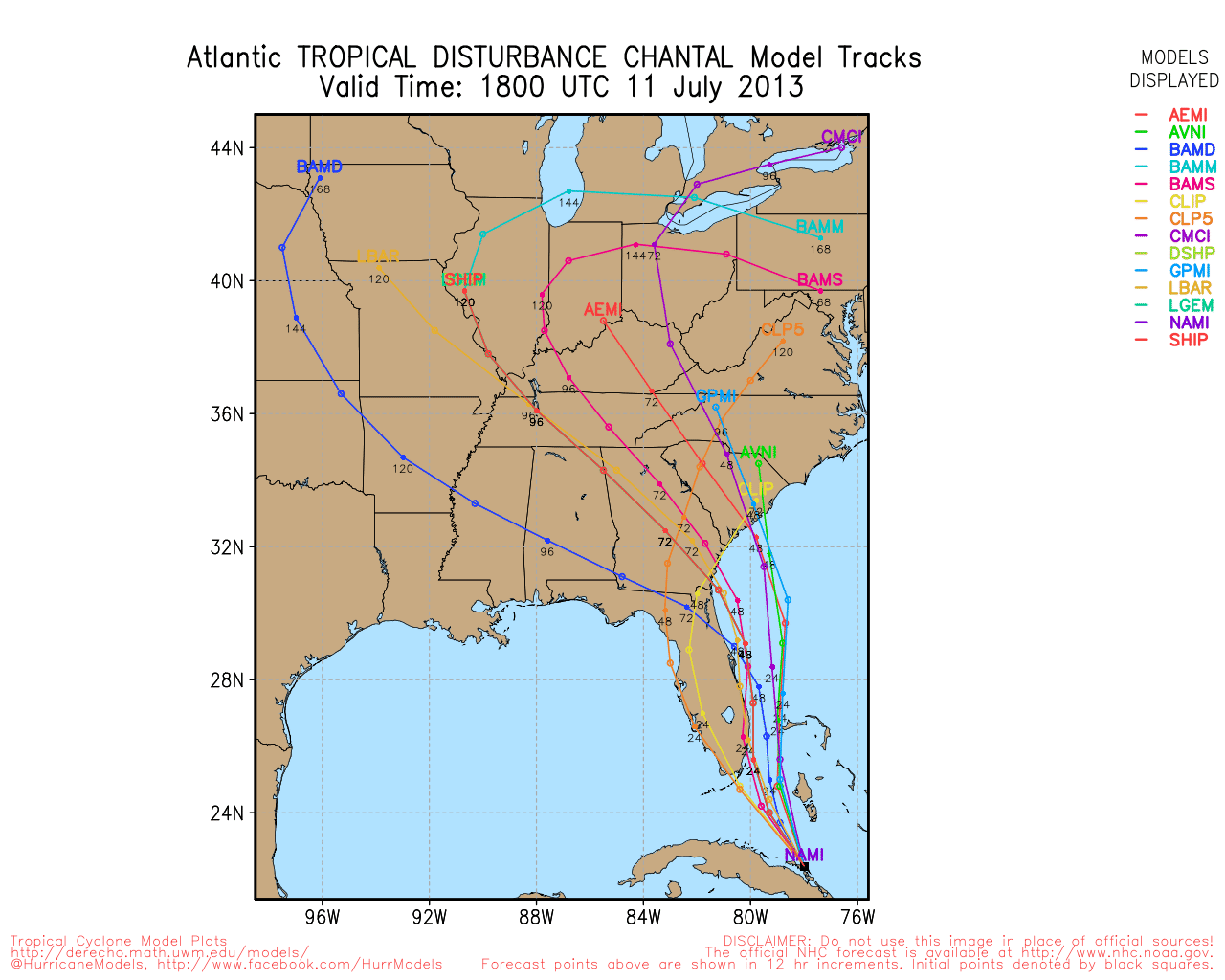
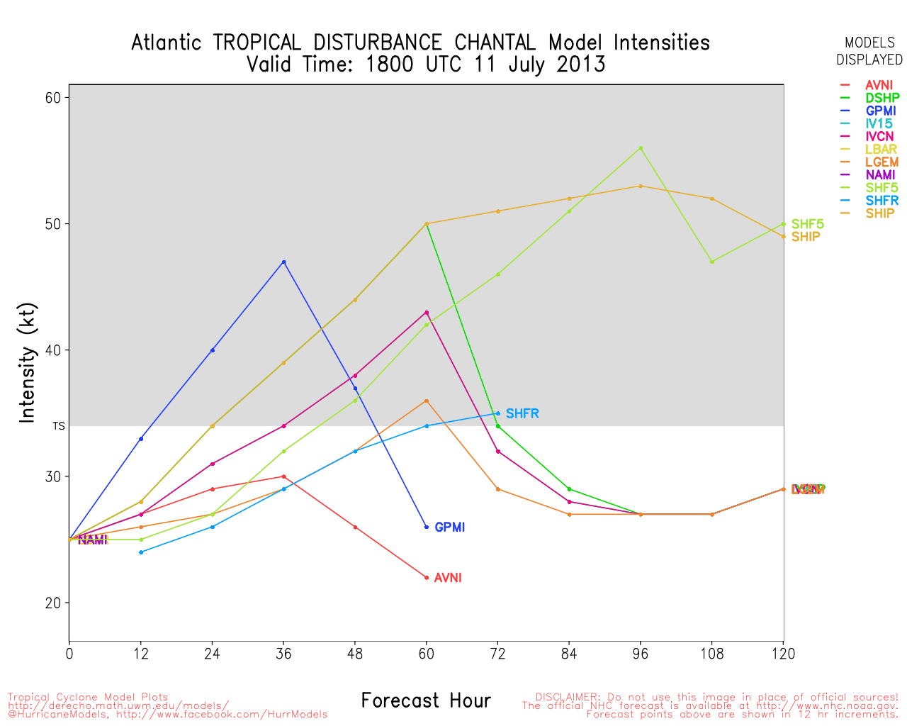
Model runs are starting to become interesting (see the Lounge), wanted to point out the cut off low in the Bahamas is starting to Flare up also, and may have to be watched in the short term.
Chantal's looking a bit worse this afternoon, mostly since the circulation center is a bit northwest of the convection.
|


 Threaded


