cieldumort
Moderator

Reged: Mon
Posts: 2305
Loc: Austin, Tx
|
|
7:30 PM EDT 31 July 2014 Update

SAL (Saharan Air Layer) has been blown and drawn into the very center of 93L's circulation today. This could easily be the kiss of death for just about most any other system, but it is these tenacious tropical lows that one should not write off so quickly, and as such, still gives 70% odds for development within the next 48 hours. After that, it is not entirely clear whether or not an upper-level low to 93L's northwest, which is currently in the process of retrograding and digging southwest, may do more to increase westerly shear while it is around the islands, or perhaps help induce and increase outflow.
Ciel
5:00 AM EDT 31 July 2014 Update
Despite being nearly decapitated by modest shear and some dry air entrainment, the low designated Invest 93L has continued walking a thin line from being upgradable, to being forgettable. Not surprisingly, yesterday adjusted their depression forecast to a coin flip: 50/50.
This morning 93L finds itself back in a slightly better environment to finally seal the deal, and has teams at the ready tentatively scheduled to check it out later today, or tonight.
Bottom line, more factors than not today support a potential resumption of development, and given 93L's still low latitude owing to its starts and fits, interests in the islands should take note. Near tropical storm force winds are already occurring, and only a small increase in organization could warrant watches and warnings, with a direct impact now more possible.
Ciel
9:15 PM EDT 28 July 2014 Update

While the last update from was merely an hour ago, giving 93L a 50% chance of development within the next 48 hours (and 70% within 5 days), the system has quickly become better organized throughout the late afternoon and evening, and now tonight it appears that a Tropical Depression could already be forming.
A very timely Scatterometer pass from about 7:42 PM EDT clearly shows that while still on the mild side, surface winds were closing off directly underneath a coalescing sphere of deep convection, a tell-tale sign of tropical cyclogenesis.
Ciel
Original Entry

After a fairly quiet couple of weeks in the Atlantic, things may be about to change.
The modest tropical wave that rolled off the coast of Africa a few days ago and that has been gradually picking up some steam has become sufficiently organized to be given an Invest tag for tracking: 93L.
As of 2AM EDT July 28, Invest 93L was located roughly 550 miles southwest of the Cape Verde Islands in the central Atlantic, moving west around 10-15MPH.
93L is in a favorable environment for further organization, and it looks probable that it will become a numbered tropical cyclone within the next few days, with movement expected to the west or west-northwest.
Ciel
StormCarib Reports from the Caribbean Islands
Caribbean Weather Observations
Barbados Brohav Weather Fax
Full Caribbean Radar Composite
Caribbean Broadcast Corporation (TV/Radio from Antilles)
San Juan, PR NWS Page
Various Caribbean Radio Stations
DR1 Dominican Republic Hurricanes
Bertha Event Related Links

SFWMD Model Plot (Animated Model Plot) SFWMD Hurricane Page
[https://flhurricane.com/floatanimator.php?year=2014&storm=3 Flhurricane Satellite Floater Animation of Bertha
GOES Floater
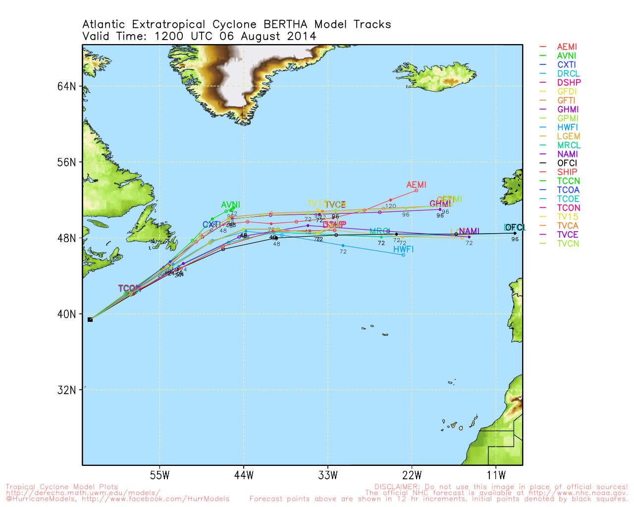
Animated Model Plot of Bertha
Clark Evans Track Model Plot of Bertha
(Animated!) Model Plots in Google Earth - In Google Maps
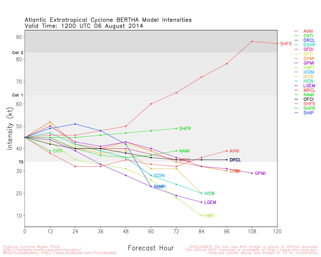
Clark Evans Intensity Model Plot of Bertha (Animated!)
Clark Evans Track Plot of Bertha
Other Model Charts from Clark
Clark Evans Top 10 Analog Storms for Bertha
More model runs on from RAL/Jonathan Vigh's page
NRL Info on Bertha -- RAMMB Info
COD Atlantic Satellite View
Edited by MikeC (Thu Jul 31 2014 11:20 PM)
|
danielw
Moderator

Reged: Wed
Posts: 3525
Loc: Hattiesburg,MS (31.3N 89.3W)
|
|
Current JSL and Funktop enhancements show very limited if any signs of Thunderstorms in or around 93L.
First visible satellite photo is half IR half VIS but is does show the system maintaining structure and low to mid level organization.
Moving westward at 10-15 knots. I question whether 93L is running on the periphery of the Total Precipitable Water envelope that it originated from. Seems to be lagging the pouch of the wave. Well behind the crest of the wave and near the trailing wave trough.
My perception at the current time.
Weak waves have been known to transverse the Lower Lesser Antilles mountains. Wait and see is the forecast now.
Edited by danielw (Wed Jul 30 2014 06:04 AM)
|
craigm
Storm Tracker

Reged: Wed
Posts: 327
Loc: Palm City, Florida
|
|
Lot of Dry air building in around 93L. Not sure if it can survive this environment.
http://midatlanticwx.com/hw3/hw3.php?con...e=wv&anim=2
--------------------
Why I'm here:
Weather hobbyist
|
danielw
Moderator
Reged: Wed
Posts: 3525
Loc: Hattiesburg,MS (31.3N 89.3W)
|
|
24 hours after my last post and 93L has regrouped with Thunderstorms in the Center and cirrus outflow 'fingers' scattered around the periphery of the system.
Southern half of the system has built up to the Mid levels, but the northern half is suffering through the SAL or dry air, or both.
This system still has a rather large envelope of tropical moisture and winds. Anything goes at this point.
Should the system maintain a static storm state today I would expect that Tropical Storm Watches COULD be issued for the Lower Lesser Antilles by Friday Morning. That's my two cents at this point and based on 93L maintaining or improving it's overall picture. No Pun intended.
JSL Enhancement showing location of thunderstorms.

Thin cirrus outflow fingers trying to establish position over the storm. Indicative of very light upper level winds and very little horizontal wind shear.

|
cieldumort
Moderator
Reged: Mon
Posts: 2305
Loc: Austin, Tx
|
|
Recon is now entering 93L from the northwest just in time to find the system undergoing another serious round of northerly shear and dry air entrainment.
As of 1:15PM EDT, the entire circulation is now exposed, with barely one or two showers hanging on to the south of the LLC. While the air to the north, northwest, and northeast of the well-defined circulation is not the very driest ever, there is just so much of it, that 93L's repeated attempts to become viable are being repeatedly blown away.
With odds of development back up to 70% as of 8AM EDT, this may be one of the trickiest Invests we have seen in some time. The degree to which "could be" and "should be" systems have already been struggling with the abundance of dry air and shear this year harkens back to 2006, which ended up busting seasonal forecasts well to the downside. For seasonal forecasts in 2014, most are already on the low side.
Some Pros & Cons for 93L's 48-hour development chances:
Pro: Well defined surface circulation
Pro: Pockets of winds already near or at Tropical Storm force
Pro: Persistence
Pro: Positive Pulse
Pro: Gradually increasing SSTs going forward
Pro: Some decrease in shear already underway, albeit unevenly
Con: Shear is still moderate, overall
Con: Well above average levels of dry air remain throughout the basin
Con: "Graveyard" ahead.
|
cieldumort
Moderator
Reged: Mon
Posts: 2305
Loc: Austin, Tx
|
|
Vortex message from Recon a little while ago confirms a closed surface circulation with maximum winds of about 40-45 MPH. If 93L doesn't open up into nothing more than a vigorous wave, which it may very well end up doing if convection doesn't begin building back up, and soon, then odds favor Tropical Storm Bertha being declared prior to its passage through or by the Antilles.
Some of the key stats from the Vortex
Time of Center Fix: 31st day of the month at 19:59:50Z
Center Fix Location: 417 miles (671 km) to the ESE (103°) from Bridgetown, Barbados
Maximum Surface Wind: 40kts (~ 46.0mph)
Minimum Sea Level Pressure: 1007mb (29.74 inHg) - Extrapolated
Maximum Flight Level Temp Outside Eye: 23°C (73°F)
Maximum Flight Level Temp Inside Eye: 25°C (77°F)
In addition to the WC-130 which penetrated the center multiple times, the Gulfstream (G-IV) has been sampling the air all around 93L today. Combined, the data from both of these missions will be fed into the models and coming runs should be much better for it.
|
danielw
Moderator
Reged: Wed
Posts: 3525
Loc: Hattiesburg,MS (31.3N 89.3W)
|
|
93L Pros and Cons... great idea.
We are now in Dmin (diurnal minimum with respect to storm strength and development) and 93L is barely definable on water vapor loops.
Although Recon sampled Tropical Storm force winds earlier it is hard to tell where those winds might be right now.
Another overnight wait to see what "wannabe Bertha 93L" does tonight.
Edit: Update- I checked the airport observations in the Lesser Antilles and almost all of the stations are reporting clouds below 2000 feet and light winds below 10 knots. All current barometric pressure reports are above 1014mb or roughly 29.95 inches. Normal
93L is now Tropical Storm Bertha. See the new thread.
Edited by danielw (Thu Jul 31 2014 11:19 PM)
|


 Threaded


