2:00 AM EDT Mon Jul 17 2017 Update
The Atlantic now has two disturbances being highlighted in the Tropical Weather Update. While not stated explicitly, it is possible that Potential Tropical Cyclone advisories may be issued later today on Invest 95L, and persons with interests in the Lesser Antilles may want to begin preparing for the possibility of heavy weather.
-Ciel

1:00 PM EDT Sun Jul 16 2017 Update
The area of low pressure that is roughly 950 miles east-southeast of the Windward Islands is now being tracked as Invest 95L. This disturbance has become slightly more organized today, and conditions appear favorable for continued slow development, and a tropical cyclone could form prior to the Low reaching the Lesser Antilles. Recon has been tentatively tasked to fly into this disturbance tomorrow, if necessary.
-Ciel
11:00 PM EDT Sat Jul 15 2017 Update
A trough of low pressure in the central Atlantic is being monitored for signs of organization. Conditions for TC genesis are only marginally favorable, but some slow development is possible while the area of disturbed weather tracks west, and conditions could become a little more favorable next week.
Elsewhere, the residual moisture and troffiness of former TD4 are now entering the northwesternmost portions of the Gulf of Mexico, adding to showers and thunderstorms in Louisiana and Texas. Redevelopment odds are close to zero.
-Ciel
9:30PM EDT 2 July 2017 Update
The wave in the far east Atlantic is now being tracked as Invest 94L, there's a lot of time to watch this one as it won't near the Caribbean until next weekend, and if it comes closer won't be near here until 10-15 days away. Right now it's too soon to tell.

Original Update
After a busy mid June, the end of June was very quiet in the Atlantic basin, the first few days of July are also quiet, but there are signs that may change later in the coming week.
July typically is a transition month, many times after early activity July winds up being fairly quiet. We start looking a bit further east for development, especially toward August, but a few things still tend to pop up from time to time.
There is a currently low chance wave in the far Eastern Atlantic that may develop mid next week, right now only a 20% chance. The setup for this area is such that even if it does develop, it may not directly affect any land areas. But it is something to watch. Speculation and model discussion can be found in the Forecast Lounge for the system.
Beyond that, typical areas to watch during July are the Gulf, western Caribbean, and along the Bahamas/East coast. None of which have anything in the shot term.
Invest 95L Event Related Links

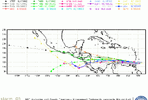
SFWMD Model Plot (Animated Model Plot) SFWMD Hurricane Page
[https://flhurricane.com/floatanimator.php?year=2017&storm=5 Flhurricane Satellite Floater Animation of 95
GOES Floater
Animated Model Plot of 95
Clark Evans Track Model Plot of 95
(Animated!) Model Plots in Google Earth - In Google Maps
Clark Evans Intensity Model Plot of 95 (Animated!)
Clark Evans Track Plot of 95
Other Model Charts from Clark
Clark Evans Top 10 Analog Storms for 95
More model runs on from RAL/Jonathan Vigh's page
NRL Info on 95 -- RAMMB Info
COD Atlantic Satellite View
Tropical Depression Four Event Related Links

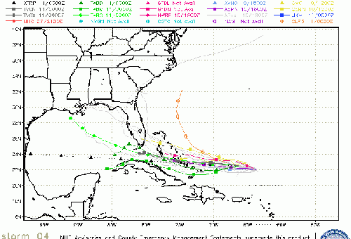
SFWMD Model Plot (Animated Model Plot) SFWMD Hurricane Page
[https://flhurricane.com/floatanimator.php?year=2017&storm=4 Flhurricane Satellite Floater Animation of TD#4
GOES Floater
Animated Model Plot of TD#4
Clark Evans Track Model Plot of TD#4
(Animated!) Model Plots in Google Earth - In Google Maps
Clark Evans Intensity Model Plot of TD#4 (Animated!)
Clark Evans Track Plot of TD#4
Other Model Charts from Clark
Clark Evans Top 10 Analog Storms for TD#4
More model runs on from RAL/Jonathan Vigh's page
NRL Info on TD#4 -- RAMMB Info
COD Atlantic Satellite View
StormCarib Reports from the Caribbean Islands
Caribbean Weather Observations
Barbados Brohav Weather Fax
Full Caribbean Radar Composite
Caribbean Broadcast Corporation (TV/Radio from Antilles)
San Juan, PR NWS Page
Various Caribbean Radio Stations
DR1 Dominican Republic Hurricanes
Edited by cieldumort (Mon Jul 17 2017 02:40 AM)


 Threaded


