4:00PM CDT 06 October 2020 Update
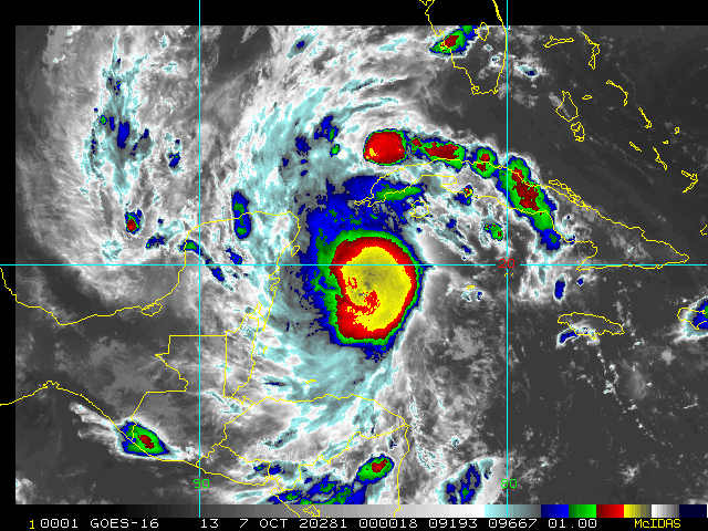
Hurricane Delta is a Category 4 hurricane with 145mph winds in the Northwest Caribbean, expected to landfall in the Northeastern Yucatan (Cozumel and Cancun area) tomorrow morning.
In the Yucatan, the life-threatening storm surge will raise water levels in areas of onshore winds by as much as 9 to 13 ft above normal tide levels along the northern coast of the Yucatan Peninsula from Cabo Catoche to Progresso, and 6 to 9 ft above normal tide levels along the eastern coast of the Yucatan Peninsula from Tulum to Cabo Catoche. Near the coast, the surge will be accompanied by large and destructive waves.
Beyond the impacts of the Yucatan it will have time to strengthen, but as it moves further into the Gulf increasing southwesterly shear and the cooler shelf waters over the northern Gulf are expected to cause some reduction in wind speed as it gets closer to land, but a significant increase in the size of Delta's wind field while it is over the Gulf of Mexico, which increases the spatial extent of the storm surge and wind threats for the northern Gulf coast. So regardless of Delta's final landfall intensity, the projected large size of the hurricane is likely to result in a very significant storm surge and wind event for portions of the northern Gulf coast later this week. Likely moreso than Sally or Laura.
Those in the areas please listen to local media and officials.
6:40PM CDT 05 October 2020 Update
Recon has found a closed eye. Pressure is down to at least 983mb, and it is just a matter of time before winds catch up to the pressure and structure. As we head into the overnight hours, it is becoming possible that Delta could bomb and become a very dangerous and formidable Major hurricane even sooner rather than later.
Model discussion is now open in the Delta Forecast Lounge .
-Ciel
5:40PM CDT 05 October 2020 Update
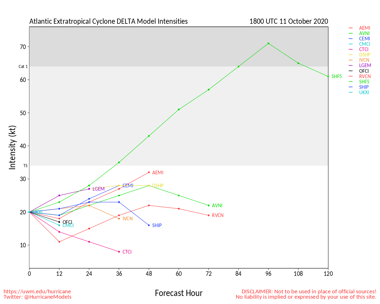
Delta continues to rapidly strengthen. The forecast calling for Delta to become a Major once in the GOM may actually be behind the curve, as the forecast has been to this point.
This cyclone is in a very favorable environment for Rapid Intensification over the next day or two at least and as Gamma has continued to weaken, likely helping alter conditions in the Gulf, it remains to be seen what could detrimentally impact Delta prior to landfall in the southern US (location still uncertain, but models are generally focused on Louisiana to W Florida panhandle.
Interests in the Northwestern Caribbean and Gulf of Mexico may want to begin preparing for the impact of what could become a fairly stout Major Hurricane.
-Ciel
3:00AM CDT 03 October 2020 Update
Gamma is intensifying tonight, with a recent blowup of very deep convection within the center of circulation. Recon is finding continual pressure drops, and winds are rising. In addition to being a substantial rain and flood threat for locations in the northwest Caribbean, Gamma very well may be making a mad dash to exceed wind and wave intensity forecasts.
Elsewhere, the wave behind Gamma may loop around it next week and could enter the Gulf. Behind that, even yet another approaching wave is up to bat, and is already looking active. Both of these are not yet Invest tagged, but could be over the weekend.
-Ciel
Original Entry
Two areas are being watched for early October, Invest 91L in the West Caribbean with a 70% chance to develop and another area east of the leeward islands with a 20% chance to develop over the next 5 days.
The impacts beyond the short term are unclear for both, but likely should be watched by the Yucatan, Gulf, and Caribbean islands.
Delta Event Related Links
SFWMD Model Plot (Animated Model Plot) SFWMD Hurricane Page
[https://flhurricane.com/floatanimator.php?year=2020&storm=26 Flhurricane Satellite Floater Animation of Delta
GOES Floater
Animated Model Plot of Delta
Clark Evans Track Model Plot of Delta
(Animated!) Model Plots in Google Earth - In Google Maps
Clark Evans Intensity Model Plot of Delta (Animated!)
Clark Evans Track Plot of Delta
Other Model Charts from Clark
Clark Evans Top 10 Analog Storms for Delta
More model runs on from RAL/Jonathan Vigh's page
NRL Info on Delta -- RAMMB Info
COD Atlantic Satellite View
Delta Forecast Lounge
Cancun Webcam
North Gulf Links
North Gulf/Southern Mississippi Valley Composite Radar Loop
(Latest Static)
East to West:
Mobile, AL Radar Radar Loop
(Latest Static)
New Orleans, LA Radar Radar Loop
(Latest Static)
Lake Charles, LA Radar Radar Loop
(Latest Static)
Houston/Galveston, TX Radar Radar Loop
(Latest Static)
Gulf of Mexico Satellite Imagery
Area Forecast Discussions:
Mississippi/Alabama/Pensacola -
New Orleans, LA -
Lake Charles, LA -
Houston/Galveston, TX
Mississippi/Alabama Gulf Coast Media/Links
WLOX TV 13 (ABC) Biloxi
WXXV TV 25 (Fox)Biloxi
WKRG TV 5 (CBS) Mobile
WPMI TV 15 (NBC) Mobile
WALA TV 10 (Fox) Mobile
WEAR TV 3 (ABC) Pensacola, FL
Newspapers
Mobile Register (Al.com) paper
Biloxi Sun Herald paper
Gulf Live
Radio (some)
News Talk 104.9 Biloxi, MS (Radio)
News talk 106.5 Mobile, AL (Radio)
Power Outage
Louisiana power outage map
Mississippi Power Outage Map
Alabama Power Outage Map
>
- Lake Charles, LA Area Media and Information
kplctv 7 NBC Lake Charles
Fox 29 Lake Charles
American Press Newspaper Lake Charles
Louisiana Information
Govt/Official Info:
Louisiana Emergency Management
Mississippi Emergency Management
Alabama Emergency Management
Louisiana Dept. of Transportation - Road Closures, Traffic Cams, etc.
Mississippi - Road Closures, Traffic Cams, etc
Alabama Road Conditions and Traffic Cameras
Media Newspapers/TV/Radio:
Nola.com New Orleans Times-Picayune
WWL TV 4 (CBS Affiliate in New Orleans)
ABC 26 TV (ABC Affiliate in New Orleans)
WDSU Channel 6 (NBC Affiliate New Orleans)
Fox 8 (New Orleans)
WTIX 690 News Radio
WWL 870 News Radio
WTOK 11 / Missippii Alabama ABC Affiliate
WKRG 5 in Mobile/Pensacola
WPMI Channel 15 from Mobile


 Threaded


