CFHC

Reged: Sun
Posts: 148
Loc: East Central Florida
|
|
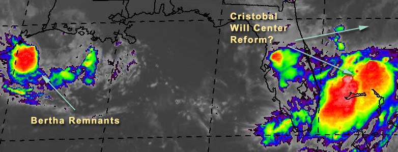
Tropical Storm Cristobal is being naughty. The models are telling it to go east, but instead it moves south.
What's really going on is the trough/front going through Georgia was supposed to kick it eastward, but instead it creeped south. The "center" is northeast of where you see all the rain and clouds. Which brings up the possibility where the center just may reform closer to Florida and miss the eastward jog altogether, leaving it to taunt us and the Bahamas for days on end. The upper level conditions aren't that great for strengthening now, but if it hangs around it could build up, just a stones throw away from us.
The rain in Central Florida was caused by the front coming down and enhanced by Cristobal, so we've already seen some of it here. It's important to watch Cristobal until it has decided to move east away from us.
Bertha Remnants are in the Gulf now, but rather disorganized. It won't have much time to reform--so other than a lot of rain, I don't see much from it.
Ed Dunham is making posts in our Storm Forum with some updates, and Snonut is back making some sporadic updates as well.
Dr William Gray and Company have put up the august updates of storm activity and have dropped it to 9 named stormss, 4 hurricanes, and 1 intense hurricane. I suspect this may be a tad too conservative, but not far off the mark.
NASA GHCC Interactive Satellite images at:
North Atlantic Visible (Daytime Only), Infrared, Water Vapor
Some forecast models:
NGM, AVN, MRF, ETA ECMWF
DoD Weather Models (NOGAPS, AVN, MRF)
AVN, , , , , UKMET
Other commentary at Mike Anderson's East Coast Triopical Weather Center, Accuweather's Joe Bastardi, Hurricane City, Gary Gray's Millennium Weather, Barometer Bob's Hurricane Hollow, Snonut, Ed Dunham in our Storm Forum Even more on the links page.
- [mike@flhurricane.com]
|
Steve
Senior Storm Chaser

Reged: Wed
Posts: 1063
Loc: Metairie, LA
|
|
Christobal is an interesting study. As we've been noticing this year, almost everything splits. The LLC is heading on out with the trof, but the convection continues to slip slowly southward. Will this energy pulse down into nothing or will it provide the energy for the next storm? They'll still call it Christobal but it will be another entity altogether. Watch the high behind the trof and what it does because this is another situation where the pattern can influence the weather immediately to the south of the high pressure. Most of the 00 model runs keep a piece of energy south while sending TS Christobal out to sea. They're not doing anything with the energy which shows up as a curve or bend in the pressure gradients.
Dr. Gray's new numbers are out, and he has IMHO drastically reduced the hurricane threat for the 2002 season. I doubt the numbers will ultimatey be as low as what he has now forecasted - 9/4/1. Only 4 hurricanes in the entire season with this type of setup? I just don't see it. There are some inhibiting influences from the point of view that hurricanes form from tropical waves crossing the Atlantic Ocean, but not from the point of view of things that can spin up at the tail end of a front or just out of the pattern itself. In 2002, I've argued against Dr. Gary Gray so I might as well argue against Dr. BIll Gray. My prediction of 13/8/3 may ultimately be too high, but I think 9/4/1 is too low.
Steve
--------------------
MF'n Super Bowl Champions
|
Anonymous
Unregistered
|
|
Yeah, I believe Gray may be too low, and we may see more west Caribbean development. Cristobal is nearly stationary again, with the center getting elongated. If he can stay in there (that general vacinity) another 24 hours, we'll see a threat somewhere on Friday/Saturday. But he'll have to moisten up some. He's a contender cause he's putting up a good fight against one hell of a trough. Cheers!! Steve H.
|
Ed Dunham
Former Meteorologist & CFHC Forum Moderator (Ed Passed Away on May 14, 2017)
Reged: Sun
Posts: 2565
Loc: Melbourne, FL
|
|
Gee Steve (see June 9th post in the Storm Forum), I thought that the new numbers looked great! Just took the Doc a couple of months to catch up  (Sorry man - couldn't resist - I must be feeling better) (Sorry man - couldn't resist - I must be feeling better)
ED
|
StormHound
Weather Guru
Reged: Sun
Posts: 187
Loc: Orlando, FL
|
|
Looks like our friend Christobal is about to be kicked out to sea by the big bad ridge. The high is digging down into Florida and should be ready to spit out the annoying little storm we know as Chris.
--------------------
Storm Hound
Computer Geek
|
Rickoshade
Registered User
Reged: Wed
Posts: 8
Loc: Mobile Al
|
|
the season will be longer than current weather norms...partially because of methane hydrate delays. In an interesting study of their electical input to storms and the intensity and cause/effect relationship, a very astute professor has theorized that the hurricanes are as much an electrical phenomenon as they are warm water induced. All the factors can make for a severe storm. Briefly, he considers normal silt run-off from rivers into the main bodies of water as carriers of methane hydrates, which electrically charge and stimulate the formation and intensity. Because of the damming of the rivers on a global scale, and other factors, the season in his view is "delayed"......one of his proofs is hurricane Mitch, a few years ago...which formed over extensive methane hydrate fields...that typically strengthen in September, October, and even in November....this theory of his is NOT accepted, nor even studied in the "mainstream" scientific circles...but i found it fascinating....
I am quite the novice..but would love further input on this...suffice to say...we could have an extremely active season....despite what some "experts" think...
|
Anonymous
Unregistered
|
|
He caught up to you! Ha Ha. I see your back in the saddle again; were you sick?? Hope all is well. And yes I see the big bad trough as well...but Chris is hanging in....ast least for the moment. He is actually showing of signs that he might strengthen again, with convection building around the center. Seems to be dumb-belling around the center, whcih is N-S right now and really closer to 28.5 IMO. It ain't over til it's over. Hey Ed, you think this season will conclude early? I seem to remember you saying something like that. Have we had all the excitement we're going to see this year? That would be dull. I still think we'll see at least 11 named storms this year. Cheers!!
|
Anonymous-doug
Unregistered
|
|
I think all the mystery about relocation is over...the latest visible shows a definite move of the LLC east and some rather impressive convection NE and S of the center...still some shear N to S, but the new convection is the first I've seen contiguous with the LLC and that is more healthy for the system...if that continues that will pull all the rest of the energy lingering around it, into it and out to the east with it...bye bye Cris! EDS.
|
Keith L
Unregistered
|
|
Cristobal is taking off like a rocket after looking at the latest IR loop. However he is leaving behind some of his baggage which continues to move South or South South West. Could this be what we will be watching this weekend? If you look at Bastardi's comments yesterday he alluded to this
|
jth
Storm Tracker
Reged: Mon
Posts: 275
|
|
I still don't see this movement. It appears that there are just some storms firing on the northeast side. Actually, I think the center is closer to the tiny little blob that has formed very recently on what looks to be the SW side.
|
Anonymous
Unregistered
|
|
No really I think your on it. Good to see you back! I think we will see no less than 11 named systems this year despite what the good Doc says. Steve is a dull boy without some excitement during this no football time of year. So ya think we're done with the excitement for the year Ed?? How do you see the rest of the year based on the update from Gray? Cheers!!
|
Hurric
Weather Guru

Reged: Thu
Posts: 116
Loc: Port St. Lucie, Fl
|
|
Looking, and don't see either a center relocation or a fast movement off towards the east. Looks like maybe some buildup on the NE side of the center. Maybe I am just not picking up on the changes.
Here is a link to one of the loops I used.
http://flhurricane.com/cyclone/newreply.php?Cat=&Board=tb2002&Number=1763&page=&view=&what=showflat&sb=&o=&fpart=1&vc=1
If you have a better or more recent link please post.
Thanks
Hurric
|
Anonymous
Unregistered
|
|
Sorry for the double post before, but Ididn't see it show up after entering it. He hasn't moved much at all, and I agree jth, the convection is firing NE and just south of the center, which is aligned N-S. I believe he got pushed to the south a tad by the NE flow he's encountering. We'll see if he can dig in to survive the blast that's coming later today from the trough. cheer!! Steve H.
|
Anonymous-doug
Unregistered
|
|
The WV imagery suggests that the LLC is absorbing into the trough that is rapidly digging NE-SW toward and over the peninsula...the moisture moving over the state of FL now is in advance of that trough...I would guess an upper low is forming in the eastern GOM abreast of Naples...in any event CRis is not purely tropical now as it is over ridden with very dry air aloft.... EDS>
|
Anonymous
Unregistered
|
|
Navy has put back on their site. Thuderstorms building around the center.
|
ShawnS
Storm Tracker
Reged: Fri
Posts: 226
Loc: Pearland,Tx
|
|
Bertha does not have enough time to do anything. She is barely out in the water and is moving straight west. She was suppose to move SW and that was going to be the only way that she would have had enough time to re-develop. She is a goner!
|
Anonymous
Unregistered
|
|
Shawn its moving SSW buddy. Storms building.
|
Kevin
Weather Master

Reged: Fri
Posts: 524
Loc: EC Florida
|
|
Bertha's return: This one's simple. The low with Bertha has moved back out over water and a ring of intense convection has developed near the center. By tommorrow morning the system should be fairly easy to define as a tropical low, followed by re-development later tommorrow. This one could hit south TX or north Mexico as a moderate category 1 as I see it at this point. It is currently heading southwesterly. Heads up to everyone along the western Gulf, Bertha's coming back for seconds.
Christobal: His tracking has been just as weird as his name. It does appear the main area of low pressure will be taken northeast by the trough but there is an area of energy over south Florida that could be left behind. I've have to think that this piece of energy could develop eventually (in Carribbean or GOMEX). The weather has been tropical here in central Florida: sunny, rain and wind, sunny, rain and wind, and you get the point. It was also storming around 5 AM here this morning, a rare thing inland. You know something's different when that happens.
Gray's forecast: Three words. BASTARDI IS SUPERIOR. For this year, anyway. Just look at his record: he's pegged nearly all of the systems that have formed this year ahead of time. He really seems to have a good feel for the pattern this year, something he's lacked in recent years. Only 4 hurricanes and 1 major? No way. My forecast of 11/6/2-3 should prove superior to Gray's as will Bastardi's. It should also be noted that many of his new analogs HAVE MAJOR SOUTH FLORIDA HITS. Betsy and Andrew are among them. It's almost like bits of his forecast contradict what he's saying. As for El Nino: Moderate? Maybe when hell freezes over. This El Nono is an afterthought at best.
I'm glad to say my first few days of high school have gone well!
The tropics are getting interesting and I'm loving it. 
|
Anonymous
Unregistered
|
|
Bertha's Back! Why so pessimistic Shawn...you're usually looking for storms headed to Texas.
|
Anonymous
Unregistered
|
|
Shore can't agree more with your post...can I add one small observation? I was watching the visible loop on Bertha...she is heading more south than east...and appears to have ample time to "beef" up...very fascinating...and in fact...were she to stall....or stay out long enough....seems quite possible she could be a looper....you know.....oscillate and head back northerly in who knows what direction.
wouldn't suprise me if she suprises us all!
|


 Threaded


