Anonymous
Unregistered
|
|
That low in the gulf is banding. If it gains convection it may pop. any thoughts anyone?
|
Rich B
British Meteorologist
Reged:
Posts: 498
Loc: Gloucestershire, England, UK
|
|
Kinda reminds me of that tiny, convection free, Tropical Depression Four of August 2000!
--------------------
Rich B
SkyWarn UK
|
Anonymous-troy
Unregistered
|
|
rich ya mean the one off yhe FL coast that year
btw dolly is lookin nice...
|
Anonymous
Unregistered
|
|
Typical of this yr, here is this huge convective complex just east of the islands...probably just due to divergence,,,but they could at least mention it and clarify, right?
IHS,
Bill
|
Anonymous
Unregistered
|
|
All you got to do is look at the IR this am....here comes a real capeverder.
IHS,
Bill
|
Colleen A.
Moderator

Reged:
Posts: 1432
Loc: Florida
|
|
"That low in the gulf is banding. If it gains convection it may pop. any thoughts anyone?"
Just one: oh crap.
--------------------
You know you're a hurricane freak when you wake up in the morning and hit "REFRESH" on CFHC instead of the Snooze Button.
|
Anonymous
Unregistered
|
|
elaborate colleen.
|
Anonymous
Unregistered
|
|
they have a plane scheduled for 1800z tommorow

|
Anonymous-doug
Unregistered
|
|
Just a few comments on all the non Dolly activity...points of interest this am were: NE of Puerto Rico- latest Sat,=. pics. suggest the shear machine is winning that battle right now as it moves west.
East of Bahamas: a Bastardi point of interest...this still moving generally west , but dropping its convection along the way, new convection growing arond the circulation now, last nights convection still in place where it was...slow development potential, if any.
GOM: a vigorous upper trough is easily seen on water vapor pics. Nothing there now as far as surface features go.
SW Carribean: the LLC of that is now over land as it moves generally west.
Dolly: Looking like a classic Cape Verde Storm
EDS.
|
Anonymous
Unregistered
|
|
Classic Cape Verde. Classic.
And, wouldn't be surprised despite the problems down the road with shear that this lady doesn't become an Intense Classic Cape Verde.. this is no understudy waiting in the wings, she is begging to go center stage.
Unreal beautiful. Can't look at her pulling herself together and not think back over so many Cape Verde storms of the past.
Enjoy her now.. cause she's going to break a few hearts a long the way.
|
Anonymous (HF)
Unregistered
|
|
an amplification out in the central atlantic is going to erode the subtropical ridge early next week. basically dolly has to stay down and not move wnw for the meanwhile, as amplifications out there tend to get most early developing cape verdes. speaking of which, dont think dolly is quite as strong as 55kt. 45 maybe.
second area on my list is the one near 25/70. persistence and the environment ahead, and the fact that it has been trying to develop down to the SFC. if it pops, the east coast gets hit. it has, by the way, been slowing down.
third in terms of imminent interest is the gulf low. dont follow the take that it's like TD4 from aug 2000. that was a tight, semiconvective swirl, this one is quite broad. globals have been predicting this for days, now here it is. probably wont do anything until the chaser wave catches up and spikes the convection. movement unsure, mostly west by models, but could be sw or nw. steering env isnt very strong.
sw caribbean--good looking invest yesterday went without convection for too long. the broad SFC low still seems to be there, but mid level stuff is gone. not going to do anything in this basin unless convection comes back. what hernan in the eastpac does should tell what former 93L will.
wave near the islands.. have to mention it. because bastardi did. env ahead isnt half bad, so once it gets by the shear.. well, have to see what it can do. energy from it could easily catch up to the disturbance at 25/70 and spark it.
nw atlantic: keeps trying to develop a westward moving storm near bermuda... from the upper low working down? strictly , but there is forecast to be an amplification in the area, so SFC prog might check out.
HF TLH, FL 1632z30august
|
Anonymous-doug
Unregistered
|
|
Greatest threat over the next 5 days or so could be in our immediate area, IMO...IF the global forcasts the is wanting to put its stock in are correct. In that case a vigorous mid-atlantic trough which could pick up Dolly...would also of necessity cause a ridge to develop to its west closer to the islands and Carribean...things are too unsetteled in those areas for something not to occur, IMO...So don't be surprised if something does pop up west of 75w in the next 4-5 days...This is just a purely personal and totally amatuerish opinion, but I'm looking toward that as a serious possibility.
See you all next week. EDS.
|
Colleen A.
Moderator

Reged:
Posts: 1432
Loc: Florida
|
|
I did elaborate. 
I just read the Recon Flight Plan, and unless they've changed it, and it wasn't updated, they are going in today: Here are the coordinates for today's flights: 12.5N/80.0W
Tomorrow's coordinates are: 13.0N/82.0W
Also...I just looked at 12:00UTC loop from the Eastern Atlantic, and unless I am not looking at where the center is, it appears that it may have jogged just a bit to the north. Can anyone else see that? I looked at the last 3 coordinates for Dolly: 9.7N/33.7W
9.8N/34.9W
10.4N/37.2W
Seems that between the 2nd and 3rd coordinates, it sure has moved alot. I know it has a high forward motion, but could it have deviated that much in the last 6 hours? Just curious.

--------------------
You know you're a hurricane freak when you wake up in the morning and hit "REFRESH" on CFHC instead of the Snooze Button.
|
Anonymous
Unregistered
|
|
802
NOUS42 KNHC 301600
WEATHER RECONNAISSANCE FLIGHTS
CARCAH, National Hurricane Center, MIAMI,FL.
1200 PM EDT FRI 30 AUG 2002
SUBJECT: THE TROPICAL CYCLONE PLAN OF THE DAY (TCPOD)
VALID 31/1100Z AUG TO 01/1100Z SEP 2002
TCPOD NUMBER.....02-100
I. ATLANTIC REQUIREMENTS
1. SUSPECT AREA (GULF OF MEXICO)
FLIGHT ONE
A. 31/1800Z
B. AFXXX 01DDA INVEST
C. 31/1600Z
D. 27.0N 92.5W
E. 31/1600Z TO 31/2330Z
F. SFC TO 10000 FT
|
Anonymous (HF)
Unregistered
|
|
dolly's convection has really died off today. still going, but not like before. estimates 2.0/3.0 now. this die off is probably a subsidence related. follows that i dont expect dolly to intensify very rapidly next few days, track mostly to the west.
GOM system is drifting west by visibles.. the true story is told on WV. big stream of subsidence from the north, northerly shear, ripping away the convection. upper high over texas lies ahead though, so the unfavorable environment shouldnt persist.
WV tells a complicated story with the system near 25/70. system is sandwiched between upper lows, diffluence aiding the convection, very complicated. if it can get a surface connection going, its a no-brainer, but that still hasnt really happened like it needs to.
SW carib system seems to have transferred most of its energy to the eastpac, will probably develop over there.
by the way, another fairly good wave coming down the pipeline. has a similar signature/profile to dolly's while still over land. maybe an invest in 2-3 days if it can hold together.
HF 1838z30august
|
Anonymous
Unregistered
|
|
Well, I said yesterday I thought I saw a gulf low and I did:)!
Intersting that TPC has a recon going out there, nothing is there now, they are usually stingy with Recon resources. Hmmm.
IHS,
Bill
|
Anonymous
Unregistered
|
|
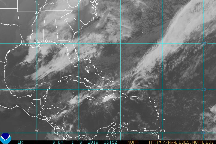
Latest IR image:

|
SirCane
Storm Tracker

Reged:
Posts: 249
Loc: Pensacola, FL
|
|
I couldn't believe back in 2000 that TD 4 was classified as a TD. It didn't have any convection or storm activity.
Doesn't mean there won't be any in the future.
I think Dolly will be a Hurricane by tomorrow, making her the first Hurricane of the season just before Septemeber rolls around.
SirCane
--------------------
Direct Hits:
Hurricane Erin (1995) 100 mph
Hurricane Opal (1995) 115 mph
Hurricane Ivan (2004) 130 mph
Hurricane Dennis (2005) 120 mph
http://www.hardcoreweather.com
|
Anonymous
Unregistered
|
|
Maybe Ms. Dolly should be renamed Ms. Dynagel 
|
Colleen A.
Moderator

Reged:
Posts: 1432
Loc: Florida
|
|
To Anonymous: Please see the line (#1) where it says "SUSPECT AREA". This flight is for the SW CARRIBBEAN, your post was for the GOM. Also, look at the DATES for which they are valid. They may cancel the one for the GOM tomorrow if it doesn't do anything, but as far as I can tell they have NOT cancelled the one posted below which is for a COMPLETELY DIFFERENT AREA.
000
NOUS42 KNHC 291415
WEATHER RECONNAISSANCE FLIGHTS
CARCAH, National Hurricane Center, MIAMI,FL.
1015 AM EDT THU 29 AUG 2002
SUBJECT: THE TROPICAL CYCLONE PLAN OF THE DAY (TCPOD)
VALID 30/1100Z AUG TO 31/1100Z AUG 2002
TCPOD NUMBER.....02-099
I. ATLANTIC REQUIREMENTS
1. SUSPECT AREA (WESTERN CARIBBEAN)
FLIGHT ONE FLIGHT
A. 30/1700Z A. 31/0600Z
B. AFXXX 01DDA INVEST B. AFXXX 02DDA CYCLONE
C. 30/1200Z C. 31/0000Z
D. 12.5N 80.0W D. 13.0N 82.0W
E. 30/1600Z TO 30/2100Z E. 31/0400Z TO 31/1000Z
F. SFC TO 10,000 FT F. SFC TO 10,000 FT
2. OUTLOOK FOR SUCCEEDING DAY CONTINUE 12 HRLY FIXES
--------------------
You know you're a hurricane freak when you wake up in the morning and hit "REFRESH" on CFHC instead of the Snooze Button.
|


 Threaded


