CFHC

Reged: Sun
Posts: 148
Loc: East Central Florida
|
|
Update at 5PM:
May have jumped the gun on the TD5 rumor. In any case, we could be looking at a TD later tonight or tomorrow.
Update at 4PM:
94L will be becoming Tropical Depression #5 at 5pm. More coming soon....
Original Update:
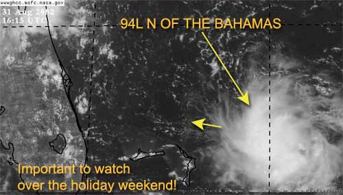
It is Labor Day weekend and the tropics are firing up.
The system (94L) just east-northeast of the northern Bahamas is looking more interesting by the hour. Since this system is so close the east coast of Florida it needs to be watched by all interests along our coast. This system very likely could be Tropical Depression #5 by the end of today.
There is a possibility that it could just die out (although I doubt it). The National Hurricane Center is sending recon out this afternoon to check it out.
In any case, it could bring a lot of rain to Florida for Labor Day. We are definitely keeping a close eye on this one.
Dolly seems to be holding its own at this time (barely) and it continues on its west northwest track. It has the potential of encountering some more heavy shear in the future and may dip below Tropical storm Strength for a while. However, I don't see it dissapating.
NRL Monterey Marine Meteorology Division Forecast Track of Active Systems (Good Forecast Track Graphic and Satellite Photos)
NASA GHCC Interactive Satellite images at:
North Atlantic Visible (Daytime Only), Infrared, Water Vapor
Some forecast models:
NGM, AVN, MRF, ETA ECMWF
DoD Weather Models (NOGAPS, AVN, MRF)
AVN, , , , , UKMET
Other commentary at Mike Anderson's East Coast Triopical Weather Center, Accuweather's Joe Bastardi, Hurricane City, Gary Gray's Millennium Weather, Barometer Bob's Hurricane Hollow, Snonut, Ed Dunham and Jason M in our Storm Forum Even more on the links page.
- [john@flhurricane.com]
Edited by MikeC (Sat Aug 31 2002 05:11 PM)
|
Anonymous
Unregistered
|
|
The system off the east coast of florida is looking very intresting and believe we will have TD#5 possibly before the day is over. Recon is investigating this system this afternoon. People living in florida will won't to keep a close eye on this system this holiday weekend.
|
Joe
Storm Tracker
Reged: Mon
Posts: 216
Loc: St.Petersburg,FL
|
|
Sorry last post was me.
|
garyb
Weather Guru
Reged: Wed
Posts: 106
Loc: Hernando Beach,Fl
|
|
http://www.nhc.noaa.gov/tafb/danger_atl_15.gif
|
Steve
Senior Storm Chaser

Reged: Wed
Posts: 1063
Loc: Metairie, LA
|
|
Real quick - someone help me on this. Why are my odd number news page views scrolling off my cpu screen, yet the even ones (2,4) are the normal width? I checked settings but didn't see a screen adjustment.
Thanks,
94L is it? Looks a little impressive. There's a lot of energy to the south as well. Wonder if something could cook tomorrow evening?
Steve
--------------------
MF'n Super Bowl Champions
|
ROB H
Weather Watcher

Reged: Wed
Posts: 32
Loc: Clearwater, FL.
|
|
Steve,
I am having the same problem
|
Anonymous
Unregistered
|
|
I think because of the size of the picture on the page, maybe?
|
Colleen A.
Moderator

Reged: Sat
Posts: 1432
Loc: Florida
|
|
Steve & Rob....it isn't just you guys...I am also having the same problem. Could be just a glitch in the system.
You know....that system in the Bahamas sure looks at lot bigger on the satellite photo posted here...
And to cut Steve Lyons a little break, he is only reporting what the is reporting. Which is that the system is moving WNW. They never really deviate from the official forecast, even if we can see it with our own eyes. Remember Irene? WE saw it moving towards S. Florida....the , however, kept insisting it was heading towards the South Central Gulf Coast, and Miami suffered greatly because they would not correct the position. I am sure that once the Recon plane gets in there, they will have a better fix on it. Floridians: HEADS UP!
--------------------
You know you're a hurricane freak when you wake up in the morning and hit "REFRESH" on CFHC instead of the Snooze Button.
|
Colleen A.
Moderator
Reged: Sat
Posts: 1432
Loc: Florida
|
|
No, it was doing it on the last news story also. I thought there was something wrong with my monitor..thank goodness there isn't. ;-)
--------------------
You know you're a hurricane freak when you wake up in the morning and hit "REFRESH" on CFHC instead of the Snooze Button.
|
MikeC
Admin
Reged: Sun
Posts: 4543
Loc: Orlando, FL
|
|
I made a few adjustments, let me know if that fixed anything for you.
Hmm. Being on the coast this weekend (New Smyrna), I'm definitely eyeballing the storm the entire weekend, and since I have company too. Joy 
|
ROB H
Weather Watcher
Reged: Wed
Posts: 32
Loc: Clearwater, FL.
|
|
Mike,
Thank you for the fix. It worked.
|
ROB H
Weather Watcher
Reged: Wed
Posts: 32
Loc: Clearwater, FL.
|
|
I read on another board that 2 recon plans are out at this
time. 1 in the gulf, 1 on its way to area east of fl.
|
Colleen A.
Moderator
Reged: Sat
Posts: 1432
Loc: Florida
|
|
Mike or John: is the message in red that is scrolling across the screen re: 94L your message or an official message?
Looking at the satellite pics, this system to be wrapping itself up quite nicely...unless the center is to the south of that convection.
I also do not see any WNW movement whether the center is below the convection or is in the middle of the convection. It appears that it is moving due west. Dr. Steve Lyons can only report on the information he is getting from the ....I don't believe he can/will deviate from the official forecasts. Wouldn't be prudent. 
I am very interested in finding out what Recon will report.
--------------------
You know you're a hurricane freak when you wake up in the morning and hit "REFRESH" on CFHC instead of the Snooze Button.
|
tony
Unregistered
|
|
Area Forecats Discussion from TLH/MLB state that Bahama system should approch the MLB area Sundy night/Monday and any tropical ways approaching Fl shoud move west across Fl into the GOM.
|
MikeC
Admin
Reged: Sun
Posts: 4543
Loc: Orlando, FL
|
|
Colleen, I changed it a bit to make it a little more obvious it came from us. I think its important over a holiday weekend to emphasize something like this even if it winds up missing or being minor. The mere fact that it reallty hasn't shown up on the radar until midday today (during the weekend) made me put that up. It's not an indication that anything will come of the system, but the fact many people are away for the weekend makes it more of an issue to get the word out to watch it.
|
MikeC
Admin
Reged: Sun
Posts: 4543
Loc: Orlando, FL
|
|
HHunters found 50knot winds in one of the thunderstorms and a pressure of 1008mb. The wind clock may just be a gust, but I'm thinking TD or TS very very soon.
Edouard....
|
Colleen A.
Moderator
Reged: Sat
Posts: 1432
Loc: Florida
|
|
Oh, ok Mike...no problem. I agree with you that it's important to make people aware of this system. Thanks for clarifying that, Mike. :-)
50 knts? Hmmm. We better keep our eyes peeled.
--------------------
You know you're a hurricane freak when you wake up in the morning and hit "REFRESH" on CFHC instead of the Snooze Button.
|
troy
Unregistered
|
|
Mike any info on direction?? it is small but has a nice shape.
troy
|
Jeanine
Weather Watcher

Reged: Mon
Posts: 36
Loc: Hollywood, FL
|
|
I just heard the same thing on 50kt winds probably just in a thunderstorm?  Also having the same problem with pages taking up the whole screen. WIll probably know more at 5:00pm. Heads up!!!! Also having the same problem with pages taking up the whole screen. WIll probably know more at 5:00pm. Heads up!!!!
|
troy
Unregistered
|
|
how do i find the "Area Forecats Discussion from TLH/MLB " that Tony mentioned? any one have the link?
thanks troy
ps mike how do i get my login info if I lost it? 
|


 Threaded


