CFHC

Reged: Sun
Posts: 148
Loc: East Central Florida
|
|
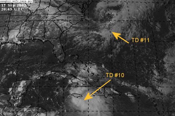
Tropical Depression #11 forms east of Bermuda and is heading to the North at 8mph. Most likely this system will not strengthen too much and become an fish spinner.
Tropical Depression #10 is a different story. Ten is keeping everyone on edge with its unknown path and strengthening potential. Ten is moving toward the west-northwest near 6mph and a motion to the west-northwest or northwest is expected during the next 24 hours. Also ten is expected to become a tropical storm within the next 24 hours
NRL Monterey Marine Meteorology Division Forecast Track of Active Systems (Good Forecast Track Graphic and Satellite Photos)
NASA GHCC Interactive Satellite images at:
North Atlantic Visible (Daytime Only), Infrared, Water Vapor
Some forecast models:
NGM, AVN, MRF, ETA ECMWF
DoD Weather Models (NOGAPS, AVN, MRF)
AVN, , , , , UKMET
Other commentary at Mike Anderson's East Coast Tropical Weather Center, Accuweather's Joe Bastardi, Hurricane City, Gary Gray's Millennium Weather, Barometer Bob's Hurricane Hollow, Snonut, Ed Dunham and Jason M in our Storm Forum Even more on the links page.
- [john@flhurricane.com]
Edited by MikeC (Tue Sep 17 2002 07:13 PM)
|
Anonymous
Unregistered
|
|
there is a power house front coming should be no no were to go but n/e south fl if that gulf coast have a nice weekend
|
HanKFranK
User

Reged: Mon
Posts: 1841
Loc: Graniteville, SC
|
|
hey anon. you havent got a clue. would take a pretty big amplification along the east coast to get this baby to recurve that sharply, and none of the globals have that. most have the storm trying to phase into the shortwave leading the next amplification, as does the official forecast. as a matter of fact, is playing outlier, it keeps the storm welll south of the amplification, right off NW cuba, builds the ridge back overhead, and turns it WSW into the bay of campeche. i find that more likely than your guess, which is better suited for late season systems.
anyway that run is the best support i can find for a further west system. if the trough forecast to draw what will be isidore up doesnt get the storm, then the mexico drive could be on to something.
but, most likely path right now is up into west central or northwestern florida, somewhere.
HF 2221z17september
|
Colleen A.
Moderator

Reged: Sat
Posts: 1432
Loc: Florida
|
|
Ok, I'm confused, HF. Are you saying that you think FL is a target or you think it will get pulled more west? I'm not being a smart alek, just tired today. Thanks... 
--------------------
You know you're a hurricane freak when you wake up in the morning and hit "REFRESH" on CFHC instead of the Snooze Button.
|
HanKFranK
User
Reged: Mon
Posts: 1841
Loc: Graniteville, SC
|
|
i'm saying it's more likely it will miss the trough entirely and turn west than for the trough to be deep enough to turn it sharply east and only affect south florida.
18z avns have a less dramatic version of 12Z, the system gets to NW cuba and just stalls there for a while, then starts moving wnw. considering avn has the system as a 1008mb low.. and is only somewhat deeper.. i wouldnt take them that seriously. when the storm is up there friday it will probably be lower than 970mb. the upper trough is more likely to recurve a strong system than a weak one.
HF 2256z17september
|
ShawnS
Storm Tracker
Reged: Fri
Posts: 226
Loc: Pearland,Tx
|
|
I still say west gulf or bust!
|
Anonymous
Unregistered
|
|
Wherever he goes, hes gonna be a monster. Did you get a load of the 22:40 IR?? holy cow batman!! Starting to wrap where the recon put it's last fix. Being that the shifted it's track to the right, and the intensity which is starting to occur, I buy the track for the time being. When cyclones develop strongly they want to go poleward unless there is a strong ridge to prevent that, like Mitch and Keith, that got caught under the heat ridge. I don't want to get hit by this one!! GOM you can take him, but you'll have to rebuild. Cheers!! Steve H.
|
Rad
Weather Guru

Reged: Thu
Posts: 173
Loc: St. Pete Fl. {27.8N 82.7W}
|
|
TOOO soon to call this one , MUST wait till Thursday , to have a better handle on this tropical entity.
--------------------
RIDE 2 LIVE 2 RIDE
|
clyde w.
Storm Tracker
Reged: Fri
Posts: 211
Loc: Orlando, FL
|
|
Latest recon put the center at 16.6N and 77.6W, right under the deep convection. The storm is getting better organized, but flight level winds were still only 38kts and pressure still 1006mb.
|
57497479
Weather Master

Reged: Sun
Posts: 414
Loc: W. Central Florida
|
|
I'm starting to become very concerned , we have talked for years now about a hurricane hitting central fl and now that it may really come to pass I have to admit that it has me a little distressed. Any hurricane is dangerous but the thought that a majior storm my be headed this way has me sitting on the edge of my seat.
Once it gets into the gulf the ball game starts just don't know what base it will stop on. All kidding aside all of the gulf coast should be on alert for this one, now is the time to do your planning and make sure you have plenty of supplies that you may need for several days.There's a lot that can happen between now and then but you can never be prepared enough , just ask the Andrew survivors.
I just want to say again that you all do a great job keeping us updated on the latest. Toni
--------------------
TONI
All of us could take a lesson from the weather:
It pays no attention to criticism
My 2003 Hurricane guess 13-9-3
|
ROB H
Weather Watcher

Reged: Wed
Posts: 32
Loc: Clearwater, FL.
|
|
I think the has a good handle on this storm and trust
their forecast thru 72hrs. after that things could get iffy.
If the trough pickes it up its a no brainer, landfall between
sarasota and cedar key, if it misses the trough than it
goes to the big " catchers mitt" known as the big bend
|
clyde w.
Storm Tracker
Reged: Fri
Posts: 211
Loc: Orlando, FL
|
|
Either way it would be bad news for the gulfcoast of FL.
|
Anonymous
Unregistered
|
|
I'm letting you guys have fun with this one. All the local mets are forecasting cooler and milder weather in the Mon-Wed period for New Orleans. Highs in the mid 80's, lows in the upper 60's. A little taste of early fall. I think we're out the tropical woods at least until the end of next week.
Good luck. Buy your water and stock that freezer with a few extra bags of ice now. I have absolutely no call on this system as it's still at least 96 hours away from any known targets. As of now, I'm thinking NC FL then up through the SE and out to sea. Early no-idea prediction would be in the St. George/Appalachacola area with the bulk of the problems between there and Lake City.
Steve
|
Rick in Mobile
Unregistered
|
|
A nice ridge has developed, the shear has retreated from the north and from the west...and everything is in place. the LLC is under a mass of heavy convection, the movement is at a good speed....the water temp is perfect....so let's ask ourselves...any reason NOT to expect a major cane out of this?.....i don';t think so...and i am now quite convinced it will hit hard.
Interestingly...when they are super strong..like Gilbert or Hugo...they tend to bee-line...kinda go in a more straight path than anything else....so if this thing blows up into a heavy...look for a fairly predictable straight path or natural curve..
Mobile...cat 5, 210 MPH winds....well, maybe not...but it will definitely be keeping all of us on our seats...
Insurance paid up?
|
Anonymous
Unregistered
|
|
Similar to the technique to predict storm stregth, I have developed something I'd like to call the "anon" technique for predicting where most users will predict the path of a storm. To precisely predict each users prediction, simply place an X at the current LLC, place another over the users home..now get out your ruler and draw a straight line between the two. This will be their prediction 
All fun aside, last couple images from this thing look more organized than its been to date. Should be interesting to see which user looses his/her home.
|
APM
Unregistered
|
|
One Comment: TD #11 is labeled incorrectly in the above picture; it's actually further east. One question: If you look at the Hi res IR loops at the NASA site you can still see high cloud elements streaming towards the center of TD #10 from the South West while at the same time you can see the outflow of TD #10 going the other way. Which is higher?
|
Ronn
User

Reged: Thu
Posts: 115
Loc: Seminole, FL
|
|
With a potential landfall looming here on Florida's west coast, I was lured out of hiding to post here at . It appears that this upcoming weekend will be very interesting for Florida.
This evening's satellite imagery indicates increasing convection in TD 10's western quadrant with heavy activity directly over the surface circulation. While the system is still organizing itself, it is poised for rapid intensification. The upper low over the NW Caribbean continues to distance itself from TD 10 and an upper anticyclone is building overtop the system. Westerlies from an intensifying trough north of Puerto Rico are facilitating excellent ventilation for the depression. Considering these increasingly favorable conditions aloft and warm Caribbean SSTs, strengthening to hurricane status may be in short order after initial organization during the next 12 hours.
The current trough over the southern Plains will have little impact on TD 10. The second trough that will dig into the western Plains on Wednesday will eventually halt westward progress of our storm and turn it north and northeast. I see no reason to differ from TPC's forecast track. The storm will continue to track WNW for another 36-48 hours and will be moving NW as it nears western Cuba in 72 hours. Thereafter, it is just a matter of how sharp of a turn occurs. I am quite confident that this will be an east Gulf storm. I don't foresee any landfall west of 85 W. If anything, the forecast track may be shifted eastward with time. It looks like some part of Florida's west coast will be under the gun in 96 hours. My best bet right now is the SW coast. It will be interesting to see how much SW shear and intruding dry air the trough causes when our storm is in the SE Gulf.
That wlll be it for now.
God Bless,
Ronn
|
HanKFranK
User
Reged: Mon
Posts: 1841
Loc: Graniteville, SC
|
|
i keep hearing 'convection is starting to wrap around the center' and 'i can see the spin' all the time.. yet still we still have a big amorphous system with convection bursting mostly east of the center. the center is still at the eastern edge of the whole mass, below the western side of jamaica. folks really just plot the center from the vortex message (it has been erratically bobbing around south of jamaica all day) and you can see that the storm is still lopsided and disorganized. believe it or not the reason the storm isnt intensifying is BECAUSE of all the convection away west. put it in the wrong place and it starves the center of inflow, if the upward forcing is going on elsewhere. the richest inflow in this case is the low level easterly flow... and where is most of the deep (very deep) convection.. east of the center.
system is still the snowball at the top of the hill. once the convection finally starts to 'wrap' as everybody always claims to see (or at least some bursts west of the center, or directly overhead).. then this thing will start to deepen like crazy.
keep delaying that and the storm misses critical guidance connections.. in other words we get a wandering system that doesnt try to phase in. a massive storm that is a forecasting nightmare.
its very unlikely this storm will continue to avoid deepening indefinitely, but not impossible. i must say though, i have never seen a storm in a better position keep refusing to knock out the one stone that causes the mountain to fall.
HF 0105z18september
|
rickin mobile
Unregistered
|
|
the storms have a cycle to them, don't they?...I mean..they can only go through a natural cycle of birth....generation...and the maturation phase. I watched a special about them, and the last thing we need is a storm to hit just as it's getting it's act together...like Gilbert. or Camille, ....or Andrew. the longer this delays the development...the greater the likelihood the present path will continue...making it more east than many think....
at any rate...when one thinks about it...the bad area is only gonna be 150 miles wide..max....so if it misses you by just 75 miles...it will be a yawner....they have to pretty much smack ya dead on....
not that i'm wishing for it or anything....just a note...odds are remote it will hit any of us...but odds are real good one of us is gonna experience LIGHTS OUT....!!!!!
keep up the posts...I am learning more and more each season...this is definitely the best site going...wouldn't mind more input from some of you weather novices (like myself)....
still think it will split the gap and enter the gulf a cat 3 or better...and then intensify ....
get the beer on ice....less than a week and it's lights out babeeeeeee...probably Tuesdayish?....
|
mbfly
Weather Guru

Reged: Mon
Posts: 119
Loc: Mobile, Alabama
|
|
Hey Rick ! We got ours here in Mobile last weekend....such that it was. NO way we're gonna get hit twice in a row, much less in the same year ! We're safe this go around. (I hope !) 
|


 Threaded


