MikeC
Admin
Reged:
Posts: 4544
Loc: Orlando, FL
|
|
6PM Update
Isidore... Recon found pressure down to 945mb, Eyewall is reforming and is half open on the western side.
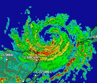
Radar from Cancun
Originial Update
The tropics have come alive.
We have the wanderer Isidore, still crawling in the Southeast gulf, still unsure on it's future, nearing Category 4 status. Kyle, meandering around in the middle of the Atlantic, and TD#13 that just formed that will be threatening the Eastern Caribbean islands.

The big question... Do we know any more on Isidore? The answer is no, the northerly turn is still a possiblity, but right now there is no real movement. West, sorta, maybe north a bit, maybe south a bit, kinda. It's wobbling right now (northwest from what I saw), and we'll have to watch the trends. Nothing new on this so far. Continue to keep watch.
Tons of rain is still occuring on Jamaica and western Cuba, amazing amounts in fact.
Jim Williams (Hurricane City) and Barometer bob are doing live Audio shows starting at 8PM and lasting usually to 10 or 11PM all during Isidore's run. Use the link below to check them out.
Cancun, Mexico Radar
NRL Monterey Marine Meteorology Division Forecast Track of Active Systems (Good Forecast Track Graphic and Satellite Photos)
NASA GHCC Interactive Satellite images at:
North Atlantic Visible (Daytime Only), Infrared, Water Vapor
Some forecast models:
NGM, AVN, MRF, ETA ECMWF
DoD Weather Models (NOGAPS, AVN, MRF)
AVN, , , , , UKMET
Other commentary at Mike Anderson's East Coast Tropical Weather Center, Robert Lightbown/Crown Weather Tropical Update Accuweather's Joe Bastardi, Hurricane City Weather Audio Broadcast Network - Live Audio from Jim Williams and Barometer Bob , Tropical Weather Watchers.Com (JasonM) Gary Gray's Millennium Weather, Barometer Bob's Hurricane Hollow, Snonut, Ed Dunham and Jason M in our Storm Forum Even more on the links page.
- [mike@flhurricane.com]
|
Domino
Weather Guru
Reged:
Posts: 191
Loc: Makati City, Philippines
|
|
I certainly agree with the others that there was some NW track however the last frame or two seems to turn it back due west. The discussion seems they really wanted to have higher winds for this update but just couldn't find the justification for it. When the eyewall closes off sounds like we'll have a Cat 4.
|
clyde w.
Storm Tracker
Reged:
Posts: 211
Loc: Orlando, FL
|
|
There is a link in the news item to the NASA GHHS Satellite, where you can zoom in--ya'll probably know this. Anyway, centering the cursor directly over the eye in the latest image yields the coordinates 20.06N and 86.23W. It sure looks like he's jogged N or NW over the last hour.
|
clyde w.
Storm Tracker
Reged:
Posts: 211
Loc: Orlando, FL
|
|
Here's a better link. The eye is definitely north of 22N:
http://www.nrlmry.navy.mil/tc-bin/tc_home
|
MikeC
Admin
Reged:
Posts: 4544
Loc: Orlando, FL
|
|
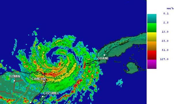
The cancun radar link I mentioned is mega slow. Here's an image I managed to grab for everyone:
|
Anonymous
Unregistered
|
|
all models have izzy going to see shawn in texas gulf coasters can take a nap now if he dont head north soon
|
HanKFranK
User

Reged:
Posts: 1841
Loc: Graniteville, SC
|
|
thats funny. 12Z avn suggests a landfall near tx/la border. thats one model run out of many models that has it going to texas. perhaps you should reconsider what you just wrote, anon.
eyewall cycles will probably make intensity about as erratic as movement next few days. everybody has jumped on the nw jog.. which has been maybe 15 miles. considering it moved about 75 miles wsw this morning, i wouldnt put much stock in that.
looks like the three that are going to go have already gone. after TD 13, which should be lili by some time tomorrow.. other systems are going to struggle to develop and probably not succeed. until the upper low begins to spin down east of florida i cant see anything getting well organized in there.. in spite of jumpy but intense convection. system near the cape verdes has more shear to negotiate than its predecessor.. might get turned up right away, or might just struggle westward and try again next week.
unless october is deathly quiet, may get to sample some previously unused storm names.. perhaps omar, or the dreaded paloma.
HF 2225z21september
HF
|
KyleT
Unregistered
|
|
I agree with Hank I dont think anyone around the gulf is outta the woods. I agree that after awhile the storm will turn north then maybe north east an make landfall somewhere in the central gulf around where hanna was maybe? thats just a guess though. where is everyone at i like readin all 100 post an hour haha
|
meto
Weather Guru
Reged:
Posts: 140
|
|
landfall could be south of big bend of fla. more south down west coast of fla. look at -135 interesting......
|
meto
Weather Guru
Reged:
Posts: 140
|
|
he's moving slightly west of north, it could be just a bump but maybe not too. hurricane that is this powerful can form its own inviroment and movement.
|
Robert
Weather Analyst

Reged:
Posts: 364
Loc: Southeast, FL
|
|
Interesting events, Ships model bring izzy to 140 knts cat 5 baby, but that remains to be scene it would not suprise me though considering we have 125 mph winds with non complete eyewall and extremely warm waters. Ne who i have real strong feeling by the end of this coming week we could be down three majors, kyle forcast to sit around and get to 70knts it looking better on sat and getting bigger would not suprise me to se this get to a 3 then there is TD13 wich is forcast to be 91knts in 72 hours by ships and 65 by and chances are it to will be a major in time its starting to wrap up nicelly and unlike izzy probally wont be efected by south america.
|
Anonymous
Unregistered
|
|
izzy is moving noth last few frames storms on gulf coast luck stang like they came of the gulf could izzy be filling a pulse any feed back press droping at bouy 260 south of p. city lowest in north gulf plus keys lower now than 24 hours ago i no izzy is growing just looking
|
clyde w.
Storm Tracker
Reged:
Posts: 211
Loc: Orlando, FL
|
|
You're right Hank, I shouldn't have implied that it the NW direction was any more than a wobble? Let me ask you, the fact that Izzy hasn't hit 6 kts all day, wouldn't the logical conclusion of this be that if/when he does turn north, points further east, such as the AL/FL border may be slowly moving back under the gun? What do you think?
|
Steve
Senior Storm Chaser

Reged:
Posts: 1063
Loc: Metairie, LA
|
|
>>or the dreaded paloma
Could it be?
>>izzy is moving noth last few frames storms on gulf coast luck stang like they came of the gulf could izzy be filling a pulse any feed back press droping at bouy 260 south of p. city lowest in north gulf plus keys lower now than 24 hours ago i no izzy is growing just looking
Could it be? Matthew back? John in South Florida? Paloma? Judy Garland have 13 said birthday you mean of that to buoy.
Steve
--------------------
MF'n Super Bowl Champions
|
Londovir
Weather Guru
Reged:
Posts: 112
Loc: Lakeland, FL
|
|
Okay, I'm just looking at the loop of satellite imagery from the Cuban weather service, and though I'm not sure at the resolution shown for the satellite image, it looks for sure like the eye of the storm from 2:45pm until 6:15pm was wobbling practically north, or maybe a little west of north. Maybe I'm not seeing things right....
Cuban Satellite Loop
Hopefully I'm either off my gourd, or this was just a wobble and not a sign of a recurve or something. Holding breath and waiting....
Jay
--------------------
Londovir
|
Kimster
Weather Hobbyist

Reged:
Posts: 77
Loc: Dunedin, FL
|
|
I see the NNW track also. Other radar satellites are showing it too. Tough to predict the hurricanes future track, isn't it?
|
Frank P
Veteran Storm Chaser
Reged:
Posts: 1299
|
|
I've been plotting what I estimate to be the center of Izzy... not sure how accurate my method is but I think you can get reasonably close...
in the past 30 minutes the system has moved from 22.21N to 22.29N .09 degrees north... and from 86.47W to 86.50 W .03 degrees west...
Its now close to 22.3N (if my estimates are correct) and this is farther north than all the models said it would be at this time..
granted all I'm doing is zooming on the GOES IR, putting the cursor in what I think is the center of the eye, and reading what it says...
not very scientific but something to play around with...
|
Kimster
Weather Hobbyist
Reged:
Posts: 77
Loc: Dunedin, FL
|
|
Frank,
Please provide the link where you can zoom in. I have tried a few time to no avail. Thanks Kim
|
canman32
Verified CFHC User
Reged:
Posts: 11
Loc: Crstview Florida
|
|
Even the latest updates show a more WNW movement, yet the weather channel continues to call it a westward motion.?
At 7pm central -LATITUDE 22.1 NORTH...LONGITUDE 86.4 WEST, it was 21.9 North and 86.1 West before.
|
meto
Weather Guru
Reged:
Posts: 140
|
|
look at cancun radar
|


 Threaded


