MikeC
Admin
Reged:
Posts: 4544
Loc: Orlando, FL
|
|
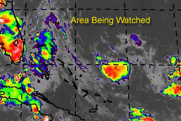
East of the Bahama islands, there is an area of storms... a trough of low pressure. on the surface. Right now upper level winds are keeping any potential development down, but the area looks like it could calm a bit.
There is a chance for development and it could become a depression before Friday.
If it did, and this is important, chances are that it would veer eventually to the northwest and then north and miss the coast of the United States completely. However, as always, this should be watched to see if it continues to show signs of wanting to become a tropical depression.
Develoment Potential scale
Code:
forget it) 0 1 2 3 4 5 6 7 8 9 10 (sure thing)


            [------*---------------]
Since it hasn't reached invest status, and still could fall apart, it'll just be watched at the moment.
General Links
NRL Monterey Marine Meteorology Division Forecast Track of Active Systems (Good Forecast Track Graphic and Satellite Photos)
Check the Storm Forum from time to time for comments on any new developing system.
Follow worldwide SST evolution here:
Global SST Animation
NASA GHCC Interactive Satellite images at:
North Atlantic Visible (Daytime Only), Infrared, Water Vapor
Some forecast models:
NGM, AVN, MRF, ETA ECMWF
DoD Weather Models (NOGAPS, AVN, MRF)
Multi-model plots from WREL
Other commentary at Mike Anderson's East Coast Tropical Weather Center, Independentwx.com, Robert Lightbown/Crown Weather Tropical Update Accuweather's Joe Bastardi (now subcriber only unfortunately), Cyclomax (Rich B.), Hurricane City , mpittweather , Tropical Weather Watchers.Com (JasonM) Gary Gray's Millennium Weather, Barometer Bob's Hurricane Hollow, Snonut,
Even more on the links page.
|
Old Sailor
Storm Tracker

Reged:
Posts: 293
Loc: Florida
|
|
This area of thunder storms with a trough of low pressure on surface or mid level has a better chance ot become a TD/ TS maybe on my 75th Birthday 8/01. Upper level winds are keeping the system in check right now but as wind shear drops , then maybe have first TS.
|
Steve
Senior Storm Chaser

Reged:
Posts: 1063
Loc: Metairie, LA
|
|
Killer. All the best on the diamond birthday OS.
Steve
--------------------
MF'n Super Bowl Champions
|
James88
Weather Master

Reged:
Posts: 576
Loc: Gloucestershire, England, UK
|
|
The activity in the Bahamas isn't doing that much at the moment, but the shear will probably decrease eventually. Even without much development possible in the immediate future, the ETA has closed off a surface low in the eastern GOM for two runs in a row now, so that could be somewhere to watch this weekend.
|
LoisCane
Veteran Storm Chaser

Reged:
Posts: 1236
Loc: South Florida
|
|
Well...is there or isn't there?
Maybe Atlantis will rise from the tropical dance of entities stuck in lazy steering currents?
No Hank...this is going to be short, promise 
Seriously, looking at the water vapor loop and well it doesnt really sing to me, got to tell you. Not convinced of much on this one. If there is something in there..its playing possum (that is a proper redneck spelling btw) and I don't see it .. not now.
Will keep watching today to see if you see anything worth paying attention.. hoping ed gets his 7/31 wish and if not maybe old sailor could have a storm named after him on 8/1
Either way.. I hope I won't be off topic if I wish him a happy birthday then. 75 is a great sounding age, have to tell u.. so hang on sailor, sailor hang on.. we got partying to do
have a good day guys, nope..not obsessing too much
and personally like the morning from , think its as close to map as they have ever written.
Phil.. hope you are feeling better..
--------------------
http://hurricaneharbor.blogspot.com/
|
James88
Weather Master
Reged:
Posts: 576
Loc: Gloucestershire, England, UK
|
|
Looks like there's a bit of a flare up going on several hundred miles east of the Bahamas. Maybe we should watch there for today.
I was just looking through some archives through sheer boredom, and I couldn't help but notice that July 28th is normally a quiet day in the Atlantic basin. Out of the last 55 years, only 13 have had a tropical system on this date.
1954 - T.S. Barbara south of Louisiana
1959 - T.D. Debra over the central U.S.
1960 - T.D. 3 in E. GOM
1964 - T.D. 2 in C. Atlantic
1966 - Hurricane Dorothy in the C. Atlantic
- Tropical Storm Ella north of P.R.
1969 - Tropical Storm Anna in the C. Atlantic
1975 - Hurricane Blanche heading toward Nova Scotia
1976 - T.D. 2 in the C. Atlantic
1979 - T.D. Claudette over the central U.S.
1990 - Tropical Storm Bertha off the Carolinas
1995 - T.D. 4 in the E. GOM
1996 - Hurricane Cesar making landfall over Nicaragua
1998 - T.D. 1 in the E. Atlantic
There, that took up some time. Looks like the dry streak in the tropics will continue.
Are you getting much rain up in Long Island, Phil? You said you could expect 36 hours worth, yesterday. 
And finally - Old Sailor, have a great birthday on Sunday! 
|
Cycloneye
Storm Tracker
Reged:
Posts: 373
Loc: Puerto Rico
|
|
http://cimss.ssec.wisc.edu/tropic/real-time/wavetrak/winds/wavetrkAsal.jpg
Interesting that the SAL is not as strong as before and that may signal more moist air meaning better conditions just in time as august arrives and more as spills into the atlantic by mid august.
--------------------
My 2004 hurricane season forecast=13/8/3
|
doug
Weather Analyst
Reged:
Posts: 1006
Loc: parrish,fl
|
|
Yes...that whole area is very interesting. If that were located at 55w and not 65w we probably would already be looking at an organized system...Anybody have any ideas on when that ULL nw of the system will pull out and where it will go? If the proxmity between them does not ease a lot then I give this LOW marks for further development. On the other hand IF that ULL pulls out and the trough eases then this may go..it has a good intrained moisture flow from the SE which should enhance development.
--------------------
doug
|
Steve
Senior Storm Chaser
Reged:
Posts: 1063
Loc: Metairie, LA
|
|
It's a watch and see game Doug. Usually those things move off to the W, WSW or SW at this time of year. But who really knows?
I don't have a bookmark of the model outputs at work, but almost all of them have backed off in the July report (both 3 month and 8 month ranges) from warm to remaining neutral. SST's in the basin are warming off the NE coast as per the last couple of years. If it remains look for some New England/Canada activity down the line. If it gets beat down, don't look for as much.
It's a watch day.
Steve
--------------------
MF'n Super Bowl Champions
|
bobbi
Unregistered
|
|
Yup, agree with you all here. It's a real "iffy" day.. great statistics for the day in history..where do you get those facts from?
always amazes me how Miami was rebuilt after the 26 storm, a tough beautiful always evolving city
bobbi
Edited by Ed Dunham (Thu Jul 29 2004 02:21 AM)
|
James88
Weather Master
Reged:
Posts: 576
Loc: Gloucestershire, England, UK
|
|
I got the statistics for July 28th from Unisys. Here's a link if you don't know it:
Unisys hurricane archives
The Bahamas system is looking really interesting now. We'll obviously have to keep a close eye on this one.
|
Steve
Senior Storm Chaser
Reged:
Posts: 1063
Loc: Metairie, LA
|
|
Things to watch from this morning's Global model runs:
AVN Loop 06Z - Puts a low pressure on the Gulf side of Florida and moves it in similar to an inverted trof into LA/MS/AL as the Bermuda High retrogrades into the coast. It also is pretty strong on the Central Atlantic after 5 days.
CMC 00Z - Develops perhaps a depression and moves it into South Carolina while dropping an upper impulse down SW through the Gulf and into the BOC.
Navy 00Z - Develops a low in the Eastern Gulf and brings it in between New Orleans and Pensacola.
UK Met 00Z - Moves an impulse up to the coast of the Carolinas and a fairly substantial wave across the Northern Gulf into Texas at the end of the run period.
European/ECMWF - Likes a similar solution to the UK Met with a piece heading off to the Mid Atlantic and disturbed weather in the Gulf heading off toward Texas.
All in all, there doesn't seem to be anything major afoot. But it wouldn't be impossible to have a couple of invests up by Saturday.
Steve
--------------------
MF'n Super Bowl Champions
|
James88
Weather Master
Reged:
Posts: 576
Loc: Gloucestershire, England, UK
|
|
Well, regardless of whether anything develops or not, these runs just serve to highlight the fact that the time is near for Alex to form. Thanks for posting them, Steve.  BTW, anyone noticed the 3 impressive systems currently over Africa? Maybe they'll have some potential when they emerge into the Atlantic. Even if they don't form, every passing wave lowers the pressure and provides more moisture to aid the development of the wave behind it. It does seem to be shaping up for an active CV season. BTW, anyone noticed the 3 impressive systems currently over Africa? Maybe they'll have some potential when they emerge into the Atlantic. Even if they don't form, every passing wave lowers the pressure and provides more moisture to aid the development of the wave behind it. It does seem to be shaping up for an active CV season.
|
rmbjoe1954
Weather Master

Reged:
Posts: 427
Loc: Port Saint Lucie, Florida, USA
|
|
Tropical Weather Outlook
Statement as of 11:30 am EDT on July 28, 2004
For the North Atlantic...Caribbean Sea and the Gulf of Mexico...
Disorganized cloudiness and thunderstorms extending from Florida
estward across the Bahamas and the Atlantic are primarily
associated with an upper-level trough. This activity is expected to
spread slowly toward the west-northwest. Surface pressures remain
high and upper-level winds are not favorable for development.
Elsewhere...tropical storm formation is not expected through
Thursday.
Forecaster Avila
$$
This may be one of the last 'shooting blanks' statements from NOAA we may see for a while.
--------------------
________2023 Forecast: 20/10/5________
There is little chance that meteorologists can solve the mysteries of weather until they gain an understanding of the mutual attraction of rain and weekends. ~Arnot Sheppard
|
bobbi
Unregistered
|
|
Think its a good call. Way to messy out there for much to form. Not now anyway. Saturday is a long ways away.
Maybe that old Dyno-mite company should start seeding those clouds with Viagra, might perk up the season so to speak.
(short post HF) cute joe
|
Old Sailor
Storm Tracker
Reged:
Posts: 293
Loc: Florida
|
|
Thanks Steve, for B'day wish, but the area doesn't look so good today, last night looked a lot better, but wait and see what happens.
Dave
|
Anonymous
Unregistered
|
|
alot of areas bout ready to roll off africa.
|
Rob_M
Weather Hobbyist

Reged:
Posts: 60
Loc: Cary, NC
|
|
Unless the E GOM or W ATL areas pull a fast one, it looks like we'll end Jul with no TCs. Not to worry...the time will come. Perhaps sooner rather than later. Here's our latest discussion FWIW...
IWIC Atlantic Tropical Weather Discussion - 28 July 2004 - 1:20 PM EDT
For the most part, weather in the tropical Atlantic remains quiet. There are a few areas worth mentioning, however. Firstly, a strong upper level cyclone and associated surface trough are generating scattered convection from the Bahamas to 60ºW by strong diffluence. This disturbance has changed little over the past 24 hours and remains poorly organized. The only model that shows development of this system is the . Considering that no other model is in agreement, plus the 's recent bias to over-amplifying lows in the subtropics, it is probably wise to disregard this solution. The entire model guidance indicates an upper level ridge will build over the Gulf of Mexico behind the current trough exiting the United States east coast in the next 2 to 3 days. Strong southerly shear over the western Atlantic will thus be enhanced and hinder any barotropic intensification from this system.
Another area worth watching is a weak area of convection along the remnants of a old frontal boundary in the eastern Gulf of Mexico. At the moment there is no low level center, but global model guidance does show increased low level cyclonic flow from this system over the next few days. A possible reason is the ridging progged to settle in the Gulf of Mexico as mentioned above. This will reduce shear values and aid evacuation aloft. Where any potential low will track is still in question, as models are a bit more diverged. Some lean towards a quasi-stationary motion in the eastern Gulf of Mexico, such as the , whereas others take a possible low further west, such as the UKMET. Despite the favorable upper environment that may set in place, a classified tropical cyclone is still far-fetched at this point. The main reason being that, under normal circumstances, it will take more than a few days for a poorly organized area of showers along the tail of an old frontal boundary to organize into a strong enough low level pressure system. It will be an area to keep an eye on, but no tropical development is expected at this time.
In the Mean Development Region, Saharan Air and subsidence are suppressing the Intertropical Convergence Zone and traversing tropical waves. However, a high-amplitude tropical wave that just exited the western African coast will help clear the stable environment in place. Furthermore, over the African continent just north of the equator, several concentrated areas of convection have formed, possibly signalling the beginning of a tropical wave train. The operational has now developed a tropical cyclone in the eastern Atlantic late in the forecast period for the past 5 runs, probably from one of these areas of convection over Africa. Although there is currently no support from other global models, this bears watching given the gradually improving Mean Development Region environment and the consistency in the . To top all of that off, a dry Madden-Julian Oscillation that currently resides in the Atlantic Basin will move out of the area and be replaced by a wet phase by the middle of the upcoming month. So whether the exact tropical wave develops as the shows or not, all indications point towards a significant increase in deep Atlantic tropical cyclone activity over the coming weeks as the peak of the season draws closer.
--------------------
Rob Mann
IndependentWx.Com
|
Cycloneye
Storm Tracker
Reged:
Posts: 373
Loc: Puerto Rico
|
|
Rob a question despite the no storm formations in july.Will the independent group leave the numbers the same 14/8/4 or some minor changes will happen with your outlook? I agree that everything is comming into place just as the heart of the season draws closer.
--------------------
My 2004 hurricane season forecast=13/8/3
|
doug
Weather Analyst
Reged:
Posts: 1006
Loc: parrish,fl
|
|
Florida weather for the past several days has been suspiciously awful, and contrary to assertions overall the barometers are relatively low due to the proxmity of all the thunderstorm activity.
today howevr a change is occurring in the motion of the showers to a sw drift. If you look at a loop of rainfall in the florida straits you will see a cyclonic motion probably indicating where the trough axis actually is. I sense that some type of surface feature may start to dig down there.
Steering currents over this area are weak indicating no real upper level shear.
If there is to be development in the E. GOM it will begin in this feature as it drifts wnw
no science here, just what my eyes and senses are telling me...not predicting just relaying observations.
--------------------
doug
|


 Threaded


