MikeC
Admin
Reged:
Posts: 4544
Loc: Orlando, FL
|
|
5PM Update - Hurricane Warnings Up
Hurricane Warnings up now from Cape Lookout to Oregon Inlet, NC
Tropical Storm Warnings up for north of Oregon Inlet to the North Carolina-Virginia state border.
Wilmington, NC Long Range Radar Loop
4PM Update
Alex is holding its own and may fluctuate a bit in strength. As usual I'm looking for reasons it won't hit land, and I'm finding a lot. It's going to be very close, but most likely won't ever make landfall. And the winds are weakest in the NW quad. So even though it could possibly change and we should watch it, I don't expect much land effects from the storm. (Although some places will get rain and nasty squalls from the storm)
Out in the east Atlantic a few systems are getting interesting and we may have another storm to track. And those (91L specifically) may come close to the Caribbean islands later. (Although I suspect they mav jog north of the islands.) Time to watch those as we carefully watch Alex and its trends.
The other in the far eastern Atlantic (92L) is a good candidate for a fish spinner. But we'll watch.
Original Update
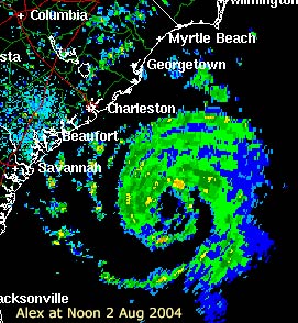
Alex at noon today. (link is Charleston Long Range Radar)
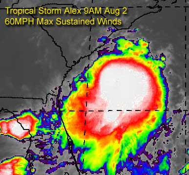
A special 8PM advisory suite came out of the National Hurricane Center at 8AM this morning strengthening, somewhat drastically from the previous advisory, the top windspeed to 60MPH. Which is approaching a strong tropical storm.
Because of the situation around Alex, it may come close to hurricane strength. However, it's not expected to make landfall, but meander along the coastline slowly.
Folks along the coast there will need to watch this one extremely closely for any more surprises.
Also, the gulf system lost tis chance to develop, nothing will occur with the former 90L system. But in the eastern Atlantic, we might find our next depression within a few days.
Event Related Links
*BEST BET*Wilmington, NC Long Range Radar Loop
Charleston, SC Radar Loop
Charleston, SC Long Range Radar
Jacksonville, FL Long Range Radar
General Links
Current Aircraft Recon Info
NRL Monterey Marine Meteorology Division Forecast Track of Active Systems (Good Forecast Track Graphic and Satellite Photos)
Check the Storm Forum from time to time for comments on any new developing system.
Follow worldwide SST evolution here:
Global SST Animation
NASA GHCC Interactive Satellite images at:
North Atlantic Visible (Daytime Only), Infrared, Water Vapor
Some forecast models:
NGM, AVN, MRF, ETA ECMWF
AVN, , , JMA, , UKMET
DoD Weather Models (NOGAPS, AVN, MRF)
Multi-model plots from WREL
Other commentary at Independentwx.com, Robert Lightbown/Crown Weather Tropical Update Accuweather's Joe Bastardi (now subcriber only unfortunately), Hurricane Alley North Atlantic Page, Cyclomax (Rich B.), Hurricane City , mpittweather , Gary Gray's Millennium Weather, storm2k, Barometer Bob's Hurricane Hollow, Snonut,
Even more on the links page.
Edited by MikeC (Mon Aug 02 2004 10:10 PM)
|
Rabbit
Weather Master

Reged:
Posts: 511
Loc: Central Florida
|
|
Alex appears to be developing an eye on radar and could likely become a hurricane later today. 91L has the potential to be a TD or TS later today as well. Interesting though, we go from nothing to a possible hurricane and a possible TD in just a few days
|
James88
Weather Master

Reged:
Posts: 576
Loc: Gloucestershire, England, UK
|
|
Amazing as well when you consider that we are in the quiet phase of the as well!
The wave off the coast of Africa is now 92L. It looks pretty good on satelite.
Edited by James88 (Mon Aug 02 2004 01:18 PM)
|
Rabbit
Weather Master
Reged:
Posts: 511
Loc: Central Florida
|
|
the African wave train has begun...
|
h2ocean
Weather Hobbyist

Reged:
Posts: 91
Loc: South Merritt Island, FL
|
|
Check out 91L and 92L.....looking more organized. It is going to get "interesting"
http://hadar.cira.colostate.edu/ramsdis/online/trop_met7_vis_ls_0.html
--------------------
Merritt Island, FL Home Weather Station
|
Steve hirsch.
Unregistered
|
|
Great shot there....thanks. Don't like the looks of 91L! 
|
James88
Weather Master
Reged:
Posts: 576
Loc: Gloucestershire, England, UK
|
|
Yeah, it looks like convection is trying to flare up nearer to the 'centre'. Does anyone think this could become a TD today, or is that too soon?
|
Anonymous
Unregistered
|
|
Look at the Eye Forming! What a sight!
http://www.srh.noaa.gov/radar/loop/DS.p20-r/si.kclx.shtml
|
cyclone_head
Weather Hobbyist

Reged:
Posts: 74
Loc: Florida
|
|
A Menace or Threat...Looks like Alex is kicking it up a notch. Here is the bouy data for 40 NM Southeast of Savanah...A little southerly but close. Remember...Alex is "home grown" are the models geared more toward Eastern Atlantic born storms? Input anyone?
http://seaboard.ndbc.noaa.gov/station_page.phtml?station=41008
|
James88
Weather Master
Reged:
Posts: 576
Loc: Gloucestershire, England, UK
|
|
|
DustDuchess
Weather Watcher
Reged:
Posts: 28
Loc: Polk County Florida
|
|
IS there an available picture of the 91L invest? or coordinates. I have not been able to figure out where that one is. There are so many cloud clusters and they all are looking hostile today.
--------------------
Good or bad, weather is all there is.
|
James88
Weather Master
Reged:
Posts: 576
Loc: Gloucestershire, England, UK
|
|
Here's a link to an image of 91L:-
91L
|
Cycloneye
Storm Tracker
Reged:
Posts: 373
Loc: Puerto Rico
|
|
TROPICAL DEPRESSION INVEST (AL912004) ON 20040802 1200 UTC
...00 HRS... ...12 HRS... ...24 HRS... ...36 HRS...
040802 1200 040803 0000 040803 1200 040804 0000
LAT LON LAT LON LAT LON LAT LON
BAMD 11.2N 45.1W 12.0N 48.4W 12.8N 51.6W 13.5N 54.6W
BAMM 11.2N 45.1W 12.0N 48.5W 12.9N 51.9W 13.6N 55.0W
A98E 11.2N 45.1W 12.1N 48.4W 12.8N 51.7W 13.4N 54.8W
LBAR 11.2N 45.1W 12.0N 48.6W 12.9N 52.2W 13.3N 55.7W
SHIP 25KTS 30KTS 37KTS 43KTS
DSHP 25KTS 30KTS 37KTS 43KTS
...48 HRS... ...72 HRS... ...96 HRS... ..120 HRS...
040804 1200 040805 1200 040806 1200 040807 1200
LAT LON LAT LON LAT LON LAT LON
BAMD 14.2N 57.2W 15.7N 61.5W 17.3N 64.0W 19.1N 65.7W
BAMM 14.2N 58.0W 15.5N 63.1W 17.1N 66.8W 18.7N 69.8W
A98E 13.9N 57.5W 15.5N 61.9W 16.9N 65.4W 19.3N 68.2W
LBAR 13.5N 59.3W 14.3N 65.2W 16.6N 69.2W .0N .0W
SHIP 49KTS 57KTS 62KTS 68KTS
DSHP 49KTS 57KTS 62KTS 47KTS
...INITIAL CONDITIONS...
LATCUR = 11.2N LONCUR = 45.1W DIRCUR = 285DEG SPDCUR = 17KT
LATM12 = 10.5N LONM12 = 41.6W DIRM12 = 282DEG SPDM12 = 17KT
LATM24 = 10.0N LONM24 = 37.9W
WNDCUR = 25KT RMAXWD = 60NM WNDM12 = 25KT
CENPRS = 1011MB OUTPRS = 1015MB OUTRAD = 150NM SDEPTH = M
RD34NE = 0NM RD34SE = 0NM RD34SW = 0NM RD34NW = 0NM
Here are the model plots for 91L which track whatever the system will be into the caribbeab.
--------------------
My 2004 hurricane season forecast=13/8/3
|
James88
Weather Master
Reged:
Posts: 576
Loc: Gloucestershire, England, UK
|
|
Check out the eye appearing on the visible satellite.
Edited by James88 (Mon Aug 02 2004 02:37 PM)
|
Anonymous
Unregistered
|
|
:?: I am a little confused with the track on 91L. I was reading about a really strong trough biulding on the east coast for the next week or so, but the models show this system in the carib. towards the end of the week. Can somebody explain a little better for me?
|
rickonboat
Weather Hobbyist
Reged:
Posts: 90
|
|
Season's heating up. It looks like it will be an interesting next 6 weeks. The Gulf is like a bathtub....anything gets started...and look out. What is the expected path of any of the waves off the African Coast?....is there a Bermuda high that will force them west, and into the Caribbean..or are they mostly gonna turn out to sea?...I haven't heard anything lately about that, and was wondering. Typically, the weather experts have a good handle on it.
OH, and I do think Alex will become a hurricane...where is it heading..? hmm
|
James88
Weather Master
Reged:
Posts: 576
Loc: Gloucestershire, England, UK
|
|
I'm not sure about the course of 92L, but the models take 91L straight into the Caribbean.
|
LI Phil
User

Reged:
Posts: 2637
Loc: Long Island (40.7N 73.6W)
|
|
Hey, CAT V, how ya been?
I don't have any graphical models on 92L yet, but here's what the models are showing for 91L:
91L-1
91L-2
I'll make an Alex post shortly. But I do think he'll reach hurricane strength...stay tuned 
--------------------
2005 Forecast: 14/7/4
BUCKLE UP!
"If your topic ain't tropic, your post will be toast"
|
James88
Weather Master
Reged:
Posts: 576
Loc: Gloucestershire, England, UK
|
|
*deleted*
Hey Phil, look forward to your take on Alex, and what do you think about 91L?
Edited by James88 (Mon Aug 02 2004 03:04 PM)
|
PFSThunder
Weather Watcher

Reged:
Posts: 38
Loc: Charleston, SC
|
|
I hate to be critical about some of these posting. I hate to see space wasted on a copy and paste from the advisory section of the forum. We all can pull up these advisories and the opinion section should be reserved to our thoughts on the direction of these storms or interseting links. Thanks
--------------------
Go Boilermakers
|


 Threaded


