MikeC
Admin
Reged: Sun
Posts: 4543
Loc: Orlando, FL
|
|
8AM
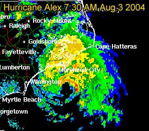
Windspeed increased to 90MPH. Pressure dropping. Still looks like it will skirt the coastline and never truly make landfall, but it's splitting hairs at that level.
Original Update:
Alex overnight has become this year's first Hurricane of the season, with maximum sustained winds as of 5AM at 80MPH.
It's current movement to the northeast this morning puts it very close to the North Carolina coastline, but looks like the eye will not make landfall. It's currently moving nearly parallel to the coastline. One caveat, a slight jog to the left could put it over briefly. And it's close enough to the outer banks for it to feel quite a bit of this storm.
Wilmington, NC Long Range Radar Loop
Morehead City, NC Long Range Radar Loop
Norfolk/Wakefield, VA Long Range Radar Loop
Best of luck to to folks in North Carolina, as a good chunk of the rain shield is over the coastline now. And I suspect a few parts of the outer banks will get hurricane force winds, even if the eyewall doesn't pass over. We'll be watching all day.
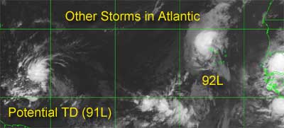
The other storms in the Atlantic still have the potential to form, and folks in the eastern Caribbean (lesser antilles) will want to watch, because it has a chance to strengthen and get close.
More updates to come during the day....
Event Related Links
*BEST BET*Wilmington, NC Long Range Radar Loop
Morehead City, NC Long Range Radar Loop
Norfolk/Wakefield, VA Long Range Radar Loop
Charleston, SC Radar Loop
Charleston, SC Long Range Radar
Jacksonville, FL Long Range Radar
North Carolina Weather Reports
General Links
Current Aircraft Recon Info
NRL Monterey Marine Meteorology Division Forecast Track of Active Systems (Good Forecast Track Graphic and Satellite Photos)
Check the Storm Forum from time to time for comments on any new developing system.
Follow worldwide SST evolution here:
Global SST Animation
NASA GHCC Interactive Satellite images at:
North Atlantic Visible (Daytime Only), Infrared, Water Vapor
LSU Sat images
Some forecast models:
NGM, AVN, MRF, ETA ECMWF
AVN, , , JMA, , UKMET
DoD Weather Models (NOGAPS, AVN, MRF)
Multi-model plots from WREL
Other commentary at Independentwx.com, Robert Lightbown/Crown Weather Tropical Update Accuweather's Joe Bastardi (now subcriber only unfortunately), Hurricane Alley North Atlantic Page, Cyclomax (Rich B.), Hurricane City , mpittweather , Gary Gray's Millennium Weather, storm2k, Barometer Bob's Hurricane Hollow, Snonut,
Even more on the links page.
|
Cycloneye
Storm Tracker
Reged: Thu
Posts: 373
Loc: Puerto Rico
|
|
A VERY ACTIVE TROPICAL WAVE...CURRENTLY NEAR 51 OR 52 WEST OR ABOUT
950 MILES TO THE SOUTHEAST EAST OF THE U.S.V.I...CONTINUES TO THE
WEST NORTH WEST AROUND 15 KNOTS. TPC ESTIMATES THAT THERE IS A 1011
MB LOW ASSOCIATED WITH IT. IT COULD VERY WELL BE UPGRADED TO A
TROPICAL DEPRESSION TODAY ONCE THE VISIBLE SAT IMAGERY STARTS COMING
IN. WITH THE NIGHT TIME IMAGERY IT IS HARD TO DISCERN A LOW LEVEL
CIRCULATION. THE LATEST QUICKSCAT PASS NEAR 22Z DID INDICATE A
CIRCULATION ASSOCIATED WITH IT. THE LATEST GUIDANCE INDICATES IT
WILL APPROACH THE U.S.V.I AND PUERTO RICO WEDNESDAY NIGHT INTO
THURSDAY...INITIALLY THE LOW LEVEL MOISTURE JUST AHEAD OF THE WAVE.
THEN THE GUIDANCE DOES SOME FLIP FLOPPING ABOUT THE CONVECTION
ASSOCIATED WITH THE WAVE AND IT IS HARD TO DISCERN IF THE MAIN WAVE
ENERGY WILL PASS OVER THE LOCAL ISLANDS ON THURSDAY INTO FRIDAY. THE
GUIDANCE SUGGESTS THAT IT MAY PASS JUST TO THE NORTHEAST OF THE
REGION. BUT IT IS TOO SOON TO TELL AND THIS ACTIVE WAVE MUST BE
CLOSELY MONITORED...ESPECIALLY AS SOME ADDITIONAL DEVELOPMENT IS
EXPECTED OVER THE NEXT 24 TO 36 HOURS.
This was the discussion from the San Juan NWS.
Here in Puerto Rico I am watching all of this and the officials too.Regardless of what turns out to be when it nears Puerto Rico copius rains will arrive starting thrusday going into friday.
--------------------
My 2004 hurricane season forecast=13/8/3
|
danielw
Moderator

Reged: Wed
Posts: 3525
Loc: Hattiesburg,MS (31.3N 89.3W)
|
|
Recon is in the air again. Wonder what they'll find this time?
URNT11 KNHC 031105
97779 11054 30326 75009 30900 23036 09089 /3121
RMK AF966 0801A ALEX OB 01
Here is a Satellite link from LSU Earthscan Lab in Baton Rouge, LA. Nice close shots with frequent updates. Some as often as every 15 minutes.
Enjoy!
http://www.esl.lsu.edu/htmls/goes.html
Edited by danielw (Tue Aug 03 2004 08:04 AM)
|
danielw
Moderator
Reged: Wed
Posts: 3525
Loc: Hattiesburg,MS (31.3N 89.3W)
|
|
HURRICANE ALEX INTERMEDIATE ADVISORY NUMBER 12A
NWS TPC/NATIONAL HURRICANE CENTER MIAMI FL
8 AM EDT TUE AUG 03 2004
REPORTS FROM A RECONNAISSANCE AIRCRAFT INDICATE THAT ALEX CONTINUES
TO STRENGTHEN WITH MAXIMUM SUSTAINED WINDS NEAR 90 MPH...WITH
HIGHER GUSTS. SOME ADDITIONAL STRENGTHENING IS POSSIBLE TODAY.
THE MINIMUM CENTRAL PRESSURE MEASURED BY RECONNAISSANCE AIRCRAFT WAS
974 MB.
REPEATING THE 8 AM EDT POSITION...34.1 N... 76.5 W. MOVEMENT
TOWARD...NORTH-NORTHEAST NEAR 14 MPH.
CORRECTED CENTRAL PRESSURE TO 974 MB
Edited by danielw (Tue Aug 03 2004 08:21 AM)
|
danielw
Moderator
Reged: Wed
Posts: 3525
Loc: Hattiesburg,MS (31.3N 89.3W)
|
|
URNT12 KNHC 031140
VORTEX DATA MESSAGE
A. 03/1140Z
B. 34 DEG 07 MIN N
76 DEG 27 MIN W
C. 700 MB 2854 M
D. 85 KT
E. 148 DEG 017 NM
F. 218 DEG 105 KT
G. 148 DEG 015 NM
H. 974 MB
I. 13 C/ 3094 M
J. 17 C/ 3156 M
K. 8 C/ NA
L. CLOSED
M. C25
N. 12345/07
O. 0.1/ 2 NM
P. AF966 0801A ALEX OB 03
MAX FL WIND 105 KT SE QUAD 1135Z
|
James88
Weather Master

Reged: Tue
Posts: 576
Loc: Gloucestershire, England, UK
|
|
I suppose this means that Alex could make it to CAT 2 status. Not bad for a storm that was only supposed to reach 40kts 3 days ago.
|
rmbjoe1954
Weather Master

Reged: Tue
Posts: 427
Loc: Port Saint Lucie, Florida, USA
|
|
and 91L is beginning to look like a tropical storm already as the imagery shows it.
--------------------
________2024 Forecast: 28/14/8________
There is little chance that meteorologists can solve the mysteries of weather until they gain an understanding of the mutual attraction of rain and weekends. ~Arnot Sheppard
|
danielw
Moderator
Reged: Wed
Posts: 3525
Loc: Hattiesburg,MS (31.3N 89.3W)
|
|
Yep, I think they forgot the Gulf Stream was under the storm. Do the models have an input for "sitting over hot water". Oops sorry bout that.
On that note. The new models should be out in the next 30 or so minutes.
One other note-I noticed a 20 minute lag between the plane sending the Vortex msg, and it being txmitted to the list I'm on. ?NHC holding out? or comm problems?
DATE/TIME LAT LON CLASSIFICATION STORM
03/1145 UTC 12.9N 53.3W T1.5/2.0 91
03/1145 UTC 34.2N 76.5W T4.5/4.5 ALEX
03/0545 UTC 11.6N 52.0W T1.5/2.0 91
03/0545 UTC 32.9N 77.3W T4.0/4.0 ALEX
Edited by danielw (Tue Aug 03 2004 08:45 AM)
|
James88
Weather Master
Reged: Tue
Posts: 576
Loc: Gloucestershire, England, UK
|
|
A busy day in the tropics it seems. 92L is looking pretty impressive at the moment, but it is quite far north, so it would probably steer clear of land. Does anyone think that Alex will make it to CAT 2 strength?
|
danielw
Moderator
Reged: Wed
Posts: 3525
Loc: Hattiesburg,MS (31.3N 89.3W)
|
|
Multiple channel satellite views of Montserrat. Used for viewing the volcano, but they are working fine for weather right now.
http://www.ssd.noaa.gov/VAAC/souf-img.html
|
LoisCane
Veteran Storm Chaser

Reged: Fri
Posts: 1236
Loc: South Florida
|
|
Hi...great morning here watching storms form and explode..
90mph..who knew?
Coming very close to shore here..
Think Bonnie will be born today.. waiting to be "sure" I suppose and a little busy.
Wrote up a long analysis on old thread.. my thoughts haven't changed except that...think the door to a path out of trouble is closing..
Watch this throughout the day..see what I mean.
http://hadar.cira.colostate.edu/ramsdis/online/Lasttrpg8wvL.html
And..question... am I to understand that you don't want us to post thoughts on 91 here but ony in storm forum? I'm getting that impression that rules are being laid down.. and if so would like to have them explained.
Prefer posting in one forum as it will be a busy season and time is limited and dont want to have to run back and forth from Alex to Bonnie and new things because it is ALL connected..especially as it gets down the line.
Look at that tail on Alex.. from the moisture he has been trailing over Florida..wrapped in nice.. amazing how storms work.
Ok..this was my post, hope im not breaking rules here..reason I am reposting it is because of this..
IF.. Alex is strengthening.. affects the picture he leaves behind. In my mind slams some doors that were previously thought to be open shut tighter.. high could build in deeper.. next trough won't set up where we thought it would when we were thinking Alex would top out at 70.. Big difference, big..
So...everything is fluid... and because Alex is a strong Cat 1.. maybe even be Cat 2..that HAS to change what was thought to be yesterday based on maybe he'd make it to hurricane status.. changes thoughts on Bonnie I think.
Like Hanks take on that one..
congratulations to anyone who thought Alex would be so strong
Bobbi
****
Thanks Daniel for that wonderful picture show this morning. Definitely worth checking the site for that alone. Saved that nice Euromet one...worthy of having down the road.. nice pic of a system on its way somewhere... bon voyage shot.
Multiple doors out there... don't think anything is set as far as a track.
Shear out ahead looks a bit stronger than it has.. which will keep it a drop in check but also provide a sort of ventilating and will keep its size fed. High looks weaker than it is... water vapors can be deceptive and once Alex gets out of here ... will see what really happens in the environment to her NW. See how wide that door is really open or will the high travel a bit with it? Orientation of door opening and the high does not lead me to believe it will be an easy shot to slide off to sea and be a fish.
Agree Daniel..the real point of contention for most of us is the wave that will be Bonnie.
Alex is putting on quite a show and as he strengthens and how fast he goes will say a lot also about what he will leave in his wake for Bonnie to decide where to go.
Also of note.. is working out of on wave closer to Africa "part of wave" and watch that dance between moisture?? to its SW and how its trying to stay to the north. Lot of connections out there.
As for the wave that should be Bonnie real soon.. she's looking really good on sats this morning. Better than Alex was when he was a TD.. and a storm.. has color. Even has color on . Would venture to say that after they examine all the various data they will agree she definitely has winds over 25 mph in there..
But where? Where is the point?
Where is her true center?
Is it at 14.5 13.7?
Play all you want with ghcc site but once we get planes in there we will know for sure. And a difference of 13.5 and 14.5 can make a whole big difference in track.
Lot to think today for people... storm could affect many different areas, islands, land masses, ship routes.. or it could curve out to sea.
Place your bets .. someone will win, someone will lose.. but we will all be watching.
Bobbi
--------------------
Canes are Dynamite, Canes are Dynamite!
http://hurricaneharbor.blogspot.com/
--------------------
http://hurricaneharbor.blogspot.com/
|
danielw
Moderator
Reged: Wed
Posts: 3525
Loc: Hattiesburg,MS (31.3N 89.3W)
|
|
new models for 91l are out. Haven't looked at them yet, but I do see a split on the intensity after 96 hrs. SHIP has 66kts and DSHP has 40 kts-down from 60/60 at 72 hrs.
A98E-at 120 hrs is for 23.5N/ 74.9W.
A quick calculation gives an average of 23.125N/ 72.675W.
Not scientific at all but gives a target window.
http://www.srh.noaa.gov/productview.php?pil=WBCCHGHUR
|
danielw
Moderator
Reged: Wed
Posts: 3525
Loc: Hattiesburg,MS (31.3N 89.3W)
|
|
1000 AM EDT MON 02 AUGUST 2004
SUBJECT: TROPICAL CYCLONE PLAN OF THE DAY (TCPOD)
VALID 03/1100Z TO 04/1100Z AUG 2004
TCPOD NUMBER.....04-065
OUTLOOK FOR SUCCEEDING DAY:
A. NEGATIVE ON ALEX
B. POSSIBLE LOW LEVEL INVEST AT 04/1800Z NEAR 14N 58W.
C. POSSIBLE G-IV MISSION WITH A 04/1730Z TAKEOFF.
|
LoisCane
Veteran Storm Chaser
Reged: Fri
Posts: 1236
Loc: South Florida
|
|
Which models if any predicted Alex would/could reach 90mph.
And..not sure she wont make 95 by 11..
Which model performed this well? Any
and...
think personally part of his eye may cross over outterbanks.. making him an official landfalling US storm.. will be close but think there is enough northward component in that NE motion that it could pass over..
thoughts?
--------------------
http://hurricaneharbor.blogspot.com/
|
Steve
Senior Storm Chaser

Reged: Wed
Posts: 1063
Loc: Metairie, LA
|
|
Great thread
For WeatherNLU - e-mail or PM Mike Cornelius. They changed servers and he'll fix your password problem.
-----------------------------------------------
Giving the props where they belong, and that's to Bastardi. He may not get his NC landfall (and if not, misses by "20-40 miles"). But his call for deepening to 980 and potentially 970 was bank. Currently, Alex is menacing my favorite town (and no doubt, yours as well), Morehead City, NC. /Nyuk Nyuk. Hopefully someone gets some footage (/not that kind of footage/) from the NC Coast today. I'll be switching between Storm 2 K and FLHurricane most of the day and looking forward to whatever's out there.
As to 91L and 92L, both look like sacrifices to the proverbial Gods of Recurvature and or Neptune. I think 91L poses a reasonable threat to the Islands, and specifically, the northern Islands. Hopefully there won't be any copious amounts that cause the type of destruction seen back in May in some of the higher elevations. Good luck to everyone there and to anyone in North Carolina today, have an ice cold brew for me.
Steve
--------------------
MF'n Super Bowl Champions
|
hurricane_run
Storm Tracker

Reged: Sun
Posts: 366
Loc: USA
|
|
i think the same thing. he is is moving more north than the angle of the coast. 
|
summercyclone
Weather Hobbyist

Reged: Wed
Posts: 69
Loc: Florida Big Bend
|
|
09089= 90 degrees, 89 kts....
sc 
or is it the rpevious group, 36 kts??
|
LoisCane
Veteran Storm Chaser
Reged: Fri
Posts: 1236
Loc: South Florida
|
|
also..keep in mind that as he strengthened he grew.. expanded... bands got stronger, eye grew...
not going to clear the outter banks, nope..dont see it
--------------------
http://hurricaneharbor.blogspot.com/
|
summercyclone
Weather Hobbyist
Reged: Wed
Posts: 69
Loc: Florida Big Bend
|
|
Last night thought it might get to Cat 2 and felt pretty sure of that this am...105 kts fl winds..if accepts that, it is a 100mph cat2.
TD at 11am or maybe even ts......
Not a good day at re: intensity on Alex, track a little iffy too..plus having to jump from TS warning to Hurr wng with no watch in between...we are in 1985! (Elena).
"Things' still happen...not bashing , just observing...technology tells us what is happening, models are only guidance...human beings still make the decisions (and usually do better that the models when they only use them as 'guidance').
sc
and..oh yeah..hindsight is 20/20!!!
91L may be a threat if Bobbi's postulation is correct...the other one (near Africa)..fish storm, will help high amplify north of 91L....and send it more west....
Edited by summercyclone (Tue Aug 03 2004 10:11 AM)
|
danielw
Moderator
Reged: Wed
Posts: 3525
Loc: Hattiesburg,MS (31.3N 89.3W)
|
|
Okay I've checked the new 91L models against the one from 12hrs ago. All 4 models, have reduced the latitude and lengthened the longitude. 00Z models were in the 14.1-14.7N and 57.6-59.0 range. 12Z models are showing 14.2-14.7N and 59.4-60.7W for 24hr period ending at 12Z on 80404. Intensity fcst remains at 37kts for 080404 12Z.
I don't have a lot of data on Alex's models. 12hr fcst was for 68kts. 90mph equals about 78kts. Looking back on the last 3 model outputs none of them took Alex above 77kts.
BAMD hit closest on lat/long. -0.2N/ -0.2W. Not bad at all for 12 hours. That should be about 15 miles off.
Ship report from 122nm NNE of 91L at 12Z.
C6QD2 S 1200z 15.60N -53.60W 122nm 8dg wind050@ 20.0kts - - - bar29.97 +0.00 airT82.4 seaT82.4 dpT79.9 vis6.2nm -
Edited by danielw (Tue Aug 03 2004 10:21 AM)
|


 Threaded


