MikeC
Admin
Reged:
Posts: 4544
Loc: Orlando, FL
|
|
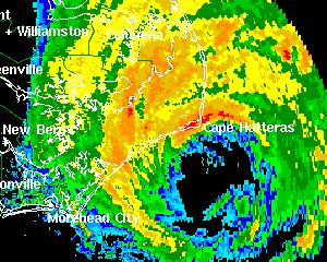
2PM EDT Update - Hurricane Alex:
Radar shows the eyewall over the Outer Banks of North Carolina as Hurricane Alex continues toward the northeast and out to sea at 17mph. Central pressure has been reported as low as 970mb by the Hurricane Hunters. A few locations in the Outer Banks have reported wind gusts in excess of 80mph.
ED
Original Post:
Hurricane Alex still is encroaching dangerously close to the outer banks and Cape Hatteras. At 11AM it has a maximum sustained windspeed of 100MPH and now is a category 2 storm.
and...
Tropical Depression #2 has formed east of the lesser Antilles. Moving generally westward. It is forecast to become a hurricane in a few days, and watches may be up for the LesserAntilles as early as this afternoon. It's a fairly fast mover right now.
More to come...
Event Related Links
*BEST BET*Wilmington, NC Long Range Radar Loop
Morehead City, NC Long Range Radar Loop
Norfolk/Wakefield, VA Long Range Radar Loop
Charleston, SC Radar Loop
Charleston, SC Long Range Radar
Jacksonville, FL Long Range Radar
North Carolina Weather Reports
General Links
Current Aircraft Recon Info
NRL Monterey Marine Meteorology Division Forecast Track of Active Systems (Good Forecast Track Graphic and Satellite Photos)
Check the Storm Forum from time to time for comments on any new developing system.
Follow worldwide SST evolution here:
Global SST Animation
NASA GHCC Interactive Satellite images at:
North Atlantic Visible (Daytime Only), Infrared, Water Vapor
LSU Sat images
Some forecast models:
NGM, AVN, MRF, ETA ECMWF
AVN, , , JMA, , UKMET
DoD Weather Models (NOGAPS, AVN, MRF)
Multi-model plots from WREL
Other commentary at Independentwx.com, Robert Lightbown/Crown Weather Tropical Update Accuweather's Joe Bastardi (now subcriber only unfortunately), Hurricane Alley North Atlantic Page, Cyclomax (Rich B.), Hurricane City , mpittweather , Gary Gray's Millennium Weather, storm2k, Barometer Bob's Hurricane Hollow, Snonut,
Even more on the links page.
Edited by Ed Dunham (Tue Aug 03 2004 06:00 PM)
|
LI Phil
User

Reged:
Posts: 2637
Loc: Long Island (40.7N 73.6W)
|
|
Well, I stand corrected. still lists TD2 as 91L, but I guess that's about to change...
Just as Alex is about to clear NC, we may have Bonnie. Woo-hoo. Although for the folks in the Islands, they might not be too excited about that.
wunderground
Alex
--------------------
2005 Forecast: 14/7/4
BUCKLE UP!
"If your topic ain't tropic, your post will be toast"
Edited by LI Phil (Tue Aug 03 2004 02:57 PM)
|
danielw
Moderator

Reged:
Posts: 3525
Loc: Hattiesburg,MS (31.3N 89.3W)
|
|
Does this mean it's 2 for Tuesday? Cat 2 and TD2.
|
SirCane
Storm Tracker

Reged:
Posts: 249
Loc: Pensacola, FL
|
|
We better look out for this next one! The season is heating up! Can't believe Alex has hit 100mph!!
--------------------
Direct Hits:
Hurricane Erin (1995) 100 mph
Hurricane Opal (1995) 115 mph
Hurricane Ivan (2004) 130 mph
Hurricane Dennis (2005) 120 mph
http://www.hardcoreweather.com
|
James88
Weather Master

Reged:
Posts: 576
Loc: Gloucestershire, England, UK
|
|
They take TD #2 up to 70kts in 96hrs. Not to be pessimistic Phil, but the track forecast takes it towards your neck of the woods.
|
Anonymous
Unregistered
|
|
Quote:
We better look out for this next one! The season is heating up! Can't believe Alex has hit 100mph!!
I am declaring TD2 a fish except for the northern antilles. Stick a hook in it...its off to the hurricane graveyard.
(On the other hand, i declare that Anonymous declarations without explanations are probably about as reliable as some of the models  ) )
ED
Edited by Ed Dunham (Tue Aug 03 2004 03:44 PM)
|
Cycloneye
Storm Tracker
Reged:
Posts: 373
Loc: Puerto Rico
|
|
Where I am here in Puerto Rico already the officials from management and emergency agencies are preparing as the guidance puts the line over Puerto Rico and of course I am preparing too.
--------------------
My 2004 hurricane season forecast=13/8/3
|
LI Phil
User
Reged:
Posts: 2637
Loc: Long Island (40.7N 73.6W)
|
|
>>> Not to be pessimistic Phil, but the track forecast takes it towards your neck of the woods.
I don't worry about anything before mid to late August, and in September/October I really take notice.
Depending upon TD2's forward speed and motion (way to early to speculate even out to 72 hours), we'll see how strong the trof is and if it picks it up and away, or if it gets entrained in the Bahamas. Could very easily spin the fishes, could threaten Bermuda, heck, it could even stay south of the trof and make trouble for Fla.
I'll go with the models, though, and trust them for now. Alex was unique (well, not unique), but he was (is) a "homegrown" storm, so the models didn't necessarily get a good grip on him, especially as far as intensity. TD2 is a CV storm, so they probably have a better handle on it as to direction, strength, and forward speed.
Gonna be fun to track, hopefully the folks in the Islands, Luis in PR, and Hispaniola don't get whalloped.
--------------------
2005 Forecast: 14/7/4
BUCKLE UP!
"If your topic ain't tropic, your post will be toast"
|
hurricane_run
Storm Tracker

Reged:
Posts: 366
Loc: USA
|
|
look at the NE quad on alex http://www.srh.noaa.gov/radar/loop/DS.p19r0/si.kmhx.shtml
|
James88
Weather Master
Reged:
Posts: 576
Loc: Gloucestershire, England, UK
|
|
I see the track forecast puts TD #2 as a 50kt storm in your area in 2 days. Of course the intensity forecasts can be prolematic (as Alex has shown us), but it will probably be at about that strength. Good luck with Bonnie, Cycloneye!
Edited by James88 (Wed Aug 04 2004 06:17 AM)
|
joepub1
Storm Tracker
Reged:
Posts: 240
Loc: Jacksonville,Fla
|
|
For those of you who have a cell phone with internet access here's the URL for the on the small internet:
http://www.nhc.noaa.gov/index.wml
You get everything from updates and maps to recon data as it happens, in very tiny letters and graphs. Not for those with weak eyes, but great for those of us on our dinner break and no access to our home computer.
|
Rabbit
Weather Master

Reged:
Posts: 511
Loc: Central Florida
|
|
Alex is forecast to get up to 105 mph, but it may strengthen further. Originally, forecast to 45, reached 60. Then forecast to hit 75; but reached 90.
now its at 100.
could it reach 115??
|
Rabbit
Weather Master
Reged:
Posts: 511
Loc: Central Florida
|
|
the brings 92L to a tropical storm in 36 hours
eastern atlantic
|
javlin
Weather Master
Reged:
Posts: 410
Loc: Biloxi,MS
|
|
I just can bite on all the models forecast of 91L thru the N part of the islands yet.TD2 is moving along at good clip due W. I would think that TD2 would have to slow down to make that turn to the N.At 21 mph to the W a definite steering is being applied to the system.If it slows down some today then it will turn probably.I think as of now TD2 is going a little N of the middle of the Islands.
|
Anonymous
Unregistered
|
|
!!!!
On radar...
sc 
|
Steve hirsch.
Unregistered
|
|
I agree javlin, TD #2 is going to stay south of the island. And I don't see it turning that sharply northward. I mean at 21/71, then 30/72! Certainly its possible, but I see it staying further south. 
|
bobbi
Unregistered
|
|
"On the other hand, i declare that Anonymous declarations without explanations are probably about as reliable as some of the models
ED"
agreed..
either way.. can't imagine she won't be upgraded by 5 if not sooner.. really wrapped up tight today
as for alex..great show he's putting on
|
James88
Weather Master
Reged:
Posts: 576
Loc: Gloucestershire, England, UK
|
|
Since the eye of Alex is extremely close to Hatteras, would this count as a direct hit/landfall? It does look as though the westernmost part of the eye may clip land.
|
Anonymous
Unregistered
|
|
not sure about the 's opinion, but as far as I am concerned, if any part of the eye moves over land, it is a landfall, and if the western eye is over land, Alex will be going in my "landfalls" folder at the end of the year.
the definition of "direct hit" is :
coming within one Radius of Maximum Wind (RMW) to the left of the cyclone center or two RMW to the right of center
foot note in ERIN 1995 prelim report below the track
|
Rabbit
Weather Master
Reged:
Posts: 511
Loc: Central Florida
|
|
forgot to log in for that post
get kicked off any time i leave the site
Alex is developing an eye on satellite
Edited by Rabbit (Tue Aug 03 2004 04:48 PM)
|


 Threaded


