Steve
Senior Storm Chaser

Reged:
Posts: 1063
Loc: Metairie, LA
|
|
If you're bored waiting for Charlie, this is a story about the record lows the trough brought down to us. I've never seen a sunny day (UV = 11+) in mid-August in New Orleans where the temperature was in the mid 80's. UNREAL. You don't have to register on that site, just put in some dummy information.
Steve
Record Lows in New Orleans
--------------------
MF'n Super Bowl Champions
|
danielw
Moderator

Reged:
Posts: 3525
Loc: Hattiesburg,MS (31.3N 89.3W)
|
|
For the purpose of this study, 32 variables were considered. The list of these variables can be found here. The historical data for the past years, from 1950 forward was used for the tropical cyclone information, the best track data from the National Hurricane Center was used for the location information. Each of the 32 variables was given a weighting and a tolerance value. The results can be viewed here. Only the years when the "match" was at least 80% were used. It was determined that the analog years since 1950, or those that best "fit" this year's conditions through the end of September are 1972, 1985, 1988, 1990, 1995, 2002.
Year Tropical Cyclones Hurricanes Cat 3-5 Hurricanes
1955 12 9 6
1972 6 3 0
1985 11 7 3
1988 12 5 3
1990 14 8 1
1995 19 11 5
2002 11 4 2
The forecasts have been made using the basic formation points, and tracks of the storms from June 1 through November 30 for the analog years. There is a measure of "feel" involved in the final forecast, but this is simply the prerogative of the individual doing the study.
http://www.hurricanealley.net/forecast200401.htm
*Kind of correlates with the 1955 mention from earlier.*-edit
Edited by danielw (Sun Aug 15 2004 02:09 AM)
|
Frank P
Veteran Storm Chaser
Reged:
Posts: 1299
|
|
yeah and this cold front also prevented what should have been a western or central gulf coast storm (climatologically speaking), and shunted it off towards the unfortunate people of SW florida... Now the question of the day is., or perhaps the coming week will be; will Earl get the same treatment??? If it makes it to the GOM, will we have the luxury of protection of another front... statistically speaking, I think not... which would not bode well for the central or western GOM... if it does make it to the GOM... still to early to call, but the models did pretty dang good with overall.... maybe they can get two in a row...
|
SirCane
Storm Tracker

Reged:
Posts: 249
Loc: Pensacola, FL
|
|
Going to be interesting, Frank.
Seeing how bad S. Florida got it, I don't think anyone in the Central or Western Gulf Coast is going to take any chances with Earl.
Better get our sleep while we can!
|
Jamiewx
Storm Tracker

Reged:
Posts: 371
Loc: Orlando, Florida
|
|
I was just thinking about when i scrolled down and saw steve's post give it mention. All this activity with a negative , wonder what will happen when the goes positive. Steve or anyone correct me if i wrong but a negative NAO is positive for tropical development, but is a negative a postive for tropical development?
I still don't fully understand these phenomena, just try to remember which values correspond to development.
Also noticing Earl on the IR, has really begun to pull itself together.
Edited by Jamiewx (Sun Aug 15 2004 02:31 AM)
|
Frank P
Veteran Storm Chaser
Reged:
Posts: 1299
|
|
Yeah Cane, and in the unlikely event the season does not produce another hurricane (did I high HIGHLY UNLIKELY)... the fact the we've had a direct hit of a Cat 4 in an area of the continental US makes this already a significant and perhaps a historical season regardless of what happens down the road....... For the US to get hit with two majors this year would not be good at all... and its still so early in the season... Heck, the heart and soul starts basically now and runs till late September....
|
SirCane
Storm Tracker

Reged:
Posts: 249
Loc: Pensacola, FL
|
|
You're not kidding. The peak of the season JUST GOT STARTED! You know, looking back, there has NEVER been 5 storms named in the first 14 days of August alone. That is history right there!
This pic is CRAZY. There is a TRAIN of waves coming off Africa! This pic is UNREAL.... See what you think.
http://cimss.ssec.wisc.edu/tropic/real-time/europe/images/xxirmet7n.GIF
|
RobC
Registered User
Reged:
Posts: 2
|
|
Wow. Is that imaging current SirCane? That's unreal. 
|
SirCane
Storm Tracker

Reged:
Posts: 249
Loc: Pensacola, FL
|
|
Yep, it's current. You can see that Danielle is looking more and more like a classic Cape Verde Hurricane!
|
Frank P
Veteran Storm Chaser
Reged:
Posts: 1299
|
|
UNBELIEVEABLE ... and just three weeks ago people were whinning that we were going to have a slow season ... oh please call me a WHAMBULANCE... sat pix looks like they're all on the runway and ready to take off... Danielle is Hurricane number 3 and will be a fish spinner... but I really see Earl as another potentially serious player for the US... and the pix shows we have some more players in the bullpen getting loosened up... could be a very intense Cape Verde season getting ready to crank...
|
SirCane
Storm Tracker

Reged:
Posts: 249
Loc: Pensacola, FL
|
|
Just goes to show you-never complain about a slow season till you get into August! Historically-June and July aren't very active.
|
danielw
Moderator

Reged:
Posts: 3525
Loc: Hattiesburg,MS (31.3N 89.3W)
|
|
EXTENDED FORECAST DISCUSSION
NWS HYDROMETEOROLOGICAL PREDICTION CENTER CAMP SPRINGS MD
134 PM EDT SAT AUG 14 2004
VALID 12Z TUE AUG 17 2004 - 12Z SAT AUG 21 2004
...FINAL MODEL DISCUSSION...
A BLOCKY LATE SUMMER PATTERN AT HIGHER LATITUDES WILL MODIFY THIS
PERIOD AS A DEEP CLOSED LOW IN THE ERN GLF AK WEAKENS AND
RETROGRADES WWD WHILE A SUB ARCTIC VORTEX DROPS SWD BETWEEN
STRONG MID LEVEL RIDGES IN TO CENTRAL CANADA. AGAIN A VERY
ANOMALOUS PATTERN WITH HTS WELL BELOW NORMAL. SWD OVER SRN A
MEAN SEPARATE MORE SRN STREAM TROF WILL WORK EWD OUT OF THE
SOUTHWEST TO THE MS VALLEY WHERE IT WILL PARTIALLY PHASEE WITH THE
DEEP MEAN TROF NWD IN THE SRN CANADIAN PLAINS. THIS RESULTS IN
RAISING HTS OVER THE SERN SEABOARD AND ADJACENT CARRIBEAN.
...ATLC TROPICS...
CENTRAL AND ERN ATLC TROPICS BECOMING QUITE ACTIVE WITH
CURRENT SYSTEMS WITH TROPICAL DEPRESSION 5 AND T.S. DANIELLE BOTH
FORECAST TO BECOME HURCNS IN A FEW DAYS. MOST MEDIUM RANGE MODEL
GUIDANCE AT THIS TIME HAS DANIELLE TURNING WELL NWD IN THE OPEN
ATLC. T.D. 5 FORECAST TO COME S OF THE GREATER ANTILLES TO NR THE
YUCATAN CHANNEL BY DAY 5 THU POSSIBLY THREATENING SRN OR SERN
GULFMEX NEXT WEEKEND. ANOTHER WRN AFRICAN DISTURBANCE SEEN BY
LONGER TERM MODEL RUNS COMING INTO THE CENTRAL TROP ATLC...MUCH
MORE UNCERTAIN AT THAT TIME RANGE BUT LONGER TERM TREND OF
GFS/ECMWF IS TO RAISE W ATLC/CARIB HTS WHILE INDICATES THIS AS
A POTENTIALLY STRONG SYSTEM FOR SEVERAL MODEL RUNS. SEE LATEST
ADVISORIES AND DISCUSSIONS.
ROSENSTEIN
GRAPHICS AVAILABLE AT www.HPC.NCEP.NOAA.GOV
|
Tropics Guy
Storm Tracker

Reged:
Posts: 252
Loc: Miami, Florida
|
|
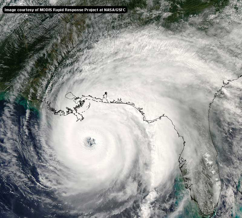
Before I mention the other storms just wanted to say that my heart goes out to the people in SW Fla affected by . Been watching the video, and it reminded me of the aftermath of Andrew, which I saw firsthand.
Danielle just upgraded to a hurricane, but has fish written all over her., Earl is the one to watch, seems to be getting organized, looks like a western GOM storm unless a sharp trough picks him up., we'll see how it plays out in the next few days. Also, that wave train in Africa looks really scary., heading for a real active time the next 4-6 weeks., wasn't it just a couple of weeks ago some of us here were talking about the quiet time?, how fast things change!

TG
|
Steve
Senior Storm Chaser

Reged:
Posts: 1063
Loc: Metairie, LA
|
|
Jamie,
The usually goes way negative if there is/are developing cyclone(s) in the WPAC. A negative over the long haul usually portends El Nino. It can signify blocking or amplification in the US 15ish days down the road. This can help with the idea of whether or not the eastern US will show trof conditions or just a flatter flow across. Depending on other variables, this can help inidicate whether or not the Gulf or East Coast is at risk at a given time. It doesn't portend storms on this side of the ocean, but it can help with paths. The NAO breaking negative is one of the better signals (in non El Nino years) of a coming burst of tropical activity.
Steve
--------------------
MF'n Super Bowl Champions
|
StormLover
Weather Watcher
Reged:
Posts: 32
|
|
Seems like we are in a pattern similar to the 1950s when many strong hurricanes formed and threatened the mainland US. Anyone here think that later on the will upgrade to a Cat 5 like they recently did with Andrew? The scenes of total devestation must have required near-Cat 5 windspeeds.
|
JimAnderson
Registered User
Reged:
Posts: 9
Loc: Fort Monroe Virginia
|
|
Guys,
Often, when looking at the various storms, someone will mention T numbers and/or numbers. Could someone post a link to a glossary or definition?
You all have been truely fascinating during . I have in-laws in N. Fort Myers who were debating going to their trailer parks shelter, but based upon what I saw on here and the site, when my wife talked to them about 1pm yesterday, she was able to convince them to get to shelter. THANKS!
Haven't heard from them yet, but figure it is probably because LEE county is still out of electricity/telephone service.
Jim
|
Jamiewx
Storm Tracker

Reged:
Posts: 371
Loc: Orlando, Florida
|
|
scary how the 12Z turns Earl to the North toward FL panhandle, but i guess models will be flip floping, and we will have to see if any trends develop or whether other models come into agreement with it. 18Z takes the system closer to the Yucatan, will be interesting to see where the models take Earl over the next couple of days.
|
danielw
Moderator

Reged:
Posts: 3525
Loc: Hattiesburg,MS (31.3N 89.3W)
|
|
Here is a chart with the T numbers and classes.
Pressures are different this year. A little higher than the chart says. Maybe one of the more meteorology inclined here on the board can explain it.
http://www.ssd.noaa.gov/PS/TROP/CI-chart.html
Edited by danielw (Sun Aug 15 2004 03:30 AM)
|
LoisCane
Veteran Storm Chaser

Reged:
Posts: 1236
Loc: South Florida
|
|
okay...for a few reasons that i don't want to say yet because im not sure of..i wouldnt slam the door on her getting further west than a storm would normally at that lat this far out being a hurricane
most likely will curve too fast to be a problem but still have to watch how things play out in the mid atlantic in 's wake
as for earl.. a lot to think on
heard dolphins made a big donation to victims in SW florida..
.. wayne made 1 million dollars donation.. nice, not his biggest fan, but nice
hopefully money will be raised for the people who need it most out there
--------------------
http://hurricaneharbor.blogspot.com/
|
LoisCane
Veteran Storm Chaser

Reged:
Posts: 1236
Loc: South Florida
|
|
i think the point is that unless im wrong we are not in a wet phase and all this is going on...can u imagine when the wet phase gets into the basin
--------------------
http://hurricaneharbor.blogspot.com/
|


 Threaded


