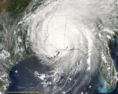
Hurricane Fredrick 1979
Weather Guru

Reged: Sat
Posts: 116
Loc: Mobile,Alabama
|
|
I ran the models early this morning and the model had already picked up on this bringing it to the NGOM in 120h. None of the other models had picked up on it. I will check them out later today.
|
doug
Weather Analyst
Reged: Mon
Posts: 1006
Loc: parrish,fl
|
|
ACTUALLY THE LOOK OF THE CARRRIBEAN FEATURE IS IMPROVED THIS AFTERNOON. IT IS DEFINITELY UNDER A BUILDING UPPER RIDGE AND THERE IS A SURFACE TROUGH. WHILE I CERTAINLY DEFER TO THE EXPERTS, THE VIEWS FROM SPACE DON'T CONFIRM ANY MOMENTUM INTO CENTRAL AMERICA AS REFERRENCED IN THAT DISCUSSION.
LETS SEE HOW IT LOOKS TOMORROW. IF IT IS STILL IMPROVING AND IS OFF SHORE THEN I THINK THE FORECASTERS WILL HAVE TO REVISIT THIS THING.
--------------------
doug
|
Tazmanian93
Weather Master

Reged: Sun
Posts: 495
Loc: Tampa
|
|
Right there w/ you, check my 8:46am EST. Even now is consistent w/ this morning. How far off from the 1996 Bertha Path would the CV storm be? Nevermind, answered my own curiosity http://www.atmos.umd.edu/~stevenb/hurr/96/bertha/bertha_v2.gif
Edited by Tazmanian93 (Thu Jun 30 2005 04:36 PM)
|
danielw
Moderator

Reged: Wed
Posts: 3525
Loc: Hattiesburg,MS (31.3N 89.3W)
|
|
SW Caribbean system has gotten the attention of .
Click on 51E.TCSP-EAST
http://www.nrlmry.navy.mil/tc-bin/tc_hom...mp;STYLE=tables
As long as system is in the Caribbean, with a slight chance of moving toward the NW Caribbean and GOM.
We should probably keep the posts here.
If it should cross over to the Pacific, then posts would go in the " Other Basins" forum.
Edited by danielw (Thu Jun 30 2005 04:57 PM)
|
Tazmanian93
Weather Master

Reged: Sun
Posts: 495
Loc: Tampa
|
|
I should say it would http://weather.msfc.nasa.gov/GOES/GOES17452005181d72vAv.jpg
Good shot of system from 1:45 PM EDT this afternoon.
When it was just starting to get attention.~danielw
Edited by danielw (Thu Jun 30 2005 05:14 PM)
|
Brad in Miami
Storm Tracker
Reged: Wed
Posts: 365
|
|
Why is the Caribbean system listed as an E. Pac invest on ? Because the predicts it will move into the E. Pac, or is that an error? I've never seen that before, focusing on a system on one side of Central America and listing it as an invest for the other side.
|
danielw
Moderator

Reged: Wed
Posts: 3525
Loc: Hattiesburg,MS (31.3N 89.3W)
|
|
If you'll go back to post number 37702. It's on the bottom of the previous page.
I posted an excerpt of a forecast discussion there.
They give a little better reasoning to the 51E classification.
Edited by danielw (Thu Jun 30 2005 05:19 PM)
|
Benjamin
Unregistered
|
|
In regards to the Caribbean feature, I was impressed by the eye-like feature that was seen for about 4 hours earlier today on both visible and infrared satellite. I was wondering if Clark or someone else might know how common it is for a system of such little strength to form an eye-like feature especially in the initial phases of development.
|
Brad in Miami
Storm Tracker
Reged: Wed
Posts: 365
|
|
Thanks for the post Daniel. But I'm still a little unclear on this. The relevant part of the post you directed me to just says, if I'm reading it right, that the is predicted to move westward. I understand that, and that the predicts that the disturbance, or at least a part of it, will move westward. But my question about classifications still is there.
By now I realize the answer to the question pretty much has to be that yes, will classify an invest as an EPAC one even though it's in the Atlantic basin, as long it's predicted to move westward; likely would've corrected any error on the site by now. But I just never have seen that; has that happened before that anyone knows of?
|
danielw
Moderator

Reged: Wed
Posts: 3525
Loc: Hattiesburg,MS (31.3N 89.3W)
|
|
Quote:
TROPICAL DISCUSSION - INTERNATIONAL DESKS
NWS HYDROMETEOROLOGICAL PREDICTION CENTER CAMP SPRINGS MD
220 PM EDT THU JUN 30 2005
TUTT LOW FORECAST JUST NORTH OF HONDURAS NEAR 16N 86W AT 24 HRS roughly 18Z Friday WILL MOVE WEST INTO NORTHERN GUATEMALA BY 48 HRS roughly 18Z Saturday AND TURN TO THE NORTHWEST MOVING INTO THE SOUTHERN GULF OF MEXICO NEAR 22N 92W BY 72 HRS roughly Sunday 18Z. I separated this sentence from the next. As I missed the NW turn into the GOM, when I read it. This is consistant with one of the Cyclone Phase Forecast Models from 12Z this morning
THE LOW WILL ADVECT MOISTURE NORTHWARD INTO HISPANIOLA AND PUERTO RICO EARLY IN THE PERIOD AND JAMAICA THROUGH 72 HRS. EXPECT RAINFALL AMOUNTS OF 20-40MM/DAY WITH MAXIMA OF 40-60MM/DAY. AS DRIFTS WEST EXPECT IT TO ENHANCE CONVECTION OVER
NICARAGUA...HONDURAS...BELIZE...GUATEMALA AND SOUTHERN MEXICO. AS THE LOW INTERACTS WITH MOISTURE OVER THIS REGION...EXPECT DAILY RAINFALL OF 15-25MM/DAY WITH MAXIMA OF 40-60MM/DAY MAINLY AFTER 24 HRS.
This is from the Hydrometeorological Center and not the Tropical Prediction Center or . Please use official forecasts for planning and preparation purposes
New Thread~ SW Caribbean. Please post there. Thanks
|
Storm Cooper
User
Reged: Sat
Posts: 1290
Loc: Panama City , FL
|
|
New thread so head on over....
--------------------
Hurricane Season 2017 13/7/1
|


 Threaded


 [Re:
[Re: 


