MikeC
Admin
Reged: Sun
Posts: 4543
Loc: Orlando, FL
|
|
3PM
Dennis has made landfall near or just west of Cienfuegosa, Cuba (the same location as the radar below) and has weakened just a tad, but remains a strong Category 4 storm. New forecast track reasoning and analysis added from Clark Evans in the Met Blogs below.


Original Update
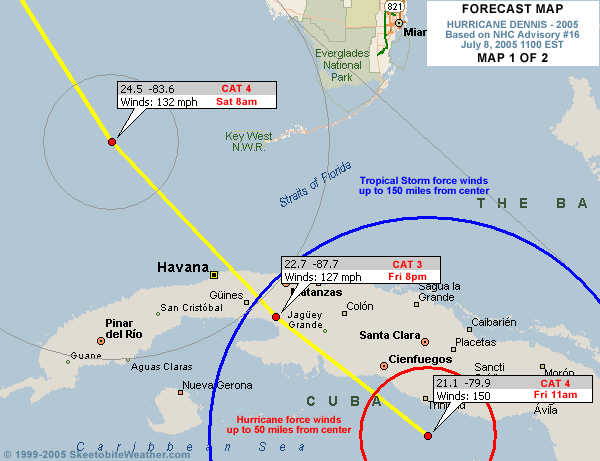
Dennis is a strong Category 4 storm with winds of 150mph as of 11am, and the track takes it to the eastern Gulf and eventually toward the Panhandle to New Orleans regions Sunday night and Monday morning. Radar imagery (below) and reconnaissance observations indicate a potential eyewall replacement cycle to come, though this might be interrupted by time over land this afternoon as it heads for the Gulf of Mexico. The track now takes it west of Key West.
Satellite imagery and upper air observations across the southern United States indicate that the ridge axis may be shrinking north-south with the approach of the storm, with a rather vigorous shortwave trough located along the Texas coast. It is not making much progress eastward at this time, though the southern extent over northern Mexico is building southward. Additional energy currently over the central Plains is headed south towards this shortwave and should help move it east -- how far east and how strong at that point will deternine when exactly makes its turn, as well as how sharp of a turn it will be.
The rest of the Gulf awaits as it crosses Cuba and everyone from Louisiana east to South Florida needs to pay close attention to the overall track of the storm through the day.
 
The following is a mirrored radar image from Cienfuegosa, Cuba, through 10:30am local time as approached, making landfall just west of the radar at 2pm ET. The radar continues to transmit images, but with a couple hours' delay.

Site Note News talkbacks are now in lockdown mode, which means that unregistered users cannot reply.
You can still post in the other forums besides talkbacks. This enables us to moderate a lot better. I hate doing this, but I can see obvious signs of "storm stress" on a few individuals. We'll make it open again as soon as it calms down.
Registration is open for anyone, you can register Using this link. Then you will be able to reply here.
Hopefully this will only last a short time.
Event Related Links
Emergency Management
FloridaDisaster.org - Florida Emergency Management
Monroe County/Florida Keys,
Panhandle Coastal Counties West to East
Escambia County, FL, Santa Rosa, County, Okaloosa County, FL,
Walton County, FL,
Bay County, FL, Gulf County, FL, Franklin County, FL...
StormCarib hurricane reports from observers in the Islands - Jamaican StormCarib Reports
Caribbean Island Weather Reports
Guantanamo Bay, Cuba Radar
Florida Keys Long Range Radar Loop
Tampa Bay, FL Long Range Radar
Miami, FL Long Range Radar
Melbourne, FL Long Range Radar
Tallahassee, FL Long Range Radar
Mobile, AL Long Range Radar
Dennis
High Speed Storm Relative Floater - RAMSDIS ONLINE
Animated Model Plot of
Model Plot Graphic from the South Florida Water Management District of
Dennis Spaghetti Model from boatus
Weather Underground Model Plots for
Quikskat Image of
Color Sat of
Floater Satellite (Visible) of with Storm Track Overlays
Cienfuegosa, Cuba Radar - (Animated)
RAMSDIS high speed visible Floater of
Forecast Discussions for (Show All Locations):
Tampa. Mobile Bay,
New Orleans, Key West, Tallahassee.
Melbourne
|
Liz
Weather Watcher

Reged: Mon
Posts: 31
Loc: Daytona Beach, Florida
|
|
Really appreciate that radar of Cuba. He is really BIG!
Liz
|
trinibaje
Weather Guru
Reged: Tue
Posts: 136
Loc: MIAMI, FLORIDA
|
|
My prayers are with the Cuban people being affected.. He is huge and dangerous 
--------------------
-----------MY 2005 PREDICTION--------
15/10/5
|
Katie
Weather Guru

Reged: Tue
Posts: 167
Loc: Winter Haven, FL
|
|
Wow, he looks pretty darn impressive. I feel sorry for everyone down there.
|
bn765
Weather Hobbyist
Reged: Fri
Posts: 60
|
|
Could be lookin at a Cat 5 very soon
|
pcola
Storm Tracker

Reged: Wed
Posts: 344
Loc: pensacola/gulf breeze
|
|
150 mph at the 11 am.
--------------------
Erin 95 , Opal 95, Ivan 04, Dennis 05, and that's enough!!!!
|
Liz
Weather Watcher
Reged: Mon
Posts: 31
Loc: Daytona Beach, Florida
|
|
I agree....My prayers go out to those there  Where do they evacuate to? Where do they evacuate to?
|
Droop31
Weather Watcher
Reged: Wed
Posts: 32
Loc: Pensacola
|
|
Yea I feel sorry for the folks in Cuba. Im a nervous wreck right now, Im praying this thing weakens some over Cuba. I dont want to deal with a cat4. Anyone see some reasons that would make it weaken in the gulf?
|
doug
Weather Analyst
Reged: Mon
Posts: 1006
Loc: parrish,fl
|
|
Radar confirms motion toward eventual exit between 81-82w, that is what I'm looking for...still think the generalized motion of the moisture off the coast from that point ahead of the system is NNW...all the way to the panhandle.
--------------------
doug
|
gavsie
Verified CFHC User

Reged: Sat
Posts: 18
Loc: Seminole Fl
|
|
Is there a new track out for ?
|
Prospero
Storm Tracker

Reged: Fri
Posts: 267
Loc: Gulfport, FL
|
|
Here in the Tampa Bay area you can "feel" something in the air. Whenever a storm approaches there is something different about how the air feels. I imagine wild animals and birds are getting a bit stirred up. Last night I watch a dolphin swimming just feet away from the shoreline off the Courtney Campbell Causeway. I bet the trees can feel it.
If I were in the mountains of Colorado where I lived for 20 years, I'd be preparing for several feet of snow. It is the same "feel" in the air.
Somethin's happening out there...
--------------------
Gulfport Florida Webcam - Gulfport Florida Weather Station - Clearwater Beach Cams
|
trinibaje
Weather Guru
Reged: Tue
Posts: 136
Loc: MIAMI, FLORIDA
|
|
Quote:
I agree....My prayers go out to those there Where do they evacuate to?
I don't know about Cuba, but i know for many islands there are hurricane shelters... now how storm worthy are they? That's a whole different issue.
--------------------
-----------MY 2005 PREDICTION--------
15/10/5
|
PFSThunder
Weather Watcher

Reged: Wed
Posts: 38
Loc: Charleston, SC
|
|
The eye is now visible on the Key West Long range radar loop.
http://www.srh.noaa.gov/ridge/byx_N0Z_lp.html
--------------------
Go Boilermakers
|
Clark
Meteorologist
Reged: Wed
Posts: 1710
Loc:
|
|
New track as of 11a is a little to the right of the previous track per the discussion, but by the thinnest of margins. Best I can tell, it has landfall near the same point as , albeit at a different angle. We'll see what the 12Z model runs bring with the system.
--------------------
Current Tropical Model Output Plots
(or view them on the main page for any active Atlantic storms!)
|
Ricreig
User

Reged: Sat
Posts: 431
Loc: Orlando, Fl
|
|
Quote:
Dennis is a strong Category 4 storm with 150MPH winds, and a unbelievably low barometric pressure of 938 mb... for July.. and the track takes it to the eastern Gulf and eventually toward the Panhandle to New Orleans regions Sunday night and Monday morning.
This radar shows a track that will take the storm to about 24N 84W. The track should miss Key West far enough West of Key West to spare them the brunt of the storm but due to the size, probably will feel some hurricane force winds. On that track also, looking at the map superimposed on the radar display, it would seem to confirm that the rest of South Florida whould not be affected directly, Thankfully. Once it does get to about 85W, the peninsula cand start to breathe easier unless starts to move NNE which doesn't seem likely at the moment. Trends are friends but my thought is that there are VERY few friends you would trust your life to. So, stay alert. I agree with Mike on this one, Louisiana is NOT out of the running for this booby-prize but with the weakening ridge to the East, I wouldn't bet against a landfall in the panhandle of Florida either. Wherever it goes, someone is going to be hurt, especially if unprepared for a storm of this magnitude. Good luck to all in the path.
--------------------
Richard
A forecast is NOT a promise!
Edited by Ricreig (Fri Jul 08 2005 11:00 AM)
|
AgentB
Weather Guru

Reged: Fri
Posts: 188
Loc: Winter Park, FL
|
|
Still looking NW, and has picked up just a bit to 15mph. Hurricane force winds extend outward to 50mi and t.s. force winds outward to 160mi. Definitely saying a prayer for the people of Cuba, and the other Carribbean islands. I'll be watching to see where crosses Cuba. Right now the forecast calls for him to come onshore just east of Playa Giron. I'm curious as to whether or not that comes to fruition. I've also been thinking a lot of the people I knew when I lived in Key West. Things aren't looking too great for them right now.
--------------------
Check the Surf
|
ftlaudbob
Storm Chaser

Reged: Tue
Posts: 828
Loc: Valladolid,Mx
|
|
Quote:
Is there a new track out for ?
That is what I would like to know.
--------------------
Survived: 10 hurricanes in Rhode Island,Florida and the Yucatan of Mexico .
|
AgentB
Weather Guru
Reged: Fri
Posts: 188
Loc: Winter Park, FL
|
|
Quote:
Quote:
Is there a new track out for ?
That is what I would like to know.
I haven't seen one from the . However, if you click on "coordinates" on the left of the screen, then click on "plot" by the storm name, you can loop the different models. Clicking "last" before you click "play" however gives you the most up-to-date frame of the models(I think).
--------------------
Check the Surf
|
Lake Toho - Kissimmee
Storm Tracker

Reged: Tue
Posts: 317
Loc: Kissimmee, Florida on Lake Toh...
|
|
11 AM is out.. Track edged slightly to East..
--------------------
Dream like you will live forever.. Live like there is no tommorow.. Darwin Rules !!
|
Ricreig
User
Reged: Sat
Posts: 431
Loc: Orlando, Fl
|
|
Quote:
Quote:
Is there a new track out for ?
That is what I would like to know.
Take a look at
http://www.nrlmry.navy.mil/tc_pages/ATL/04L.DENNIS/ssmi/gif/full/Latest.html
--------------------
Richard
A forecast is NOT a promise!
|


 Threaded