MikeC
Admin
Reged:
Posts: 4544
Loc: Orlando, FL
|
|
7:05AM Update

Dennis is back up to Category 2, unfortunately, even with the drop to Category 1 this morning, core did not completely collapse, giving it the opportunity to restrengthen. In fact, recon is reporting that the eye wall is closed again all around.
I suspect it will regain its major hurricane status sometime today.
The radar for the Panhandle, located at Eglin Air Force Base (KEVX), has had a motor failure, keepiing that off. There is a rush to replace it, so hopefully we'll have that to look at and study before the day is out.

6:45AM Update
Dennis is back to a Category 1, weakening even more than I thought it wuold over Cuba. Although bad for Cuba, this is better news for us. Depending on how much the eye collapsed, storms tend to have a more difficult time reforming after such a drop in windspeed. retained a lot of its structure though, so strengthening is still possible. I"d still expect a major hurricane at landfall, but not a Category 4.
The other good news is that it tracked further west, being further west away from Key West, so they won't receive the full brunt of the system. Much of the Florida Peninsula will get feeder bands today, and it will generally be a bad day to be out. There exists the potential for nasty dounbursts, and short lived tornadoes.
I'm slightly relieved this morning because of those two things, but I'm not sure how much it will matter for the Gulf coast. Forecast track is still good, in my opinion.
Many people ask about how made a "ight turn" into Central Florida. But you have to remember it was still well within the cone of error, and was predicted to make a west coast Florida landfall. has neither.
Beyond , the wave in the central Atlantic is starting to get tis act together, and may become a depression before the weekend is out.
Original Update
Dennis is back down to a Category 2 storm, after spending a bit more time over Cuba than originally expected. It is forecast to regain strength back into a Category 3 storm.
 
The Florida keys will see winds pick up more and more tonight. But the storm is staying far enough west to not have a direct landfall there.

The future track still puts it up toward the western panhandle, with the potential area from Louisiana to the Panhandle of Florida.
Tomorrow the Florida peninsula will see feeder bands, possible tornadoes, and short but heavy bands of rain move through along with being a general breezy day. Tropical storm force winds may be confined to the extreme west coast of Central Florida.
More tomorrow...
I'm looking for good related links to place on the front page; this includes good images, radar, satellite, streaming audio,video, emergency information, etc. Reply and let us know.
Site Note News talkbacks are now in lockdown mode, which means that unregistered users cannot reply.
You can still post in the other forums besides talkbacks. This enables us to moderate a lot better. I hate doing this, but I can see obvious signs of "storm stress" on a few individuals. We'll make it open again as soon as it calms down.
Registration is open for anyone, you can register Using this link. Then you will be able to reply here.
Hopefully this will only last a short time.
Event Related Links
Emergency Management
Gulf Coast Storm Alert Network
FloridaDisaster.org - Florida Emergency Management
Monroe County/Florida Keys,
Panhandle Coastal Counties West to East
Escambia County, FL, Santa Rosa, County, Okaloosa County, FL,
Walton County, FL,
Bay County, FL, Gulf County, FL, Franklin County, FL
Mississippi Emergency Management Agency (MEMA)
http://www.msema.org/index.htm
StormCarib hurricane reports from observers in the Islands - Jamaican StormCarib Reports
Caribbean Island Weather Reports
Guantanamo Bay, Cuba Radar
Florida Keys Long Range Radar Loop
Tampa Bay, FL Long Range Radar
Miami, FL Long Range Radar
Melbourne, FL Long Range Radar
Tallahassee, FL Long Range Radar
Mobile, AL Long Range Radar
Casablanca, Cuba Radar
Dennis
High Speed Storm Relative Floater - RAMSDIS ONLINE
Animated Model Plot of
Model Plot Graphic from the South Florida Water Management District of
Dennis Spaghetti Model from boatus
Weather Underground Model Plots for
Quikskat Image of
Color Sat of
Floater Satellite (Visible) of with Storm Track Overlays
Cienfuegosa, Cuba Radar - (Animated)
RAMSDIS high speed visible Floater of
Webcams, Video, Audio
Mark Sudduth's at coastal Alabama again ready to move east or west, he has a mobile observation tower he'll be leaving along the coast when arrives - Hurricane Trak/Mark Suddth Car & Tower Cam
Suncam.tv's collection of cam's and Mobile (not the city) cams - Suncam.tv's Moble Car Cam
Hurricane City and Jim Williams do audio shows nightly around 8PM
Joseph Johnston's Mobile Bay Webcam
Key West Webcams
New Orleans webcams
Radio Habana, Cuba
Forecast Discussions for (Show All Locations):
Tampa, Mobile Bay,
New Orleans, Key West, Tallahassee.
Melbourne
|
stormchazer
Storm Tracker

Reged:
Posts: 315
Loc: Central Florida
|
|
Well folks, I will leave you to watching tonight. I will say a little prayer for those west of the Big Bend with all friends and a few relatives close in mind.
We shall see what the morning brings but the seems to have it pegged. FL/AL/MS borders get ready because it appears an unwelcome visitor is approaching.
--------------------
Jara
*************************************************************
|
tpratch
Moderator

Reged:
Posts: 339
Loc: Maryland
|
|
New topic, easier to show the filled request. It's borderline on-topic because all of the hurricane advisories are in CAPS.
I put together a quick and dirty converter for everyone. Simply copy and paste the text you want de-capsimahfied into that text area and click the shiny button.
http://www.ten15.net/convert.html
Cheers,
--Tom
*if too off-topic, kill this post - just trying to be helpful and I'm heading to bed.
|
MarcoResi
Weather Watcher

Reged:
Posts: 33
Loc:
|
|
Off to bed now Praying for yall up north, remember if in doubt get out!!
|
dolfinatic
Weather Guru
Reged:
Posts: 129
Loc: St. Petersburg, Fl
|
|
here is water vapor sat for GOM. Interesting to see that trough beginning to dig south and east a bit faster now. hmmm. http://www.ssd.noaa.gov/PS/TROP/DATA/RT/gmex-wv-loop.html
|
Margie
Senior Storm Chaser

Reged:
Posts: 1191
Loc: Twin Cities
|
|
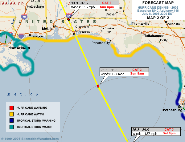
Discussion 18 mentions Pascagoula for the first time. I am hoping that tomorrow evening I am not seeing another track like . I remembered how they kept saying it was going to turn east and turn east and it didn't. didn't turn east until the very last couple hours, so Pascagoula dodged the bullet then.
"The and have shifted
to the right of their previous forecasts...while the UKMET remains
to the left of center of the guidance envelope. Consensus models
remain clustered around a landfall between Pascagoula and ft.
Walton Beach. The forecast track is shifted a little to the left
of the previous track...to match the initial position and motion in
the first 24 hr and to be a little closer to the consensus models
from 24-48 hr."
--------------------
Katrina's Surge: http://www.wunderground.com/hurricane/Katrinas_surge_contents.asp
|
ftlaudbob
Storm Chaser

Reged:
Posts: 828
Loc: Valladolid,Mx
|
|
I just came from the beach,and I am just amazed at mother nature.The eye is so far away from here,yet the waves are huge ,the wind on the beach is a steady.12,000 without power in Broward,15,000 in Miami-Dade.Highest gust here in Broward was 50mph.I had to dodge parts of palm trees to and from the beach.Just the fact the eye is so far from here and yet I am seeing this,Amazing.
--------------------
Survived: 10 hurricanes in Rhode Island,Florida and the Yucatan of Mexico .
|
hurricane_run
Storm Tracker

Reged:
Posts: 366
Loc: USA
|
|
that is amazing.
|
Storm Hunter
Veteran Storm Chaser

Reged:
Posts: 1370
Loc: Panama City Beach, Fl.
|
|
here is hrd from 130 UTC
interesting as storm weakened
ftp://ftp.aoml.noaa.gov/pub/hrd/hwind/2005/al04.2005/0709/0130/col02deg.png
eyewall is exiting coast now... almost halfway
recon is very close to eyewall..... would expect within 15-30mins first report from center
--------------------
www.Stormhunter7.com ***see my flight into Hurricane Ike ***
Wx Data: KFLPANAM23 / CW8771
2012== 23/10/9/5 sys/strms/hurr/majh
Edited by Storm Hunter (Sat Jul 09 2005 03:44 AM)
|
FlaMommy
Storm Tracker

Reged:
Posts: 225
Loc: Tampa(Riverview), Florida
|
|
hey bob...im curious but do u still stick by your prediction?....im not going on your prediction imjust curious thats all...thanks
--------------------
"Haven't thought of a witty one lately"
|
hurricane_run
Storm Tracker
Reged:
Posts: 366
Loc: USA
|
|
southern fl is getting hit with some heavy bands. anyone have conditions from there.
|
Justin in Miami
Storm Tracker
Reged:
Posts: 269
Loc: Ft. Lauderdale, Florida
|
|
Yes. Very squally weather...calm one moment...then boom 30-45mph winds and horizontal rain. Very cool..and a little eerie considering the distance we are from the center. Very humid tropical airmass.
|
hurricane_run
Storm Tracker
Reged:
Posts: 366
Loc: USA
|
|
the eye is exiting the coast. key west radar
|
Justin in Miami
Storm Tracker
Reged:
Posts: 269
Loc: Ft. Lauderdale, Florida
|
|
and another thing...dogs are a little on edge tonight...during ...and Jeanne last year no problems...but tonight they are noticeably different....not that this means much lol
|
Justin in Miami
Storm Tracker
Reged:
Posts: 269
Loc: Ft. Lauderdale, Florida
|
|
looks like it is joggin a little to the north off the coast.
|
lee haycook
Registered User

Reged:
Posts: 4
Loc: Southwest Florida
|
|
I'm in Cape Coral, we are having one storm after another, right now a band has just passed thru very breezy & wet am showing wind at about 10 on the weatherbug reading about a mile away from me.
--------------------
Just once I wish someone would call me "Sir" without adding "you're making a scene"
|
ftlaudbob
Storm Chaser
Reged:
Posts: 828
Loc: Valladolid,Mx
|
|
Quote:
hey bob...im curious but do u still stick by your prediction?....im not going on your prediction imjust curious thats all...thanks
Well,if Key West gets hurricane force winds I may save face.But I think South Florida most likely will not get a derect hit.Are biggest threat here now is tornados.We are under so many watches and warnings now,I can't keep track.Let's see......flash flood warning,tornado watch,high wind warning, severe thunder storm warning and watch. 
--------------------
Survived: 10 hurricanes in Rhode Island,Florida and the Yucatan of Mexico .
|
Justin in Miami
Storm Tracker
Reged:
Posts: 269
Loc: Ft. Lauderdale, Florida
|
|
another nasty band about to go through Broward
|
FlaMommy
Storm Tracker
Reged:
Posts: 225
Loc: Tampa(Riverview), Florida
|
|
we havent had any bands here in tampa since about 6 or so....so i guess were doing pretty good so far....be safe everyone
--------------------
"Haven't thought of a witty one lately"
|
BeachBum
Weather Watcher

Reged:
Posts: 29
Loc: The Space Coast
|
|
Considering what Cindy did to Atlanta, I don't think heading to Montgomery is such a great idea. If I-10 was moving, I would go to Jacksonville.
For those between the Gulf and Choctawatchee Bay, any place will be better.
For newbies in Pensacola, ask your neighbors how the building/area did during . Solid structures north of I-10 should provide good shelter. I did see some damage in that area to older buildings.
Note: I am a coward. I left early for both and Jeanne.
--------------------
From Brevard's Barrier Island
28°08'56"N; 80°35'11"W
|


 Threaded