MikeC
Admin
Reged: Sun
Posts: 4543
Loc: Orlando, FL
|
|
Clark, Ed, et all will be taking over this weekend, which is great considering the doubts I have with Irene too. Recon hopefully will reduce some of the anxiety over what the track may do.
|
Old Sailor
Storm Tracker

Reged: Mon
Posts: 293
Loc: Florida
|
|
Is it me or has Irene lost a lot of convection on the last few frames , maybe reason for jog to west some, See what Recon finds.
Dave
|
Ed in Va
Weather Master
Reged: Fri
Posts: 489
Loc:
|
|
It has...now the small orange dot left conincides more with the 11:00 reported positon, although somewhat west of it.
http://www.ssd.noaa.gov/PS/TROP/DATA/RT/float2-ir4-loop.html
--------------------
Survived Carol and Edna '54 in Maine. Guess this kind of dates me!
|
rmbjoe1954
Weather Master

Reged: Tue
Posts: 427
Loc: Port Saint Lucie, Florida, USA
|
|
I see the genral movement WNW with a 'westward' bias.
It's hard when you can't see the center of circulation.
--------------------
________2024 Forecast: 28/14/8________
There is little chance that meteorologists can solve the mysteries of weather until they gain an understanding of the mutual attraction of rain and weekends. ~Arnot Sheppard
|
NewWatcher
Storm Tracker

Reged: Wed
Posts: 388
Loc: Port Orange, FL
|
|
IF she is moving NW, and I dont think she is, then she isnt taking the convection with her. Looks to be weakening to me
--------------------
Pam in Volusia County
According to Colleen A ... "I AM A HURRICANE FREAK"
2007 Predictions 16/9/6
|
LoisCane
Veteran Storm Chaser

Reged: Fri
Posts: 1236
Loc: South Florida
|
|
http://64.233.187.104/search?q=cache:5A-...oater&hl=en
looks west to me and looking at wv loop don't see how with all those ULL's pulling it and the capping to the north.. how it will go nnw anytime soon, let alone nw
my unprofessional opinon..this thing does more than flirt with land
you look and tell me
--------------------
http://hurricaneharbor.blogspot.com/
|
NewWatcher
Storm Tracker

Reged: Wed
Posts: 388
Loc: Port Orange, FL
|
|
I think it will make more of a turn to the north, if it is going to, when the center passes 70W
--------------------
Pam in Volusia County
According to Colleen A ... "I AM A HURRICANE FREAK"
2007 Predictions 16/9/6
|
LoisCane
Veteran Storm Chaser

Reged: Fri
Posts: 1236
Loc: South Florida
|
|
http://hurricane.accuweather.com/hurrica...amp;region=HATL
--------------------
http://hurricaneharbor.blogspot.com/
|
Frank P
Veteran Storm Chaser
Reged: Mon
Posts: 1299
|
|
Interesting comments... WNW or NW??? I think its wobbleing between the two, however, on the latest vis loop it still looks right on track and hints of going back from the WNW wobble to perhaps a NW motion.. you be the judge.... nice banding features also showing up on the last few frames....
http://www.ssd.noaa.gov/PS/TROP/DATA/RT/float2-vis-loop.html
|
The Force 2005
Storm Tracker
Reged: Fri
Posts: 299
Loc: Philadelphia
|
|
If you watch the loop from Accuweather that you posted, watch where Irene starts and finishes. She starts at aroun62.5W and travels all the way to about 70W without ever getting above 30N. Seems to me a westerly track vice N-NW as being reported by the . Any thoughts!!!
|
scottsvb
Weather Master
Reged: Mon
Posts: 1184
Loc: fl
|
|
Well everything is still on the forecasted path. Finally last night everything has come into place as predicted. Her midlevel center finally came down completely to the surface and is moving near 305dg ( on a 12 hour basis) with a current bend to 290dg. I expected the old LLC or vortex to move out of the whole system today and slowly head towards the bahamas, infact if you look at the visible a lone vortex has moved out this morning and is near 25.5N and 71.5W. Its just a LLV that was originally the center. I dont expect anything from this cause its soo small and weak.
Anyways Irene should slow some feeling the ridge but I dont expect a meander that the predicts. She is caught in the weakness of the ridge starting tomorrow and eventually get pulled N and NE as a shortwave trough moves across the US.Canadian border early next week.
On a side note....the again outperformed them all so far. The models including the have been seeing a low form over the SW Carribean in a couple days and move NW towards Nicaragua and Honduras. Not biting on this yet but its a wait and see. It will probably go into central america, if it does go into the NW carribean, it will be monitored for having a chance to get into the gulf due to the upper troughiness in the gulf.
scottsvb
Edited by scottsvb (Fri Aug 12 2005 12:51 PM)
|
NONAME
Weather Guru

Reged: Sun
Posts: 136
|
|
Recon leaves in a 1h and 15 minutes and hope they find some good iformation to help the models out also the wave in the central atlatic look like it get better organized what would this wave possibley is there more off a chance if this devlops for it to hit land because it is so far south or could it possible follow a weakness left by irene if there even is one.
|
LoisCane
Veteran Storm Chaser

Reged: Fri
Posts: 1236
Loc: South Florida
|
|
Scott I would love to agree with you. I've looked at every water vapor I can find and in the last six hours or so that ridge has grown strong and is very horizontal, Irene is way tucked under it and I don't see any weakness currently.
Know there is one forecast but she is moving just below what seems to be a strengthening ridge.
Maybe when the Gulfstream Jet gets some good hard data on the strength of the high we will know more later this afternoon.
--------------------
http://hurricaneharbor.blogspot.com/
|
LoisCane
Veteran Storm Chaser

Reged: Fri
Posts: 1236
Loc: South Florida
|
|
yes, its looking good
see that
--------------------
http://hurricaneharbor.blogspot.com/
|
Reaper
Weather Watcher

Reged: Wed
Posts: 45
Loc: Lake Placid, Fla
|
|
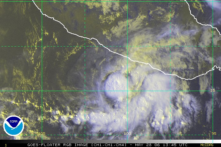
That's not IRENE.
That's FERNANDA in the Pacific
Here's IRENE
http://www.ssd.noaa.gov/PS/TROP/DATA/RT/float2-vis-loop.html
Edited by Reaper (Fri Aug 12 2005 12:51 PM)
|
LoisCane
Veteran Storm Chaser

Reged: Fri
Posts: 1236
Loc: South Florida
|
|
actually thought fernanda looked better than that...
been noticing correlations tho in them
either way.. looked on IR posted above.. and Irene is moving a west-wnw motion right now.. not worried on now.. worried on tomorrow
--------------------
http://hurricaneharbor.blogspot.com/
|
damejune2
Storm Tracker

Reged: Sat
Posts: 237
Loc: Torrington, CT
|
|
I don't know about you or anyone else, but i usually don't worry too much about the tropical waves until they get 1)named 2)closer to the caribbean. I know things will change, but so far a lot of whats been coming of Africa starts off good but then peters out....personally i'd like to see it stay that way but we all know that won't happen.
--------------------
Gloria 1985 (Eye passed over my house in...get this...northwestern CT!)
|
Frank P
Veteran Storm Chaser
Reged: Mon
Posts: 1299
|
|
my opinion as of the moment is that Its not going WNW it going NW... go to this GOES link, click on animinate and 8 image loop, click on the est center of Irene and put in loop... to me its going NW
http://wwwghcc.msfc.nasa.gov/GOES/goeseastconus.html
|
Frank P
Veteran Storm Chaser
Reged: Mon
Posts: 1299
|
|
Irene is right on the track... take another look at the visible floater, add the forcast track plots... you'll see what I've been talking about, if not , I'd like a visual you're looking at that shows differenly...
http://www.ssd.noaa.gov/PS/TROP/DATA/RT/float2-vis-loop.html
|
The Force 2005
Storm Tracker
Reged: Fri
Posts: 299
Loc: Philadelphia
|
|
Frank,
On the last feature of that loop, it appears to me an eye is trying to form or has already formed. What do you think?
|


 Threaded


 [Re:
[Re: 


