MikeC
Admin
Reged: Sun
Posts: 4543
Loc: Orlando, FL
|
|
8AM 11.Aug.2005
Irene is struggling due to a lot of dry air out in front of it, but maintaining itself. It may strengthen, very slowly, or not much at all today because of the dry air.

The most likely scenario stilll is that Irene will recurve out to sea before approaching land, however anyone in the cone should be watching it. Judging by current trends it should past just east of the Carolina and then recurve out. If it slides further west it would touch the outher banks.

For Florida, the only possible affect I can see with this track is maybe a slight reduction in the amount of afternoon thunderstorms as the storm moves west. (Irene needs all the moisture it can get in the current environment it has). Chances for anything more than that are too low to really mention.
Bottom line, if you are in the Cone area, keep watching it closely. The timing of the move to the north is everything once again. Dry air will keep it from strengthening until it reaches 70W or so.
11PM
Irene is once again a tropical storm, but barely. The track was adjusted to the north somewhat tonight, and I'm seeing some hope that a weakness in the ridge is developing, keeping Floirda out of the cone, and giving the out to sea scenario a boost. However, anywhere in the cone should be watching the system. Especially North Carolina.
It all depends on how the ridge holds up or not. I'm still leaning toward... or perhaps hoping.. for the out to sea scenario, but very close to the Carolinas.
Original Update
Tropical Depression Irene has remained weak, and I'm beginning to think it will stay weak as a depression or a minimal to mid-strength tropical storm for the next few days.

Dry air will also keep it in check from gaining strength too rapidly. The center still remains difficult to pinpoint.

Irene's future track depends a lot on the ridge and any situation which might weaken it, and cause it to move more northward. Today it's moving a little more toward the north than it was yesterday, which is good news for Florida, and more interesting for the Carolinas. The potential to move out to sea is still possible and remains the most likely, but even if so it may still make a close approach to the Carolinas.
Alternatively the ridge builds even more and forces it further west, probably keeping the storm weaker a bit longer. This increases the chances for a bit further south. It's likely Florida will enter into the Cone of error tomorrow for the 5 day period, but the highest probability will remain for the Carolinas.
Models have been a bit right (or north) biased the last two or three days or so, I expect more of a westward trend, which will force everyone to watch the system. Assuming Irene can survive and the ridging builds, we will probably know better in about 2-3 days.
Bottom line, it needs to be watched, especially for the Carolinas.
There are a few more waves over Africa that will require a long term eye soon as well.
Event Related Links
StormCarib hurricane reports from observers in the Islands
Caribbean Island Weather Reports
Color Sat of Gulf
RAMSDIS high speed visible Floater of Storms
Irene
Animated Model Plot of Irene
Satellite Image of Irene with Storm Track Overlays
Infrared color Satellite Image of Irene with Storm track Overlays
Model Plot of Irene (Graphic from the South Florida Water Management District)
Quikscat image of Irene
Weather Underground model plots of Irene
Irene Sphagetti Plot from BoatUS
|
craigm
Storm Tracker

Reged: Wed
Posts: 327
Loc: Palm City, Florida
|
|
This vapor image is about 30 minutes old. Still no definite LLC center but banding looks good.
http://www.nrlmry.navy.mil/tc-bin/tc_hom...SUB_PRODUCT=1km
|
MikeC
Admin
Reged: Sun
Posts: 4543
Loc: Orlando, FL
|
|
I forgot to mention, Irene may be a smaller (sized) system, and it therefore might pull a few surprises. Expect the unexpected with it. it's already got me twice.
|
LI Phil
User

Reged: Fri
Posts: 2637
Loc: Long Island (40.7N 73.6W)
|
|
Based On Data:

Edited by MikeC (Wed Aug 10 2005 07:09 PM)
|
craigm
Storm Tracker
Reged: Wed
Posts: 327
Loc: Palm City, Florida
|
|
Mike that vapor image I linked to. What height in the depression is that looking at.
--------------------
Why I'm here:
Weather hobbyist
|
Beaumont, TX
Storm Tracker
Reged: Tue
Posts: 318
|
|
Is it still possible Irene could curve out to sea or is that possibility becoming less likely? Also, the weather channel mentioned something of interest they were watching which looked to be down around South America. Does anyone know what they are talking about?
|
MikeC
Admin
Reged: Sun
Posts: 4543
Loc: Orlando, FL
|
|
Quote:
Is it still possible Irene could curve out to sea or is that possibility becoming less likely? Also, the weather channel mentioned something of interest they were watching which looked to be down around South America. Does anyone know what they are talking about?
Craig, not too sure, Clark would know.
It's still a good possibility, better chance of it to recurve then landfall in florida, for sure. but that's dropping now for more of a Carloina area. We'll just have to wait and see.
|
WX Storm 2005
Verified CFHC User
Reged: Thu
Posts: 14
Loc: Boynton Beach, FL
|
|
I attached a forcast this is not an official forcast and should not be used as such. What do you guys think?
--------------------
Nathan Fairman
Nfairman@adelphia.net
Natedogg3L - Aim
|
rmbjoe1954
Weather Master

Reged: Tue
Posts: 427
Loc: Port Saint Lucie, Florida, USA
|
|
We have to see what impact the ridge has to see if that turn does take affect as you had plotted.
--------------------
________2024 Forecast: 28/14/8________
There is little chance that meteorologists can solve the mysteries of weather until they gain an understanding of the mutual attraction of rain and weekends. ~Arnot Sheppard
|
Kevin
Weather Master

Reged: Fri
Posts: 524
Loc: EC Florida
|
|
That's an interesting forecast. Interesting in the sense that the Georgia coast, historically anyways, doesn't usually see tropical cyclone landfalls from that angle. In fact, Georiga isn't directly impacted by too many tropical cyclones at all. With that in mind, I have a little feeling that Irene's track is going to be one that is less than straightforward.
On another note...Irene's convection seems to be lessening in intensity this evening. Also looks to be moving more westerly at this point.
|
Frank P
Veteran Storm Chaser
Reged: Mon
Posts: 1299
|
|
what I see right now is a system that on IR looks to be a little better organized... last couple of frames shows perhaps the most convection near the center in the past two days as it trys to wrap around the center ... and it also has good outflow on its northern quadrants... also gaining latitude somewhat as it looks to be getting a little more northerly component in its motion, as it should per the ... this is a small system also
http://www.ssd.noaa.gov/PS/TROP/DATA/RT/float2-ir4-loop.html
|
Frank P
Veteran Storm Chaser
Reged: Mon
Posts: 1299
|
|
this is what's amazing on forums like this and makes it so interesting, Kevin sees something entirely different than what I see... not says he right nor wrong, guess we both are looking at different sources and seeing something different...and that's fine by me.. here's the loop that gave me the impression that Irene was getting some northerly component in its motion... moving WNW IMO
http://www.srh.noaa.gov/srh/tropicalwx/satpix/watl_vis_loop.php
|
HanKFranK
User

Reged: Mon
Posts: 1841
Loc: Graniteville, SC
|
|
georgia, huh? well, historically there have been some to come straight in out of the e/se. that section of coastline should get hit every 15-25 yrs, but they've been phenominally lucky for a long time. last major was in 1898. irene will have to get further west without intensifying to threaten ne fl/ga (unless the ridge is progged too far east/too weak)... carolinas esp. nc more likely. that's climo talking... as it gets closer in and we've got a better fix on the ridge evolution/intensity of irene.. both will determine the exact track. i expect the track to slalom rather than stair-step.. once the center gets more well established.
right now convection is finally in a single curved band near the center rather than spotty around the mlc/llc. the two may be stacked right now. the outflow pattern is becoming anticyclonic and shear is not as apparent. irene will probably speed up tomorrow, slow as a shortwave comes by, speed up again, slow again late in the weekend as another shortwave comes by.. and from there it's a headscratcher. some of the models have the western periphery of the ridge weak and take it up near nc... maybe even missing the cape... others have it stronger and have the storm heading for ga/sc. as the ridge waxes and wanes, weakening and rebuidling.. irene should wiggle along its track.. but generally move wnw. i'm pretty sure the intensity forecast is too low... irene will be moving west under a ridge with a favorable outflow pattern... major hurricane in my book. i'm gonna be at the coast sat-mon, so the group i'm with may end up being chased out by hurricane watches. will see.
clark already gave the basic info on how the basin should activate in the next week. i'll add that fernanda in the eastpac is trying to gain company. my thought is that we'll probably be looking at more than one new storm in the next two weeks. considering that it's august 10th that's nothing abnormal. end of the month should have the eastern atlantic cranking.
twc mentioning a system near south america? there's a low-level trough with ridging aloft east of the islands. lots of dry air nearby.. nothing should develop quickly. waves further east getting perkier. nothing like an invest there just yet.
site got kind of messy earlier today while i was in class. want everybody to consider the rules/choice of forum for your posts to keep things running smooth. ideally nobody will have to moderate the forum, but we'll talk things over with folks before taking action against disregard for the rules.
HF 0001z11august
|
Brad in Miami
Storm Tracker
Reged: Wed
Posts: 365
|
|
Ron: I apologize - I was wrong on just about everything I said about that model. I had no idea there was that long of a delay from the time on it till its release and didn't know the doesn't incorporate it into its forecasts.
Clark: Thanks for clearing those things up. Yet again.
|
Old Sailor
Storm Tracker

Reged: Mon
Posts: 293
Loc: Florida
|
|
Frank:
I kind of agree with Irene going WNW and if she gets up to 50mph, you should see a 300 degree track, but time will tell for now .
Dave
|
Kevin
Weather Master
Reged: Fri
Posts: 524
Loc: EC Florida
|
|
Quote:
this is what's amazing on forums like this and makes it so interesting, Kevin sees something entirely different than what I see... not says he right nor wrong, guess we both are looking at different sources and seeing something different...and that's fine by me.. here's the loop that gave me the impression that Irene was getting some northerly component in its motion... moving WNW IMO
http://www.srh.noaa.gov/srh/tropicalwx/satpix/watl_vis_loop.php
I think the difference is in the loops that we are watching. I was watching the motion on the IR section of the storm floater. Perhaps the elongation of the convection from e-w near the center is giving the impression of a westward motion.
The visible loop just lost sunlight, so I find that the "shadow" that sweeps across the image makes it more difficult to decipher.
At any rate, tracking centers and motion can be a bit difficult at night.
|
Old Sailor
Storm Tracker
Reged: Mon
Posts: 293
Loc: Florida
|
|
Irene will be upgraded to a TS at 11:00PM by , last scat shows 2.5 /2.5 also showing a WNW track as of now. 23.0....
|
La Nimo
Weather Watcher
Reged: Sun
Posts: 42
Loc: st. pete beach
|
|
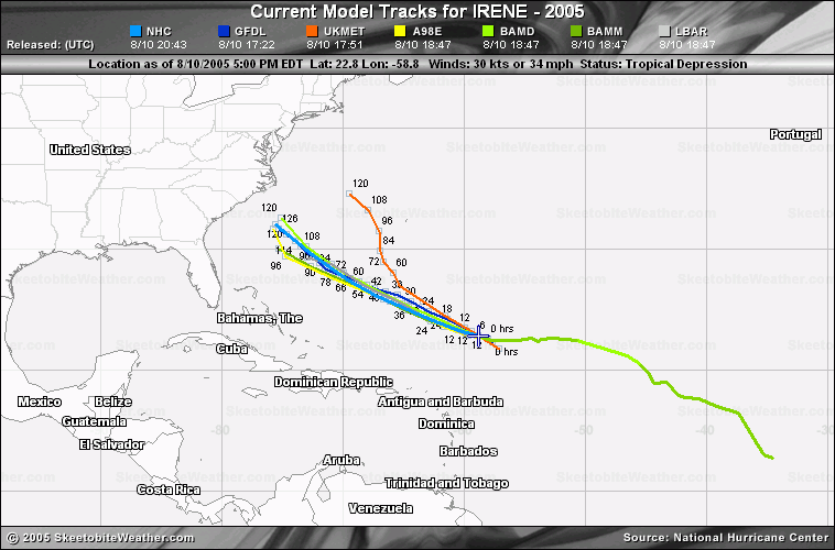
Latest plots on Irene she maybe saying hello to NY,NY or NJ....
PLOTS Latest Model runs
|
Clark
Meteorologist
Reged: Wed
Posts: 1710
Loc:
|
|
Brad -- no worries.
craigm -- water vapor looks at the middle levels of the atmosphere, generally from 300-600mb.
Irene looks to becoming a bit better organized tonight, with the LLC on the NW side of the deep convection. It should be a TS again at 11p; if not then, definitely by 5a. It'll probably perk up a bit more overnight during the diurnal convective maximum -- not a lot, however -- before settling down into tomorrow. Threat is there for anywhere along the SE coast...Florida is lessening the further north this gets. Don't feel it's a S Florida storm, but not ready to sound an "all clear" south of Cape Canaveral just yet. Time frame...Monday-Tuesday most likely.
--------------------
Current Tropical Model Output Plots
(or view them on the main page for any active Atlantic storms!)
|
Kevin
Weather Master
Reged: Fri
Posts: 524
Loc: EC Florida
|
|
Man, these models are really all over the place. Compared to the 12 and 18Z runs, the latest output of the tropical models represents a hell of a shift.
I do agree that the system is moving WNW now...recent frame(s) have cleared my earlier thoughts up.
A lot of uncertainty, going to be interesting for the EC...
|


 Threaded