danielw
Moderator

Reged:
Posts: 3525
Loc: Hattiesburg,MS (31.3N 89.3W)
|
|
HURRICANE TROPICAL CYCLONE POSITION ESTIMATE
NWS TPC/NATIONAL HURRICANE CENTER MIAMI FL
12 AM EDT FRI AUG 26 2005
AT 12 AM EDT...0400Z...THE EYE OF HURRICANE WAS ESTIMATED
BY RADAR NEAR LATITUDE 25.5 NORTH...LONGITUDE 81.0 WEST. THIS
POSITION IS INLAND OVER THE EVERGLADES IN EASTERN MAINLAND MONROE
COUNTY FLORIDA...ABOUT 40 MILES SOUTHEAST OF MARCO ISLAND FLORIDA
AND ABOUT 70 MILES NORTHEAST OF KEY WEST FLORIDA.
FORECASTER KNABB
It doesn't look to be long now!!~danielw
|
Frank P
Veteran Storm Chaser
Reged:
Posts: 1299
|
|
Danny boy go to the NWS experimental radar site, select the still radar image, left click on the center of the eye, then drag you curser to the western edge of FL....looks like 12-13 tto the coast
another observation from tonight... has been taking slow down for two days... well its not slowing down which could indicate that the ridge is stronger than anticipated, nor weakening as fast as they expected, system also went more south than projected from earlier forecasts....... now what this does to the final landfall point remains to be seen....
radar link
http://www.srh.noaa.gov/ridge/byx.shtml
Edited by Frank P (Fri Aug 26 2005 04:19 AM)
|
Random Chaos
Weather Analyst

Reged:
Posts: 1024
Loc: Maryland
|
|
Meanwhile, with all our occupied time tracking , we've forgotten about the storm that just hit Japan tonight:
http://www.nrlmry.navy.mil/tc-bin/tc_hom...es&DISPLAY=
(and now I sleep...long day today...and now a long day tomorrow it looks like! Storm tracking is fun.)
Edited by Random Chaos (Fri Aug 26 2005 04:23 AM)
|
LI Phil
User

Reged:
Posts: 2637
Loc: Long Island (40.7N 73.6W)
|
|
one last time, at least for the wee hours of friday, i will ask ya'll to take a look at katrina's sw us wv loop...
i'd say she's in the GOM by 4 am and strengthening...and NOT particularly following ANY of the current paths the models have...
3 dead now, btw, with
sad
tamiami=7.3"...damn near john holmes territory there...
--------------------
2005 Forecast: 14/7/4
BUCKLE UP!
"If your topic ain't tropic, your post will be toast"
|
danielw
Moderator

Reged:
Posts: 3525
Loc: Hattiesburg,MS (31.3N 89.3W)
|
|
I think there's more to that Tamiami report.
This link is showing a storm total of over 21 inches.
Scroll down and select "Storm Total".
Gives a good look at the path of the storm too!
http://weather.cod.edu/analysis/paulradar.pl?AMX
What happened to the storm center? It looks to have jumped toward the coast!!
|
Frank P
Veteran Storm Chaser
Reged:
Posts: 1299
|
|
Mr. Phil, I've looked at your very pretty water vapor loop, what specifically are you indicating and trying to point out per the loop... Help this dysfunctional Italiano understand and feel your pain... I can see the sw motion of the system but can't discern the eye feature... I don't see any driving troughs coming from the north that going to sweep Ms off her feet and immediately pull her to the north or ne as some claim... work with me Phil and provide me some much need edification on this pretty sat presentation that you are so fond of please sir... 
and I think your right about her and the models... good call
|
DebbiePSL
Weather Guru
Reged:
Posts: 151
Loc: Saint Marys Georgia
|
|
The last update I saw on Dr Lyons said this storm would enter the gulf in the next couple of hours. I think it was around midnight when I heard him say that.
|
Frank P
Veteran Storm Chaser
Reged:
Posts: 1299
|
|
yeah looks likes its less than 10 miles from coast... that's weird huh? ~ 7 as best I can tell...
|
LI Phil
User

Reged:
Posts: 2637
Loc: Long Island (40.7N 73.6W)
|
|
Quote:
Mr. Phil, I've looked at your very pretty water vapor loop, what specifically are you indicating and trying to point out per the loop... Help this dysfunctional Italiano understand and feel your pain... I can see the sw motion of the system but can't discern the eye feature... I don't see any driving troughs coming from the north that going to sweep Ms off her feet and immediately pull her to the north or ne as some claim... work with me Phil and provide me some much need edification on this pretty sat presentation that you are so fond of please sir... 
and I think your right about her and the models... good call
MY pretty wv loop?
hardly...i need to get some "beauty sleep" as sunday we could be looking at a cat III just south of biloxi...but that's like 72+ hours out right now...so...
as you know...if you need only the facts, just watch steve lyons on ...
if you want the truth ...read scotsvb's forecasts...
--------------------
2005 Forecast: 14/7/4
BUCKLE UP!
"If your topic ain't tropic, your post will be toast"
|
SirCane
Storm Tracker

Reged:
Posts: 249
Loc: Pensacola, FL
|
|
Bad part is, the water up here at the Northern Gulf Coast is like 90 degrees. It could get ugly.......
--------------------
Direct Hits:
Hurricane Erin (1995) 100 mph
Hurricane Opal (1995) 115 mph
Hurricane Ivan (2004) 130 mph
Hurricane Dennis (2005) 120 mph
http://www.hardcoreweather.com
|
Margie
Senior Storm Chaser

Reged:
Posts: 1191
Loc: Twin Cities
|
|
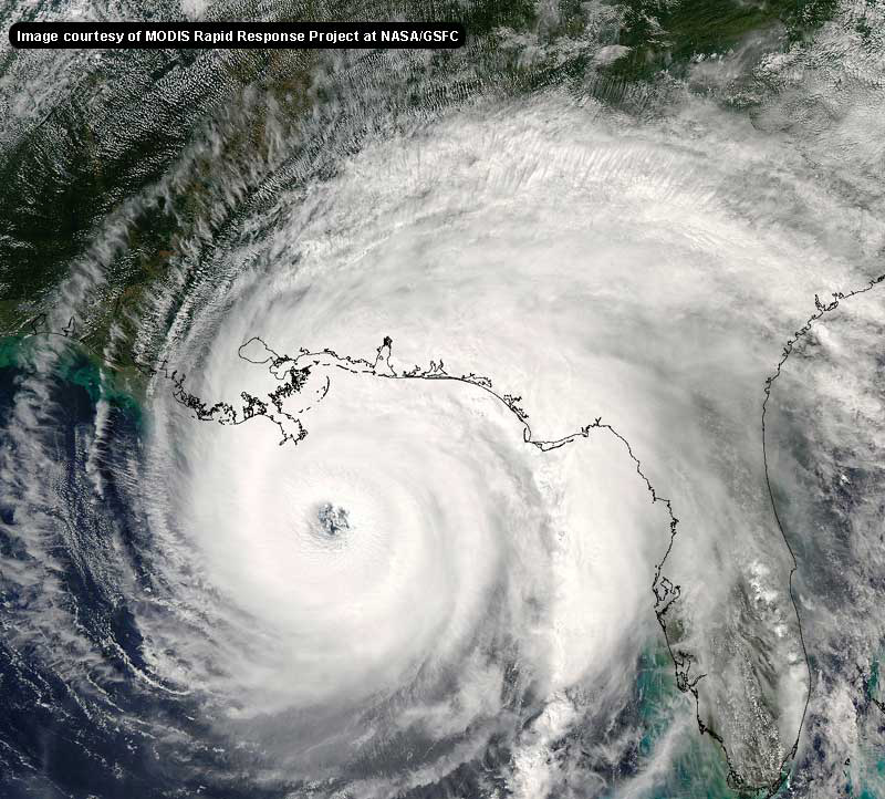
Check out the radar...in the last 1/2 hour look how quickly the west side of the circ built up as soon as it got over water. There was nothin' much there the entire time over land, and then presto the whole SW side looking rather together.
I think I'm going to stay up another hour 'cause I want to see this on radar. I bet soon as the COC gets offland it'll be re-forming very quickly.
--------------------
Katrina's Surge: http://www.wunderground.com/hurricane/Katrinas_surge_contents.asp
|
Frank P
Veteran Storm Chaser
Reged:
Posts: 1299
|
|
you beat me to the punch... I was going to comment on the explosion on the western side of the eye wall.... notice its also in the GOM thus the explosion... next couple of days is going to be interesting.... expect the pucket pressure on the Gulf Coast to get really high...
Phil I sure as hell don't want no Cat 3 south of me.... besides all the storms want to go to FL, especially to poor Pensacola.... their water is so much cleaner and nicer than outs... anything east of me is acceptable... later dude 
|
LI Phil
User

Reged:
Posts: 2637
Loc: Long Island (40.7N 73.6W)
|
|
check your pm's first...
--------------------
2005 Forecast: 14/7/4
BUCKLE UP!
"If your topic ain't tropic, your post will be toast"
|
danielw
Moderator

Reged:
Posts: 3525
Loc: Hattiesburg,MS (31.3N 89.3W)
|
|
HURRICANE TROPICAL CYCLONE UPDATE
NWS TPC/NATIONAL HURRICANE CENTER MIAMI FL
1240 AM EDT FRI AUG 26 2005
..AT 1240 AM EDT... 0440Z... THE TROPICAL STORM WARNING HAS BEEN
EXTENDED WESTWARD FROM KEY WEST FLORIDA TO DRY TORTUGAS. A
TROPICAL STORM WARNING IS NOW IN EFFECT FOR ALL OF THE FLORIDA KEYS
AND FLORIDA BAY FROM DRY TORTUGAS NORTHWARD...AND ALONG THE GULF
COAST OF FLORIDA FROM LONGBOAT KEY SOUTH AND EASTWARD TO SOUTH OF
FLORIDA CITY.
FORECASTER KNABB
To quote Porky Pig....It ain't over yet!~danielw
Edited by danielw (Fri Aug 26 2005 04:54 AM)
|
Frank P
Veteran Storm Chaser
Reged:
Posts: 1299
|
|
got it Phil, thanks
for some reason my little message icon was not lighting up as usual...
looks like the edge of the center is now approaching the coast line.... center should be totally in the GOM in the next couple of hours... then things are going to get REALLY interesting.... would like to commend the excellent job the mods are doing as usual, and the truly great and outstanding posts that have been provided by the family members during the past several days... I can't remember in all the years of posting any better posts than whats occurred here on the board thus far with ...
|
Margie
Senior Storm Chaser

Reged:
Posts: 1191
Loc: Twin Cities
|
|
From the 10a PA:
"Maximum sustained winds... 70 mph. Minimum central pressure... 990 mb."
Didn't lose much...going SW, and at that fast clip, really minimized time over land, and also kept the feeder bands over water. Who would've thought at 6pm EDT, that seven hours later would be headed offshore?
Poor Naranja and Princeton...still getting socked with feeder bands, the area of 12"+ of rain is spreading.
OK I'm fallin' asleep at the wheel here...so to speak...good night all, I'll try not to get post-happy in the am! Still tickled about my 7:30pm guess as to where would exit FL. Guess odds were that I'd have to get one right eventually.
Edited by Margie (Fri Aug 26 2005 05:25 AM)
|
Frank P
Veteran Storm Chaser
Reged:
Posts: 1299
|
|
absolute NO ONE forecast her to do that... none, zero, nada.... big surprise to me too... can only wonder what, if any, impact it will have to the second landfall of this system... that's about the only thing I think I could forecast accurately , that it will have a second landfall somewhere..... not going out on a limb now am I... hehe
|
ralphfl
Weather Master
Reged:
Posts: 435
|
|
well it could loop under florida and go out to sea right?  J/K but with a storm i guess you could not rule it out totally. J/K but with a storm i guess you could not rule it out totally.
Still never got a answer to my question...Is this storm larger in size Like francis or is it like charlie as to me it does not seem to be a large storm
Also is it me or does it look like in the radar loop dry air coming in to it from the north or just it going southwest
Edited by ralphfl (Fri Aug 26 2005 05:24 AM)
|
danielw
Moderator

Reged:
Posts: 3525
Loc: Hattiesburg,MS (31.3N 89.3W)
|
|
It was more like in size.
Right now she is barely hanging on to the center of circulation. It appeared to be near collapse just before the western eyewall reached the beach.
Update. Last radar update shows a clearly defined 'eye'.
Edited by danielw (Fri Aug 26 2005 05:24 AM)
|
tpratch
Moderator

Reged:
Posts: 339
Loc: Maryland
|
|
Frances started falling apart before landfall, actually ballooning in size while doing so. Chunks of her windfield were drifting off while maintaining some semblence of circulation. Some of her highest gusts here recorded well away from her center (unless of course, I'm thinking of Jeanne).
As mentioned above, is closer in size to , although with the warmth in the gulf, I'd be unsurprised to see her deepen and grow much larger as the next few days go by...
|


 Threaded


 J/K but with a storm i guess you could not rule it out totally.
