Multi-Decadal Signal
Weather Guru
Reged:
Posts: 149
Loc: BROWARD
|
|
Post deleted by the ongoing active Atlantic multi-decadal signal
|
Hugh
Senior Storm Chaser
Reged:
Posts: 1060
Loc: Okaloosa County, Florida
|
|
Quote:
People are very resistant to evacuation orders and don't seem to value their lives as much as their possessions, they fear looters while they're away, or just the expense and inconvenience of leaving town for higher ground.
Not being an alarmist or crying wolf and certainly NOT relishing the prospect of seeing 500 or 5,000 or 50,000 souls swept away. I fear the loss of many more than on 9/11 plus this damn war + ???. I fly the storm flags upside down because of what I see as a very real chance of an horrific disaster.
One and only one word can describe what is impending for the greater N.O. area: doom.
is there ANYTHING that could cause to weaken? NOT Yet~danielw
Just saw the LIVE shot of I-10 leaving N.O. on the Weather Channel...   
Good bye, New Orleans. Edit: If things do not change for the positive and this thing does what I think it will do.... will New Orleans be rebuilt? It could take a LONG time to pump the water out.
--------------------
Hugh
Eloise (1975) - Elena and several other near misses (1985) - Erin & Opal (1995) - Ivan (2004)
Edited by danielw (Sun Aug 28 2005 10:49 AM)
|
Margie
Senior Storm Chaser

Reged:
Posts: 1191
Loc: Twin Cities
|
|
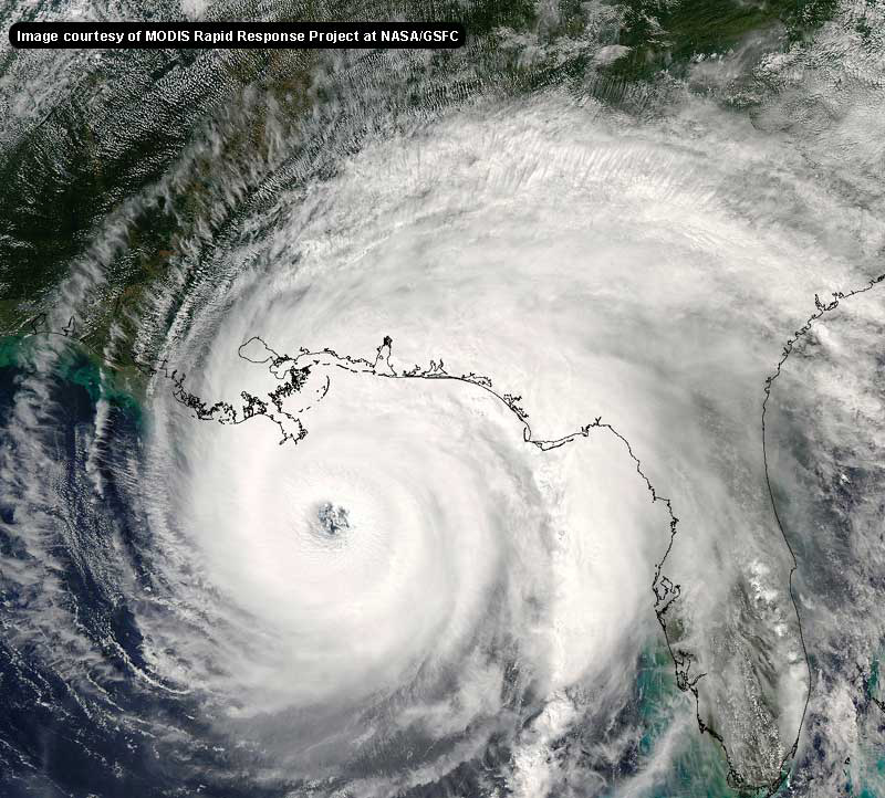
1) thanks for that additional sat image. I noticed that there were 2 addl images since the recon with the (extrap) 915mb reading. To me, it looks like the central circ got even cleaner and stronger in that additional hour.
2) Unbelieveable about the NO evac. Right now I estimate weather conditions will deteriorate starting around 3 or 4 pm. This is because she has increased in size and because she's moving faster. How long does he think he can wait before deciding people HAVE to leave? I guess there isn't anyone to tell him it should have been about two days ago.
--------------------
Katrina's Surge: http://www.wunderground.com/hurricane/Katrinas_surge_contents.asp
Edited by Margie (Sun Aug 28 2005 10:49 AM)
|
Hugh
Senior Storm Chaser
Reged:
Posts: 1060
Loc: Okaloosa County, Florida
|
|
Quote:
2) Unbelieveable about the evac. Right now I estimate weather conditions will deteriorate starting around 3 or 4 pm. This is because she has increased in size and because she's moving faster. How long does he think he can wait before deciding people HAVE to leave? I guess there isnt' anyone to tell him it should have been about two days ago.
There were several people HERE to tell him... but that's not important right now. I'm sure that there will be time after the storm to evaluate the decisions made at ground zero - time for others to evaluate the decisions, I mean, so that, God forbid, we get another super storm in the forseeable future, things are done differently.
Having said that, what really could be done differently? By the time N.O. had any clue what they were in for... it was too late to evacuate everyone, I honestly believe.
Edit:: SHIPS models now indicate 162 mph in 24 hours. BAMM updated to project landfall west of the city.
Edot 2" Weather channel just said may even get better organized than this - I think that is what she said. You don't GET any better organized than this. You only get stronger - but the organization doesn't really get much better than "perfect storm", does it?
--------------------
Hugh
Eloise (1975) - Elena and several other near misses (1985) - Erin & Opal (1995) - Ivan (2004)
Edited by Hugh (Sun Aug 28 2005 10:53 AM)
|
pcola
Storm Tracker

Reged:
Posts: 344
Loc: pensacola/gulf breeze
|
|
Local weather here in Pcola says that if follows its projected track, we will have 70 plus mph winds here in Pensacola..thats incredible being 175 miles away...I hope S Mississippi and Bama are awake
--------------------
Erin 95 , Opal 95, Ivan 04, Dennis 05, and that's enough!!!!
|
SirCane
Storm Tracker

Reged:
Posts: 249
Loc: Pensacola, FL
|
|
Don't forget how looked.... Very similar and the same sized eye.........
http://www.noaanews.noaa.gov/stories2004/images/ivan091504-2015z2.jpg
--------------------
Direct Hits:
Hurricane Erin (1995) 100 mph
Hurricane Opal (1995) 115 mph
Hurricane Ivan (2004) 130 mph
Hurricane Dennis (2005) 120 mph
http://www.hardcoreweather.com
|
Hugh
Senior Storm Chaser
Reged:
Posts: 1060
Loc: Okaloosa County, Florida
|
|
Quote:
Don't forget how looked.... Very similar and the same sized eye.........
http://www.noaanews.noaa.gov/stories2004/images/ivan091504-2015z2.jpg
Ivan was doomed by cooler water from earlier storms (I think), and also from shear. I see neither in 's path.
--------------------
Hugh
Eloise (1975) - Elena and several other near misses (1985) - Erin & Opal (1995) - Ivan (2004)
|
SirCane
Storm Tracker

Reged:
Posts: 249
Loc: Pensacola, FL
|
|
I was talking about earlier in 's period but was a nightmare here. will be worse and that is hard to imagine.
--------------------
Direct Hits:
Hurricane Erin (1995) 100 mph
Hurricane Opal (1995) 115 mph
Hurricane Ivan (2004) 130 mph
Hurricane Dennis (2005) 120 mph
http://www.hardcoreweather.com
|
RedingtonBeachGuy
Moderator
Reged:
Posts: 342
Loc: St. Cloud, FL
|
|
To maintain the quality of information, please remember to follow the posting rules:
Before you post: Before posting, please ask yourself the following question: "Am I making a post which is informative, or interesting or adds to thoughtful discussion on any level? If is a reply, does it offer any significant advice or help contribute to the conversation in any fashion?" If you can answer "yes" to this, then please post. If you cannot, then refrain from posting.
Low Content Posts: Please do not make single line posts containing no content (ie, "Thanks!" "Great Post" "Cool!", "I agree", or something else completely void of meaning). Or general cheerleading, for example, if you think someone did a good job and have nothing else to add send them a PM, it works better for this. We appreciate the thanks, but otherwise posts like these just litter up the forums. Remember, is not a Chat Room - it is a Niche topic-oriented site, so please attempt to stay 'on topic' by placing your posts in the proper Forum. Main page articles are usually focused on one particular topic, the other forums are open to use as well and are moderated less strictly.
|
stormchazer
Storm Tracker

Reged:
Posts: 315
Loc: Central Florida
|
|
Foxnews now calling Cat 5 storm according to .
Sorry for low content.
--------------------
Jara
*************************************************************
Edited by stormchazer (Sun Aug 28 2005 11:21 AM)
|
Margie
Senior Storm Chaser

Reged:
Posts: 1191
Loc: Twin Cities
|
|
Quote:
Local weather here in Pcola says that if follows its projected track, we will have 70 plus mph winds here in Pensacola..thats incredible being 175 miles away...I hope S Mississippi and Bama are awake
This could be nothing, but is just a hair east of the last forecast point. It could mean nothing, as she is a very large storm, but then again, as is currently curving, it could translate to 20 or 30 miles at landfall. It'll be real intersesting to see if there are any shifts east to the track at the 10am. This would mostly affect MS Gulf Coast. Such a track shift would spare NO the worst but would be similar to a Camille situation for MS.
Take this with a grain of salt. It's a valid observation and a conculsion, but I know this is a situation that is highly charged and am not trying to juice it up any further.
If you are on the MS Gulf Coast then check the 10am for this possibility.
--------------------
Katrina's Surge: http://www.wunderground.com/hurricane/Katrinas_surge_contents.asp
|
Hugh
Senior Storm Chaser
Reged:
Posts: 1060
Loc: Okaloosa County, Florida
|
|
I also heard on that winds are now 160. Incredible strengthening period is apparently in full bloom. How strong could conceivably get? Looking at the advisories on Camille last night, the estimated winds at that time were 190 (they were actually 200+ but no one could measure winds that strong). It's speculation - but is now within 5 mph of Andrew's strength - could it get significantly stronger? It would be nearly unprecidented, except for Camille.
--------------------
Hugh
Eloise (1975) - Elena and several other near misses (1985) - Erin & Opal (1995) - Ivan (2004)
Edited by RedingtonBeachGuy (Sun Aug 28 2005 11:30 AM)
|
Multi-Decadal Signal
Weather Guru
Reged:
Posts: 149
Loc: BROWARD
|
|
There was a URL posted here, somewhere, for a double page spread in a NO newspaper which examined the very possibilities which we are facing now. Unfortunately, I can't seem to find it. I saw it in the last day or so. It might have been from the paper's archive and not a current article.
The article was most informative should it be found again. Post it if found, please.
--------------------
Who you gonna' believe?
Me, or your damn lying eyes?
_Ö_ _ö_
Edited by the ongoing active Atlantic multi-decadal signal (Sun Aug 28 2005 07:40 PM)
|
recmod
Weather Guru

Reged:
Posts: 188
Loc: Orlando, FL
|
|
068
WTNT62 KNHC 281117
TCUAT2
HURRICANE TROPICAL CYCLONE UPDATE
NWS TPC/NATIONAL HURRICANE CENTER MIAMI FL
615 AM CDT SUN AUG 28 2005
...KATRINA NOW A CATEGORY FIVE HURRICANE WITH 160 MPH WINDS...
...AT ABOUT 605 AM CDT... 1105Z... AN AIR FORCE RECONNAISSANCE
AIRCRAFT REPORTED THAT MAXIMUM SUSTAINED WINDS IN HURRICANE
HAVE INCREASED TO NEAR 160 MPH. IS NOW AN EXTREMELY
DANGEROUS CATEGORY FIVE HURRICANE ON THE SAFFIR-SIMPSON HURRICANE
SCALE.
FORECASTER KNABB
|
RedingtonBeachGuy
Moderator
Reged:
Posts: 342
Loc: St. Cloud, FL
|
|
Here is a live TV feed from New Orleans if it interests anyone:
*requires a Windows Media player*
mms://beloint.wm.llnwd.net/beloint_wwltv
Latest view of :
http://cimss.ssec.wisc.edu/tropic/real-time/atlantic/storm/archive/javawv2.html
|
Margie
Senior Storm Chaser

Reged:
Posts: 1191
Loc: Twin Cities
|
|
Quote:
...KATRINA NOW A CATEGORY FIVE HURRICANE WITH 160 MPH WINDS...
I had wondered after that last recon...it was NW to SE, max fl winds 144kt, and I thought where are the numbers for the NE quad? With 915mb and 12 deg temp diff, that was the only thing missing for Cat 5 status.
Because so much is riding on this, I think was waiting for more data to see if it was transient or if it was solid, to make the call.
--------------------
Katrina's Surge: http://www.wunderground.com/hurricane/Katrinas_surge_contents.asp
|
Hugh
Senior Storm Chaser
Reged:
Posts: 1060
Loc: Okaloosa County, Florida
|
|
Quote:
Because so much is riding on this, I think was waiting for more data to see if it was transient or if it was solid, to make the call.
Probably - the words Cat 5 have a tendency to cause mass hysteria. With a pressure now down to 910, though... there is no doubt. The only question is where specifically she'll end up and how much strong she will get. A few miles east or west will mean a lot in terms of where the destruction occurs - not if it occurs but just where.
It appears to be gradually turning - weather channel has a plot where they show the line, and it's definately right of the previous track - headed for the big easy or slightly east.
EDIT: With a pressure of 910, if my memory is correct, is now the 3rd strongest hurricane on record - only Camille (908?) and Gilbert (897?) had lower pressures. I'm using my memory so this may not be the case.
--------------------
Hugh
Eloise (1975) - Elena and several other near misses (1985) - Erin & Opal (1995) - Ivan (2004)
Edited by Hugh (Sun Aug 28 2005 11:50 AM)
|
ralphfl
Weather Master
Reged:
Posts: 435
|
|
Good morning before i go out i wanted to chime in and say my prayers are with whoever this storms hits but looking at the discussion at 5am it shows weaking at landfall.As i said the other day shear is forcasted in the area so we can hope and pray that it will be more then what they are saying and drop at leasy back to a 3 which is devastating also.They have it droping back to a 4 only so with this speed going faster today now i think they may even more it more west the track if the speed holds and wnw track keeps up for the day.
Ill ptay today that the shear gets stronger so before landfall we can pray it will lessen some.
This looks to be going west of N.O when it hits with the speed and the motion unless it gets going due north very soon today.
Edited by ralphfl (Sun Aug 28 2005 11:58 AM)
|
recmod
Weather Guru

Reged:
Posts: 188
Loc: Orlando, FL
|
|
Katrina continues to strengthen and the central pressure is down to 910mb!!!!!!!!! Here's the latest vortex data:
000
URNT12 KNHC 281120
VORTEX DATA MESSAGE
A. 28/11:04:10Z
B. 25 deg 39 min N
087 deg 32 min W
C. 700 mb 2310 m
D. NA kt
E. deg nm
F. 141 deg 153 kt
G. 046 deg 018 nm
H. 910 mb
I. 10 C/ 3056 m
J. 25 C/ 3057 m
K. 10 C/ NA
L. CLOSED WALL
M. C25
N. 12345/ 7
O. 1 / 1 nm
P. AF302 1712A OB 10
MAX FL WIND 153 KT NE QUAD 10:58:50 Z
--Lou
|
WhitherWeather
Verified CFHC User
Reged:
Posts: 20
|
|
Pressure has just been reported as having dropped to 910. This is Camille levels--and is bigger.
WitherWeather
|


 Threaded


