pcola
Storm Tracker

Reged:
Posts: 344
Loc: pensacola/gulf breeze
|
|
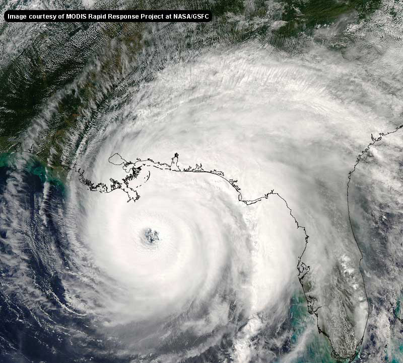
I think we are going to continue to see a shift east in the forecat track...the storm is definately continuing to be north and east of the forecast points, and we may see the 11 am track very close to the la/tx border, with a possible farther east track later...I am looking forward to the new model runs that will take into account the movement changes last evening...i hope the focus on houston has not made anyone along the lA coast feel safe
--------------------
Erin 95 , Opal 95, Ivan 04, Dennis 05, and that's enough!!!!
Edited by pcola (Thu Sep 22 2005 11:23 AM)
|
jr928
Weather Guru
Reged:
Posts: 101
|
|
yes, all but 3 are in agreement, but every single one of those models is further north and east of yesterdays projections.
|
Marji
Registered User
Reged:
Posts: 2
Loc: Atlanta, GA
|
|
New here but really wanted to share something that scares me.
Check this historical link -
http://www.wunderground.com/tropical/tracking/at200518_climo.html
I have family(Mobile and New Orleans) that has been through and lost friends(Gulf Port) in so I
am really concerned because if she turns the amount of time they have is about half of what Texas has now.
Marji
Edited by Marji (Thu Sep 22 2005 11:34 AM)
|
collegemom
Weather Hobbyist

Reged:
Posts: 82
Loc: Central Arkansas
|
|
Hmmmmm. She's just about where they all abruptly turned.
--------------------
character has been defined as what we do when no one is looking
|
Joshua
Weather Watcher
Reged:
Posts: 43
Loc: Fort Lauderdale, FL
|
|
Latest recon is at 907mb and ~150kt fl winds. Wonder if the 8am adv. will be any different. We'll see. You can also seeing the cloud tops warming on IR sat.
|
Joshua
Weather Watcher
Reged:
Posts: 43
Loc: Fort Lauderdale, FL
|
|
Yes, 170 with 907mb. Slight weakening anticipated. It couldn't have stayed at 175 for long.
|
Texascoast
Registered User
Reged:
Posts: 7
|
|
What is it turning right into a high presher ridge? the high everyone has been talking about moving east has not moved east and the storm is turning into it, what i dont under stand. Can someone explain.
|
Terra
Storm Tracker
Reged:
Posts: 286
Loc: Kingwood, Texas
|
|
Steering currents seem to have less influence on large, powerful storms. They essentially go where they want to go... luckily though, it is harder to turn a mack-truck than a car, so they don't generally turn as dramatically, but they still have a mind of their own.
--------------------
Terra Dassau Cahill
|
Texascoast
Registered User
Reged:
Posts: 7
|
|
So is going to try to penatrate the high, wouldnt the high stall it.
|
Terra
Storm Tracker
Reged:
Posts: 286
Loc: Kingwood, Texas
|
|
Doesn't look that way.... Holy Moly... last three hours were NW... 0.3N, 0.3W. Everytime the track is adjusted, ends up slightly north of the new forecast points. This is extremely bothersome to me....
--------------------
Terra Dassau Cahill
|
SirCane
Storm Tracker

Reged:
Posts: 249
Loc: Pensacola, FL
|
|
Hmm, looks interesting. I had a feel she might turn Northward sooner than predicted.
--------------------
Direct Hits:
Hurricane Erin (1995) 100 mph
Hurricane Opal (1995) 115 mph
Hurricane Ivan (2004) 130 mph
Hurricane Dennis (2005) 120 mph
http://www.hardcoreweather.com
|
Rick on boat in Mobile
Weather Drama Guru

Reged:
Posts: 161
|
|
was initially what I thought......and when I posted I thought New Orleans was NOT out of the woods....it was bashed.
not now.
Texas is spared......
hopefully she will weaken to a 3
New Orleans is in her sights....I'm afraid...maybe east of that....and not much time now....
I wouldn't rule out a turn north today...and then NNE....at all....
the has decreased...perhaps she is in a permanent weakening state....
rick, you've got about zero model support for that track. you're making trends out of wiggles... but your intensity makes more sense. -HF
Edited by HanKFranK (Thu Sep 22 2005 01:41 PM)
|
Hugh
Senior Storm Chaser
Reged:
Posts: 1060
Loc: Okaloosa County, Florida
|
|
Quote:
Hmmmmm. She's just about where they all abruptly turned.
I just sent someone a private message.... she LOOKS (to me) like she's poised for the great right hook. NOT GOOD. Not saying it's going to happen by any stretch... just saying that it looks to me like it could... and climatology is not making me comfortable.
notice the cone hasn't shifted right.. that's because every update cycle it goes far enough west that a further shift only takes it to places within the narrowing cone. it's still tx/la, so you're about as safe as can be. -HF
Edited by HanKFranK (Thu Sep 22 2005 01:44 PM)
|
GuppieGrouper
Weather Master
Reged:
Posts: 596
Loc: Polk County, Florida
|
|
http://radar.weather.gov/radar/loop/DS.p37cr/si.ktbw.shtml
I know this is off topic but it is kind of interesting and important and is the fringe of . Is this an optical illusion of a low pressure swirl trying to form over Tampa Bay? If this is deleted I will understand.
--------------------
God commands. Laymen guess. Scientists record.
|
Jonathan Franklin
Verified CFHC User
Reged:
Posts: 11
Loc: Miami, Florida
|
|
Having watched and closely skirt us here in South Florida, one thing became apparent, neither storm, or really any storm, follows directly the consensus. Keep an eye on it. , at its infancy, scooted much further south than the consensus, when it hit Miami-Dade County, Florida - following one model nearly spot on. , too, did not go as far north as projected. It seems to me, that has the potential to skirt around on the outer corners of the projected models. LA darn sure better watch out, but I would NOT breath a sigh of relief if I were anywhere between Corpus Christi and New Orleans. Texas and Louisiana are both in play. This storm should be taken very seriously. Plus, given its size, it may have other plans than what we would typically expect. And while it has weakened...not really, it certainly could gain strength again.
I suspect the 11 AM EDT discussion will provide some clarity, but as the will readily admit, within 24 hours, their best guess has a margin of error of 80 nautical miles (~92 standard land miles). 
We are praying for those folks!
Respectfully,
Jonathan
|
Beach
Weather Guru

Reged:
Posts: 187
Loc: Cocoa Beach/Banana River
|
|
Yeah I think we can all see that the center of the storm is just a bit North and East of the forcast points.
If the storm makes landfall between Houston and
Western LA, New Orleans will be in the worst part of the storm. Even without a direct hit can't we expect levee failure again? 
|
SirCane
Storm Tracker

Reged:
Posts: 249
Loc: Pensacola, FL
|
|
I definately see a NW turn. Check out this out. I think Texas may dodge a big bullet..... http://www.click2weather.com/wxmap/4290829/detail.html
--------------------
Direct Hits:
Hurricane Erin (1995) 100 mph
Hurricane Opal (1995) 115 mph
Hurricane Ivan (2004) 130 mph
Hurricane Dennis (2005) 120 mph
http://www.hardcoreweather.com
|
pryord1
Weather Watcher
Reged:
Posts: 49
Loc: Navarre, FL
|
|
Quote:
Quote:
Hmmmmm. She's just about where they all abruptly turned.
I just sent someone a private message.... she LOOKS (to me) like she's poised for the great right hook. NOT GOOD. Not saying it's going to happen by any stretch... just saying that it looks to me like it could... and climatology is not making me comfortable.
If that's so, then what is up with the high pressure system? Is it weakening or lifting earlier than anticipated or is just so powerful that she can go wherever she wants?
--------------------
The key to a good life is higher thought. Challenge yourself, push your personal limits and go for the brass ring!
|
Tazmanian93
Weather Master

Reged:
Posts: 495
Loc: Tampa
|
|
I switched to Long Range, and looked at WV and IR and did not see it, on your SR I did see what looked like a circulation though, maybe the eyes. I wake up this morning and look at the broken ridge not to my surprise, see more of NO in the cone, not a surprise
--------------------
Don't knock the weather; nine-tenths of the people couldn't start a conversation if it didn't change once in a while.
Go Bucs!!!!!!!!!
****************
Ed
|
tpratch
Moderator

Reged:
Posts: 339
Loc: Maryland
|
|
I think it's FAR too early to start saying Texas has dodged a bullet here. Let's not start this please. Look at the long-term trends, not short-term idiosyncracies...
|


 Threaded


